

Drive from Kathmandu to Nagarkot, about 1.5 hours, ideally for sunrise, and have tea before you start. The trail leaves the ridge and descends through pine and rhododendron forest and terraced fields, passing Tamang and Newar villages. About two and a half hours on, you reach Telkot, the midway rest stop, where you can visit a small monastery. The way continues downhill with a few gentle ascents to Changu Narayan, a hilltop temple on the UNESCO World Heritage list, where lunch and sightseeing end the day. On our map it is 11.7 km with 150 m of climbing and 535 m of descent, mostly on village roads and tracks. A vehicle back to Kathmandu takes about an hour.
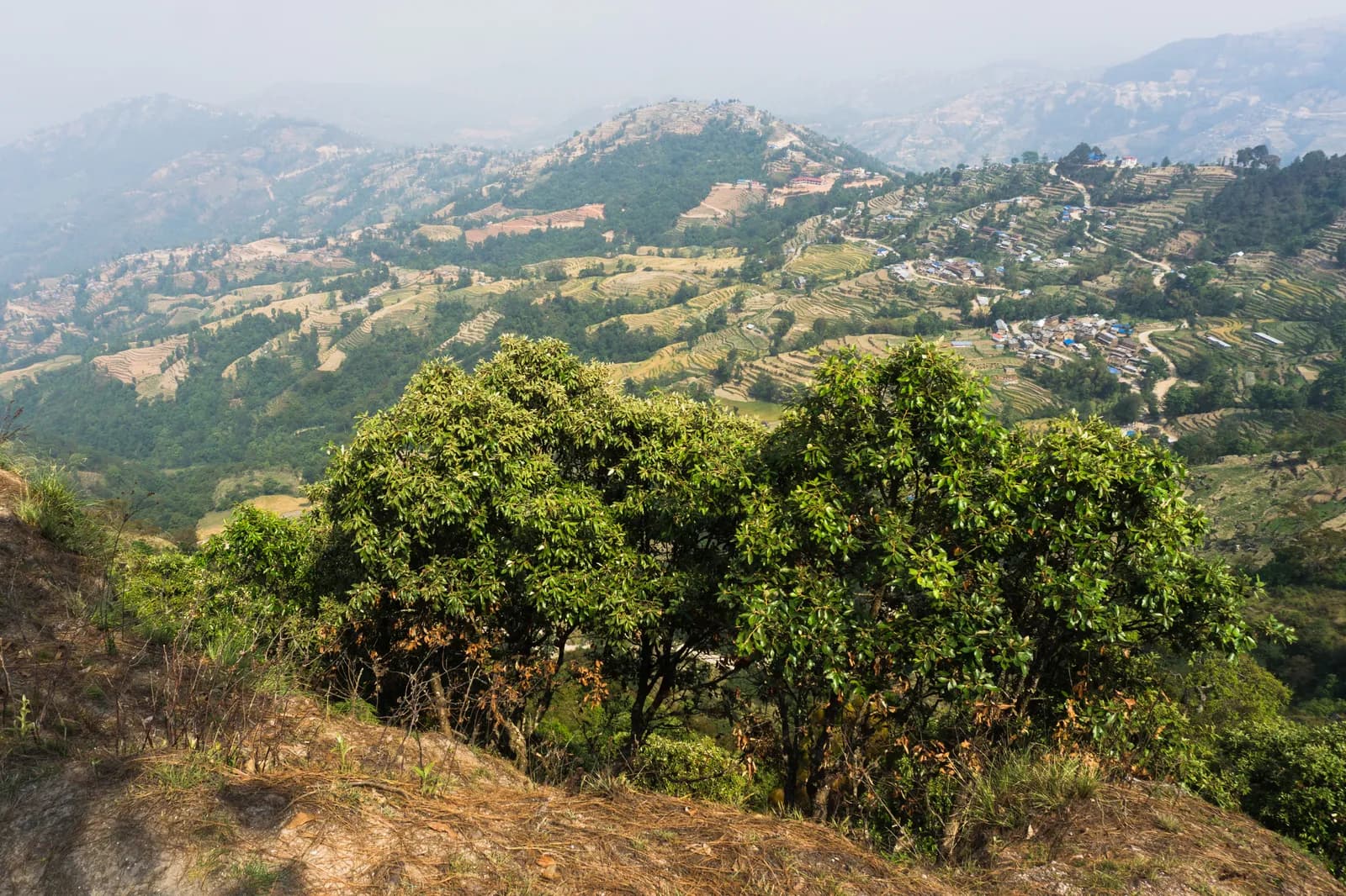
Nagarkot to Changu Narayan Day Hike
A one-day downhill walk from the ridge village of Nagarkot through Telkot and Newar and Tamang villages to Changu Narayan temple, 11.7 km on our map, mostly downhill.
- Ngày1
- Độ cao tối đa2.175 m
- Quãng đường11,7 km
- Độ cao leo149 m
- Độ khóDễ
- Tháng đẹp nhấtMar–May, Oct–Nov
Lên kế hoạch chuyến đi theo lịch trình nàyTìm bạn đồng hành cho Nagarkot to Changu Narayan Day HikeXem lịch khởi hành theo tuần
Ảnh: Alexey Komarov · CC BY-SA 4.0
Hiển thị bằng tiếng Anh — chưa được dịch.
Lịch trình này là bản nháp và chưa được xác minh. Luôn xác nhận các chặng với hướng dẫn viên của bạn.
Written by FindTrekkingPartner teamĐược FindTrekkingPartner team kiểm duyệtCách chúng tôi kiểm duyệtFindTrekkingPartner
Nagarkot to Changu Narayan Day Hike là chuyến trek 1 ngày ở vùng Kathmandu Valley của Nepal, leo lên độ cao 2.175 m. Trekker nước ngoài có thể tìm bạn đồng hành cho chuyến này trên FindTrekkingPartner bằng cách đăng chuyến đi kèm ngày đi, ngân sách và tốc độ. Các kết nối được giữ riêng tư cho đến khi cả hai trekker đồng ý, và dịch vụ này miễn phí. Ở mức giá tầm trung, một hướng dẫn viên có giấy phép tốn khoảng 9 USD mỗi người trong 1 ngày khi bốn trekker chia sẻ, so với 37 USD cho một trekker đi một mình. Các mùa đẹp nhất là Oct–Nov, Mar–Apr. Hướng dẫn viên có giấy phép không bị bắt buộc trên các cung đường mở như thế này (kiểm tra ngày 19 tháng 10 năm 2026): chính quyền Khumbu đã không áp dụng quy định tháng 4 năm 2023 của Cục Du lịch Nepal (Nepal Tourism Board) và các chuyến đi bộ trong ngày không cần hướng dẫn viên, nhưng vẫn rất nên có hướng dẫn viên, vì vậy hãy xác nhận với công ty lữ hành của bạn. Xác minh lần cuối: 19 tháng 10, 2026. Nguồn: Cục Du lịch Nepal (Nepal Tourism Board), DNPWC, Cục Xuất nhập cảnh.
Nguồn:Department of Immigration, NepalNepal Tourism BoardDepartment of National Parks and Wildlife Conservation
Tìm bạn đồng hành cho Nagarkot to Changu Narayan Day Hike
- Tìm bạn đồng hành cho Nagarkot to Changu Narayan Day HikeChưa có chuyến đi đang mở
- Tìm bạn đồng hành cho Shivapuri Peak Day HikeChưa có chuyến đi đang mở
- Tìm bạn đồng hành cho Chisapani Nagarkot TrekChưa có chuyến đi đang mở
- Tìm bạn đồng hành cho Champadevi Day HikeChưa có chuyến đi đang mở
- Tìm bạn đồng hành cho Phulchowki Day HikeChưa có chuyến đi đang mở
- Tìm bạn đồng hành cho Namo Buddha Day HikeChưa có chuyến đi đang mở
Tổng quan
Khởi hành từ Nagarkot1 ngày · tối đa 2.175 m
Mùa đẹp nhất: Mar–May, Oct–Nov
The Nagarkot to Changu Narayan hike is a one-day downhill walk from the ridge village of Nagarkot, about 2,150 m, through Telkot and a string of Tamang and Newar villages to the temple hill of Changu Narayan. On our map the walk is about 11.7 km with 150 m of climbing and 535 m of descent, on village roads, tracks and forest paths. Operators give about 14 km and four to five hours, with a rest stop at Telkot, so our shorter map line looks a little brisk. You drive about 1.5 hours from Kathmandu to Nagarkot, ideally in time for the sunrise view, and take about an hour back from Changu Narayan, or a short bus ride to Bhaktapur. The Nagarkot viewpoint and the Changu Narayan temple charge entrance fees. Carry water and lunch.
The plan follows two operator itineraries that agree on Nagarkot, Telkot and the temple, and on the timing of about four and a half hours with a break. Heights differ: sources give Nagarkot at 2,100 to 2,195 m, and Wikivoyage gives 2,163 m. The same descent is the last day of our Chisapani Nagarkot trek.
What the hike is like
The trail leaves Nagarkot's ridge and descends through pine and rhododendron forest and terraced fields, passing small Tamang and Newar villages. Telkot is the midway rest stop, with an optional monastery visit. The path is wide and easy as long as you wear hiking shoes, with a few gentle ascents. Changu Narayan sits on a hilltop. According to Wikipedia it was listed as a UNESCO World Heritage Site in 1979 and stands about 12 km east of Kathmandu, and a pillar there dates to 464 AD.
Permits and rules
None of our sources lists a park permit for this route. Two entrance fees apply: the Nagarkot viewpoint and the Changu Narayan temple, which operators include in their prices without giving amounts. Dress modestly at the temple and keep to the marked path.
Best season
October to November and March to May, according to operators, who also say it can be walked all year. Autumn and spring have the clearest mountain views; Nagarkot sunrise views are best before cloud builds.
Getting there and away
A taxi from Kathmandu to Nagarkot costs NPR 2,000 to 3,000 one way and takes 1.5 to 2 hours, according to Wikivoyage. Public buses via Bhaktapur cost under NPR 100 and take about two hours. From Changu Narayan a private vehicle takes about one hour to Kathmandu, or a short bus ride reaches Bhaktapur.
Difficulty and fitness
The route is easy: it descends 535 m over 11.7 km, on wide paths and quiet roads. Wear shoes with grip, carry two litres of water, and start by 9 am.
Budget notes
The main cost is the taxi to Nagarkot, NPR 2,000 to 3,000 one way, plus the two entrance fees and lunch. The return from Changu Narayan is shown as a line to check.
Điểm nổi bật
- Nagarkot at about 2,150 m, a classic Himalayan viewpoint
- Telkot, the midway rest stop, with an optional monastery visit
- Pine and rhododendron forest, terraced fields and Tamang and Newar villages
- Changu Narayan, a hilltop temple and UNESCO World Heritage Site
- Mostly downhill, so easy on the legs
Bản đồ lộ trình
Dữ liệu lộ trình từ OpenStreetMap, nhóm chúng tôi chưa kiểm tra. Hãy dùng để lên kế hoạch, không dùng để dẫn đường.
Từng ngày
Chi phí
Chi phí trọn gói ước tính cho mỗi người: nhà trọ và ăn uống theo độ cao, di chuyển, giấy phép, hướng dẫn viên và porter. Càng nhiều người trekking chia chung hướng dẫn viên và porter, mỗi người trả càng ít. Tính đến tháng 10 năm 2026.
| Phong cách | 1 người trekking chia chung | 2 người trekking chia chung | 4 người trekking chia chung |
|---|---|---|---|
| Tiết kiệm | 10 US$–30 US$* | 0 US$–20 US$* | 0 US$–10 US$* |
| Tầm trung | 60 US$–100 US$* | 30 US$–50 US$* | 10 US$–30 US$* |
| Thoải mái | 60 US$–100 US$* | 30 US$–60 US$* | 20 US$–50 US$* |
Chia chung hướng dẫn viên, tiết kiệm tiền
Ở mức tầm trung, một người trekking một mình trả khoảng 60 US$–100 US$; bốn người chia chung một hướng dẫn viên và hai porter trả khoảng 10 US$–30 US$ mỗi người (rẻ hơn 68% ở đầu trên của khoảng giá).
Chi tiết cho 2 người trekking chia chung
| Khoản mục | Tiết kiệm | Tầm trung | Thoải mái |
|---|---|---|---|
| Di chuyển | 0 US$–20 US$ | 0 US$–20 US$ | 0 US$–20 US$ |
| Hướng dẫn viên | — | 10 US$–30 US$ | 10 US$–30 US$ |
| Porter | — | 0 US$–20 US$ | 10 US$–30 US$ |
Tiết kiệm dùng phương tiện công cộng và không có porter; tầm trung chia một porter cho hai người trekking và dùng xe riêng; thoải mái cho mỗi người một porter. Hướng dẫn viên được tính khi bắt buộc hoặc khi phong cách là tầm trung hay thoải mái.
Chưa bao gồm
Không tìm thấy giá công bố cho: Changu Narayan to Kathmandu by taxi. Các tổng có dấu * chưa tính những khoản này; hãy hỏi công ty du lịch của bạn. A day hike: no lodging and no permit; viewpoint and temple entrance fees apply but no amounts are published in our sources.
Nguồn chi phí
- PriceNepal: Nepal Travel Cost Guide 2026 (2026-05-14)
- Third Rock Adventures: Nepal trek budget planner (2026-05-09)
- Himalayan Partner: Guide and porter price in Nepal 2026 (2026-02-10)
- Shikhar Adventure: Annapurna Circuit trek cost (2026-02-03)
- Nepal Tourism Board: Trekking Permit (2026-10-18)
Ước tính từ hướng dẫn của nhà điều hành, không phải báo giá. Tiền boa, bảo hiểm, đồ dùng và khách sạn ở Kathmandu không được tính; USD theo tỷ giá của nền tảng.
Ảnh
Câu hỏi thường gặp
Operators give four to five hours and about 14 km. Our map shows 11.7 km with 150 m of climbing and 535 m of descent.
Mostly. Operators describe it as relatively easy downhill with a few gentle ascents, from about 2,150 m at Nagarkot down to the temple hill.
Wikivoyage gives NPR 2,000 to 3,000 one way, taking 1.5 to 2 hours. Public buses via Bhaktapur cost under NPR 100 and take about two hours.
None of our sources lists a park permit. The Nagarkot viewpoint and Changu Narayan temple charge entrance fees; operators include them without giving the amounts.
Yes. Operators drive from Kathmandu about 1.5 hours to Nagarkot for tea and the view before starting the walk.
Nguồn
Dọc đường mòn
Chỗ ở, hỗ trợ y tế, nước và cảnh đẹp trong mỗi ngày của lộ trình.
1. Nagarkot → Changu Narayan
- Club Himalaya · Chỗ ở · 1.924 m
- Viewpoint · Điểm ngắm cảnh · 1.662 m
- Narayan Hiti · Tiện ích · 1.467 m
- Chayanath health care · Y tế · 1.334 m
- Infirmary · Y tế · 1.335 m
- The Nest Guest Gouse · Chỗ ở · 1.509 m
- Drinking Water · Tiện ích · 1.538 m
- Gam Dhoka Park · Điểm ngắm cảnh · 1.507 m
Show all 25 places
- Club Himalaya · Chỗ ở · 1.924 m
- Himalayan guest house · Chỗ ở · 1.910 m
- Hotel Nagarkot Peak · Chỗ ở · 1.904 m
- Hotel Nagarkot Holiday Inn · Chỗ ở · 1.907 m
- Hotel Himalayan heart · Chỗ ở · 1.904 m
- Hotel Himalyan heart · Chỗ ở · 1.903 m
- Hotel Sakura Durbar · Chỗ ở · 1.903 m
- Nagarkot Food Home · Chỗ ở · 1.910 m
- Langtang View Nagarkot Bed & Breakfast · Chỗ ở · 1.917 m
- Hotel Panaroma Inn Restaurant & Bar · Chỗ ở · 1.906 m
- Panaroma inn · Chỗ ở · 1.905 m
- Silver Mountain · Chỗ ở · 1.903 m
- Gaurisankhar · Chỗ ở · 1.904 m
- Sister’s homestay · Chỗ ở · 1.780 m
- Hotel Sunrise · Chỗ ở · 1.790 m
- Viewpoint · Điểm ngắm cảnh · 1.662 m
- Nagarkot Waterfall · Thiên nhiên · 1.513 m
- Hotel Rudrakshya · Chỗ ở · 1.632 m
- Muskan Pharma · Y tế · 1.371 m
- Narayan Hiti · Tiện ích · 1.467 m
- Drinking Water · Tiện ích · 1.538 m
- Gam Dhoka Park · Điểm ngắm cảnh · 1.507 m
- Chayanath health care · Y tế · 1.334 m
- Infirmary · Y tế · 1.335 m
- The Nest Guest Gouse · Chỗ ở · 1.509 m