

Drive from Kathmandu to Besisahar and on up the Marsyangdi valley to Dharapani, at 1,860 m, a long day of nine to ten hours on winding roads. The valley is steep and green, with waterfalls and terraced villages, and the road continues beyond Besisahar on jeep track. Dharapani has a few lodges beside the river and is the junction with the trail to Manaslu. If you want an easier first day you can begin walking at Besisahar or Bulbule instead. Check your gear, drink plenty of water and get an early night; tomorrow's walk is the first full day on foot.
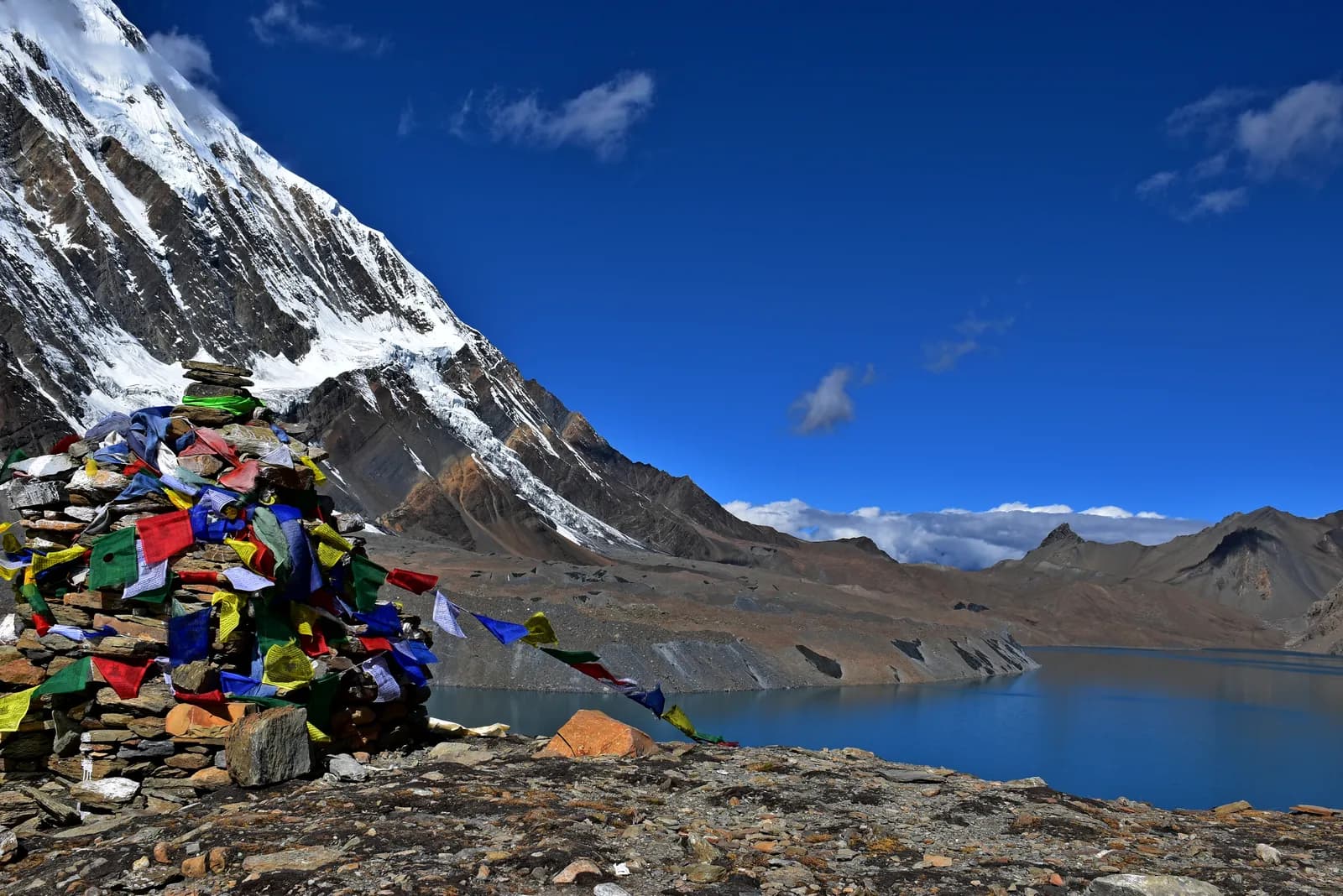
Tilicho Lake Trek
A 10-day Marsyangdi valley trek from Dharapani to Manang, then the loop to Tilicho Base Camp and the glacial lake at about 4,920 m.
- Ngày10
- Độ cao tối đa4.920 m
- Quãng đường87,8 km
- Độ cao leo5.316 m
- Độ khóKhó
- Tháng đẹp nhấtMar–May, Oct–Nov
- Giấy phép2
Lên kế hoạch chuyến đi theo lịch trình nàyTìm bạn đồng hành cho Tilicho Lake TrekXem lịch khởi hành theo tuần
Ảnh: Prabeshsdev · CC BY-SA 4.0
Hiển thị bằng tiếng Anh — chưa được dịch.
Lịch trình này là bản nháp và chưa được xác minh. Luôn xác nhận các chặng với hướng dẫn viên của bạn.
Written by FindTrekkingPartner teamĐược FindTrekkingPartner team kiểm duyệtCách chúng tôi kiểm duyệtFindTrekkingPartner
Tilicho Lake Trek là chuyến trek 10 ngày ở vùng Annapurna của Nepal, leo lên độ cao 4.920 m. Trekker nước ngoài có thể tìm bạn đồng hành cho chuyến này trên FindTrekkingPartner bằng cách đăng chuyến đi kèm ngày đi, ngân sách và tốc độ. Các kết nối được giữ riêng tư cho đến khi cả hai trekker đồng ý, và dịch vụ này miễn phí. Ở mức giá tầm trung, một hướng dẫn viên có giấy phép tốn khoảng 63 USD mỗi người trong 10 ngày khi bốn trekker chia sẻ, so với 250 USD cho một trekker đi một mình. Các mùa đẹp nhất là Mar–May, Oct–Nov. Trên thực tế, ở đây bắt buộc có hướng dẫn viên có giấy phép: theo các nhà điều hành năm 2026, quy định tháng 4 năm 2023 của Cục Du lịch Nepal (Nepal Tourism Board) được thực thi tại các trạm kiểm soát ở vườn quốc gia và khu bảo tồn, trong đó Langtang nghiêm ngặt nhất và Annapurna cũng kiểm tra (kiểm tra ngày 19 tháng 10 năm 2026). Hãy thuê hướng dẫn viên qua công ty lữ hành đã đăng ký và xác nhận với họ. Xác minh lần cuối: 21 tháng 10, 2026. Nguồn: Cục Du lịch Nepal (Nepal Tourism Board), DNPWC, Cục Xuất nhập cảnh.
Nguồn:Department of Immigration, NepalNepal Tourism BoardDepartment of National Parks and Wildlife Conservation
Tìm bạn đồng hành cho Tilicho Lake Trek
- Tìm bạn đồng hành cho Tilicho Lake Trek4 chuyến đi đang mở
- Tìm bạn đồng hành cho Annapurna Base Camp Trek25 chuyến đi đang mở
- Tìm bạn đồng hành cho Annapurna Circuit Trek4 chuyến đi đang mở
- Tìm bạn đồng hành cho Poon Hill Trek (Ghorepani)3 chuyến đi đang mở
- Tìm bạn đồng hành cho Mardi Himal Trek27 chuyến đi đang mở
- Tìm bạn đồng hành cho Khopra Ridge TrekChưa có chuyến đi đang mở
Tổng quan
Khởi hành từ Kathmandu10 ngày · tối đa 4.920 m
Mùa đẹp nhất: Mar–May, Oct–Nov · Giấy phép: Annapurna Conservation Area entry permit, TIMS card where required
Tilicho Lake is a glacial lake in Manang District, at about 4,920 m in our route data, reached by a side trip from Manang that has become a trek in its own right. This 10-day plan drives from Kathmandu to Dharapani, walks up the Marsyangdi valley through Chame, Upper Pisang and Ngawal to Manang, rests there for a day, then loops out to Khangsar, Tilicho Base Camp (about 4,140 m) and the lake before returning to Manang, where the trek ends. It is a serious high-altitude trek: the climb from Base Camp to the lake is about 800 m on loose scree, and a landslide zone between Shree Kharka and Base Camp is open but risky, so you cross early and take local advice. It suits fit walkers who have already acclimatised well in Manang and who want a guide for the exposed stretch.
What the trek is like
The first five days follow the same valley as the Annapurna Circuit, from wet forest and waterfalls below Chame to drier, Tibetan-style villages with chortens, mani walls and apple orchards. The high trail through Ghyaru and Ngawal gives long views of Annapurna II, Annapurna III, Gangapurna and Tilicho Peak. Beyond Manang the country turns bare and quiet. Lodges at Khangsar and Shree Kharka are simple and Base Camp is basic, with cold nights, short menus and limited charging, so bring a warm sleeping bag and cash.
How it is built
We model Tilicho as a stand-alone route that shares its approach with the Circuit: it uses the same road-and-trail stages as far as Manang and then adds the loop. Many trekkers instead add the lake as two or three extra days on the Circuit itself; if you want to carry on over Thorong La at 5,416 m afterwards, see the Annapurna Circuit route. Altitudes for Khangsar and Shree Kharka differ by more than 100 m between published itineraries, so treat the figures here as approximate and confirm the stages with your guide in Manang.
Permits, guide and season
You need an Annapurna Conservation Area entry permit and a TIMS card where required. The guide rule as we last checked it is this: a licensed guide through a registered agency is required in restricted areas (Department of Immigration) and, under the Nepal Tourism Board rule of April 2023, in national parks and conservation areas, where 2026 operator reports say checkpoints enforce it in Annapurna and Langtang but not in Khumbu (checked 19 October 2026). Tilicho is inside the conservation area, and the landslide section makes a guide sensible in any case. The best windows are March to May and October to November; snow can block the high sections in early spring and late autumn.
Sharing the trip
A guide and porter for the extra days are shared costs, which is why this route suits a small group. Post your dates, then agree the plan, turnaround time and what happens if someone has symptoms at altitude before you leave Manang.
Điểm nổi bật
- Tilicho Lake at about 4,920 m
- Ghyaru and Ngawal high trail
- Manang acclimatisation day
- Tilicho Base Camp (about 4,140 m)
- Landslide section crossed at first light
Bản đồ lộ trình
Dữ liệu lộ trình từ OpenStreetMap, nhóm chúng tôi chưa kiểm tra. Hãy dùng để lên kế hoạch, không dùng để dẫn đường.
Từng ngày
Bạn ngủ cao hơn đêm trước 810 m, vượt mức khuyến nghị thông thường là 500 m. Hãy đi chậm, uống nhiều nước và chú ý các dấu hiệu đau đầu hoặc buồn nôn.
Walk up the Marsyangdi valley through Bagarchhap, Danaque and Timang, where Manaslu and Peri Himal appear to the north. The path follows the road in places and keeps to the river in others; the forest of pine and oak thins as you climb. Chame, at 2,670 m, is the headquarters of Manang district and has a bank machine, shops and hot springs a short walk from the village. The air is thinner here, and the first views of Lamjung Himal and Annapurna II appear. Rest and watch the evening light on the peaks.
Bạn ngủ cao hơn đêm trước 630 m, vượt mức khuyến nghị thông thường là 500 m. Hãy đi chậm, uống nhiều nước và chú ý các dấu hiệu đau đầu hoặc buồn nôn.
Continue along the Marsyangdi, crossing to Bhratang and walking through a dry pine forest below the huge curved rock face of Paungda Danda. The valley opens at Dhikur Pokhari, with its views of Annapurna II, and the trail climbs to Upper Pisang, at 3,300 m, a village of stone houses above the road. The village has a small monastery and wide views. The landscape is now Tibetan in character, with chortens, prayer flags and apple orchards. Decide here whether to take the high trail through Ghyaru tomorrow; it is worth the effort.
Take the upper route from Upper Pisang, a steep climb through juniper to Ghyaru, at about 3,700 m, and onward along the ridge to Ngawal at 3,600 m. The path is one of the finest on the circuit: Annapurna II, Annapurna III, Gangapurna and Tilicho Peak fill the view south, and you can see the entire Manang valley below. The villages are old and the houses are stacked up the hillside. The lower route through Humde is faster but less scenic. The altitude gain is modest, but the path is steep, so go slowly and keep your water close.
Descend gently from Ngawal to Braka, pass Mugje, and walk into Manang, at 3,540 m, via the airstrip at Humde. Manang is a Tibetan-influenced village with stone alleys, bakeries and a small cinema, and the view of Gangapurna and Annapurna III from the lodges is spectacular. In the afternoon, visit the Himalayan Rescue Association post, which gives a talk on altitude sickness in the trekking seasons. It is a short day and a chance to rest, wash your clothes and explore. Drink water throughout, and watch for headaches.
Spend a full day in Manang before heading higher. Walk up to the viewpoint above Gangapurna Lake or climb toward Ice Lake (Kicho Tal) at about 4,600 m, then come back down to sleep at 3,540 m. The Tilicho loop takes you above 4,900 m, so treat this as the first half of your preparation, not a spare day. Visit the Himalayan Rescue Association post for its altitude talk, ask lodge owners and your guide how the trail beyond Shree Kharka looks this week, and settle on a turnaround time for the lake. If you had headaches or poor sleep here, stay another night or skip the lake.
Leave Manang for Khangsar, a small village above the Marsyangdi on the trail that branches toward Tilicho. Expect roughly four to six hours depending on whether you stop at Khangsar or press on to Shree Kharka, which sits a little higher; published itineraries give Khangsar at about 3,734 to 3,756 m. The country is drier and barer than the main valley, with long views back to Gangapurna and the Annapurna wall. Keep the day short and sleep low enough that the next climb feels manageable. Pay attention to how you feel, as tomorrow takes you past the landslide section and above 4,100 m.
Today you pass Shree Kharka and reach Tilicho Base Camp at about 4,140 m, a short day by distance but a serious one. Between Shree Kharka and Base Camp the path crosses a landslide zone that operators describe as open but risky, with wind and falling stones building later in the morning. Cross early, keep spacing between walkers, follow your guide and be ready to turn back if it looks worse than reported. Phone signal is patchy here. Base Camp lodging is basic and nights are cold, so arrive with enough time to warm up, eat and drink well and go to bed early.
Bạn ngủ cao hơn đêm trước 780 m, vượt mức khuyến nghị thông thường là 500 m. Hãy đi chậm, uống nhiều nước và chú ý các dấu hiệu đau đầu hoặc buồn nôn.
Start before dawn with a headlamp for the climb of about 800 m on loose scree to Tilicho Lake, listed at about 4,920 m in our route data. Go slowly, drink often and agree a turnaround time with your guide before you leave, because wind builds through the morning and the scree is unpleasant in a gale. At the top you look over a large, cold, blue lake in a bare glacial cirque with snow peaks around it, so plan time for photos and a hot drink if the lodge there is open. Descend carefully and aim to be back at Base Camp for an early-afternoon lunch and a second night at 4,140 m.
Walk back down toward Manang at 3,540 m, crossing the landslide section again, so start early and keep the same discipline as on the way up. Operators vary on how they split the return: some go straight back, others sleep at Shree Kharka or Khangsar. Agree it with your guide the evening before, based on how the group feels and what the trail looks like. In Manang you rejoin the main Circuit trail; from here you can continue toward Yak Kharka and Thorong La if you have the time and are well, or head back down the Marsyangdi valley by road.
Thích nghi độ cao
Độ cao nơi ngủ từng đêm. Các cột màu đỏ cao hơn đêm trước hơn 500 m; ngày nghỉ được đánh dấu.
- Độ cao nơi ngủ
- Tăng trên 500 m
- Ngày nghỉ
Chi phí
Chi phí trọn gói ước tính cho mỗi người: nhà trọ và ăn uống theo độ cao, di chuyển, giấy phép, hướng dẫn viên và porter. Càng nhiều người trekking chia chung hướng dẫn viên và porter, mỗi người trả càng ít. Tính đến tháng 10 năm 2026.
| Phong cách | 1 người trekking chia chung | 2 người trekking chia chung | 4 người trekking chia chung |
|---|---|---|---|
| Tiết kiệm | 510 US$–730 US$* | 400 US$–580 US$* | 350 US$–510 US$* |
| Tầm trung | 1.000 US$–1.500 US$* | 680 US$–980 US$* | 550 US$–800 US$* |
| Thoải mái | 1.050 US$–1.600 US$* | 830 US$–1.250 US$* | 710 US$–1.050 US$* |
Chia chung hướng dẫn viên, tiết kiệm tiền
Ở mức tầm trung, một người trekking một mình trả khoảng 1.000 US$–1.500 US$; bốn người chia chung một hướng dẫn viên và hai porter trả khoảng 550 US$–800 US$ mỗi người (rẻ hơn 46% ở đầu trên của khoảng giá).
Chi tiết cho 2 người trekking chia chung
| Khoản mục | Tiết kiệm | Tầm trung | Thoải mái |
|---|---|---|---|
| Nhà trọ và ăn uống | 250 US$–350 US$ | 310 US$–450 US$ | 390 US$–560 US$ |
| Di chuyển | 10 US$–50 US$ | 140 US$–230 US$ | 140 US$–230 US$ |
| Giấy phép | 30 US$–40 US$ | 30 US$–40 US$ | 30 US$–40 US$ |
| Hướng dẫn viên | 100 US$–150 US$ | 100 US$–150 US$ | 100 US$–150 US$ |
| Porter | — | 70 US$–130 US$ | 150 US$–260 US$ |
Tiết kiệm dùng phương tiện công cộng và không có porter; tầm trung chia một porter cho hai người trekking và dùng xe riêng; thoải mái cho mỗi người một porter. Hướng dẫn viên được tính khi bắt buộc hoặc khi phong cách là tầm trung hay thoải mái.
Nhà trọ và ăn uống mỗi đêm (phòng và một bữa dal bhat)
1 đêm Below 2,500 m: phòng 2 US$–6 US$, dal bhat 4 US$–7 US$ · 7 đêm 2,500 to 3,800 m: phòng 4 US$–9 US$, dal bhat 5 US$–9 US$ · 2 đêm Above 3,800 m: phòng 10 US$–15 US$, dal bhat 10 US$–12 US$
Phí giấy phép (nguồn chính thức)
Chưa bao gồm
Không tìm thấy giá công bố cho: Besisahar to Dharapani jeep; Manang to Besisahar jeep. Các tổng có dấu * chưa tính những khoản này; hãy hỏi công ty du lịch của bạn.
Nguồn chi phí
- PriceNepal: Nepal Travel Cost Guide 2026 (2026-05-14)
- Third Rock Adventures: Nepal trek budget planner (2026-05-09)
- Himalayan Partner: Guide and porter price in Nepal 2026 (2026-02-10)
- Shikhar Adventure: Annapurna Circuit trek cost (2026-02-03)
Ước tính từ hướng dẫn của nhà điều hành, không phải báo giá. Tiền boa, bảo hiểm, đồ dùng và khách sạn ở Kathmandu không được tính; USD theo tỷ giá của nền tảng.
Ảnh
Câu hỏi thường gặp
About 4,919 m according to Wikipedia, with another source giving 4,949 m; our route data uses about 4,920 m. Tilicho Base Camp is usually given as about 4,140 m.
One section between Shree Kharka and Base Camp crosses a landslide zone that operators describe as open but risky, with wind and rockfall later in the morning. Cross early, follow your guide and check the current condition in Manang.
Our route data lists an Annapurna Conservation Area entry permit and a TIMS card where required, the same as the Annapurna Circuit. Ask your agency whether anything else applies.
Tilicho is inside the Annapurna Conservation Area, where 2026 operator reports say checkpoints enforce the guide rule (checked 19 October 2026). The landslide section makes a guide sensible regardless.
March to May and October to November, the same windows as the Circuit. Snow can block the high sections in early spring and late autumn.
Yes. Many trekkers add it as two or three extra days from Manang and then continue toward Thorong La; this route covers the lake as its own trek.
Nguồn
Dọc đường mòn
Chỗ ở, hỗ trợ y tế, nước và cảnh đẹp trong mỗi ngày của lộ trình.
1. Kathmandu → Dharapani
- Tribhuvan International Airport · Sân bay & giao thông · 1.340 m
2. Dharapani → Chame
- Hayenga Waterfall · Thiên nhiên · 2.053 m
- Viewpoint · Điểm ngắm cảnh · 1.840 m
- ACAP Safe Drinking Water Station · Tiện ích · 2.162 m
- Hotel Four Seasons · Chỗ ở · 2.676 m
- Moonlight Hotel · Chỗ ở · 2.676 m
- Hotel Manasulu View · Chỗ ở · 2.678 m
- Trekkers Holiday Holtel · Chỗ ở · 2.678 m
Show all 23 places
- Hayenga Waterfall · Thiên nhiên · 2.053 m
- Manaslu Hotel Restaurant · Chỗ ở · 1.820 m
- Hayat Guest House · Chỗ ở · 1.818 m
- Viewpoint · Điểm ngắm cảnh · 1.840 m
- Peaceful Hotel · Chỗ ở · 1.876 m
- Gyasumda Hotel & Restaurant · Chỗ ở · 1.877 m
- Dafne Hotel · Chỗ ở · 1.881 m
- Marsyangdi Lodge · Chỗ ở · 2.076 m
- Pasang · Chỗ ở · 2.082 m
- Eco Holiday home · Chỗ ở · 2.081 m
- Tilicho Hotel · Chỗ ở · 2.099 m
- ACAP Safe Drinking Water Station · Tiện ích · 2.162 m
- Hotel Manaslu · Chỗ ở · 2.172 m
- Mt Kailash · Chỗ ở · 2.200 m
- Potala · Chỗ ở · 2.208 m
- Happy Home Cottage · Chỗ ở · 2.601 m
- Tibet Lhasa Guest House · Chỗ ở · 2.601 m
- Snowland Hotel · Chỗ ở · 2.602 m
- Hotel Four Seasons · Chỗ ở · 2.676 m
- Moonlight Hotel · Chỗ ở · 2.676 m
- Hotel Manasulu View · Chỗ ở · 2.678 m
- Trekkers Holiday Holtel · Chỗ ở · 2.678 m
- Potala Guest House & Restaurant · Chỗ ở · 2.680 m
3. Chame → Upper Pisang
- Chame Hot springs · Thiên nhiên · 2.697 m
- Manang District Hospital · Y tế · 2.732 m
- Viewpoint · Điểm ngắm cảnh · 2.516 m
- Drinking Water · Tiện ích · 3.801 m
- Hotel Nirvana · Chỗ ở · 3.281 m
- Hotel Narbulinka Pisang · Chỗ ở · 3.291 m
- Hotel Royal Nyeshang · Chỗ ở · 3.290 m
- Hotel Alobar 3300 · Chỗ ở · 3.288 m
Show all 24 places
- Hotel Marshyangdi Mandala · Chỗ ở · 2.664 m
- Chame Hot springs · Thiên nhiên · 2.697 m
- Royal Garden Hotel · Chỗ ở · 2.670 m
- Manang District Hospital · Y tế · 2.732 m
- Sangso Guest House · Chỗ ở · 2.673 m
- White Stupa · Chỗ ở · 2.690 m
- Happy Guest House · Chỗ ở · 2.696 m
- New Mount View · Chỗ ở · 2.774 m
- Talekhu · Chỗ ở · 2.776 m
- Campsite · Chỗ ở · 2.694 m
- Viewpoint · Điểm ngắm cảnh · 2.516 m
- Drinking Water · Tiện ích · 3.801 m
- Sworgadwari Hotel & Restaurant · Chỗ ở · 3.188 m
- Gangapurna · Chỗ ở · 3.186 m
- Kamala · Chỗ ở · 3.197 m
- Maya Hotel & Restaurant · Chỗ ở · 3.186 m
- Hotel Nirvana · Chỗ ở · 3.281 m
- Hotel Narbulinka Pisang · Chỗ ở · 3.291 m
- Hotel Royal Nyeshang · Chỗ ở · 3.290 m
- Hotel Alobar 3300 · Chỗ ở · 3.288 m
- Hilltop Hotel Upper Pisang · Chỗ ở · 3.298 m
- Happiness Guest house · Chỗ ở · 3.303 m
- Royal mountain · Chỗ ở · 3.310 m
- Hotel Mountain Bridge · Chỗ ở · 3.326 m
4. Upper Pisang → Ngawal
- Viewpoint · Điểm ngắm cảnh · 3.301 m
- Green lake · Thiên nhiên · 3.262 m
- Water tap (Disfunctional July 2019) · Tiện ích · 3.449 m
- Drinking Water · Tiện ích · 3.603 m
- Nagwal Cottage · Chỗ ở · 3.658 m
- Himalaya Hotel · Chỗ ở · 3.657 m
- New Annapurna · Chỗ ở · 3.651 m
- Tibet Guest House & Restaurant · Chỗ ở · 3.671 m
Show all 18 places
- Campsite · Chỗ ở · 3.422 m
- Viewpoint · Điểm ngắm cảnh · 3.301 m
- Hotel Mringkyo · Chỗ ở · 3.266 m
- Green lake · Thiên nhiên · 3.262 m
- Camping · Chỗ ở · 3.271 m
- Water tap (Disfunctional July 2019) · Tiện ích · 3.449 m
- Drinking Water · Tiện ích · 3.603 m
- Pema guest house · Chỗ ở · 3.697 m
- Yak Ru Hotel · Chỗ ở · 3.702 m
- Gorkhali Hotel · Chỗ ở · 3.704 m
- Annapurna Hotel · Chỗ ở · 3.716 m
- New Annapurna guest house · Chỗ ở · 3.721 m
- Hôtel Mount View · Chỗ ở · 3.665 m
- Nagwal Cottage · Chỗ ở · 3.658 m
- Himalaya Hotel · Chỗ ở · 3.657 m
- New Annapurna · Chỗ ở · 3.651 m
- Manang Airport · Sân bay & giao thông · 3.353 m
- Tibet Guest House & Restaurant · Chỗ ở · 3.671 m
5. Ngawal → Manang
- Hotel Manang · Chỗ ở · 3.533 m
- Hotel Mountain Lake · Chỗ ở · 3.537 m
- Hotel Nilgiri · Chỗ ở · 3.539 m
- HRA Manang Aid Post · Y tế · 3.540 m
- Hotel Yeti · Chỗ ở · 3.537 m
- Safe Drinking Water Station · Tiện ích · 3.550 m
- ACAP Safe Drinking Water Station · Tiện ích · 3.550 m
- Manang Health Post · Y tế · 3.558 m
Show all 25 places
- Buddha Kitchen Hotel · Chỗ ở · 3.658 m
- Royal Nyeshyang · Chỗ ở · 3.655 m
- Ngawal · Chỗ ở · 3.673 m
- Shanti Hotel · Chỗ ở · 3.675 m
- Viewpoint · Điểm ngắm cảnh · 3.632 m
- Namaste trekkers homestay · Chỗ ở · 3.485 m
- Hotel Manang · Chỗ ở · 3.533 m
- Hotel Mountain Lake · Chỗ ở · 3.537 m
- Hotel Nilgiri · Chỗ ở · 3.539 m
- HRA Manang Aid Post · Y tế · 3.540 m
- Hotel Yeti · Chỗ ở · 3.537 m
- Tilicho Hotel & Restaurant · Chỗ ở · 3.538 m
- Safe Drinking Water Station · Tiện ích · 3.550 m
- Hotel Marsyangdi · Chỗ ở · 3.545 m
- Hotel Royal Manang · Chỗ ở · 3.552 m
- Moon Light Hotel & Restaurant · Chỗ ở · 3.550 m
- Yak Hotel · Chỗ ở · 3.544 m
- ACAP Safe Drinking Water Station · Tiện ích · 3.550 m
- Moon Light hotel · Chỗ ở · 3.550 m
- Alpine home · Chỗ ở · 3.544 m
- Hotel North Pole · Chỗ ở · 3.550 m
- Gangapurna Hotel Lodge · Chỗ ở · 3.543 m
- Manang Health Post · Y tế · 3.558 m
- Ghyalchan & Sister · Chỗ ở · 3.543 m
- Ghale guest house · Chỗ ở · 3.544 m
6. Manang
Chưa có gì được vẽ trên bản đồ cho ngày này.Chưa có gì được vẽ trên bản đồ cho ngày này.7. Manang → Khangsar
- Viewpoint · Điểm ngắm cảnh · 3.594 m
- Path Manang - Khangsar · Điểm ngắm cảnh · 3.663 m
- Khangsar health post · Y tế · 3.753 m
- Norbu Ling Hotel · Chỗ ở · 3.747 m
- Maya Hotel · Chỗ ở · 3.745 m
- Soni homestay · Chỗ ở · 3.753 m
- Khangsar Home · Chỗ ở · 3.754 m
Show all 9 places
- Thorong La · Chỗ ở · 3.549 m
- Manaslu · Chỗ ở · 3.554 m
- Viewpoint · Điểm ngắm cảnh · 3.594 m
- Path Manang - Khangsar · Điểm ngắm cảnh · 3.663 m
- Khangsar health post · Y tế · 3.753 m
- Norbu Ling Hotel · Chỗ ở · 3.747 m
- Maya Hotel · Chỗ ở · 3.745 m
- Soni homestay · Chỗ ở · 3.753 m
- Khangsar Home · Chỗ ở · 3.754 m
8. Khangsar → Tilicho Base Camp
- Viewpoint · Điểm ngắm cảnh · 3.905 m
- Mountain eco cottage · Chỗ ở · 4.066 m
- Hotel mountain view · Chỗ ở · 4.130 m
- New Zambala · Chỗ ở · 4.135 m
- Sweet Home · Chỗ ở · 4.139 m
Show all 7 places
- Viewpoint · Điểm ngắm cảnh · 3.905 m
- Mountain eco cottage · Chỗ ở · 4.066 m
- Himalayan Hotel · Chỗ ở · 4.067 m
- possible Campsite · Chỗ ở · 4.222 m
- Hotel mountain view · Chỗ ở · 4.130 m
- New Zambala · Chỗ ở · 4.135 m
- Sweet Home · Chỗ ở · 4.139 m
9. Tilicho Base Camp
- Hotel Khangsar Kang · Chỗ ở · 4.136 m
- New Hotel Moon Lake · Chỗ ở · 4.137 m
- Khangsar health post · Y tế · 4.148 m
- Viewpoint · Điểm ngắm cảnh · 4.423 m
10. Tilicho Base Camp → Manang
- Hotel New Himalayan · Chỗ ở · 4.137 m
- Hotel Himalayan · Chỗ ở · 4.139 m
- Hotel Basecamp Inn · Chỗ ở · 4.136 m
- Stream · Tiện ích · 4.231 m
- Viewpoint · Điểm ngắm cảnh · 3.946 m
- Drinking Water · Tiện ích · 3.743 m
- Xchongla Homestay · Chỗ ở · 3.547 m
Show all 15 places
- Hotel New Himalayan · Chỗ ở · 4.137 m
- Hotel Himalayan · Chỗ ở · 4.139 m
- Hotel Basecamp Inn · Chỗ ở · 4.136 m
- New Norbu Ling Hotel · Chỗ ở · 4.131 m
- New Tilicho Lake Base Camp Hotel · Chỗ ở · 4.137 m
- Stream · Tiện ích · 4.231 m
- Blue Sheep · Chỗ ở · 4.178 m
- Hotel Tilicho Peak and Restaurant · Chỗ ở · 4.070 m
- Viewpoint · Điểm ngắm cảnh · 3.946 m
- Laxmi Guest House · Chỗ ở · 3.751 m
- Himalchuli Laxmi Hotel · Chỗ ở · 3.747 m
- Drinking Water · Tiện ích · 3.743 m
- Hotel Mountain Yak · Chỗ ở · 3.741 m
- Potala · Chỗ ở · 3.741 m
- Xchongla Homestay · Chỗ ở · 3.547 m
Xác minh lần cuối ngày 21 thg 10, 2026Báo cáo thông tin lỗi thời