

Drive from Kathmandu to Dhap Bazaar, a ridge settlement at about 2,900 m, which takes seven to nine hours depending on the source and the state of the road. KimKim lists a lunch stop at Ghurmi on the way. The road climbs through hill towns and terraces, and your first night is at a teahouse in Dhap. Dhap's height of about 2,900 m, which most operators give, is in line with the elevation model, which gives about 3,000 m. Use the evening to repack, check your guide's plan for the morning, and rest, because the next days start early.
Pikey Peak Trek
A six-day trek in Solu that climbs from Dhap Bazaar through Jhapre to Pikey Peak (4,065 m) for sunrise over Everest, then descends to Junbesi and Phaplu.
- दिन6
- अधिकतम उचाइ४,०६५ मि
- दूरी४८.६ कि.मि.
- उकालो२,२६१ मि
- कठिनाइमध्यम
- उत्तम महिनाMar–May, Sep–Nov
- अनुमतिपत्र3
यो यात्रा तालिकासहित ट्रिपको योजना बनाउनुहोस्Pikey Peak Trek का लागि साथी खोज्नुहोस्हप्ताअनुसार प्रस्थान हेर्नुहोस्
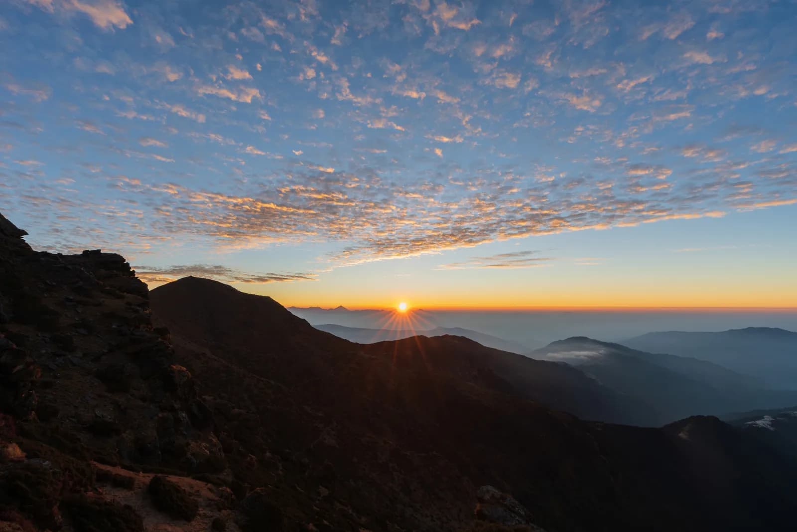
फोटो: Sunuwargr · CC BY-SA 4.0
अंग्रेजीमा देखाइएको — अझै अनुवाद भएको छैन।
यो यात्रा तालिका मस्यौदा हो र अझै प्रमाणित भएको छैन। चरणहरू सधैं आफ्नो गाइडसँग पुष्टि गर्नुहोस्।
Written by FindTrekkingPartner teamFindTrekkingPartner team द्वारा समीक्षितहामी कसरी समीक्षा गर्छौंFindTrekkingPartner
Pikey Peak Trek नेपालको Solu क्षेत्रमा पर्ने 6 दिनको ट्रेक हो, जुन ४,०६५ मिटरसम्म उक्लिन्छ। विदेशी ट्रेकरहरूले आफ्नो मिति, बजेट र गतिसहित ट्रिप पोस्ट गरेर FindTrekkingPartner मा यसका लागि साथी खोज्न सक्छन्। दुवै ट्रेकर सहमत नभएसम्म म्याचहरू निजी रहन्छन्, र सेवा निःशुल्क छ। मध्यम स्तरको दरमा, चार जना ट्रेकरले बाँड्दा 6 दिनको लागि इजाजतपत्रप्राप्त गाइडको खर्च प्रति व्यक्ति लगभग USD ५६ पर्छ, जबकि एक्लै जाँदा USD २२४ पर्छ। उत्तम मौसमहरू Mar–May, Sep–Nov हुन्। यहाँ व्यवहारमा इजाजतपत्रप्राप्त गाइड आवश्यक छ: २०२६ का सञ्चालकहरूका अनुसार नेपाल पर्यटन बोर्डको अप्रिल २०२३ को नियम राष्ट्रिय निकुञ्ज र संरक्षण क्षेत्रका चेकपोइन्टहरूमा लागू गरिन्छ, जसमा लाङटाङ सबैभन्दा कडा छ र अन्नपूर्णमा पनि जाँच हुन्छ (१९ अक्टोबर २०२६ मा जाँचिएको)। दर्ता भएको एजेन्सीमार्फत गाइड लिनुहोस् र उनीहरूसँग पुष्टि गर्नुहोस्। पछिल्लो पटक पुष्टि गरिएको: २०२६ अक्टोबर १९। स्रोतहरू: नेपाल पर्यटन बोर्ड, DNPWC, अध्यागमन विभाग।
स्रोतहरू:Department of Immigration, NepalNepal Tourism BoardDepartment of National Parks and Wildlife Conservation
Pikey Peak Trek का लागि साथी खोज्नुहोस्
- Pikey Peak Trek का लागि साथी खोज्नुहोस्अहिलेसम्म कुनै खुला ट्रिप छैन
- Dudh Kunda Trek का लागि साथी खोज्नुहोस्अहिलेसम्म कुनै खुला ट्रिप छैन
परिचय
Kathmandu बाट सुरु६ दिन · अधिकतम ४,०६५ मि
उत्तम मौसम: Mar–May, Sep–Nov · अनुमतिपत्र: No restricted-area permit, Pikey Peak is outside Sagarmatha National Park, Ask your agency about any local trek card
The Pikey Peak trek is a six-day walk through the Solu part of Solukhumbu to a 4,065 m summit that gives one of the best sunrise views of Everest and the Himalaya from outside the Khumbu. A seven to nine hour drive from Kathmandu reaches Dhap Bazaar on the ridge, and the walk then goes through Jhapre and Pikey Base Camp to the summit, down to Junbesi, and along the Junbesi Khola to Phaplu, from where a drive of eight to nine hours returns to the city. The walking is about 48 km with 2,260 m of climbing and 2,790 m of descent. The trail is quieter than the Everest base camp route, passes through oak and rhododendron forest and yak pasture, and has lodges at every stop. The walk needs no flight, no restricted-area permit and no special gear beyond warm clothes for the summit sunrise.
The plan follows a KimKim itinerary and a Nepal Traveller article, which agree on the stops and the Dhap start, and it uses their heights for Jhapre, the base camp and Junbesi only where they match the elevation model. The first day on the road is long, and the second day follows a ridge road, so the real climb starts on day three. The best months are March to May and September to November. Pikey is not a restricted area and lies outside Sagarmatha National Park, so no flight and no special permit are needed.
Difficulty and fitness
The trek is moderate. The longest day is the descent from Pikey Base Camp to Junbesi, about 15 km and 1,670 m down, and the climb from Jhapre to the base camp is about 870 m. The summit climb is short but cold and dark. Good boots and trekking poles help on the descent.
Budget notes
The costs section uses Nepal-wide lodge and meal ranges by altitude, with a guide, a porter and road transport. Fares for the drives to and from Dhap and Phaplu are shown as lines to check, since we found no published prices.
What to pack
A down jacket, hat and gloves for the summit sunrise, a headlamp, rain gear, a warm sleeping bag and water treatment. Lodges give blankets, but nights at Pikey Base Camp, at about 3,640 m, are cold.
मुख्य आकर्षण
- Sunrise from Pikey Peak at 4,065 m, with Everest and the Khumbu range in view
- Rhododendron forest, yak pasture and the Sherpa and Rai villages of Solu
- Junbesi and the Thubten Choling monastery
- A quieter alternative to the Everest base camp trail
- A road start and finish: no flight is needed
मार्ग नक्सा
मार्गको डेटा OpenStreetMap बाट लिइएको हो, हाम्रो टोलीले अझै जाँचेको छैन। योजना बनाउन प्रयोग गर्नुहोस्, नेभिगेसनका लागि होइन।
दिनदिनको विवरण
Walk about 9.4 km from Dhap Bazaar to Jhapre, four to five hours, through Sigane along a ridge road with small ups and downs. It is the easiest walking day: the climb is only 220 m, with 370 m of descent, and most of it is on a motor road, which operators describe as a forest road. Jhapre is at about 2,815 m according to KimKim and Nepalgram, and the lodges lie in a cluster below Pikey. Spend the afternoon resting, and eat early, because the next day is much longer and steeper.
तपाईं अघिल्लो रातभन्दा ८२५ मि माथि सुत्नुहुन्छ, जुन सामान्य ५०० मिटरको मार्गदर्शनभन्दा बढी हो। बिस्तारै हिँड्नुहोस्, प्रशस्त पानी पिउनुहोस् र टाउको दुखाइ वा वाकवाकी भए ध्यान दिनुहोस्।
A day of 13 km and 870 m of climbing, five to seven hours, climbs from Jhapre along the ridge, through rhododendron and yak pasture, to Pikey Base Camp at about 3,640 m. KimKim lists lunch at Lhamuje and a time of five to six hours, and Third Rock Adventures gives six to seven. The path is mostly a footpath, with some road, and views open as you gain height. The lodge at the base camp is simple, and the night is cold. Eat well and go to bed early, because the summit is for sunrise.
Rise before dawn for the climb of about 3 km and 400 m to the summit at 4,065 m, about 1.5 to 2 hours in the dark with a headlamp, by our estimate. At sunrise, Everest and the Khumbu peaks stand above the ridges, and Hillary is said to have favoured the view. Come back to the base camp for breakfast, then walk about 12 km and 1,670 m down to Junbesi at about 2,680 m, the longest day: seven to eight hours with the summit, according to our estimate and an operator that gives eight. The route passes Jasmane Bhanjyang and forest.
Walk about 11 km from Junbesi to Phaplu in four to five hours, mostly downhill along the Junbesi Khola, with a few climbs. Phaplu is at about 2,400 m by KimKim and OpenStreetMap, and the elevation model puts it near 2,490 m. If you have spare time and energy, the Thubten Choling monastery lies a few kilometres north of Junbesi, and a round trip takes about three hours. Your lodge in Phaplu is close to the airstrip, and the town is the district's road and air hub, so it is a comfortable last night in the hills.
Drive from Phaplu to Kathmandu, a journey of about eight to nine hours. The road retraces much of the way to Kathmandu through Okhaldhunga district and over several ridges, and it is bumpy in places. Some trekkers take the short flight from Phaplu instead if the weather allows, which saves most of the day, but flights are often cancelled in cloud, so keep the road as your fallback. If you have a flight out of Nepal, leave a spare day before it.
अनुकूलन
रातैपिच्छे सुत्ने उचाइ। रातो पट्टीहरू अघिल्लो रातभन्दा ५०० मिटरभन्दा बढी चढेका हुन्; आराम दिन चिन्ह लगाइएको छ।
- सुत्ने उचाइ
- ५०० मिटरभन्दा बढी चढाइ
- आराम दिन
कति खर्च लाग्छ
प्रति व्यक्ति अनुमानित सबै-समेतको खर्च: उचाइअनुसार लज र खाना, यातायात, अनुमतिपत्र, र गाइड तथा पोर्टर। जति धेरै ट्रेकरले गाइड र पोर्टर बाँड्छन्, प्रत्येकले त्यति कम तिर्छन्। २०२६ अक्टोबर सम्मको अनुसार।
| शैली | १ ट्रेकर | २ ट्रेकर बाँडेर | ४ ट्रेकर बाँडेर |
|---|---|---|---|
| किफायती | US$ १००–US$ १७०* | US$ १००–US$ १७०* | US$ १००–US$ १७०* |
| मध्यम | US$ ३५०–US$ ५६०* | US$ २५०–US$ ४००* | US$ २१०–US$ ३४०* |
| आरामदायी | US$ ४००–US$ ६३०* | US$ ३३०–US$ ५२०* | US$ २९०–US$ ४६०* |
गाइड बाँडेर पैसा बचाउनुहोस्
मध्यम स्तरमा, एक्लो ट्रेकरले करिब US$ ३५०–US$ ५६० तिर्छ; एउटा गाइड र दुई पोर्टर बाँड्ने चार ट्रेकरले प्रत्येकले करिब US$ २१०–US$ ३४० तिर्छन् (दायराको माथिल्लो छेउमा 39% कम)।
२ ट्रेकरले बाँड्दाको विवरण
| विवरण | किफायती | मध्यम | आरामदायी |
|---|---|---|---|
| लज र खाना | US$ १००–US$ १७० | US$ १४०–US$ २३० | US$ १९०–US$ ३०० |
| गाइड | — | US$ ७०–US$ १२० | US$ ७०–US$ १२० |
| पोर्टर | — | US$ ३०–US$ ६० | US$ ६०–US$ ११० |
बजेटमा सार्वजनिक यातायात र पोर्टरबिना; मध्यम स्तरमा दुई ट्रेकरबीच एक पोर्टर र निजी सवारी साधन बाँडिन्छ; आरामदायीमा प्रत्येक ट्रेकरलाई एक पोर्टर। गाइड अनिवार्य भएको ठाउँमा वा मध्यम स्तर अथवा आरामदायी शैलीमा समावेश गरिएको हुन्छ।
रातको लज र खाना (कोठा र दाल भात)
१ रात Below 2,500 m: कोठा US$ २–US$ ९, दाल भात US$ ४–US$ ७ · ४ रात 2,500 to 3,800 m: कोठा US$ ४–US$ ११, दाल भात US$ ५–US$ ११
समावेश छैन
यिनको प्रकाशित मूल्य भेटिएन: Kathmandu to Dhap Bazaar by road (return)। * चिन्ह लागेका जम्मा रकममा यी छुटेका छन्; आफ्नो एजेन्सीसँग सोध्नुहोस्। No permit applies. The return drive from Phaplu to Kathmandu is priced with the same road leg; a flight from Phaplu is an alternative with no published fare in our sources.
खर्चका स्रोतहरू
- PriceNepal: Nepal Travel Cost Guide 2026 (2026-05-14)
- Third Rock Adventures: Nepal trek budget planner (2026-05-09)
- Himalayan Partner: Guide and porter price in Nepal 2026 (2026-02-10)
- Shikhar Adventure: Annapurna Circuit trek cost (2026-02-03)
- Nepal Tourism Board: Trekking Permit (2026-10-18)
अपरेटर गाइडबाट लिइएका अनुमान हुन्, कोटेसन होइनन्। टिप, बीमा, सामान र काठमाडौंका होटल समावेश छैनन्; USD प्लेटफर्मको विनिमय दरमा।
फोटोहरू
प्रायः सोधिने प्रश्नहरू
This plan takes six days from Kathmandu to Kathmandu, with four walking days and a drive at each end. Operators sell versions of seven to eleven days, which add Kathmandu days, a side trip to Thubten Choling monastery or a night at Taksindu.
4,065 m, which is the figure on Wikipedia, on OpenStreetMap and in operator itineraries; our elevation model gives about 4,040 m. Pikey Base Camp is given as 3,585 to 3,640 m.
No restricted-area permit is needed, and the peak is outside Sagarmatha National Park, so its entry permit does not apply. Ask your agency whether any local municipality fee applies.
Yes, one common variant flies to Phaplu and walks to Junbesi and Pikey, and some plans return by air from Phaplu. Flights depend on weather, so allow spare days. Our plan drives both ways and prices road transport only.
It is a moderate trek with a high point of 4,065 m, so it suits fit beginners who accept cold mornings. The sunrise climb from the base camp is the hardest part, and the lodges give shelter at each stop.
स्रोतहरू
बाटोभरि
मार्गको हरेक दिन बास, चिकित्सा सहायता, पानी र हेर्नलायक ठाउँहरू।
1. Kathmandu → Dhap Bazaar
- त्रिभुवन अन्तर्राष्ट्रिय विमानस्थल · विमानस्थल र यातायात · १,३४० मि
2. Dhap Bazaar → Jhapre
- Magar Hotel Dhap · बास · २,९९८ मि
- Magar Hotel and Lodge · बास · २,९९७ मि
- Mountain view lodge · बास · २,६७५ मि
- Number view Lama Hotel · बास · २,८४४ मि
Show all 5 places
- Magar Hotel Dhap · बास · २,९९८ मि
- Magar Hotel and Lodge · बास · २,९९७ मि
- Mountain view lodge · बास · २,६७५ मि
- Mountain view lodge & restaurant · बास · २,६७६ मि
- Number view Lama Hotel · बास · २,८४४ मि
3. Jhapre → Pikey Base Camp
- Pikey lodge · बास · २,८४७ मि
- Guest House · बास · २,८४७ मि
- Mountain view hotel · बास · २,९१९ मि
- Lhamuje Lodge · बास · ३,४९४ मि
Show all 8 places
- Pikey lodge · बास · २,८४७ मि
- Guest House · बास · २,८४७ मि
- Mountain view hotel · बास · २,९१९ मि
- Everest view point · बास · २,९३२ मि
- Panorama View Hotel · बास · २,९२७ मि
- Himalayan Lama Hotel · बास · २,९४४ मि
- Bhulbule Lodge · बास · ३,३६९ मि
- Lhamuje Lodge · बास · ३,४९४ मि
4. Pikey Base Camp → Junbesi
- Lamjura La · प्रकृति · ३,५३० मि
- Drinking Water · उपयोगी · ३,१९५ मि
- Jumbesi Home Stay · बास · २,७४९ मि
- Sherpa Guide Lodge & Restaurant · बास · २,६९९ मि
- Apple Garden Guest House · बास · २,६८६ मि
- Ang Domi Lodge · बास · २,६९७ मि
Show all 17 places
- Peakey Yak Lodge& Restaurant · बास · ३,४९९ मि
- Pikey Everest Lodge an Restaurant · बास · ३,५०८ मि
- Lamjura La · प्रकृति · ३,५३० मि
- Drinking Water · उपयोगी · ३,१९५ मि
- Green View Hotel and Restaurant · बास · ३,१३१ मि
- Tashi Deleg Lodge · बास · ३,१७८ मि
- Shanti Chetra Lodge · बास · ३,११५ मि
- Suman Lodge · बास · ३,०३४ मि
- Jumbesi Home Stay · बास · २,७४९ मि
- Sherpa Guide Lodge & Restaurant · बास · २,६९९ मि
- Apple Garden Guest House · बास · २,६८६ मि
- Ang Domi Lodge · बास · २,६९७ मि
- Jumbesi Valley Guest House · बास · २,६८२ मि
- Ang Chhokpa’s Lodge & Restaurant · बास · २,६८९ मि
- J.B. Lodge & Restaurant · बास · २,६८४ मि
- Noryang Hotel · बास · २,७०० मि
- Zambala Guest House · बास · २,७०८ मि
5. Junbesi → Phaplu
- Phaplu Airport · विमानस्थल र यातायात · २,४६८ मि
- Phaplu Hospital · चिकित्सा · २,५०५ मि
- Hotel Dream Lodge & Restaurant · बास · २,४७२ मि
- Green Land Hotel & Lodge · बास · २,४७७ मि
- Kirat Hotel Lodge and Restaurant · बास · २,४८२ मि
- Hotel Sunshine · बास · २,४८२ मि
Show all 21 places
- Sherpa Home Stay · बास · २,७०१ मि
- Hotel Kunsal · बास · २,६८० मि
- Everest Lodge & Restaurant · बास · २,६७९ मि
- Sagarmatha Lodge & Restaurant · बास · २,६७६ मि
- Phaplu Airport · विमानस्थल र यातायात · २,४६८ मि
- Phaplu Hospital · चिकित्सा · २,५०५ मि
- Hotel Dream Lodge & Restaurant · बास · २,४७२ मि
- Green Land Hotel & Lodge · बास · २,४७७ मि
- Kirat Hotel Lodge and Restaurant · बास · २,४८२ मि
- Hotel Sunshine · बास · २,४८२ मि
- Rokding Hotel & Lodge · बास · २,४७९ मि
- Namaste Hotel & Restaurant · बास · २,४८० मि
- Hotel Phaplu Lodge & Restaurant · बास · २,४७९ मि
- Airport Hotel Lodge & Restaurant · बास · २,४७९ मि
- Bijay & Bikash Hotel · बास · २,४८१ मि
- Khumbila Hotel & Lodge · बास · २,४८१ मि
- Hotel Everest · बास · २,४८४ मि
- Thamserku Lodge & Restaurant · बास · २,४८६ मि
- Sofiya Hotel & Lodge · बास · २,४८६ मि
- Shangri-La Guest House · बास · २,४८६ मि
- Kyirmu Lodge · बास · २,४९८ मि
6. Phaplu → Kathmandu
यो दिनका लागि अहिलेसम्म केही नक्सांकन भएको छैन।यो दिनका लागि अहिलेसम्म केही नक्सांकन भएको छैन।
अन्तिम पटक २०२६ अक्टोबर १९ मा प्रमाणितपुरानो जानकारी रिपोर्ट गर्नुहोस्