

Drive by jeep from Kathmandu to Ringmu, about ten hours to Salleri and about an hour more up the hill, according to the Kathmandu Post. The road crosses several ridges and can be slowed by landslides in the monsoon. Ringmu, at about 2,800 m, is known for houses painted blue and white, and the Post's writer slept in a hotel with a wooden interior. Settle in, buy any snacks you need, and check with your guide how many days you will spend above 4,000 m. The next day is short, which helps you acclimatise.
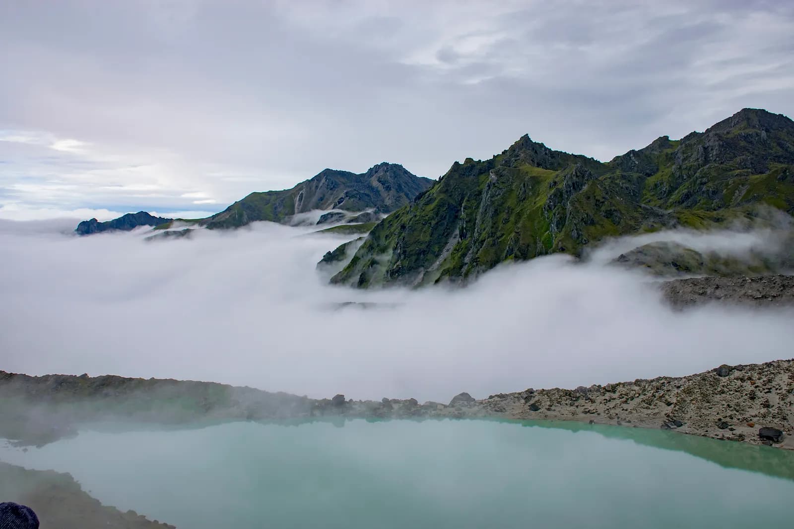
Dudh Kunda Trek
A six-day trek from Ringmu in Solu over Taksindu to Sano Beni and the sacred lake of Dudh Kunda at about 4,560 m below Numbur Himal, with a road start and finish.
- दिन6
- अधिकतम उचाइ४,५६१ मि
- दूरी३७.७ कि.मि.
- उकालो२,४३९ मि
- कठिनाइकठिन
- उत्तम महिनाMar–May, Sep–Nov
- अनुमतिपत्र3
यो यात्रा तालिकासहित ट्रिपको योजना बनाउनुहोस्Dudh Kunda Trek का लागि साथी खोज्नुहोस्हप्ताअनुसार प्रस्थान हेर्नुहोस्
फोटो: Chandra Chakradhar · CC BY-SA 4.0
अंग्रेजीमा देखाइएको — अझै अनुवाद भएको छैन।
यो यात्रा तालिका मस्यौदा हो र अझै प्रमाणित भएको छैन। चरणहरू सधैं आफ्नो गाइडसँग पुष्टि गर्नुहोस्।
Written by FindTrekkingPartner teamFindTrekkingPartner team द्वारा समीक्षितहामी कसरी समीक्षा गर्छौंFindTrekkingPartner
Dudh Kunda Trek नेपालको Solu क्षेत्रमा पर्ने 6 दिनको ट्रेक हो, जुन ४,५६१ मिटरसम्म उक्लिन्छ। विदेशी ट्रेकरहरूले आफ्नो मिति, बजेट र गतिसहित ट्रिप पोस्ट गरेर FindTrekkingPartner मा यसका लागि साथी खोज्न सक्छन्। दुवै ट्रेकर सहमत नभएसम्म म्याचहरू निजी रहन्छन्, र सेवा निःशुल्क छ। मध्यम स्तरको दरमा, चार जना ट्रेकरले बाँड्दा 6 दिनको लागि इजाजतपत्रप्राप्त गाइडको खर्च प्रति व्यक्ति लगभग USD ५६ पर्छ, जबकि एक्लै जाँदा USD २२४ पर्छ। उत्तम मौसमहरू Mar–May, Sep–Nov हुन्। यहाँ व्यवहारमा इजाजतपत्रप्राप्त गाइड आवश्यक छ: २०२६ का सञ्चालकहरूका अनुसार नेपाल पर्यटन बोर्डको अप्रिल २०२३ को नियम राष्ट्रिय निकुञ्ज र संरक्षण क्षेत्रका चेकपोइन्टहरूमा लागू गरिन्छ, जसमा लाङटाङ सबैभन्दा कडा छ र अन्नपूर्णमा पनि जाँच हुन्छ (१९ अक्टोबर २०२६ मा जाँचिएको)। दर्ता भएको एजेन्सीमार्फत गाइड लिनुहोस् र उनीहरूसँग पुष्टि गर्नुहोस्। पछिल्लो पटक पुष्टि गरिएको: २०२६ अक्टोबर १९। स्रोतहरू: नेपाल पर्यटन बोर्ड, DNPWC, अध्यागमन विभाग।
स्रोतहरू:Department of Immigration, NepalNepal Tourism BoardDepartment of National Parks and Wildlife Conservation
Dudh Kunda Trek का लागि साथी खोज्नुहोस्
- Dudh Kunda Trek का लागि साथी खोज्नुहोस्अहिलेसम्म कुनै खुला ट्रिप छैन
- Pikey Peak Trek का लागि साथी खोज्नुहोस्अहिलेसम्म कुनै खुला ट्रिप छैन
परिचय
Kathmandu बाट सुरु६ दिन · अधिकतम ४,५६१ मि
उत्तम मौसम: Mar–May, Sep–Nov · अनुमतिपत्र: No restricted-area permit, Outside Sagarmatha National Park, Ask your agency about any local trek card
The Dudh Kunda trek is a six-day walk from the village of Ringmu, above Salleri in Solukhumbu, to a high glacial lake at about 4,560 m under Numbur Himal that is sacred to Hindus and Buddhists. A jeep takes you from Kathmandu to Ringmu in about ten to eleven hours, the trail climbs through Taksindu to the inn at Sano Beni at about 4,000 m, and a day trip reaches the lake and returns. The walk back to Ringmu and a drive to Kathmandu finish the trip. It covers about 38 km with 2,440 m of climbing, and it is harder than the distances suggest, because two nights are at about 4,000 m and the stage from Taksindu to Sano Beni climbs 1,300 m. It needs no flight and no restricted-area permit, and warm clothing and a good sleeping bag matter more than technical gear.
The plan follows the Kathmandu Post's account of its Dudh Kunda walk, which uses the same stops, and an operator's day-by-day notes that route through Taksindu and Sano Beni; Alpine Adventure Club sells a longer cultural trail through Taksindu and Nunthala. Lodging is thin at Sano Beni, and the Post's writer found only a roughly built house, so carry a good sleeping bag, check with your agency, and allow time to acclimatise. The best months are March to May and September to November, and pilgrims come in the August full-moon week.
Difficulty and fitness
The trek is hard for its length. Sano Beni and the lake are at about 4,000 m and 4,560 m, you sleep at 4,000 m on two nights, and the climb from Taksindu is about 1,300 m in one day. It suits fit trekkers who have spent time above 3,500 m before, and the rest day at Sano Beni is part of the acclimatisation, not a spare day.
Budget notes
The Kathmandu Post gives NPR 13,000 per person for its own trip. Our estimate on the costs section uses Nepal-wide lodge and meal ranges with a guide, a porter and road transport, and shows the jeep fare as a line to check. Allow for a good sleeping bag and for a guide who knows the Taksindu to Sano Beni ridge.
What to pack
A warm sleeping bag rated well below freezing, a down jacket, gloves, a hat, waterproofs, a headlamp and snacks. Do not rely on finding food or rooms at Sano Beni without confirming first.
मुख्य आकर्षण
- Dudh Kunda, a pilgrimage lake at about 4,560 m below Numbur Himal
- The Kamidanda viewpoint, with Everest and Kanchenjunga on a clear day
- Taksindu monastery and the Taksindu La kani gate
- Quiet trails, with almost no other trekkers outside August
- A pilgrim festival in the full-moon week of August
मार्ग नक्सा
मार्गको डेटा OpenStreetMap बाट लिइएको हो, हाम्रो टोलीले अझै जाँचेको छैन। योजना बनाउन प्रयोग गर्नुहोस्, नेभिगेसनका लागि होइन।
दिनदिनको विवरण
A short walk of about 2.2 km and 250 m, one to two hours by our estimate, takes you from Ringmu to Taksindu, at about 2,925 m, along a marked path with views back to the valley. Taksindu has a Sherpa monastery below Taksindu La, a pass at about 3,070 m on OpenStreetMap, where a Buddhist gate stands. Visit the monastery and the pass in the afternoon. The easy day is deliberate: tomorrow is long and climbs a long way, so rest, drink water and sleep as well as you can.
A long day of about 12 km and 1,310 m of climbing, seven to eight hours by our estimate, leads from Taksindu to Sano Beni. The path is marked, with rhododendron forest below and open pasture above, and the operator notes mention the Kamu Dada hotel and Aakhey Pokhari lakes as stops. Sano Beni is at about 4,010 m on the elevation model, and the inn there is basic. The Post's writer found lodging a hardship, so confirm your arrangements first. You gain a great deal of altitude today, so go slowly and watch for headache.
A day out and back from Sano Beni to Dudh Kunda: about 10.5 km round trip, with 660 m of climbing and descent, six to seven hours in all. The Post's writer climbed for about three hours to reach the lake at 4,561 m under Numbur Himal, which is held sacred, and returned to Sano Beni the same day. The weather often turns, so start early and turn back if it does. Walk quietly, do not disturb offerings, and avoid swimming. The night at Sano Beni gives you a second night at about 4,000 m before you descend.
A downhill day of about 12.8 km, 1,410 m of descent, five to six hours by our estimate, takes you from Sano Beni back along the ridge to Taksindu and on to Ringmu. The air thickens and the forest returns as you descend, and your knees will feel the drop. Kamidanda, the viewpoint above Ringmu, shows Everest and Kanchenjunga on a clear day, according to the Post, and new homestays were being built there. The hotel at Ringmu feels luxurious after Sano Beni.
Drive from Ringmu to Kathmandu, about an hour to Salleri and ten hours onward, according to the Post and Nepal Traveller, who give eight to twelve hours depending on conditions. Leave early, because daylight matters on the mountain road. Bring snacks, and allow a spare day before an international flight, as landslides can close the road. If you are connecting to a flight, you may prefer to fly from Phaplu, but flights depend on weather.
कति खर्च लाग्छ
प्रति व्यक्ति अनुमानित सबै-समेतको खर्च: उचाइअनुसार लज र खाना, यातायात, अनुमतिपत्र, र गाइड तथा पोर्टर। जति धेरै ट्रेकरले गाइड र पोर्टर बाँड्छन्, प्रत्येकले त्यति कम तिर्छन्। २०२६ अक्टोबर सम्मको अनुसार।
| शैली | १ ट्रेकर | २ ट्रेकर बाँडेर | ४ ट्रेकर बाँडेर |
|---|---|---|---|
| किफायती | US$ १३०–US$ २१०* | US$ १३०–US$ २१०* | US$ १३०–US$ २१०* |
| मध्यम | US$ ३९०–US$ ६००* | US$ २८०–US$ ४४०* | US$ २४०–US$ ३८०* |
| आरामदायी | US$ ४४०–US$ ६७०* | US$ ३७०–US$ ५६०* | US$ ३३०–US$ ५१०* |
गाइड बाँडेर पैसा बचाउनुहोस्
मध्यम स्तरमा, एक्लो ट्रेकरले करिब US$ ३९०–US$ ६०० तिर्छ; एउटा गाइड र दुई पोर्टर बाँड्ने चार ट्रेकरले प्रत्येकले करिब US$ २४०–US$ ३८० तिर्छन् (दायराको माथिल्लो छेउमा 37% कम)।
२ ट्रेकरले बाँड्दाको विवरण
| विवरण | किफायती | मध्यम | आरामदायी |
|---|---|---|---|
| लज र खाना | US$ १३०–US$ २१० | US$ १७०–US$ २८० | US$ २३०–US$ ३५० |
| गाइड | — | US$ ७०–US$ १२० | US$ ७०–US$ १२० |
| पोर्टर | — | US$ ३०–US$ ६० | US$ ६०–US$ ११० |
बजेटमा सार्वजनिक यातायात र पोर्टरबिना; मध्यम स्तरमा दुई ट्रेकरबीच एक पोर्टर र निजी सवारी साधन बाँडिन्छ; आरामदायीमा प्रत्येक ट्रेकरलाई एक पोर्टर। गाइड अनिवार्य भएको ठाउँमा वा मध्यम स्तर अथवा आरामदायी शैलीमा समावेश गरिएको हुन्छ।
रातको लज र खाना (कोठा र दाल भात)
३ रात 2,500 to 3,800 m: कोठा US$ ४–US$ ११, दाल भात US$ ५–US$ ११ · २ रात Above 3,800 m: कोठा US$ ७–US$ १९, दाल भात US$ ८–US$ १३
समावेश छैन
यिनको प्रकाशित मूल्य भेटिएन: Kathmandu to Ringmu by road (return)। * चिन्ह लागेका जम्मा रकममा यी छुटेका छन्; आफ्नो एजेन्सीसँग सोध्नुहोस्। Lodging at Sano Beni is thin, so confirm rooms or carry tents. The Kathmandu Post gives NPR 13,000 per person for its own five-day trip.
खर्चका स्रोतहरू
- PriceNepal: Nepal Travel Cost Guide 2026 (2026-05-14)
- Third Rock Adventures: Nepal trek budget planner (2026-05-09)
- Himalayan Partner: Guide and porter price in Nepal 2026 (2026-02-10)
- Shikhar Adventure: Annapurna Circuit trek cost (2026-02-03)
- Nepal Tourism Board: Trekking Permit (2026-10-18)
अपरेटर गाइडबाट लिइएका अनुमान हुन्, कोटेसन होइनन्। टिप, बीमा, सामान र काठमाडौंका होटल समावेश छैनन्; USD प्लेटफर्मको विनिमय दरमा।
फोटोहरू
प्रायः सोधिने प्रश्नहरू
This plan takes six days from Kathmandu to Kathmandu, with three days of walking up and one day of walking down plus a lake day. The Kathmandu Post describes a five-day trip, and operator plans range from seven to sixteen days with Pikey, Junbesi and Nunthala added.
The Kathmandu Post gives 4,561 m, and our elevation model gives about 4,630 m, so we quote about 4,560 m. The inn at Sano Beni, where you sleep, is at about 4,000 m.
No. There is another Dudhkunda in the Gaurishankar area of Dolakha, which is a different lake. This route goes to the one in Solukhumbu, below Numbur Himal.
In the full-moon week of August, according to the Kathmandu Post, when locals and pilgrims gather at the lake. At other times you are unlikely to meet anyone there, but the weather is wet in August.
No restricted-area permit is needed. The route is outside Sagarmatha National Park, so its entry permit does not apply. Ask your agency whether the local municipality collects a fee.
स्रोतहरू
बाटोभरि
मार्गको हरेक दिन बास, चिकित्सा सहायता, पानी र हेर्नलायक ठाउँहरू।
1. Kathmandu → Ringmu
- त्रिभुवन अन्तर्राष्ट्रिय विमानस्थल · विमानस्थल र यातायात · १,३४० मि
2. Ringmu → Taksindu
- Hotel Yak&Nak · बास · २,७७० मि
- Quite view · बास · २,८३५ मि
- Taksindu Lodge · बास · २,९४५ मि
- Takassindu Resort · बास · २,९०० मि
Show all 5 places
- Hotel Yak&Nak · बास · २,७७० मि
- Quite view · बास · २,८३५ मि
- Hiltop Guest House · बास · ३,०७० मि
- Taksindu Lodge · बास · २,९४५ मि
- Takassindu Resort · बास · २,९०० मि
3. Taksindu → Sano Beni
- Mountain View Lodge · बास · २,९०८ मि
- Panorama Guest House · बास · २,९४६ मि
- Lodges · बास · २,९६२ मि
- Taksindu La · प्रकृति · ३,०७१ मि
4. Sano Beni
- Numbur Guest House · बास · ४,०२२ मि
- Dudhkunda · प्रकृति · ४,६०६ मि
5. Sano Beni → Ringmu
- Viewpoint · दृश्यावलोकन स्थल · ३,०७३ मि
- Sherpa Fast Food Lodge · बास · २,८४८ मि
6. Ringmu → Kathmandu
यो दिनका लागि अहिलेसम्म केही नक्सांकन भएको छैन।यो दिनका लागि अहिलेसम्म केही नक्सांकन भएको छैन।
अन्तिम पटक २०२६ अक्टोबर १९ मा प्रमाणितपुरानो जानकारी रिपोर्ट गर्नुहोस्