

Start in the old town at Sitalpati, the white octagonal pavilion in the main square, and wander the steep Newari lanes past shops selling dhaka cloth and brass pots to the Palpa Durbar and its Mul Dhoka gateway. Then climb to Srinagar Hill, which Nepal Traveller gives as 30 to 60 minutes from the town centre. On our map the town and hill loop is 4.4 km with about 160 m of climbing. From the view tower, Wikipedia lists the peaks from Kanjiroba and Dhaulagiri to Annapurna, Manaslu, Ganesh and Langtang, so go at dawn or dusk. Return to town by the same lanes.
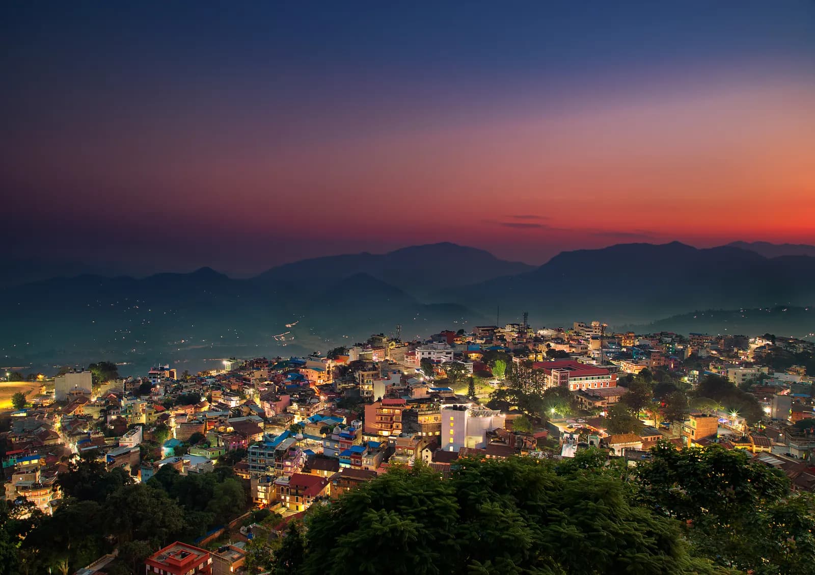
Tansen, Srinagar Hill and Ranighat
A two-day walk from the Magar hill town of Tansen: the lanes and the Srinagar Hill view tower on day one, and a 13 km descent to the Rani Mahal palace at Ranighat on day two, with no permit.
- दिन2
- अधिकतम उचाइ१,४९० मि
- दूरी१७.४ कि.मि.
- उकालो२९८ मि
- कठिनाइसजिलो
- उत्तम महिनाOct–Nov, Mar–Apr
यो यात्रा तालिकासहित ट्रिपको योजना बनाउनुहोस्Tansen, Srinagar Hill and Ranighat का लागि साथी खोज्नुहोस्हप्ताअनुसार प्रस्थान हेर्नुहोस्
फोटो: Mithunkunwar9 · CC BY-SA 4.0
अंग्रेजीमा देखाइएको — अझै अनुवाद भएको छैन।
यो यात्रा तालिका मस्यौदा हो र अझै प्रमाणित भएको छैन। चरणहरू सधैं आफ्नो गाइडसँग पुष्टि गर्नुहोस्।
Written by FindTrekkingPartner teamFindTrekkingPartner team द्वारा समीक्षितहामी कसरी समीक्षा गर्छौंFindTrekkingPartner
Tansen, Srinagar Hill and Ranighat नेपालको Palpa (Tansen) क्षेत्रमा पर्ने 2 दिनको ट्रेक हो, जुन १,४९० मिटरसम्म उक्लिन्छ। विदेशी ट्रेकरहरूले आफ्नो मिति, बजेट र गतिसहित ट्रिप पोस्ट गरेर FindTrekkingPartner मा यसका लागि साथी खोज्न सक्छन्। दुवै ट्रेकर सहमत नभएसम्म म्याचहरू निजी रहन्छन्, र सेवा निःशुल्क छ। मध्यम स्तरको दरमा, चार जना ट्रेकरले बाँड्दा 2 दिनको लागि इजाजतपत्रप्राप्त गाइडको खर्च प्रति व्यक्ति लगभग USD १९ पर्छ, जबकि एक्लै जाँदा USD ७५ पर्छ। उत्तम मौसमहरू Oct–Nov, Mar–Apr हुन्। यस्ता खुला रुटहरूमा इजाजतपत्रप्राप्त गाइड अनिवार्य रूपमा लागू गरिएको छैन (१९ अक्टोबर २०२६ मा जाँचिएको): खुम्बु नगरपालिकाले नेपाल पर्यटन बोर्डको अप्रिल २०२३ को नियमबाट बाहिर रहने निर्णय गरेको छ र दिनभरका हाइकमा गाइड चाहिँदैन, तर पनि गाइड राख्न कडा सल्लाह दिइन्छ, त्यसैले आफ्नो एजेन्सीसँग पुष्टि गर्नुहोस्। पछिल्लो पटक पुष्टि गरिएको: २०२६ अक्टोबर १९। स्रोतहरू: नेपाल पर्यटन बोर्ड, DNPWC, अध्यागमन विभाग।
स्रोतहरू:Department of Immigration, NepalNepal Tourism BoardDepartment of National Parks and Wildlife Conservation
Tansen, Srinagar Hill and Ranighat का लागि साथी खोज्नुहोस्
- Tansen, Srinagar Hill and Ranighat का लागि साथी खोज्नुहोस्अहिलेसम्म कुनै खुला ट्रिप छैन
परिचय
Tansen बाट सुरु२ दिन · अधिकतम १,४९० मि
उत्तम मौसम: Oct–Nov, Mar–Apr
Tansen, Srinagar Hill and Ranighat is a two-day walking plan from the Magar hill town of Tansen in Palpa: a town and hill day to Sitalpati and the Srinagar view tower, and a long descent to Rani Mahal, the Rana palace at Ranighat on the Kali Gandaki. On our map the first day is 4.4 km with about 160 m of climbing and the second is 13.0 km with about 1,000 m of descent, mostly on the Rani Mahal road. Sources give 30 to 60 minutes from town to Srinagar Hill and 2 to 3 hours down to Ranighat, with a return climb of about 4 hours or a car, so the second day is a big one-way day. No permit or flight is needed, and October to November and March to April are best.
What the walk is like
Day one is gentle: the old lanes of Tansen, the white octagonal Sitalpati pavilion, the Palpa Durbar and the climb to Srinagar Hill for a view from Dhaulagiri to Langtang. Day two goes down the valley of the Barandi Khola, through terraces, forest and small farms, to Ranighat, where the restored Rani Mahal stands on a bluff above the river. Most walkers go down on foot and come back by car, since the climb back is steep and takes about 4 hours.
Day by day
Day one is 4.4 km, 2 to 3 hours including time in the town. Day two is 13.0 km down, 3 to 4 hours, and a car or the 4 hour climb back to Tansen. If you prefer a shorter day, drive to Batase Danda on the ridge and walk from there, as a 2008 trip report did, which gives about 3 hours down to Ranighat.
Getting there and away
Tansen lies between Pokhara (122 km) and Lumbini (85 km) on the highway between Butwal and Pokhara, with direct buses from Kathmandu, Pokhara and Bhairahawa; Bhairahawa is about two hours away.
Permits, guides and costs
No trekking permit or TIMS card is needed, and Palpa lies outside any national park, conservation area or restricted area, so no guide is required; one is optional. Costs are the two nights, the transfers and the car back from Ranighat; see the cost section for ranges.
Season and safety
Clear air in October to November makes the best views, and March to April is warm. The pebble trail and stone steps are slippery in fog and rain, and the valley is hot in spring. See our guide rule page for the rule in full.
मुख्य आकर्षण
- Old Tansen lanes with the octagonal Sitalpati pavilion and the Palpa Durbar
- Srinagar Hill view tower, 30 to 60 minutes from town, over Dhaulagiri, Annapurna and Langtang
- A long descent to Rani Mahal, the restored Rana palace on the Kali Gandaki
- Dhaka cloth and brass pots from the shops of the old town
- No permit and no flight
मार्ग नक्सा
मार्गको डेटा OpenStreetMap बाट लिइएको हो, हाम्रो टोलीले अझै जाँचेको छैन। योजना बनाउन प्रयोग गर्नुहोस्, नेभिगेसनका लागि होइन।
दिनदिनको विवरण
Leave early and head down towards the Kali Gandaki. Sources give 2 to 3 hours for the descent, and our map shows 13.0 km with about 1,000 m of descent, mostly by the Rani Mahal road through terraced fields and forest, so we allow 3 to 4 hours. Rani Mahal, built in 1893 by General Khadga Shamsher for his wife, stands on a wooded bluff above the river and has been a museum since its restoration in 2017. The climb back to Tansen takes about 4 hours and is steep, so most visitors arrange a car for the return, then rest in town.
कति खर्च लाग्छ
प्रति व्यक्ति अनुमानित सबै-समेतको खर्च: उचाइअनुसार लज र खाना, यातायात, अनुमतिपत्र, र गाइड तथा पोर्टर। जति धेरै ट्रेकरले गाइड र पोर्टर बाँड्छन्, प्रत्येकले त्यति कम तिर्छन्। २०२६ अक्टोबर सम्मको अनुसार।
| शैली | १ ट्रेकर | २ ट्रेकर बाँडेर | ४ ट्रेकर बाँडेर |
|---|---|---|---|
| किफायती | US$ ३०–US$ ६०* | US$ ३०–US$ ६०* | US$ ३०–US$ ६०* |
| मध्यम | US$ १३०–US$ २२०* | US$ ८०–US$ १५०* | US$ ७०–US$ १२०* |
| आरामदायी | US$ १५०–US$ २४०* | US$ १२०–US$ १९०* | US$ १००–US$ १७०* |
गाइड बाँडेर पैसा बचाउनुहोस्
मध्यम स्तरमा, एक्लो ट्रेकरले करिब US$ १३०–US$ २२० तिर्छ; एउटा गाइड र दुई पोर्टर बाँड्ने चार ट्रेकरले प्रत्येकले करिब US$ ७०–US$ १२० तिर्छन् (दायराको माथिल्लो छेउमा 44% कम)।
२ ट्रेकरले बाँड्दाको विवरण
| विवरण | किफायती | मध्यम | आरामदायी |
|---|---|---|---|
| लज र खाना | US$ ३०–US$ ६० | US$ ४०–US$ ८० | US$ ५०–US$ १०० |
| गाइड | — | US$ २०–US$ ५० | US$ २०–US$ ५० |
| पोर्टर | — | US$ १०–US$ ३० | US$ ३०–US$ ६० |
बजेटमा सार्वजनिक यातायात र पोर्टरबिना; मध्यम स्तरमा दुई ट्रेकरबीच एक पोर्टर र निजी सवारी साधन बाँडिन्छ; आरामदायीमा प्रत्येक ट्रेकरलाई एक पोर्टर। गाइड अनिवार्य भएको ठाउँमा वा मध्यम स्तर अथवा आरामदायी शैलीमा समावेश गरिएको हुन्छ।
रातको लज र खाना (कोठा र दाल भात)
२ रात Below 2,500 m: कोठा US$ २–US$ ९, दाल भात US$ ४–US$ ७
समावेश छैन
यिनको प्रकाशित मूल्य भेटिएन: Pokhara to Tansen by bus or car; Ranighat back to Tansen by car। * चिन्ह लागेका जम्मा रकममा यी छुटेका छन्; आफ्नो एजेन्सीसँग सोध्नुहोस्। A homestay-based walk with no permit: the costs are the nights, meals and the car back from Ranighat. A guide is optional.
खर्चका स्रोतहरू
- PriceNepal: Nepal Travel Cost Guide 2026 (2026-05-14)
- Third Rock Adventures: Nepal trek budget planner (2026-05-09)
- Himalayan Partner: Guide and porter price in Nepal 2026 (2026-02-10)
- Shikhar Adventure: Annapurna Circuit trek cost (2026-02-03)
- Nepal Tourism Board: Trekking Permit (2026-10-18)
अपरेटर गाइडबाट लिइएका अनुमान हुन्, कोटेसन होइनन्। टिप, बीमा, सामान र काठमाडौंका होटल समावेश छैनन्; USD प्लेटफर्मको विनिमय दरमा।
फोटोहरू
प्रायः सोधिने प्रश्नहरू
Sources give 2 to 3 hours down, and our map shows 13.0 km, so we allow 3 to 4 hours. The climb back is about 4 hours, or arrange a car.
Possible but long. Srinagar Hill is 30 to 60 minutes from town and the Ranighat descent 3 to 4 hours, so most walkers split the two days.
Yes. The palace was restored in 2017 and has a museum inside. Ask in Tansen about any ticket and the opening time on the day.
October to November for clear views and March to April for warm days; the monsoon brings cloud and mud.
No. Palpa is not a restricted area, and the walks avoid national parks and conservation areas. A guide is optional.
स्रोतहरू
बाटोभरि
मार्गको हरेक दिन बास, चिकित्सा सहायता, पानी र हेर्नलायक ठाउँहरू।
1. Tansen
- Sangam medical hall · चिकित्सा · १,२८१ मि
- Ayush pharmacy · चिकित्सा · १,२७३ मि
- The Bajra · बास · १,२७७ मि
- Laxmi Homestay · बास · १,३३१ मि
- Horizon Homestay · बास · १,३५० मि
- Annapurna garden · बास · १,३२९ मि
- View Tower · दृश्यावलोकन स्थल · १,४९२ मि
- Shreenagar View Tower · दृश्यावलोकन स्थल · १,४३९ मि
Show all 13 places
- The Bajra · बास · १,२७७ मि
- Lumbini Medical College · विमानस्थल र यातायात · ८७३ मि
- Hotel Tansen · बास · १,२६२ मि
- Sangam medical hall · चिकित्सा · १,२८१ मि
- Ayush pharmacy · चिकित्सा · १,२७३ मि
- Rock Regency Guest House · बास · १,२६९ मि
- Hotel Crown · बास · १,३०५ मि
- Laxmi Homestay · बास · १,३३१ मि
- Horizon Homestay · बास · १,३५० मि
- Annapurna garden · बास · १,३२९ मि
- United Mission Tansen Hospital · चिकित्सा · १,३२० मि
- View Tower · दृश्यावलोकन स्थल · १,४९२ मि
- Shreenagar View Tower · दृश्यावलोकन स्थल · १,४३९ मि
2. Tansen → Ranighat
- LMC Town Clinic · चिकित्सा · १,२७७ मि
- Indreni Restaurant and Lodge · बास · १,२७५ मि
- Ashoka Guest House $ · बास · १,२७६ मि
- Palpa District Hospital · चिकित्सा · १,३०० मि
- The White Lake · बास · १,३१२ मि
- Batasedaada · दृश्यावलोकन स्थल · १,३९३ मि
- Rice fields Valley · दृश्यावलोकन स्थल · १,०१० मि
- Dew Camping Resort · बास · ६९२ मि
Show all 16 places
- Indreni Restaurant and Lodge · बास · १,२७५ मि
- Ashoka Guest House $ · बास · १,२७६ मि
- Upakar Medical Hall · चिकित्सा · १,२७८ मि
- LMC Town Clinic · चिकित्सा · १,२७७ मि
- The White Lake · बास · १,३१२ मि
- Palpa District Hospital · चिकित्सा · १,३०० मि
- Hotel Gauri Shankar · बास · १,२९४ मि
- Bhattarai medical hall · चिकित्सा · १,३२२ मि
- City View Homestay · बास · १,३३० मि
- Amatya Homestay · बास · १,३३१ मि
- Sunrise View Homestay · बास · १,३३२ मि
- Hotel Srinagar · बास · १,४२० मि
- Batasedaada · दृश्यावलोकन स्थल · १,३९३ मि
- Rice fields Valley · दृश्यावलोकन स्थल · १,०१० मि
- Ranimahal Fishing Resort · बास · ८७७ मि
- Dew Camping Resort · बास · ६९२ मि
अन्तिम पटक २०२६ अक्टोबर १९ मा प्रमाणितपुरानो जानकारी रिपोर्ट गर्नुहोस्