

Drive from Kathmandu to Dhunche, at 1,960 m, a journey of six to seven hours along the Trishuli river and up through terraced hills and forest. Dhunche is the headquarters of Rasuwa district and the entrance to Langtang National Park, where permits are checked. The town has lodges, shops and views of Langtang Lirung on a clear day. Check your gear and permits, drink plenty of water and rest. Tomorrow is a steep climb, and the weather in the hills can change quickly. Ask the lodge about trail conditions.
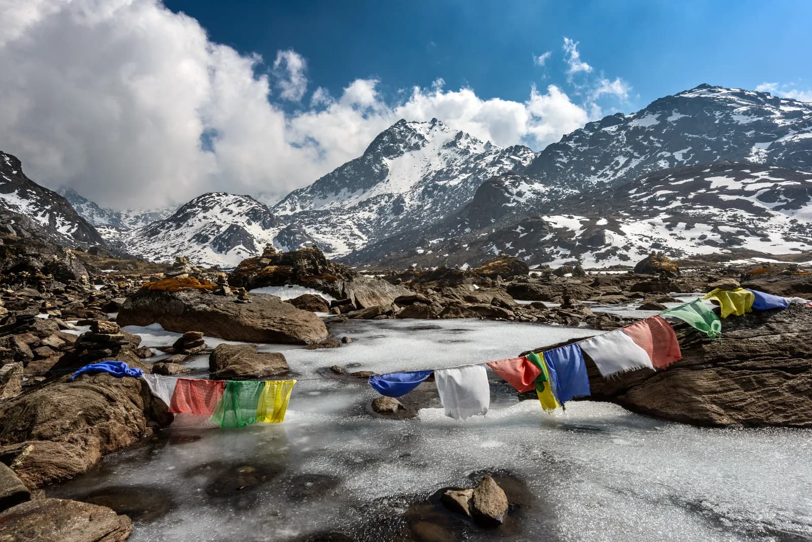
Gosaikunda Lake Trek
A short, steep climb to the sacred alpine lakes of Gosaikunda, returning via Thulo Syabru.
- दिन6
- अधिकतम उचाइ४,३८० मि
- दूरी३२.२ कि.मि.
- उकालो२,५३६ मि
- कठिनाइमध्यम
- उत्तम महिनाMar–May, Oct–Nov
- अनुमतिपत्र2
यो यात्रा तालिकासहित ट्रिपको योजना बनाउनुहोस्Gosaikunda Lake Trek का लागि साथी खोज्नुहोस्हप्ताअनुसार प्रस्थान हेर्नुहोस्
फोटो: Sergey Pesterev · CC BY-SA 4.0
चेतावनीGosaikunda: road access to Dhunche is recovering and the Syabrubesi finish is affected
This route starts with a drive to Dhunche and ends by walking from Thulo Syabru to Syabrubesi, then driving to Kathmandu. On 26 August 2026 a large rock-and-ice collapse from the north face of Langtang Lirung sent a debris flow down the Lhende Khola into the Bhote Koshi and Trishuli rivers, hitting Rasuwagadhi, Timure, Syabrubesi and Betrawati (ICIMOD). Many bridges and long stretches of the Pasang Lhamu Highway were damaged, and a large number of people died or are missing; reported figures differ by source.
The Trishuli Bazaar-Betrawati-Dhunche road was reported still closed for repair as of 21 September. A light-vehicle track has reopened, and agencies projected the remaining gaps passable no earlier than mid-October; that is a projection, not an official date. Syabrubesi, the usual Langtang road-head, is reported destroyed or closed as a trekking gateway, with the bridge to it swept away; restoration depends on the Betrawati highway reopening.
Plan the finish with your agency: a reported alternative is to descend from Thulo Syabru towards Dhunche instead of Syabrubesi. ICIMOD warns that loose debris in the valley can be remobilised by monsoon rain.
We found no official reopening notice. Check current road and trail conditions with Langtang National Park and your trekking agency before booking, and do not rely on this summary alone.
स्थिति 2026-10-19 मा जाँचिएको।
स्रोतहरू: ICIMOD: Kyirong-Rasuwa flood, 26 August 2026 · Nepal Pyramids: Langtang Valley trek update after the 2026 flooding · TravelNepal: Nepal floods 2026 travel safety update · Republica: locals reopen flood-damaged Langtang trekking route (16 Oct)
अंग्रेजीमा देखाइएको — अझै अनुवाद भएको छैन।
यो यात्रा तालिका मस्यौदा हो र अझै प्रमाणित भएको छैन। चरणहरू सधैं आफ्नो गाइडसँग पुष्टि गर्नुहोस्।
Written by FindTrekkingPartner teamFindTrekkingPartner team द्वारा समीक्षितहामी कसरी समीक्षा गर्छौंFindTrekkingPartner
Gosaikunda Lake Trek नेपालको Langtang क्षेत्रमा पर्ने 6 दिनको ट्रेक हो, जुन ४,३८० मिटरसम्म उक्लिन्छ। विदेशी ट्रेकरहरूले आफ्नो मिति, बजेट र गतिसहित ट्रिप पोस्ट गरेर FindTrekkingPartner मा यसका लागि साथी खोज्न सक्छन्। दुवै ट्रेकर सहमत नभएसम्म म्याचहरू निजी रहन्छन्, र सेवा निःशुल्क छ। मध्यम स्तरको दरमा, चार जना ट्रेकरले बाँड्दा 6 दिनको लागि इजाजतपत्रप्राप्त गाइडको खर्च प्रति व्यक्ति लगभग USD ३८ पर्छ, जबकि एक्लै जाँदा USD १५० पर्छ। उत्तम मौसमहरू Mar–May, Oct–Nov हुन्। यहाँ व्यवहारमा इजाजतपत्रप्राप्त गाइड आवश्यक छ: २०२६ का सञ्चालकहरूका अनुसार नेपाल पर्यटन बोर्डको अप्रिल २०२३ को नियम राष्ट्रिय निकुञ्ज र संरक्षण क्षेत्रका चेकपोइन्टहरूमा लागू गरिन्छ, जसमा लाङटाङ सबैभन्दा कडा छ र अन्नपूर्णमा पनि जाँच हुन्छ (१९ अक्टोबर २०२६ मा जाँचिएको)। दर्ता भएको एजेन्सीमार्फत गाइड लिनुहोस् र उनीहरूसँग पुष्टि गर्नुहोस्। पछिल्लो पटक पुष्टि गरिएको: २०२६ अक्टोबर २१। स्रोतहरू: नेपाल पर्यटन बोर्ड, DNPWC, अध्यागमन विभाग।
स्रोतहरू:Department of Immigration, NepalNepal Tourism BoardDepartment of National Parks and Wildlife Conservation
Gosaikunda Lake Trek का लागि साथी खोज्नुहोस्
- Gosaikunda Lake Trek का लागि साथी खोज्नुहोस्२ खुला ट्रिपहरू
- Langtang Valley Trek का लागि साथी खोज्नुहोस्अहिलेसम्म कुनै खुला ट्रिप छैन
- Tamang Heritage Trail का लागि साथी खोज्नुहोस्अहिलेसम्म कुनै खुला ट्रिप छैन
- Helambu Trek का लागि साथी खोज्नुहोस्अहिलेसम्म कुनै खुला ट्रिप छैन
परिचय
Kathmandu बाट सुरु६ दिन · अधिकतम ४,३८० मि
उत्तम मौसम: Mar–May, Oct–Nov · अनुमतिपत्र: Langtang National Park entry permit, TIMS card where required
The Gosaikunda trek climbs from Dhunche to a group of sacred alpine lakes at about 4,380 m in Langtang National Park, then returns through Thulo Syabru to Syabrubesi. Gosaikunda is a Hindu and Buddhist pilgrimage site, said to have been created when Shiva struck the ground with his trident to quench his thirst after swallowing poison, and the area has 108 lakes in the vicinity, according to local tradition. This six-day plan drives from Kathmandu to Dhunche, climbs to Chandanbari (Sing Gompa), ascends through Laurebina to the lakes, descends to Thulo Syabru in a long day, and ends at Syabrubesi with the drive back. It is short but steep, and the altitude gain is fast, so it needs care. It suits fit walkers who want a short trek to a pilgrimage lake and who will respect the fast altitude gain with a slow pace and plenty of water.
What the trek is like
The route climbs steadily through oak and rhododendron forest to Sing Gompa, then through juniper and rhododendron to Laurebina Yak, where the forest ends. Above this point the trail follows a rocky ridge with exposed sections. The lakes sit in a cirque, and the main lake, Gosaikunda, is surrounded by smaller lakes including Saraswati Kunda, Bhairav Kunda and Surya Kunda. The descent to Thulo Syabru is long and steep, through forest and terraces, and ends with a walk down to Syabrubesi.
Highlights
- Rhododendron forest above Dhunche
- Sing Gompa, a small monastery with a cheese factory
- Laurebina ridge and the view of Himalayan peaks
- Gosaikunda lake and its neighbours, sacred to Hindus and Buddhists
- Thulo Syabru, a Tamang village with views of Langtang Lirung
Permits and rules
You need a Langtang National Park entry permit and a TIMS card where required. The Nepal Tourism Board April 2023 rule requires foreign trekkers to use a licensed guide in national parks and conservation areas, and 2026 operator reports say checkpoints enforce it in Annapurna (ACAP), Langtang (the strictest) and most other parks, but not in Khumbu, where the municipality opted out (checked 19 October 2026). See the guide rule by region. A guide is strongly recommended for this trek because of the exposed ridge and quick altitude gain. Check current fees with the issuing offices.
Best season
October and November are clearest, and April and May are good. The lakes freeze in winter and the trail is under snow; the monsoon brings rain and cloud, but the lakes host a festival at Janai Purnima in August, when thousands of pilgrims walk up.
Altitude
The route climbs from 1,960 m at Dhunche to 4,380 m at Gosaikunda in two days, which is fast. Altitude sickness is common here, so go slowly, drink plenty of water, and consider adding a night at Sing Gompa or Laurebina. If you have a headache or nausea, do not go higher. The descent to Thulo Syabru is long and steep.
Getting there and away
The drive from Kathmandu to Dhunche takes about 6 to 7 hours. From Syabrubesi, the drive back takes 7 to 8 hours. Landslides sometimes close the road in the monsoon.
Lodges, food and costs
Lodges at Chandanbari, Laurebina Yak and Gosaikunda are simple. Nights are very cold, and many lodges have no heating in bedrooms. Carry cash, because there are no machines on the trail.
Packing list
Waterproof boots, warm layers, a down jacket, hat and gloves, a sleeping bag rated to about -10 C, trekking poles, a headlamp, water purification and a first-aid kit.
Who this trek suits and how to prepare
The trek suits fit trekkers who want a short route and are comfortable with steep climbs. Prepare with stair climbing and hill walks. The altitude gain is fast, so previous experience at 3,000 to 4,000 m helps. Pack warm clothes, because the lakes are cold even in autumn.
The plan at a glance
Day 1 drives to Dhunche (1,960 m). Day 2 climbs to Sing Gompa (Chandanbari, 3,330 m). Day 3 climbs through Laurebina to Gosaikunda (4,380 m). Day 4 descends to Thulo Syabru (2,210 m), day 5 walks to Syabrubesi, and day 6 drives back to Kathmandu.
Extensions
From Gosaikunda you can continue over Laurebina La, at about 4,650 m, to Helambu, a trek of three to four more days that ends near Kathmandu. Others combine Gosaikunda with the Langtang Valley, returning to Syabrubesi and walking up the valley. Discuss the options with your guide and agency.
Practical tips from the trail
- Go slowly on the climb to Laurebina: it is the steepest section.
- Check the weather before leaving Sing Gompa, because the ridge is exposed.
- Carry water, because springs are few above the treeline.
- Take warm gloves and a hat for the lakeside.
- If you visit during Janai Purnima in August, expect crowds and book ahead.
Responsible trekking
Gosaikunda is a sacred site, so do not swim, wash or leave rubbish in the lakes, and respect the temple and pilgrims. Carry out your waste and buy from local lodges.
Food and lodging
Lodges at Dhunche, Sing Gompa, Laurebina Yak and Gosaikunda serve dal bhat, noodles, soup, eggs and tea. At Sing Gompa, cheese from the local cheese factory is a treat. Rooms are cold, with blankets and sometimes no heating, so bring a warm sleeping bag. Charging is expensive and slow, and hot showers are not available above Dhunche. Meals cost more at altitude because supplies are carried up by porters.
Photography tips
Early morning gives the best light on the lakes, when the water is still and the surrounding peaks reflect in it. Bring a polarising filter to reduce glare, and a wide-angle lens for the cirque. At Laurebina, the ridge gives a long view of the Himalayan range on clear days. Keep your camera and spare batteries warm, because they drain quickly in the cold.
मुख्य आकर्षण
- Sing Gompa and Chandanbari
- Laurebina ridge views
- Gosaikunda sacred lake at 4,380 m
- Saraswati Kunda and Bhairav Kunda
- Thulo Syabru
मार्ग नक्सा
मार्गको डेटा OpenStreetMap बाट लिइएको हो, हाम्रो टोलीले अझै जाँचेको छैन। योजना बनाउन प्रयोग गर्नुहोस्, नेभिगेसनका लागि होइन।
दिनदिनको विवरण
तपाईं अघिल्लो रातभन्दा १,३७० मि माथि सुत्नुहुन्छ, जुन सामान्य ५०० मिटरको मार्गदर्शनभन्दा बढी हो। बिस्तारै हिँड्नुहोस्, प्रशस्त पानी पिउनुहोस् र टाउको दुखाइ वा वाकवाकी भए ध्यान दिनुहोस्।
Climb steeply through oak and rhododendron forest from Dhunche to Bharku and on to Sing Gompa, also called Chandanbari, at about 3,330 m. The trail is a series of switchbacks through the trees, with views of Langtang Lirung when the clouds lift. Sing Gompa has a small monastery and a cheese factory, and several lodges. It is a hard five to six hours' walk, and the altitude gain is considerable. Drink water and watch for headaches. The evening is cold, and the lodge dining room is the warmest place.
तपाईं अघिल्लो रातभन्दा १,०५० मि माथि सुत्नुहुन्छ, जुन सामान्य ५०० मिटरको मार्गदर्शनभन्दा बढी हो। बिस्तारै हिँड्नुहोस्, प्रशस्त पानी पिउनुहोस् र टाउको दुखाइ वा वाकवाकी भए ध्यान दिनुहोस्।
Climb through juniper and rhododendron forest to Laurebina Yak, where the trees end and the views open up. Continue along a rocky ridge, taking care in the exposed sections, to Gosaikunda, at about 4,380 m, with a series of lakes in a rocky cirque. The main lake, Gosaikunda, is a sacred site for Hindus and Buddhists, and Bhairav Kunda and Saraswati Kunda lie nearby. It is a big altitude gain, and the day takes five to six hours. Go slowly, drink water and do not continue if you have symptoms of altitude sickness.
Spend the morning at the lakes, enjoying the views of the high peaks, then start the long descent. The path climbs briefly over the Laurebina La side, then drops steeply through rhododendron and bamboo forest to Phedi and Thulo Syabru, at 2,210 m, a Tamang village with terraced fields and a view of Langtang Lirung. It is a long day of seven to eight hours, and the descent is hard on the knees, so use poles. Thulo Syabru has a number of lodges, and you can feel the warmth of the lower altitude.
Walk down from Thulo Syabru through terraced fields and forest to the Bhote Koshi valley, crossing a suspension bridge and following the road to Syabrubesi, at 1,460 m, a walk of about four hours. The path is mostly downhill, with views of the valley and Tibetan peaks. Syabrubesi is a lively village with lodges and shops. Have a hot shower, a good meal and a rest. Pay your guide and porters, and have a farewell dinner. If the road is affected by landslides, ask about conditions for tomorrow.
Drive from Syabrubesi to Kathmandu via Dhunche and Trishuli, a journey of seven to eight hours. Start early to avoid delays caused by landslides or roadworks. The road follows the Trishuli river and drops through terraces and forest. Arrive in the capital in the late afternoon. In Kathmandu, shower, repack and reflect on the trek. If you have time, visit Boudhanath or Pashupatinath. Do not schedule an international flight for the same evening, because the road can be slow or blocked.
अनुकूलन
रातैपिच्छे सुत्ने उचाइ। रातो पट्टीहरू अघिल्लो रातभन्दा ५०० मिटरभन्दा बढी चढेका हुन्; आराम दिन चिन्ह लगाइएको छ।
- सुत्ने उचाइ
- ५०० मिटरभन्दा बढी चढाइ
- आराम दिन
कति खर्च लाग्छ
प्रति व्यक्ति अनुमानित सबै-समेतको खर्च: उचाइअनुसार लज र खाना, यातायात, अनुमतिपत्र, र गाइड तथा पोर्टर। जति धेरै ट्रेकरले गाइड र पोर्टर बाँड्छन्, प्रत्येकले त्यति कम तिर्छन्। २०२६ अक्टोबर सम्मको अनुसार।
| शैली | १ ट्रेकर | २ ट्रेकर बाँडेर | ४ ट्रेकर बाँडेर |
|---|---|---|---|
| किफायती | US$ २७०–US$ ४२० | US$ २१०–US$ ३३० | US$ १८०–US$ २८० |
| मध्यम | US$ ५७०–US$ ९७० | US$ ३७०–US$ ६१० | US$ २८०–US$ ४५० |
| आरामदायी | US$ ६२०–US$ १,०५० | US$ ४४०–US$ ७२० | US$ ३६०–US$ ५६० |
गाइड बाँडेर पैसा बचाउनुहोस्
मध्यम स्तरमा, एक्लो ट्रेकरले करिब US$ ५७०–US$ ९७० तिर्छ; एउटा गाइड र दुई पोर्टर बाँड्ने चार ट्रेकरले प्रत्येकले करिब US$ २८०–US$ ४५० तिर्छन् (दायराको माथिल्लो छेउमा 54% कम)।
२ ट्रेकरले बाँड्दाको विवरण
| विवरण | किफायती | मध्यम | आरामदायी |
|---|---|---|---|
| लज र खाना | US$ १००–US$ १६० | US$ १३०–US$ २१० | US$ १७०–US$ २७० |
| यातायात | US$ १०–US$ ५० | US$ ११०–US$ २३० | US$ ११०–US$ २३० |
| अनुमतिपत्र | US$ ३०–US$ ४० | US$ ३०–US$ ४० | US$ ३०–US$ ४० |
| गाइड | US$ ६०–US$ ९० | US$ ६०–US$ ९० | US$ ६०–US$ ९० |
| पोर्टर | — | US$ ३०–US$ ६० | US$ ६०–US$ ११० |
बजेटमा सार्वजनिक यातायात र पोर्टरबिना; मध्यम स्तरमा दुई ट्रेकरबीच एक पोर्टर र निजी सवारी साधन बाँडिन्छ; आरामदायीमा प्रत्येक ट्रेकरलाई एक पोर्टर। गाइड अनिवार्य भएको ठाउँमा वा मध्यम स्तर अथवा आरामदायी शैलीमा समावेश गरिएको हुन्छ।
रातको लज र खाना (कोठा र दाल भात)
३ रात Below 2,500 m: कोठा US$ २–US$ ९, दाल भात US$ ४–US$ ७ · १ रात 2,500 to 3,800 m: कोठा US$ ३–US$ ७, दाल भात US$ ४–US$ ७ · १ रात Above 3,800 m: कोठा US$ ७–US$ १९, दाल भात US$ ८–US$ १३
अनुमतिपत्र शुल्क (आधिकारिक स्रोत)
खर्चका स्रोतहरू
- PriceNepal: Nepal Travel Cost Guide 2026 (2026-05-14)
- Third Rock Adventures: Nepal trek budget planner (2026-05-09)
- Himalayan Partner: Guide and porter price in Nepal 2026 (2026-02-10)
- Shikhar Adventure: Annapurna Circuit trek cost (2026-02-03)
- Third Rock Adventures: Kathmandu to Syabrubesi (2026-10-18)
अपरेटर गाइडबाट लिइएका अनुमान हुन्, कोटेसन होइनन्। टिप, बीमा, सामान र काठमाडौंका होटल समावेश छैनन्; USD प्लेटफर्मको विनिमय दरमा।
फोटोहरू
प्रायः सोधिने प्रश्नहरू
Moderate but steep. The altitude gain is fast, from 1,960 m to 4,380 m in two days, and the descent to Thulo Syabru is long.
Six days on this plan, from Kathmandu to Kathmandu.
About 4,380 m.
Hindu tradition says Shiva created the lake by striking the ground with his trident. Pilgrims visit, especially at the Janai Purnima festival in August.
October to November, and April and May.
A licensed guide is required in practice: the Nepal Tourism Board April 2023 rule is enforced at checkpoints in Annapurna and Langtang and most parks (2026 operator reports, checked 19 October 2026). A guide is strongly recommended for the exposed ridge and quick altitude gain.
स्रोतहरू
बाटोभरि
मार्गको हरेक दिन बास, चिकित्सा सहायता, पानी र हेर्नलायक ठाउँहरू।
1. Kathmandu → Dhunche
- त्रिभुवन अन्तर्राष्ट्रिय विमानस्थल · विमानस्थल र यातायात · १,३४० मि
2. Dhunche → Chandanbari
- Dunche Guest House · बास · २,०२७ मि
- Hotel Langtang View · बास · २,०३३ मि
- Hotel Ki-yang · बास · २,०३२ मि
- Rasuwa District Hospital · चिकित्सा · २,१०९ मि
- Dhunche Pharmacy · चिकित्सा · २,०२९ मि
- Tap · उपयोगी · २,०१५ मि
- Drinking Water · उपयोगी · २,५०५ मि
- Deurali · बास · २,६६४ मि
Show all 14 places
- Dunche Guest House · बास · २,०२७ मि
- Hotel Langtang View · बास · २,०३३ मि
- Hotel Ki-yang · बास · २,०३२ मि
- Sunrise Hotel · बास · २,०३२ मि
- Dhunche national Guest House · बास · २,०३१ मि
- Rasuwa District Hospital · चिकित्सा · २,१०९ मि
- Dhunche Pharmacy · चिकित्सा · २,०२९ मि
- Tap · उपयोगी · २,०१५ मि
- Mama Vanja Hotel & Lodge · बास · २,००४ मि
- Ghatta Khola · बास · १,९७७ मि
- Mini Gosaikunda hotel and lodge · बास · १,९८१ मि
- New Village Hotel and Lodge · बास · २,३११ मि
- Drinking Water · उपयोगी · २,५०५ मि
- Deurali · बास · २,६६४ मि
3. Chandanbari → Gosaikunda
- Hotel Tashi Delek · बास · ३,३०० मि
- Hotel Red Panda · बास · ३,३०० मि
- The Hotel Yak & Nak · बास · ३,३०९ मि
- Viewtower · दृश्यावलोकन स्थल · ३,३७५ मि
- Pine forest viewpoint · दृश्यावलोकन स्थल · ३,६१८ मि
- Hotel Mount Rest View · बास · ३,९३३ मि
Show all 9 places
- Hotel Tashi Delek · बास · ३,३०० मि
- Hotel Red Panda · बास · ३,३०० मि
- The Hotel Yak & Nak · बास · ३,३०९ मि
- Sunset Viewpoint Cottage · बास · ३,३२१ मि
- Viewtower · दृश्यावलोकन स्थल · ३,३७५ मि
- Pine forest viewpoint · दृश्यावलोकन स्थल · ३,६१८ मि
- Langtang Lirung View · बास · ३,६१७ मि
- Hotel Mount Rest View · बास · ३,९३३ मि
- Viewpoint · दृश्यावलोकन स्थल · ४,२४१ मि
4. Gosaikunda → Thulo Syabru
- View of Tibetan peak north of Syabrubensi · दृश्यावलोकन स्थल · २,३८१ मि
- Nepal view hotel & lodge · बास · २,२४१ मि
- Evening view · बास · २,२४० मि
- Ganesh Himal · बास · २,२३८ मि
- Ganesh Himal Hotel & Restaurant · बास · २,२३९ मि
Show all 17 places
- Mungkank kharka village · बास · २,९८३ मि
- Himalyan Guest House · बास · २,९८६ मि
- Laligurash · बास · २,९८२ मि
- Sherpa Cottage · बास · २,७३६ मि
- Karmu Guest House · बास · २,७११ मि
- View of Tibetan peak north of Syabrubensi · दृश्यावलोकन स्थल · २,३८१ मि
- Nepal view hotel & lodge · बास · २,२४१ मि
- Evening view · बास · २,२४० मि
- Ganesh Himal · बास · २,२३८ मि
- Ganesh Himal Hotel & Restaurant · बास · २,२३९ मि
- Peace Lodge and Restaurant · बास · २,२३८ मि
- Hotel Yak · बास · २,२३५ मि
- Blue Star lodge · बास · २,२२० मि
- Hotel Snowfall · बास · २,२२९ मि
- Mona Lisa · बास · २,२२९ मि
- Langtang view hotel & lodge · बास · २,२२७ मि
- Hotel Himalayan 3 Brothers Guest House · बास · २,२१५ मि
5. Thulo Syabru → Syabrubesi
- Namaste · बास · २,२०८ मि
- Stupa Guest House · बास · २,२०९ मि
- Hotel Buddha · बास · २,१९७ मि
- Paradise · बास · २,१५७ मि
Show all 6 places
- Namaste · बास · २,२०८ मि
- Stupa Guest House · बास · २,२०९ मि
- Hotel Buddha · बास · २,१९७ मि
- Paradise · बास · २,१५७ मि
- Tashi Dele · बास · २,११४ मि
- Tibetan friendly · बास · २,१६५ मि
6. Syabrubesi → Kathmandu
यो दिनका लागि अहिलेसम्म केही नक्सांकन भएको छैन।यो दिनका लागि अहिलेसम्म केही नक्सांकन भएको छैन।
अन्तिम पटक २०२६ अक्टोबर २१ मा प्रमाणितपुरानो जानकारी रिपोर्ट गर्नुहोस्