

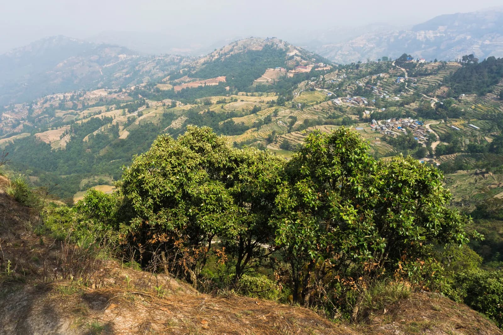
Drive from Kathmandu to Nagarkot, about 1.5 hours, ideally for sunrise, and have tea before you start. The trail leaves the ridge and descends through pine and rhododendron forest and terraced fields, passing Tamang and Newar villages. About two and a half hours on, you reach Telkot, the midway rest stop, where you can visit a small monastery. The way continues downhill with a few gentle ascents to Changu Narayan, a hilltop temple on the UNESCO World Heritage list, where lunch and sightseeing end the day. On our map it is 11.7 km with 150 m of climbing and 535 m of descent, mostly on village roads and tracks. A vehicle back to Kathmandu takes about an hour.
Nagarkot to Changu Narayan Day Hike
A one-day downhill walk from the ridge village of Nagarkot through Telkot and Newar and Tamang villages to Changu Narayan temple, 11.7 km on our map, mostly downhill.
- दिन1
- अधिकतम उचाइ२,१७५ मि
- दूरी११.७ कि.मि.
- उकालो१४९ मि
- कठिनाइसजिलो
- उत्तम महिनाMar–May, Oct–Nov
यो यात्रा तालिकासहित ट्रिपको योजना बनाउनुहोस्Nagarkot to Changu Narayan Day Hike का लागि साथी खोज्नुहोस्हप्ताअनुसार प्रस्थान हेर्नुहोस्
फोटो: Alexey Komarov · CC BY-SA 4.0
अंग्रेजीमा देखाइएको — अझै अनुवाद भएको छैन।
यो यात्रा तालिका मस्यौदा हो र अझै प्रमाणित भएको छैन। चरणहरू सधैं आफ्नो गाइडसँग पुष्टि गर्नुहोस्।
Written by FindTrekkingPartner teamFindTrekkingPartner team द्वारा समीक्षितहामी कसरी समीक्षा गर्छौंFindTrekkingPartner
Nagarkot to Changu Narayan Day Hike नेपालको Kathmandu Valley क्षेत्रमा पर्ने 1 दिनको ट्रेक हो, जुन २,१७५ मिटरसम्म उक्लिन्छ। विदेशी ट्रेकरहरूले आफ्नो मिति, बजेट र गतिसहित ट्रिप पोस्ट गरेर FindTrekkingPartner मा यसका लागि साथी खोज्न सक्छन्। दुवै ट्रेकर सहमत नभएसम्म म्याचहरू निजी रहन्छन्, र सेवा निःशुल्क छ। मध्यम स्तरको दरमा, चार जना ट्रेकरले बाँड्दा 1 दिनको लागि इजाजतपत्रप्राप्त गाइडको खर्च प्रति व्यक्ति लगभग USD ९ पर्छ, जबकि एक्लै जाँदा USD ३७ पर्छ। उत्तम मौसमहरू Oct–Nov, Mar–Apr हुन्। यस्ता खुला रुटहरूमा इजाजतपत्रप्राप्त गाइड अनिवार्य रूपमा लागू गरिएको छैन (१९ अक्टोबर २०२६ मा जाँचिएको): खुम्बु नगरपालिकाले नेपाल पर्यटन बोर्डको अप्रिल २०२३ को नियमबाट बाहिर रहने निर्णय गरेको छ र दिनभरका हाइकमा गाइड चाहिँदैन, तर पनि गाइड राख्न कडा सल्लाह दिइन्छ, त्यसैले आफ्नो एजेन्सीसँग पुष्टि गर्नुहोस्। पछिल्लो पटक पुष्टि गरिएको: २०२६ अक्टोबर १९। स्रोतहरू: नेपाल पर्यटन बोर्ड, DNPWC, अध्यागमन विभाग।
स्रोतहरू:Department of Immigration, NepalNepal Tourism BoardDepartment of National Parks and Wildlife Conservation
Nagarkot to Changu Narayan Day Hike का लागि साथी खोज्नुहोस्
- Nagarkot to Changu Narayan Day Hike का लागि साथी खोज्नुहोस्अहिलेसम्म कुनै खुला ट्रिप छैन
- Shivapuri Peak Day Hike का लागि साथी खोज्नुहोस्अहिलेसम्म कुनै खुला ट्रिप छैन
- Chisapani Nagarkot Trek का लागि साथी खोज्नुहोस्अहिलेसम्म कुनै खुला ट्रिप छैन
- Champadevi Day Hike का लागि साथी खोज्नुहोस्अहिलेसम्म कुनै खुला ट्रिप छैन
- Phulchowki Day Hike का लागि साथी खोज्नुहोस्अहिलेसम्म कुनै खुला ट्रिप छैन
- Namo Buddha Day Hike का लागि साथी खोज्नुहोस्अहिलेसम्म कुनै खुला ट्रिप छैन
परिचय
Nagarkot बाट सुरु१ दिन · अधिकतम २,१७५ मि
उत्तम मौसम: Mar–May, Oct–Nov
The Nagarkot to Changu Narayan hike is a one-day downhill walk from the ridge village of Nagarkot, about 2,150 m, through Telkot and a string of Tamang and Newar villages to the temple hill of Changu Narayan. On our map the walk is about 11.7 km with 150 m of climbing and 535 m of descent, on village roads, tracks and forest paths. Operators give about 14 km and four to five hours, with a rest stop at Telkot, so our shorter map line looks a little brisk. You drive about 1.5 hours from Kathmandu to Nagarkot, ideally in time for the sunrise view, and take about an hour back from Changu Narayan, or a short bus ride to Bhaktapur. The Nagarkot viewpoint and the Changu Narayan temple charge entrance fees. Carry water and lunch.
The plan follows two operator itineraries that agree on Nagarkot, Telkot and the temple, and on the timing of about four and a half hours with a break. Heights differ: sources give Nagarkot at 2,100 to 2,195 m, and Wikivoyage gives 2,163 m. The same descent is the last day of our Chisapani Nagarkot trek.
What the hike is like
The trail leaves Nagarkot's ridge and descends through pine and rhododendron forest and terraced fields, passing small Tamang and Newar villages. Telkot is the midway rest stop, with an optional monastery visit. The path is wide and easy as long as you wear hiking shoes, with a few gentle ascents. Changu Narayan sits on a hilltop. According to Wikipedia it was listed as a UNESCO World Heritage Site in 1979 and stands about 12 km east of Kathmandu, and a pillar there dates to 464 AD.
Permits and rules
None of our sources lists a park permit for this route. Two entrance fees apply: the Nagarkot viewpoint and the Changu Narayan temple, which operators include in their prices without giving amounts. Dress modestly at the temple and keep to the marked path.
Best season
October to November and March to May, according to operators, who also say it can be walked all year. Autumn and spring have the clearest mountain views; Nagarkot sunrise views are best before cloud builds.
Getting there and away
A taxi from Kathmandu to Nagarkot costs NPR 2,000 to 3,000 one way and takes 1.5 to 2 hours, according to Wikivoyage. Public buses via Bhaktapur cost under NPR 100 and take about two hours. From Changu Narayan a private vehicle takes about one hour to Kathmandu, or a short bus ride reaches Bhaktapur.
Difficulty and fitness
The route is easy: it descends 535 m over 11.7 km, on wide paths and quiet roads. Wear shoes with grip, carry two litres of water, and start by 9 am.
Budget notes
The main cost is the taxi to Nagarkot, NPR 2,000 to 3,000 one way, plus the two entrance fees and lunch. The return from Changu Narayan is shown as a line to check.
मुख्य आकर्षण
- Nagarkot at about 2,150 m, a classic Himalayan viewpoint
- Telkot, the midway rest stop, with an optional monastery visit
- Pine and rhododendron forest, terraced fields and Tamang and Newar villages
- Changu Narayan, a hilltop temple and UNESCO World Heritage Site
- Mostly downhill, so easy on the legs
मार्ग नक्सा
मार्गको डेटा OpenStreetMap बाट लिइएको हो, हाम्रो टोलीले अझै जाँचेको छैन। योजना बनाउन प्रयोग गर्नुहोस्, नेभिगेसनका लागि होइन।
दिनदिनको विवरण
कति खर्च लाग्छ
प्रति व्यक्ति अनुमानित सबै-समेतको खर्च: उचाइअनुसार लज र खाना, यातायात, अनुमतिपत्र, र गाइड तथा पोर्टर। जति धेरै ट्रेकरले गाइड र पोर्टर बाँड्छन्, प्रत्येकले त्यति कम तिर्छन्। २०२६ अक्टोबर सम्मको अनुसार।
| शैली | १ ट्रेकर | २ ट्रेकर बाँडेर | ४ ट्रेकर बाँडेर |
|---|---|---|---|
| किफायती | US$ १०–US$ ३०* | US$ ०–US$ २०* | US$ ०–US$ १०* |
| मध्यम | US$ ६०–US$ १००* | US$ ३०–US$ ५०* | US$ १०–US$ ३०* |
| आरामदायी | US$ ६०–US$ १००* | US$ ३०–US$ ६०* | US$ २०–US$ ५०* |
गाइड बाँडेर पैसा बचाउनुहोस्
मध्यम स्तरमा, एक्लो ट्रेकरले करिब US$ ६०–US$ १०० तिर्छ; एउटा गाइड र दुई पोर्टर बाँड्ने चार ट्रेकरले प्रत्येकले करिब US$ १०–US$ ३० तिर्छन् (दायराको माथिल्लो छेउमा 68% कम)।
२ ट्रेकरले बाँड्दाको विवरण
| विवरण | किफायती | मध्यम | आरामदायी |
|---|---|---|---|
| यातायात | US$ ०–US$ २० | US$ ०–US$ २० | US$ ०–US$ २० |
| गाइड | — | US$ १०–US$ ३० | US$ १०–US$ ३० |
| पोर्टर | — | US$ ०–US$ २० | US$ १०–US$ ३० |
बजेटमा सार्वजनिक यातायात र पोर्टरबिना; मध्यम स्तरमा दुई ट्रेकरबीच एक पोर्टर र निजी सवारी साधन बाँडिन्छ; आरामदायीमा प्रत्येक ट्रेकरलाई एक पोर्टर। गाइड अनिवार्य भएको ठाउँमा वा मध्यम स्तर अथवा आरामदायी शैलीमा समावेश गरिएको हुन्छ।
समावेश छैन
यिनको प्रकाशित मूल्य भेटिएन: Changu Narayan to Kathmandu by taxi। * चिन्ह लागेका जम्मा रकममा यी छुटेका छन्; आफ्नो एजेन्सीसँग सोध्नुहोस्। A day hike: no lodging and no permit; viewpoint and temple entrance fees apply but no amounts are published in our sources.
खर्चका स्रोतहरू
- PriceNepal: Nepal Travel Cost Guide 2026 (2026-05-14)
- Third Rock Adventures: Nepal trek budget planner (2026-05-09)
- Himalayan Partner: Guide and porter price in Nepal 2026 (2026-02-10)
- Shikhar Adventure: Annapurna Circuit trek cost (2026-02-03)
- Nepal Tourism Board: Trekking Permit (2026-10-18)
अपरेटर गाइडबाट लिइएका अनुमान हुन्, कोटेसन होइनन्। टिप, बीमा, सामान र काठमाडौंका होटल समावेश छैनन्; USD प्लेटफर्मको विनिमय दरमा।
फोटोहरू
प्रायः सोधिने प्रश्नहरू
Operators give four to five hours and about 14 km. Our map shows 11.7 km with 150 m of climbing and 535 m of descent.
Mostly. Operators describe it as relatively easy downhill with a few gentle ascents, from about 2,150 m at Nagarkot down to the temple hill.
Wikivoyage gives NPR 2,000 to 3,000 one way, taking 1.5 to 2 hours. Public buses via Bhaktapur cost under NPR 100 and take about two hours.
None of our sources lists a park permit. The Nagarkot viewpoint and Changu Narayan temple charge entrance fees; operators include them without giving the amounts.
Yes. Operators drive from Kathmandu about 1.5 hours to Nagarkot for tea and the view before starting the walk.
स्रोतहरू
बाटोभरि
मार्गको हरेक दिन बास, चिकित्सा सहायता, पानी र हेर्नलायक ठाउँहरू।
1. Nagarkot → Changu Narayan
- Club Himalaya · बास · १,९२४ मि
- Viewpoint · दृश्यावलोकन स्थल · १,६६२ मि
- Narayan Hiti · उपयोगी · १,४६७ मि
- Chayanath health care · चिकित्सा · १,३३४ मि
- Infirmary · चिकित्सा · १,३३५ मि
- The Nest Guest Gouse · बास · १,५०९ मि
- Drinking Water · उपयोगी · १,५३८ मि
- Gam Dhoka Park · दृश्यावलोकन स्थल · १,५०७ मि
Show all 25 places
- Club Himalaya · बास · १,९२४ मि
- Himalayan guest house · बास · १,९१० मि
- Hotel Nagarkot Peak · बास · १,९०४ मि
- Hotel Nagarkot Holiday Inn · बास · १,९०७ मि
- Hotel Himalayan heart · बास · १,९०४ मि
- Hotel Himalyan heart · बास · १,९०३ मि
- Hotel Sakura Durbar · बास · १,९०३ मि
- Nagarkot Food Home · बास · १,९१० मि
- Langtang View Nagarkot Bed & Breakfast · बास · १,९१७ मि
- Hotel Panaroma Inn Restaurant & Bar · बास · १,९०६ मि
- Panaroma inn · बास · १,९०५ मि
- Silver Mountain · बास · १,९०३ मि
- Gaurisankhar · बास · १,९०४ मि
- Sister’s homestay · बास · १,७८० मि
- Hotel Sunrise · बास · १,७९० मि
- Viewpoint · दृश्यावलोकन स्थल · १,६६२ मि
- Nagarkot Waterfall · प्रकृति · १,५१३ मि
- Hotel Rudrakshya · बास · १,६३२ मि
- Muskan Pharma · चिकित्सा · १,३७१ मि
- Narayan Hiti · उपयोगी · १,४६७ मि
- Drinking Water · उपयोगी · १,५३८ मि
- Gam Dhoka Park · दृश्यावलोकन स्थल · १,५०७ मि
- Chayanath health care · चिकित्सा · १,३३४ मि
- Infirmary · चिकित्सा · १,३३५ मि
- The Nest Guest Gouse · बास · १,५०९ मि