

Fly from Kathmandu to Nepalgunj, about an hour south-west over the foothills to the hot Terai plains near the Indian border. Nepalgunj is the hub for flights to far-west Nepal, and it is often very hot and humid. Transfer to your hotel, check permits with your guide and use the afternoon to repack and rest. Flights to Juphal leave early the next morning and depend on the weather, so keep your schedule flexible. Drink plenty of water and have an early night.
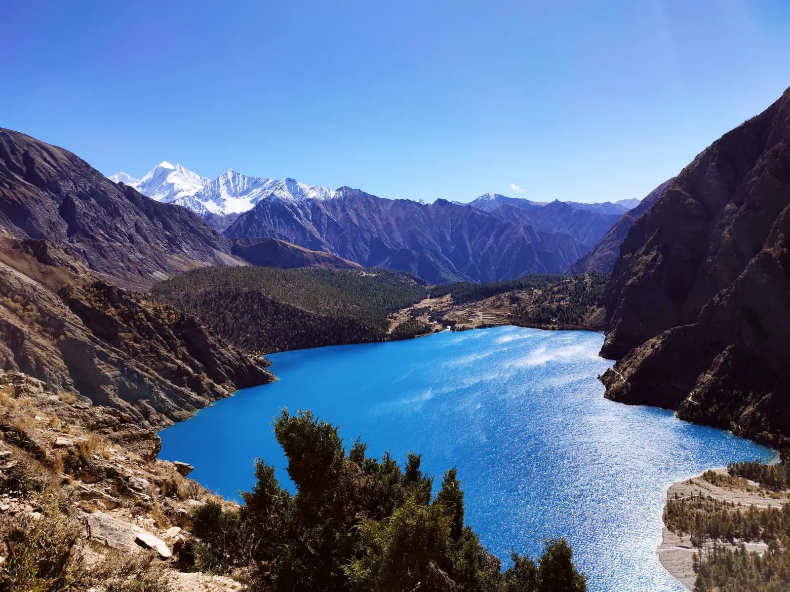
Phoksundo Lake Trek (Lower Dolpo)
A 10-day trek into Shey Phoksundo National Park to Ringmo and Phoksundo Lake, with flights to Juphal and no restricted-area permit.
- दिन10
- अधिकतम उचाइ३,६४० मि
- दूरी९०.४ कि.मि.
- उकालो४,५३५ मि
- कठिनाइमध्यम
- उत्तम महिनाApr–Jun, Sep–Nov
- अनुमतिपत्र2
यो यात्रा तालिकासहित ट्रिपको योजना बनाउनुहोस्Phoksundo Lake Trek (Lower Dolpo) का लागि साथी खोज्नुहोस्हप्ताअनुसार प्रस्थान हेर्नुहोस्
फोटो: Kiran Dhodari · CC BY 4.0
अंग्रेजीमा देखाइएको — अझै अनुवाद भएको छैन।
यो यात्रा तालिका मस्यौदा हो र अझै प्रमाणित भएको छैन। चरणहरू सधैं आफ्नो गाइडसँग पुष्टि गर्नुहोस्।
Written by FindTrekkingPartner teamFindTrekkingPartner team द्वारा समीक्षितहामी कसरी समीक्षा गर्छौंFindTrekkingPartner
Phoksundo Lake Trek (Lower Dolpo) नेपालको Dolpo क्षेत्रमा पर्ने 10 दिनको ट्रेक हो, जुन ३,६४० मिटरसम्म उक्लिन्छ। विदेशी ट्रेकरहरूले आफ्नो मिति, बजेट र गतिसहित ट्रिप पोस्ट गरेर FindTrekkingPartner मा यसका लागि साथी खोज्न सक्छन्। दुवै ट्रेकर सहमत नभएसम्म म्याचहरू निजी रहन्छन्, र सेवा निःशुल्क छ। मध्यम स्तरको दरमा, चार जना ट्रेकरले बाँड्दा 10 दिनको लागि इजाजतपत्रप्राप्त गाइडको खर्च प्रति व्यक्ति लगभग USD ९३ पर्छ, जबकि एक्लै जाँदा USD ३७३ पर्छ। उत्तम मौसमहरू May–Jun, Sep–Oct हुन्। यो प्रतिबन्धित क्षेत्र हो, त्यसैले दर्ता भएको एजेन्सीमार्फत लिइएको इजाजतपत्रप्राप्त गाइड परमिटकै हिस्सा हो, र पूरै समूह एउटै एजेन्सी परमिटमा यात्रा गर्छ। यस रुटका खुला ट्रिपहरू तल सूचीबद्ध छन्, सुरु हुने महिना, समूहको आकार र बाँकी स्थानसहित। पछिल्लो पटक पुष्टि गरिएको: २०२६ अक्टोबर १९। स्रोतहरू: नेपाल पर्यटन बोर्ड, DNPWC, अध्यागमन विभाग।
स्रोतहरू:Department of Immigration, NepalNepal Tourism BoardDepartment of National Parks and Wildlife Conservation
Phoksundo Lake Trek (Lower Dolpo) का लागि साथी खोज्नुहोस्
परिचय
Kathmandu बाट सुरु१० दिन · अधिकतम ३,६४० मि
उत्तम मौसम: Apr–Jun, Sep–Nov · अनुमतिपत्र: Shey Phoksundo National Park entry permit, TIMS card where required
The Phoksundo Lake trek is a 10-day journey into the lower valleys of Dolpo, in Dolpa District of north-west Nepal, ending beside one of the country's deepest and most beautiful lakes. It flies from Kathmandu to Nepalgunj and on to Juphal, walks along the Thuli Bheri and Suligad rivers through Dunai and Sulighat to Chhepka and Ringmo, spends a rest day at the lake at about 3,610 m, and returns the same way before the flights home. The walk covers about 90 km with 4,500 m of climbing and, unlike Upper Dolpo, needs no restricted-area permit, only the Shey Phoksundo National Park permit. It is a moderate trek with long days, simple lodges and a remote feel, suitable for fit walkers. April to June and September to November are the best months. Allow spare days for the flights, which are weather dependent.
What the trek is like
From Juphal the trail drops to Dunai, a small district town on the Thuli Bheri river, then follows the Suligad river into a deep, dry gorge. After the park entrance at Sulighat it climbs through blue pine, birch and juniper to Chhepka, a village of stone houses and fields. The last day to the lake climbs through forest and past waterfalls to a high saddle and the first view of Phoksundo, a turquoise lake in a bowl of rock and snow. Ringmo sits at the southern end, with chortens, a Bon monastery and flat-roofed houses. The return takes the same route in shorter days.
Highlights
- Phoksundo Lake, which covers about 494 hectares and was designated a Ramsar site in 2007
- The waterfall of about 167 m where the lake drains
- Ringmo village and its Bon monastery and chortens
- The Suligad gorge, dry forest and walnut and apple trees near Dunai
- A rest day with time to see the lake from several viewpoints
Permits and rules
You need the Shey Phoksundo National Park entry permit, arranged through your agency or bought at the checkpost, and a TIMS card where the local office asks for it. The Phoksundo trek is not a restricted-area trek. The Nepal Tourism Board April 2023 rule requires foreign trekkers to use a licensed guide in national parks and conservation areas, and 2026 operator reports say checkpoints enforce it in Annapurna (ACAP), Langtang (the strictest) and most other parks, but not in Khumbu, where the municipality opted out (checked 19 October 2026). See the guide rule by region. Ask for current fees and check them with the park or the Department of National Parks and Wildlife Conservation.
Best season
April to June and September to November are the best months. Spring has clearer air and flowers, and autumn brings stable weather. Dolpo lies in the rain shadow, so the monsoon is milder than elsewhere, but flights are often disrupted by cloud over Nepalgunj and the airstrip. Winter is cold, with snow around Ringmo and a frozen lake.
Altitude
Ringmo, at about 3,640 m, is the highest point. Chhepka (about 2,660 m) and Ringmo are separated by a long, steep climb of nearly 1,700 m, so take it slowly. The rest day at the lake helps acclimatisation, and you sleep at the same altitude. Watch for headache, nausea and poor sleep, never ascend with symptoms, and descend if they worsen. Discuss altitude medicine with your doctor.
Getting there and away
Fly Kathmandu to Nepalgunj, then Nepalgunj to Juphal on a small plane. The return reverses this. Both flights depend on weather, and Juphal flights are often delayed, so keep one or two spare days. There is no road to Ringmo.
Lodges, food and costs
Simple lodges operate at Juphal, Dunai, Chhepka and Ringmo, with dal bhat, noodles, eggs and tea. Rooms are basic, with blankets and sometimes heating, and hot showers are rare. Many agencies still provide tents and a cook for flexibility. Prices rise with altitude, and you should bring cash for the whole trek, because Dunai has few services.
Packing list
Broken-in boots, waterproof layers, a down jacket, a sleeping bag rated to about minus 10 C, gloves, hat, sunglasses, sun cream, trekking poles, a headlamp, water purification and a first-aid kit. A sun hat is useful, because the valley is bright and dry.
Who this trek suits and how to prepare
The trek suits fit walkers who want a remote trek without extreme altitude or a restricted-area permit. The days are long, with 20 to 25 km on two of them, so prepare with hill walks and some days with a loaded pack. Previous multi-day trekking is helpful.
The plan at a glance
Days 1 and 2 fly to Nepalgunj and Juphal. Day 3 walks to Chhepka and day 4 to Ringmo, with a rest day on day 5. Days 6 to 8 return to Chhepka, Dunai and Juphal, and days 9 and 10 fly back to Kathmandu via Nepalgunj.
Extensions
Add a day or two for weather at Juphal or Nepalgunj. For a longer trek, continue from Ringmo to Lar Tsa along the lake, or join the Upper Dolpo trek over the Kang La, which needs a restricted-area permit. You can also visit the Dunai bazaar and the monasteries near Juphal.
Practical tips from the trail
- Walking times in the day plan are estimates from distance and climb, checked against operator itineraries; real times differ with pace, load and weather.
- Keep spare days for the Juphal flights.
- Start early on the long climb from Chhepka to Ringmo.
- Carry sun protection and water, because the trail is dry and exposed.
- Respect the monasteries and walk clockwise around chortens.
- Do not swim or wash in the lake, which is sacred and protected.
Responsible trekking
Take rubbish out, use filtered water, avoid wood fires in the national park and buy from local families. Ask before photographing people and ceremonies.
मुख्य आकर्षण
- Phoksundo Lake, a Ramsar lake at about 3,610 m
- Ringmo, a Tibetan-style village beside the lake
- The 167 m waterfall at the lake outlet
- Dunai and the Thuli Bheri valley of lower Dolpo
- Bon and Buddhist monasteries, chortens and mani walls
मार्ग नक्सा
मार्गको डेटा OpenStreetMap बाट लिइएको हो, हाम्रो टोलीले अझै जाँचेको छैन। योजना बनाउन प्रयोग गर्नुहोस्, नेभिगेसनका लागि होइन।
दिनदिनको विवरण
तपाईं अघिल्लो रातभन्दा २,३३० मि माथि सुत्नुहुन्छ, जुन सामान्य ५०० मिटरको मार्गदर्शनभन्दा बढी हो। बिस्तारै हिँड्नुहोस्, प्रशस्त पानी पिउनुहोस् र टाउको दुखाइ वा वाकवाकी भए ध्यान दिनुहोस्।
Take the morning flight from Nepalgunj to Juphal, about 40 minutes on a small plane over green foothills and, on clear days, the Dhaulagiri range. The airstrip lies at about 2,490 m above Dunai, the district headquarters of Dolpa. The air is cool and dry after the plains. Meet your crew, show your permits at the checkpost and sort the loads. If the flight is cancelled, you spend another night in Nepalgunj, so plan flexible days. The trek starts tomorrow. Keep warm layers at hand, because the airstrip is cool.
A long first walking day from Juphal to Chhepka at about 2,660 m. The trail drops to the Thuli Bheri, passes through Dunai and follows the Suligad river to Sulighat, the entrance to Shey Phoksundo National Park, then climbs on to Chhepka. It is about 25 km with 1,150 m of climbing, taking 7 to 10 hours, so many groups split the day with a camp at Sulighat. The valley is dry and rocky, with blue pine and walnut trees. Chhepka has simple lodges.
तपाईं अघिल्लो रातभन्दा ९८० मि माथि सुत्नुहुन्छ, जुन सामान्य ५०० मिटरको मार्गदर्शनभन्दा बढी हो। बिस्तारै हिँड्नुहोस्, प्रशस्त पानी पिउनुहोस् र टाउको दुखाइ वा वाकवाकी भए ध्यान दिनुहोस्।
A hard day from Chhepka to Ringmo at about 3,640 m, about 20 km with 1,670 m of climbing, taking 6 to 9 hours. The trail follows the Suligad river through Rechi and Sanduwa, with steep rock steps, waterfalls and forest, then opens to the lake basin, where Phoksundo Lake comes into view at about 3,610 m. Ringmo is a village of flat-roofed stone houses, chortens and a Bon monastery. Rest, eat well and enjoy the first evening view of the lake.
A rest and acclimatisation day at Ringmo. Walk to the shore of Phoksundo Lake, about 3,610 m, and visit the monastery and chortens in Ringmo. The water is a deep turquoise, and the waterfall below the village drops about 167 m. Take short walks to viewpoints and enjoy the views of the Kanjiroba range, but keep a slow pace. Use the afternoon to rest and wash clothes. Avoid swimming or washing in the lake, which is sacred and protected. Take the afternoon off to rest and write notes.
Descend from Ringmo to Chhepka at about 2,660 m, about 20 km with 1,680 m of descent and 700 m of climbing, taking 6 to 8 hours. The route retraces the Suligad river through Sanduwa and Rechi, with waterfalls and forest, and the air warms as you drop. The steep steps are hard on the knees, so use poles and take breaks. Chhepka's lodges are simple but welcoming. Enjoy a hot meal and an early night after the long day. Check the weather forecast with your guide before bed.
Walk from Chhepka to Dunai at about 2,090 m, about 14.5 km with a climb of 420 m and a descent of 990 m, taking 4.5 to 6 hours. The trail follows the Suligad river through Sulighat, leaves the national park and ends in Dunai, the district town on the Thuli Bheri. Dunai has a bazaar, a hospital, a small gompa and basic lodges. Use the afternoon to walk around the town, buy snacks and sort your belongings. The climate is warmer and drier than at Ringmo.
A short walk from Dunai to Juphal at about 2,490 m, about 10 km with a climb of 560 m, taking 4 to 5 hours. The trail leaves the river and climbs through dry hills and villages to the airstrip, with views of the Thuli Bheri valley and the surrounding ranges. Juphal has a few lodges, and the airport office checks your flight status. Keep a spare day in the schedule in case the weather closes the airstrip. Pack your bags and prepare for the morning flight.
Fly from Juphal to Nepalgunj, about 40 minutes over foothills and valleys, and transfer to a hotel. The air is hot and humid after the high valleys, and you may want a shower and a cold drink. If the Kathmandu flight is the same day, you connect at the airport, otherwise use the afternoon to rest. Flights from Juphal are often delayed by cloud, so keep a buffer. Your agency will arrange the hotel and onward tickets. Keep your passport and flight tickets within easy reach.
तपाईं अघिल्लो रातभन्दा १,२४० मि माथि सुत्नुहुन्छ, जुन सामान्य ५०० मिटरको मार्गदर्शनभन्दा बढी हो। बिस्तारै हिँड्नुहोस्, प्रशस्त पानी पिउनुहोस् र टाउको दुखाइ वा वाकवाकी भए ध्यान दिनुहोस्।
Fly from Nepalgunj to Kathmandu, about an hour, and transfer to your hotel. The flight offers a last view of the Himalaya on clear mornings. Back in Kathmandu, you can shower, repack and explore Thamel or Patan. Keep a spare day after the trek in case of flight delays. Tip your guide and porters according to your agency's guidelines, and celebrate a short, remote journey to one of the most beautiful lakes in Nepal. Keep your passport and permit copies in your hand luggage for the airport checks.
अनुकूलन
रातैपिच्छे सुत्ने उचाइ। रातो पट्टीहरू अघिल्लो रातभन्दा ५०० मिटरभन्दा बढी चढेका हुन्; आराम दिन चिन्ह लगाइएको छ।
- सुत्ने उचाइ
- ५०० मिटरभन्दा बढी चढाइ
- आराम दिन
कति खर्च लाग्छ
प्रति व्यक्ति अनुमानित सबै-समेतको खर्च: उचाइअनुसार लज र खाना, यातायात, अनुमतिपत्र, र गाइड तथा पोर्टर। जति धेरै ट्रेकरले गाइड र पोर्टर बाँड्छन्, प्रत्येकले त्यति कम तिर्छन्। २०२६ अक्टोबर सम्मको अनुसार।
| शैली | १ ट्रेकर | २ ट्रेकर बाँडेर | ४ ट्रेकर बाँडेर |
|---|---|---|---|
| किफायती | US$ ३८०–US$ ५८०* | US$ ३८०–US$ ५८०* | US$ ३८०–US$ ५८०* |
| मध्यम | US$ ७२०–US$ १,१००* | US$ ५८०–US$ ८९०* | US$ ५४०–US$ ८२०* |
| आरामदायी | US$ ८००–US$ १,२५०* | US$ ७१०–US$ १,१००* | US$ ६७०–US$ १,०५०* |
गाइड बाँडेर पैसा बचाउनुहोस्
मध्यम स्तरमा, एक्लो ट्रेकरले करिब US$ ७२०–US$ १,१०० तिर्छ; एउटा गाइड र दुई पोर्टर बाँड्ने चार ट्रेकरले प्रत्येकले करिब US$ ५४०–US$ ८२० तिर्छन् (दायराको माथिल्लो छेउमा 25% कम)।
२ ट्रेकरले बाँड्दाको विवरण
| विवरण | किफायती | मध्यम | आरामदायी |
|---|---|---|---|
| लज र खाना | US$ १६०–US$ २८० | US$ २३०–US$ ३७० | US$ ३१०–US$ ४९० |
| यातायात | US$ २००–US$ २९० | US$ २००–US$ २९० | US$ २००–US$ २९० |
| अनुमतिपत्र | US$ २०–US$ ३० | US$ २०–US$ ३० | US$ २०–US$ ३० |
| गाइड | — | US$ ८०–US$ १४० | US$ ८०–US$ १४० |
| पोर्टर | — | US$ ४०–US$ ८० | US$ ९०–US$ १६० |
बजेटमा सार्वजनिक यातायात र पोर्टरबिना; मध्यम स्तरमा दुई ट्रेकरबीच एक पोर्टर र निजी सवारी साधन बाँडिन्छ; आरामदायीमा प्रत्येक ट्रेकरलाई एक पोर्टर। गाइड अनिवार्य भएको ठाउँमा वा मध्यम स्तर अथवा आरामदायी शैलीमा समावेश गरिएको हुन्छ।
रातको लज र खाना (कोठा र दाल भात)
५ रात Below 2,500 m: कोठा US$ २–US$ ९, दाल भात US$ ४–US$ ७ · ४ रात 2,500 to 3,800 m: कोठा US$ ४–US$ ११, दाल भात US$ ५–US$ ११
अनुमतिपत्र शुल्क (आधिकारिक स्रोत)
- Shey Phoksundo National Park entry permit: NPR ३,००० प्रति प्रवेश स्रोत
समावेश छैन
यिनको प्रकाशित मूल्य भेटिएन: Nepalgunj to Juphal flight (return)। * चिन्ह लागेका जम्मा रकममा यी छुटेका छन्; आफ्नो एजेन्सीसँग सोध्नुहोस्।
खर्चका स्रोतहरू
- PriceNepal: Nepal Travel Cost Guide 2026 (2026-05-14)
- Third Rock Adventures: Nepal trek budget planner (2026-05-09)
- Himalayan Partner: Guide and porter price in Nepal 2026 (2026-02-10)
- Shikhar Adventure: Annapurna Circuit trek cost (2026-02-03)
- Nepal Tourism Board: Trekking Permit (2026-10-18)
अपरेटर गाइडबाट लिइएका अनुमान हुन्, कोटेसन होइनन्। टिप, बीमा, सामान र काठमाडौंका होटल समावेश छैनन्; USD प्लेटफर्मको विनिमय दरमा।
फोटोहरू
प्रायः सोधिने प्रश्नहरू
No. Phoksundo and lower Dolpo need only the Shey Phoksundo National Park entry permit. Upper Dolpo, beyond the Kang La, is a restricted area.
The Nepal Tourism Board April 2023 rule requires foreign trekkers to use a licensed guide in national parks and conservation areas, and 2026 operator reports say checkpoints enforce it in Annapurna (ACAP), Langtang (the strictest) and most other parks, but not in Khumbu, where the municipality opted out (checked 19 October 2026). Confirm with a registered agency. A guide is advised on this remote trail in any case.
Ten days from Kathmandu on this plan, including the flights to Nepalgunj and Juphal, two days of walking to Ringmo, a rest day and three days of walking back. Flight delays can add days.
About 3,611 m. Ringmo village is at about 3,640 m, and the lake is among the deepest in Nepal, measured at 136 to 145 m in surveys.
April to June and September to November. The monsoon is milder in Dolpo, but flights are often delayed, and winter freezes the lake.
Moderate. The altitude is below 3,700 m, but two days are long at 20 to 25 km, and the climb from Chhepka to Ringmo is about 1,700 m.
No. The lake is sacred and protected, and washing or swimming is discouraged.
स्रोतहरू
- Phoksundo Lake Trek, 11 days (Trekking in Nepal)
- Phoksundo Lake Trekking (Himkala Adventure)
- Phoksundo Lake (Wikipedia)
- Shey Phoksundo National Park (Wikipedia)
- Dolpa District (Wikipedia)
- Department of National Parks and Wildlife Conservation, Nepal
- Nepal Tourism Board
- Himalayan Rescue Association
- OpenStreetMap (elevation tags of villages and the lake)
बाटोभरि
मार्गको हरेक दिन बास, चिकित्सा सहायता, पानी र हेर्नलायक ठाउँहरू।
1. Kathmandu → Nepalgunj
- त्रिभुवन अन्तर्राष्ट्रिय विमानस्थल · विमानस्थल र यातायात · १,३४० मि
Show all 2 places
- त्रिभुवन अन्तर्राष्ट्रिय विमानस्थल · विमानस्थल र यातायात · १,३४० मि
- Nepalgunj Airport · विमानस्थल र यातायात · १६५ मि
2. Nepalgunj → Juphal
यो दिनका लागि अहिलेसम्म केही नक्सांकन भएको छैन।यो दिनका लागि अहिलेसम्म केही नक्सांकन भएको छैन।3. Juphal → Chhepka
- Dolpa Airport · विमानस्थल र यातायात · २,४८९ मि
- Drinking Water · उपयोगी · २,०४४ मि
- Rupgar hotel · बास · २,०७० मि
- District hospital · चिकित्सा · २,०९० मि
- Thapa Hotel · बास · २,०९१ मि
- स्वास्थ्य चौकी कार्यालय परीला डोल्पा · चिकित्सा · २,५३५ मि
- Shyanta · बास · २,४९० मि
- Jharana Hotel · बास · २,६६६ मि
Show all 9 places
- Dolpa Airport · विमानस्थल र यातायात · २,४८९ मि
- Drinking Water · उपयोगी · २,०४४ मि
- Rupgar hotel · बास · २,०७० मि
- Army helipad · विमानस्थल र यातायात · २,१०३ मि
- District hospital · चिकित्सा · २,०९० मि
- Thapa Hotel · बास · २,०९१ मि
- स्वास्थ्य चौकी कार्यालय परीला डोल्पा · चिकित्सा · २,५३५ मि
- Shyanta · बास · २,४९० मि
- Jharana Hotel · बास · २,६६६ मि
4. Chhepka → Ringmo
- Shey Karnali Hotel · बास · ३,१२० मि
- Saijol Health Post · चिकित्सा · ३,११८ मि
- Phoksundo Hotel · बास · ३,१३२ मि
- Jharana Hotel · बास · ३,१३१ मि
5. Ringmo
- Stupid Hotel & Lounge · बास · ३,६२६ मि
- Shey Shikhahr Lakeside Hotel&Lodge · बास · ३,६३२ मि
- Himalayan Hotel & Lodge · बास · ३,६४१ मि
- Mount Kailash Guest House · बास · ३,६४० मि
- Drinking Water · उपयोगी · ३,६४० मि
- शे-फोक्सुन्डो ताल · प्रकृति · ३,६१२ मि
Show all 10 places
- Sherpa Hotel&Lodge · बास · ३,६४० मि
- Stupid Hotel & Lounge · बास · ३,६२६ मि
- Shey Shikhahr Lakeside Hotel&Lodge · बास · ३,६३२ मि
- Himalayan Hotel & Lodge · बास · ३,६४१ मि
- Mount Kailash Guest House · बास · ३,६४० मि
- Shey Phoksundo Hotel view point · बास · ३,६३७ मि
- Drinking Water · उपयोगी · ३,६४० मि
- Ringmo · बास · ३,६४० मि
- New tourist Guest House · बास · ३,६५० मि
- शे-फोक्सुन्डो ताल · प्रकृति · ३,६१२ मि
6. Ringmo → Chhepka
- Drinking Water · उपयोगी · ३,६४५ मि
- Viewpoint · दृश्यावलोकन स्थल · ३,६४७ मि
- Chunuwar Health Post · चिकित्सा · ३,१३६ मि
- Amchi Hospital · चिकित्सा · ३,१२९ मि
- Samshana Hotel · बास · ३,०५५ मि
- Hotel Pahuna Ghar · बास · ३,०३२ मि
- Keshang Hotel · बास · ३,०३२ मि
7. Chhepka → Dunai
- Hotel Swagat · बास · २,४९२ मि
- Sunita Hotel · बास · २,२८७ मि
8. Dunai → Juphal
- स्वास्थ्य सेवा कार्यालय, दुनई-डोल्पा · चिकित्सा · २,०८८ मि
- Dolpa District Hospital · चिकित्सा · २,०९० मि
- Drinking Water · उपयोगी · २,१७४ मि
- Hotel Tripura · बास · २,४८७ मि
- Hotel Mount Putha & Restaurant · बास · २,४७५ मि
- Dolpa Airport · विमानस्थल र यातायात · २,४९९ मि
- Mount putha · बास · २,४८२ मि
Show all 8 places
- स्वास्थ्य सेवा कार्यालय, दुनई-डोल्पा · चिकित्सा · २,०८८ मि
- Dolpa District Hospital · चिकित्सा · २,०९० मि
- Drinking Water · उपयोगी · २,१७४ मि
- Jufal health post · चिकित्सा · २,४३४ मि
- Hotel Tripura · बास · २,४८७ मि
- Hotel Mount Putha & Restaurant · बास · २,४७५ मि
- Dolpa Airport · विमानस्थल र यातायात · २,४९९ मि
- Mount putha · बास · २,४८२ मि
9. Juphal → Nepalgunj
यो दिनका लागि अहिलेसम्म केही नक्सांकन भएको छैन।यो दिनका लागि अहिलेसम्म केही नक्सांकन भएको छैन।10. Nepalgunj → Kathmandu
यो दिनका लागि अहिलेसम्म केही नक्सांकन भएको छैन।यो दिनका लागि अहिलेसम्म केही नक्सांकन भएको छैन।
अन्तिम पटक २०२६ अक्टोबर १९ मा प्रमाणितपुरानो जानकारी रिपोर्ट गर्नुहोस्