

Drive from Kathmandu to Besisahar and on up the Marsyangdi valley to Dharapani, at 1,860 m, a long day of nine to ten hours on winding roads. The valley is steep and green, with waterfalls and terraced villages, and the road continues beyond Besisahar on jeep track. Dharapani has a few lodges beside the river and is the junction with the trail to Manaslu. If you want an easier first day you can begin walking at Besisahar or Bulbule instead. Check your gear, drink plenty of water and get an early night; tomorrow's walk is the first full day on foot.
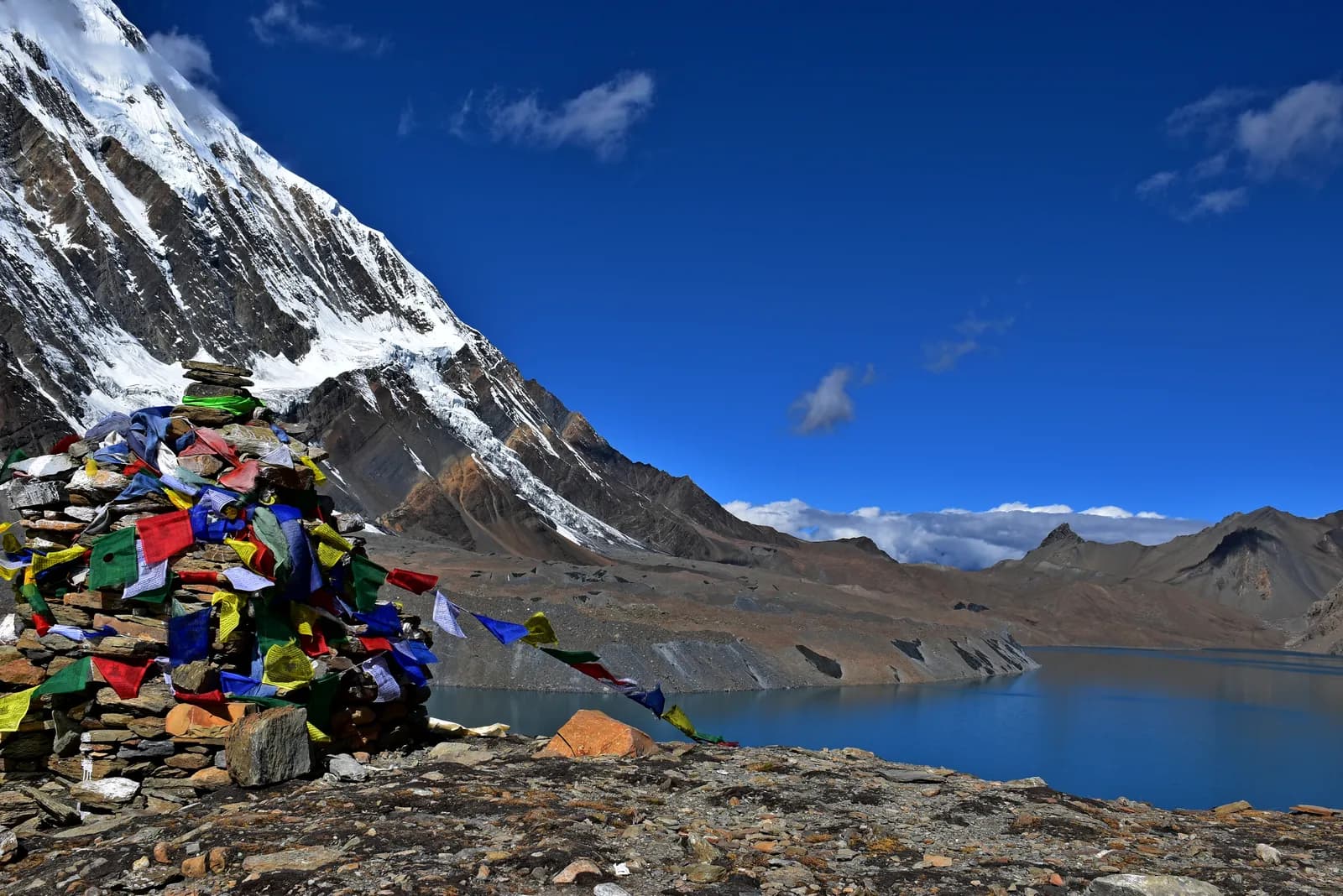
Tilicho Lake Trek
A 10-day Marsyangdi valley trek from Dharapani to Manang, then the loop to Tilicho Base Camp and the glacial lake at about 4,920 m.
- दिन10
- अधिकतम उचाइ४,९२० मि
- दूरी८७.८ कि.मि.
- उकालो५,३१६ मि
- कठिनाइकठिन
- उत्तम महिनाMar–May, Oct–Nov
- अनुमतिपत्र2
यो यात्रा तालिकासहित ट्रिपको योजना बनाउनुहोस्Tilicho Lake Trek का लागि साथी खोज्नुहोस्हप्ताअनुसार प्रस्थान हेर्नुहोस्
फोटो: Prabeshsdev · CC BY-SA 4.0
अंग्रेजीमा देखाइएको — अझै अनुवाद भएको छैन।
यो यात्रा तालिका मस्यौदा हो र अझै प्रमाणित भएको छैन। चरणहरू सधैं आफ्नो गाइडसँग पुष्टि गर्नुहोस्।
Written by FindTrekkingPartner teamFindTrekkingPartner team द्वारा समीक्षितहामी कसरी समीक्षा गर्छौंFindTrekkingPartner
Tilicho Lake Trek नेपालको Annapurna क्षेत्रमा पर्ने 10 दिनको ट्रेक हो, जुन ४,९२० मिटरसम्म उक्लिन्छ। विदेशी ट्रेकरहरूले आफ्नो मिति, बजेट र गतिसहित ट्रिप पोस्ट गरेर FindTrekkingPartner मा यसका लागि साथी खोज्न सक्छन्। दुवै ट्रेकर सहमत नभएसम्म म्याचहरू निजी रहन्छन्, र सेवा निःशुल्क छ। मध्यम स्तरको दरमा, चार जना ट्रेकरले बाँड्दा 10 दिनको लागि इजाजतपत्रप्राप्त गाइडको खर्च प्रति व्यक्ति लगभग USD ६३ पर्छ, जबकि एक्लै जाँदा USD २५० पर्छ। उत्तम मौसमहरू Mar–May, Oct–Nov हुन्। यहाँ व्यवहारमा इजाजतपत्रप्राप्त गाइड आवश्यक छ: २०२६ का सञ्चालकहरूका अनुसार नेपाल पर्यटन बोर्डको अप्रिल २०२३ को नियम राष्ट्रिय निकुञ्ज र संरक्षण क्षेत्रका चेकपोइन्टहरूमा लागू गरिन्छ, जसमा लाङटाङ सबैभन्दा कडा छ र अन्नपूर्णमा पनि जाँच हुन्छ (१९ अक्टोबर २०२६ मा जाँचिएको)। दर्ता भएको एजेन्सीमार्फत गाइड लिनुहोस् र उनीहरूसँग पुष्टि गर्नुहोस्। पछिल्लो पटक पुष्टि गरिएको: २०२६ अक्टोबर २१। स्रोतहरू: नेपाल पर्यटन बोर्ड, DNPWC, अध्यागमन विभाग।
स्रोतहरू:Department of Immigration, NepalNepal Tourism BoardDepartment of National Parks and Wildlife Conservation
Tilicho Lake Trek का लागि साथी खोज्नुहोस्
- Tilicho Lake Trek का लागि साथी खोज्नुहोस्५ खुला ट्रिपहरू
- Annapurna Base Camp Trek का लागि साथी खोज्नुहोस्२५ खुला ट्रिपहरू
- Annapurna Circuit Trek का लागि साथी खोज्नुहोस्४ खुला ट्रिपहरू
- Poon Hill Trek (Ghorepani) का लागि साथी खोज्नुहोस्३ खुला ट्रिपहरू
- Mardi Himal Trek का लागि साथी खोज्नुहोस्२७ खुला ट्रिपहरू
- Khopra Ridge Trek का लागि साथी खोज्नुहोस्अहिलेसम्म कुनै खुला ट्रिप छैन
परिचय
Kathmandu बाट सुरु१० दिन · अधिकतम ४,९२० मि
उत्तम मौसम: Mar–May, Oct–Nov · अनुमतिपत्र: Annapurna Conservation Area entry permit, TIMS card where required
Tilicho Lake is a glacial lake in Manang District, at about 4,920 m in our route data, reached by a side trip from Manang that has become a trek in its own right. This 10-day plan drives from Kathmandu to Dharapani, walks up the Marsyangdi valley through Chame, Upper Pisang and Ngawal to Manang, rests there for a day, then loops out to Khangsar, Tilicho Base Camp (about 4,140 m) and the lake before returning to Manang, where the trek ends. It is a serious high-altitude trek: the climb from Base Camp to the lake is about 800 m on loose scree, and a landslide zone between Shree Kharka and Base Camp is open but risky, so you cross early and take local advice. It suits fit walkers who have already acclimatised well in Manang and who want a guide for the exposed stretch.
What the trek is like
The first five days follow the same valley as the Annapurna Circuit, from wet forest and waterfalls below Chame to drier, Tibetan-style villages with chortens, mani walls and apple orchards. The high trail through Ghyaru and Ngawal gives long views of Annapurna II, Annapurna III, Gangapurna and Tilicho Peak. Beyond Manang the country turns bare and quiet. Lodges at Khangsar and Shree Kharka are simple and Base Camp is basic, with cold nights, short menus and limited charging, so bring a warm sleeping bag and cash.
How it is built
We model Tilicho as a stand-alone route that shares its approach with the Circuit: it uses the same road-and-trail stages as far as Manang and then adds the loop. Many trekkers instead add the lake as two or three extra days on the Circuit itself; if you want to carry on over Thorong La at 5,416 m afterwards, see the Annapurna Circuit route. Altitudes for Khangsar and Shree Kharka differ by more than 100 m between published itineraries, so treat the figures here as approximate and confirm the stages with your guide in Manang.
Permits, guide and season
You need an Annapurna Conservation Area entry permit and a TIMS card where required. The guide rule as we last checked it is this: a licensed guide through a registered agency is required in restricted areas (Department of Immigration) and, under the Nepal Tourism Board rule of April 2023, in national parks and conservation areas, where 2026 operator reports say checkpoints enforce it in Annapurna and Langtang but not in Khumbu (checked 19 October 2026). Tilicho is inside the conservation area, and the landslide section makes a guide sensible in any case. The best windows are March to May and October to November; snow can block the high sections in early spring and late autumn.
Sharing the trip
A guide and porter for the extra days are shared costs, which is why this route suits a small group. Post your dates, then agree the plan, turnaround time and what happens if someone has symptoms at altitude before you leave Manang.
मुख्य आकर्षण
- Tilicho Lake at about 4,920 m
- Ghyaru and Ngawal high trail
- Manang acclimatisation day
- Tilicho Base Camp (about 4,140 m)
- Landslide section crossed at first light
मार्ग नक्सा
मार्गको डेटा OpenStreetMap बाट लिइएको हो, हाम्रो टोलीले अझै जाँचेको छैन। योजना बनाउन प्रयोग गर्नुहोस्, नेभिगेसनका लागि होइन।
दिनदिनको विवरण
तपाईं अघिल्लो रातभन्दा ८१० मि माथि सुत्नुहुन्छ, जुन सामान्य ५०० मिटरको मार्गदर्शनभन्दा बढी हो। बिस्तारै हिँड्नुहोस्, प्रशस्त पानी पिउनुहोस् र टाउको दुखाइ वा वाकवाकी भए ध्यान दिनुहोस्।
Walk up the Marsyangdi valley through Bagarchhap, Danaque and Timang, where Manaslu and Peri Himal appear to the north. The path follows the road in places and keeps to the river in others; the forest of pine and oak thins as you climb. Chame, at 2,670 m, is the headquarters of Manang district and has a bank machine, shops and hot springs a short walk from the village. The air is thinner here, and the first views of Lamjung Himal and Annapurna II appear. Rest and watch the evening light on the peaks.
तपाईं अघिल्लो रातभन्दा ६३० मि माथि सुत्नुहुन्छ, जुन सामान्य ५०० मिटरको मार्गदर्शनभन्दा बढी हो। बिस्तारै हिँड्नुहोस्, प्रशस्त पानी पिउनुहोस् र टाउको दुखाइ वा वाकवाकी भए ध्यान दिनुहोस्।
Continue along the Marsyangdi, crossing to Bhratang and walking through a dry pine forest below the huge curved rock face of Paungda Danda. The valley opens at Dhikur Pokhari, with its views of Annapurna II, and the trail climbs to Upper Pisang, at 3,300 m, a village of stone houses above the road. The village has a small monastery and wide views. The landscape is now Tibetan in character, with chortens, prayer flags and apple orchards. Decide here whether to take the high trail through Ghyaru tomorrow; it is worth the effort.
Take the upper route from Upper Pisang, a steep climb through juniper to Ghyaru, at about 3,700 m, and onward along the ridge to Ngawal at 3,600 m. The path is one of the finest on the circuit: Annapurna II, Annapurna III, Gangapurna and Tilicho Peak fill the view south, and you can see the entire Manang valley below. The villages are old and the houses are stacked up the hillside. The lower route through Humde is faster but less scenic. The altitude gain is modest, but the path is steep, so go slowly and keep your water close.
Descend gently from Ngawal to Braka, pass Mugje, and walk into Manang, at 3,540 m, via the airstrip at Humde. Manang is a Tibetan-influenced village with stone alleys, bakeries and a small cinema, and the view of Gangapurna and Annapurna III from the lodges is spectacular. In the afternoon, visit the Himalayan Rescue Association post, which gives a talk on altitude sickness in the trekking seasons. It is a short day and a chance to rest, wash your clothes and explore. Drink water throughout, and watch for headaches.
Spend a full day in Manang before heading higher. Walk up to the viewpoint above Gangapurna Lake or climb toward Ice Lake (Kicho Tal) at about 4,600 m, then come back down to sleep at 3,540 m. The Tilicho loop takes you above 4,900 m, so treat this as the first half of your preparation, not a spare day. Visit the Himalayan Rescue Association post for its altitude talk, ask lodge owners and your guide how the trail beyond Shree Kharka looks this week, and settle on a turnaround time for the lake. If you had headaches or poor sleep here, stay another night or skip the lake.
Leave Manang for Khangsar, a small village above the Marsyangdi on the trail that branches toward Tilicho. Expect roughly four to six hours depending on whether you stop at Khangsar or press on to Shree Kharka, which sits a little higher; published itineraries give Khangsar at about 3,734 to 3,756 m. The country is drier and barer than the main valley, with long views back to Gangapurna and the Annapurna wall. Keep the day short and sleep low enough that the next climb feels manageable. Pay attention to how you feel, as tomorrow takes you past the landslide section and above 4,100 m.
Today you pass Shree Kharka and reach Tilicho Base Camp at about 4,140 m, a short day by distance but a serious one. Between Shree Kharka and Base Camp the path crosses a landslide zone that operators describe as open but risky, with wind and falling stones building later in the morning. Cross early, keep spacing between walkers, follow your guide and be ready to turn back if it looks worse than reported. Phone signal is patchy here. Base Camp lodging is basic and nights are cold, so arrive with enough time to warm up, eat and drink well and go to bed early.
तपाईं अघिल्लो रातभन्दा ७८० मि माथि सुत्नुहुन्छ, जुन सामान्य ५०० मिटरको मार्गदर्शनभन्दा बढी हो। बिस्तारै हिँड्नुहोस्, प्रशस्त पानी पिउनुहोस् र टाउको दुखाइ वा वाकवाकी भए ध्यान दिनुहोस्।
Start before dawn with a headlamp for the climb of about 800 m on loose scree to Tilicho Lake, listed at about 4,920 m in our route data. Go slowly, drink often and agree a turnaround time with your guide before you leave, because wind builds through the morning and the scree is unpleasant in a gale. At the top you look over a large, cold, blue lake in a bare glacial cirque with snow peaks around it, so plan time for photos and a hot drink if the lodge there is open. Descend carefully and aim to be back at Base Camp for an early-afternoon lunch and a second night at 4,140 m.
Walk back down toward Manang at 3,540 m, crossing the landslide section again, so start early and keep the same discipline as on the way up. Operators vary on how they split the return: some go straight back, others sleep at Shree Kharka or Khangsar. Agree it with your guide the evening before, based on how the group feels and what the trail looks like. In Manang you rejoin the main Circuit trail; from here you can continue toward Yak Kharka and Thorong La if you have the time and are well, or head back down the Marsyangdi valley by road.
अनुकूलन
रातैपिच्छे सुत्ने उचाइ। रातो पट्टीहरू अघिल्लो रातभन्दा ५०० मिटरभन्दा बढी चढेका हुन्; आराम दिन चिन्ह लगाइएको छ।
- सुत्ने उचाइ
- ५०० मिटरभन्दा बढी चढाइ
- आराम दिन
कति खर्च लाग्छ
प्रति व्यक्ति अनुमानित सबै-समेतको खर्च: उचाइअनुसार लज र खाना, यातायात, अनुमतिपत्र, र गाइड तथा पोर्टर। जति धेरै ट्रेकरले गाइड र पोर्टर बाँड्छन्, प्रत्येकले त्यति कम तिर्छन्। २०२६ अक्टोबर सम्मको अनुसार।
| शैली | १ ट्रेकर | २ ट्रेकर बाँडेर | ४ ट्रेकर बाँडेर |
|---|---|---|---|
| किफायती | US$ ५१०–US$ ७३०* | US$ ४००–US$ ५८०* | US$ ३५०–US$ ५१०* |
| मध्यम | US$ १,०००–US$ १,५००* | US$ ६८०–US$ ९८०* | US$ ५५०–US$ ८००* |
| आरामदायी | US$ १,०५०–US$ १,६००* | US$ ८३०–US$ १,२५०* | US$ ७१०–US$ १,०५०* |
गाइड बाँडेर पैसा बचाउनुहोस्
मध्यम स्तरमा, एक्लो ट्रेकरले करिब US$ १,०००–US$ १,५०० तिर्छ; एउटा गाइड र दुई पोर्टर बाँड्ने चार ट्रेकरले प्रत्येकले करिब US$ ५५०–US$ ८०० तिर्छन् (दायराको माथिल्लो छेउमा 46% कम)।
२ ट्रेकरले बाँड्दाको विवरण
| विवरण | किफायती | मध्यम | आरामदायी |
|---|---|---|---|
| लज र खाना | US$ २५०–US$ ३५० | US$ ३१०–US$ ४५० | US$ ३९०–US$ ५६० |
| यातायात | US$ १०–US$ ५० | US$ १४०–US$ २३० | US$ १४०–US$ २३० |
| अनुमतिपत्र | US$ ३०–US$ ४० | US$ ३०–US$ ४० | US$ ३०–US$ ४० |
| गाइड | US$ १००–US$ १५० | US$ १००–US$ १५० | US$ १००–US$ १५० |
| पोर्टर | — | US$ ७०–US$ १३० | US$ १५०–US$ २६० |
बजेटमा सार्वजनिक यातायात र पोर्टरबिना; मध्यम स्तरमा दुई ट्रेकरबीच एक पोर्टर र निजी सवारी साधन बाँडिन्छ; आरामदायीमा प्रत्येक ट्रेकरलाई एक पोर्टर। गाइड अनिवार्य भएको ठाउँमा वा मध्यम स्तर अथवा आरामदायी शैलीमा समावेश गरिएको हुन्छ।
रातको लज र खाना (कोठा र दाल भात)
१ रात Below 2,500 m: कोठा US$ २–US$ ६, दाल भात US$ ४–US$ ७ · ७ रात 2,500 to 3,800 m: कोठा US$ ४–US$ ९, दाल भात US$ ५–US$ ९ · २ रात Above 3,800 m: कोठा US$ १०–US$ १५, दाल भात US$ १०–US$ १२
अनुमतिपत्र शुल्क (आधिकारिक स्रोत)
समावेश छैन
यिनको प्रकाशित मूल्य भेटिएन: Besisahar to Dharapani jeep; Manang to Besisahar jeep। * चिन्ह लागेका जम्मा रकममा यी छुटेका छन्; आफ्नो एजेन्सीसँग सोध्नुहोस्।
खर्चका स्रोतहरू
- PriceNepal: Nepal Travel Cost Guide 2026 (2026-05-14)
- Third Rock Adventures: Nepal trek budget planner (2026-05-09)
- Himalayan Partner: Guide and porter price in Nepal 2026 (2026-02-10)
- Shikhar Adventure: Annapurna Circuit trek cost (2026-02-03)
अपरेटर गाइडबाट लिइएका अनुमान हुन्, कोटेसन होइनन्। टिप, बीमा, सामान र काठमाडौंका होटल समावेश छैनन्; USD प्लेटफर्मको विनिमय दरमा।
फोटोहरू
प्रायः सोधिने प्रश्नहरू
About 4,919 m according to Wikipedia, with another source giving 4,949 m; our route data uses about 4,920 m. Tilicho Base Camp is usually given as about 4,140 m.
One section between Shree Kharka and Base Camp crosses a landslide zone that operators describe as open but risky, with wind and rockfall later in the morning. Cross early, follow your guide and check the current condition in Manang.
Our route data lists an Annapurna Conservation Area entry permit and a TIMS card where required, the same as the Annapurna Circuit. Ask your agency whether anything else applies.
Tilicho is inside the Annapurna Conservation Area, where 2026 operator reports say checkpoints enforce the guide rule (checked 19 October 2026). The landslide section makes a guide sensible regardless.
March to May and October to November, the same windows as the Circuit. Snow can block the high sections in early spring and late autumn.
Yes. Many trekkers add it as two or three extra days from Manang and then continue toward Thorong La; this route covers the lake as its own trek.
स्रोतहरू
बाटोभरि
मार्गको हरेक दिन बास, चिकित्सा सहायता, पानी र हेर्नलायक ठाउँहरू।
1. Kathmandu → Dharapani
- त्रिभुवन अन्तर्राष्ट्रिय विमानस्थल · विमानस्थल र यातायात · १,३४० मि
2. Dharapani → Chame
- Hayenga Waterfall · प्रकृति · २,०५३ मि
- Viewpoint · दृश्यावलोकन स्थल · १,८४० मि
- ACAP Safe Drinking Water Station · उपयोगी · २,१६२ मि
- Hotel Four Seasons · बास · २,६७६ मि
- Moonlight Hotel · बास · २,६७६ मि
- Hotel Manasulu View · बास · २,६७८ मि
- Trekkers Holiday Holtel · बास · २,६७८ मि
Show all 23 places
- Hayenga Waterfall · प्रकृति · २,०५३ मि
- Manaslu Hotel Restaurant · बास · १,८२० मि
- Hayat Guest House · बास · १,८१८ मि
- Viewpoint · दृश्यावलोकन स्थल · १,८४० मि
- Peaceful Hotel · बास · १,८७६ मि
- Gyasumda Hotel & Restaurant · बास · १,८७७ मि
- Dafne Hotel · बास · १,८८१ मि
- Marsyangdi Lodge · बास · २,०७६ मि
- Pasang · बास · २,०८२ मि
- Eco Holiday home · बास · २,०८१ मि
- Tilicho Hotel · बास · २,०९९ मि
- ACAP Safe Drinking Water Station · उपयोगी · २,१६२ मि
- Hotel Manaslu · बास · २,१७२ मि
- Mt Kailash · बास · २,२०० मि
- Potala · बास · २,२०८ मि
- Happy Home Cottage · बास · २,६०१ मि
- Tibet Lhasa Guest House · बास · २,६०१ मि
- Snowland Hotel · बास · २,६०२ मि
- Hotel Four Seasons · बास · २,६७६ मि
- Moonlight Hotel · बास · २,६७६ मि
- Hotel Manasulu View · बास · २,६७८ मि
- Trekkers Holiday Holtel · बास · २,६७८ मि
- Potala Guest House & Restaurant · बास · २,६८० मि
3. Chame → Upper Pisang
- Chame Hot springs · प्रकृति · २,६९७ मि
- Manang District Hospital · चिकित्सा · २,७३२ मि
- Viewpoint · दृश्यावलोकन स्थल · २,५१६ मि
- Drinking Water · उपयोगी · ३,८०१ मि
- Hotel Nirvana · बास · ३,२८१ मि
- Hotel Narbulinka Pisang · बास · ३,२९१ मि
- Hotel Royal Nyeshang · बास · ३,२९० मि
- Hotel Alobar 3300 · बास · ३,२८८ मि
Show all 24 places
- Hotel Marshyangdi Mandala · बास · २,६६४ मि
- Chame Hot springs · प्रकृति · २,६९७ मि
- Royal Garden Hotel · बास · २,६७० मि
- Manang District Hospital · चिकित्सा · २,७३२ मि
- Sangso Guest House · बास · २,६७३ मि
- White Stupa · बास · २,६९० मि
- Happy Guest House · बास · २,६९६ मि
- New Mount View · बास · २,७७४ मि
- Talekhu · बास · २,७७६ मि
- Campsite · बास · २,६९४ मि
- Viewpoint · दृश्यावलोकन स्थल · २,५१६ मि
- Drinking Water · उपयोगी · ३,८०१ मि
- Sworgadwari Hotel & Restaurant · बास · ३,१८८ मि
- Gangapurna · बास · ३,१८६ मि
- Kamala · बास · ३,१९७ मि
- Maya Hotel & Restaurant · बास · ३,१८६ मि
- Hotel Nirvana · बास · ३,२८१ मि
- Hotel Narbulinka Pisang · बास · ३,२९१ मि
- Hotel Royal Nyeshang · बास · ३,२९० मि
- Hotel Alobar 3300 · बास · ३,२८८ मि
- Hilltop Hotel Upper Pisang · बास · ३,२९८ मि
- Happiness Guest house · बास · ३,३०३ मि
- Royal mountain · बास · ३,३१० मि
- Hotel Mountain Bridge · बास · ३,३२६ मि
4. Upper Pisang → Ngawal
- Viewpoint · दृश्यावलोकन स्थल · ३,३०१ मि
- Green lake · प्रकृति · ३,२६२ मि
- Water tap (Disfunctional July 2019) · उपयोगी · ३,४४९ मि
- Drinking Water · उपयोगी · ३,६०३ मि
- Nagwal Cottage · बास · ३,६५८ मि
- Himalaya Hotel · बास · ३,६५७ मि
- New Annapurna · बास · ३,६५१ मि
- Tibet Guest House & Restaurant · बास · ३,६७१ मि
Show all 18 places
- Campsite · बास · ३,४२२ मि
- Viewpoint · दृश्यावलोकन स्थल · ३,३०१ मि
- Hotel Mringkyo · बास · ३,२६६ मि
- Green lake · प्रकृति · ३,२६२ मि
- Camping · बास · ३,२७१ मि
- Water tap (Disfunctional July 2019) · उपयोगी · ३,४४९ मि
- Drinking Water · उपयोगी · ३,६०३ मि
- Pema guest house · बास · ३,६९७ मि
- Yak Ru Hotel · बास · ३,७०२ मि
- Gorkhali Hotel · बास · ३,७०४ मि
- Annapurna Hotel · बास · ३,७१६ मि
- New Annapurna guest house · बास · ३,७२१ मि
- Hôtel Mount View · बास · ३,६६५ मि
- Nagwal Cottage · बास · ३,६५८ मि
- Himalaya Hotel · बास · ३,६५७ मि
- New Annapurna · बास · ३,६५१ मि
- मनांग विमान स्थल · विमानस्थल र यातायात · ३,३५३ मि
- Tibet Guest House & Restaurant · बास · ३,६७१ मि
5. Ngawal → Manang
- होटेल मनाङ्ग · बास · ३,५३३ मि
- Hotel Mountain Lake · बास · ३,५३७ मि
- Hotel Nilgiri · बास · ३,५३९ मि
- HRA Manang Aid Post · चिकित्सा · ३,५४० मि
- साफा पिउनी पानी · उपयोगी · ३,५५० मि
- Hotel Marsyangdi · बास · ३,५४५ मि
- ACAP Safe Drinking Water Station · उपयोगी · ३,५५० मि
- स्स्वस्थ्य चौकी · चिकित्सा · ३,५५८ मि
Show all 21 places
- Buddha Kitchen Hotel · बास · ३,६५८ मि
- Royal Nyeshyang · बास · ३,६५५ मि
- Ngawal · बास · ३,६७३ मि
- Shanti Hotel · बास · ३,६७५ मि
- Viewpoint · दृश्यावलोकन स्थल · ३,६३२ मि
- Namaste trekkers homestay · बास · ३,४८५ मि
- होटेल मनाङ्ग · बास · ३,५३३ मि
- Hotel Mountain Lake · बास · ३,५३७ मि
- Hotel Nilgiri · बास · ३,५३९ मि
- HRA Manang Aid Post · चिकित्सा · ३,५४० मि
- साफा पिउनी पानी · उपयोगी · ३,५५० मि
- Hotel Marsyangdi · बास · ३,५४५ मि
- Hotel Royal Manang · बास · ३,५५२ मि
- Moon Light Hotel & Restaurant · बास · ३,५५० मि
- ACAP Safe Drinking Water Station · उपयोगी · ३,५५० मि
- Moon Light hotel · बास · ३,५५० मि
- Alpine home · बास · ३,५४४ मि
- Hotel North Pole · बास · ३,५५० मि
- स्स्वस्थ्य चौकी · चिकित्सा · ३,५५८ मि
- Ghyalchan & Sister · बास · ३,५४३ मि
- Ghale guest house · बास · ३,५४४ मि
6. Manang
यो दिनका लागि अहिलेसम्म केही नक्सांकन भएको छैन।यो दिनका लागि अहिलेसम्म केही नक्सांकन भएको छैन।7. Manang → Khangsar
- Viewpoint · दृश्यावलोकन स्थल · ३,५९४ मि
- Path Manang - Khangsar · दृश्यावलोकन स्थल · ३,६६३ मि
- Khangsar health post · चिकित्सा · ३,७५३ मि
- Norbu Ling Hotel · बास · ३,७४७ मि
- Maya Hotel · बास · ३,७४५ मि
- Soni homestay · बास · ३,७५३ मि
- Khangsar Home · बास · ३,७५४ मि
Show all 9 places
- Thorong La · बास · ३,५४९ मि
- Manaslu · बास · ३,५५४ मि
- Viewpoint · दृश्यावलोकन स्थल · ३,५९४ मि
- Path Manang - Khangsar · दृश्यावलोकन स्थल · ३,६६३ मि
- Khangsar health post · चिकित्सा · ३,७५३ मि
- Norbu Ling Hotel · बास · ३,७४७ मि
- Maya Hotel · बास · ३,७४५ मि
- Soni homestay · बास · ३,७५३ मि
- Khangsar Home · बास · ३,७५४ मि
8. Khangsar → Tilicho Base Camp
- Viewpoint · दृश्यावलोकन स्थल · ३,९०५ मि
- Mountain eco cottage · बास · ४,०६६ मि
- Hotel mountain view · बास · ४,१३० मि
- New Zambala · बास · ४,१३५ मि
- Sweet Home · बास · ४,१३९ मि
Show all 7 places
- Viewpoint · दृश्यावलोकन स्थल · ३,९०५ मि
- Mountain eco cottage · बास · ४,०६६ मि
- Himalayan Hotel · बास · ४,०६७ मि
- possible Campsite · बास · ४,२२२ मि
- Hotel mountain view · बास · ४,१३० मि
- New Zambala · बास · ४,१३५ मि
- Sweet Home · बास · ४,१३९ मि
9. Tilicho Base Camp
- Hotel Khangsar Kang · बास · ४,१३६ मि
- New Hotel Moon Lake · बास · ४,१३७ मि
- Khangsar health post · चिकित्सा · ४,१४८ मि
- Viewpoint · दृश्यावलोकन स्थल · ४,४२३ मि
10. Tilicho Base Camp → Manang
- Hotel New Himalayan · बास · ४,१३७ मि
- Hotel Himalayan · बास · ४,१३९ मि
- Hotel Basecamp Inn · बास · ४,१३६ मि
- Stream · उपयोगी · ४,२३१ मि
- Viewpoint · दृश्यावलोकन स्थल · ३,९४६ मि
- Drinking Water · उपयोगी · ३,७४३ मि
- Xchongla Homestay · बास · ३,५४७ मि
Show all 15 places
- Hotel New Himalayan · बास · ४,१३७ मि
- Hotel Himalayan · बास · ४,१३९ मि
- Hotel Basecamp Inn · बास · ४,१३६ मि
- New Norbu Ling Hotel · बास · ४,१३१ मि
- New Tilicho Lake Base Camp Hotel · बास · ४,१३७ मि
- Stream · उपयोगी · ४,२३१ मि
- Blue Sheep · बास · ४,१७८ मि
- Hotel Tilicho Peak and Restaurant · बास · ४,०७० मि
- Viewpoint · दृश्यावलोकन स्थल · ३,९४६ मि
- Laxmi Guest House · बास · ३,७५१ मि
- Himalchuli Laxmi Hotel · बास · ३,७४७ मि
- Drinking Water · उपयोगी · ३,७४३ मि
- Hotel Mountain Yak · बास · ३,७४१ मि
- Potala · बास · ३,७४१ मि
- Xchongla Homestay · बास · ३,५४७ मि
अन्तिम पटक २०२६ अक्टोबर २१ मा प्रमाणितपुरानो जानकारी रिपोर्ट गर्नुहोस्