

Drive from Kathmandu to Besisahar, the headquarters of Lamjung District at about 760 m, about 6 to 7 hours along the Prithvi Highway and the Marsyangdi valley, with views of terraced hills and rivers. Besisahar is the traditional start of the Annapurna Circuit and has hotels and shops. Check your permits with your guide, buy any last supplies and rest. The jeep road continues tomorrow into the mountains. If the road is blocked by landslides, you may need a spare day. Buy snacks and cash before leaving the city.
Nar Phu Valley Trek
An 11-day restricted-area loop from Koto up the Nar Phu gorge to Phu and Nar, over the Kang La at about 5,300 m to Ngawal, with road access from Besisahar.
- दिन11
- अधिकतम उचाइ५,३०६ मि
- दूरी८२.४ कि.मि.
- उकालो७,०७५ मि
- कठिनाइकठिन
- उत्तम महिनाSep–Nov, Mar–May
- अनुमतिपत्र3
यो यात्रा तालिकासहित ट्रिपको योजना बनाउनुहोस्Nar Phu Valley Trek का लागि साथी खोज्नुहोस्हप्ताअनुसार प्रस्थान हेर्नुहोस्
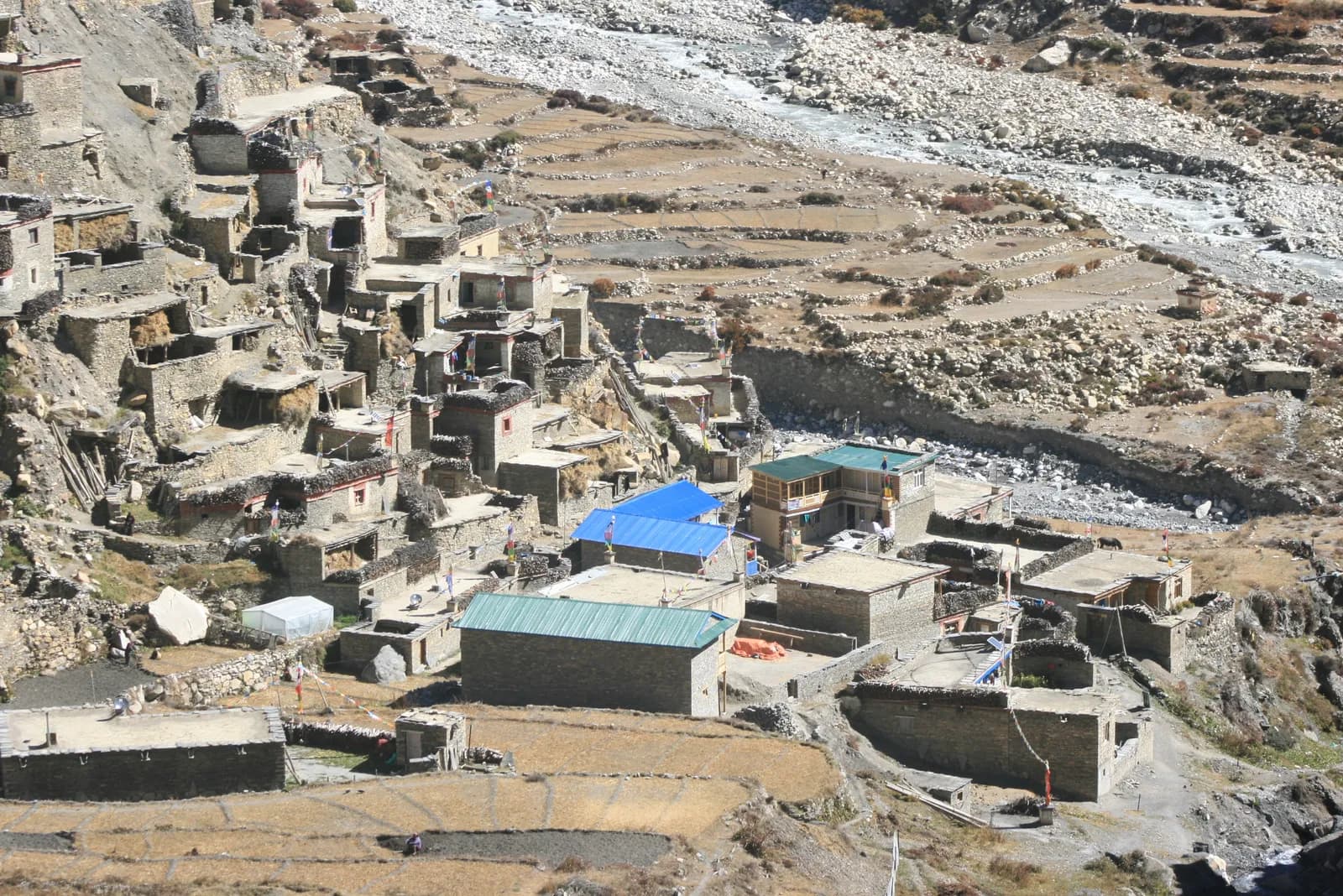
फोटो: Sharadgurung7711 · CC BY-SA 4.0
अंग्रेजीमा देखाइएको — अझै अनुवाद भएको छैन।
यो यात्रा तालिका मस्यौदा हो र अझै प्रमाणित भएको छैन। चरणहरू सधैं आफ्नो गाइडसँग पुष्टि गर्नुहोस्।
Written by FindTrekkingPartner teamFindTrekkingPartner team द्वारा समीक्षितहामी कसरी समीक्षा गर्छौंFindTrekkingPartner
Nar Phu Valley Trek नेपालको Annapurna क्षेत्रमा पर्ने 11 दिनको ट्रेक हो, जुन ५,३०६ मिटरसम्म उक्लिन्छ। विदेशी ट्रेकरहरूले आफ्नो मिति, बजेट र गतिसहित ट्रिप पोस्ट गरेर FindTrekkingPartner मा यसका लागि साथी खोज्न सक्छन्। दुवै ट्रेकर सहमत नभएसम्म म्याचहरू निजी रहन्छन्, र सेवा निःशुल्क छ। मध्यम स्तरको दरमा, चार जना ट्रेकरले बाँड्दा 11 दिनको लागि इजाजतपत्रप्राप्त गाइडको खर्च प्रति व्यक्ति लगभग USD ६९ पर्छ, जबकि एक्लै जाँदा USD २७५ पर्छ। उत्तम मौसमहरू Mar–May, Oct–Nov हुन्। यहाँ व्यवहारमा इजाजतपत्रप्राप्त गाइड आवश्यक छ: २०२६ का सञ्चालकहरूका अनुसार नेपाल पर्यटन बोर्डको अप्रिल २०२३ को नियम राष्ट्रिय निकुञ्ज र संरक्षण क्षेत्रका चेकपोइन्टहरूमा लागू गरिन्छ, जसमा लाङटाङ सबैभन्दा कडा छ र अन्नपूर्णमा पनि जाँच हुन्छ (१९ अक्टोबर २०२६ मा जाँचिएको)। दर्ता भएको एजेन्सीमार्फत गाइड लिनुहोस् र उनीहरूसँग पुष्टि गर्नुहोस्। पछिल्लो पटक पुष्टि गरिएको: २०२६ अक्टोबर २१। स्रोतहरू: नेपाल पर्यटन बोर्ड, DNPWC, अध्यागमन विभाग।
स्रोतहरू:Department of Immigration, NepalNepal Tourism BoardDepartment of National Parks and Wildlife Conservation
Nar Phu Valley Trek का लागि साथी खोज्नुहोस्
- Nar Phu Valley Trek का लागि साथी खोज्नुहोस्अहिलेसम्म कुनै खुला ट्रिप छैन
- Annapurna Base Camp Trek का लागि साथी खोज्नुहोस्२५ खुला ट्रिपहरू
- Annapurna Circuit Trek का लागि साथी खोज्नुहोस्४ खुला ट्रिपहरू
- Poon Hill Trek (Ghorepani) का लागि साथी खोज्नुहोस्३ खुला ट्रिपहरू
- Tilicho Lake Trek का लागि साथी खोज्नुहोस्५ खुला ट्रिपहरू
- Mardi Himal Trek का लागि साथी खोज्नुहोस्२७ खुला ट्रिपहरू
परिचय
Kathmandu बाट सुरुपासहरू: Kang La११ दिन · अधिकतम ५,३०६ मि
उत्तम मौसम: Sep–Nov, Mar–May · अनुमतिपत्र: Nar Phu restricted area permit (Department of Immigration, via a registered agency), Annapurna Conservation Area entry permit, TIMS card where required
The Nar Phu Valley trek is an 11-day loop through a remote restricted valley on the north side of the Annapurna range, in Manang District. It drives from Kathmandu to Besisahar and on to Koto, climbs through the Nar Phu gorge to Meta, Kyang and Phu, crosses to Nar, and returns over the Kang La at about 5,306 m to Ngawal and Manang, before the drive back. The route covers about 82 km on foot with large daily climbs and a gain of about 7,000 m according to the elevation model, so it is a hard trek. The valley is a restricted area inside the Annapurna Conservation Area, so you need a Restricted Area Permit through a registered agency, the conservation area permit and a licensed guide. The best months are September to November, and March to May. It suits fit trekkers who want Tibetan culture and a quiet valley and can handle a high pass.
What the trek is like
The trail leaves the Marsyangdi valley at Koto and enters a steep gorge of cliffs and pine forest, crossing bridges high above the Nar Phu Khola. After Meta the valley opens, and the villages of Kyang and Phu appear, with stone houses, chortens and fields at about 4,100 m. Phu has an old monastery and a view of Himlung Himal. The trail then crosses to Nar, a larger village with a gompa, and climbs to the Kang La, from which views of the Annapurna range open. The descent to Ngawal reaches the main Annapurna Circuit trail, and the last day follows it to Manang.
Highlights
- Phu village and Phu Gompa, with old Tibetan-style houses and chortens
- Nar village and its monastery
- The Nar Phu gorge, a deep, narrow canyon of cliffs and waterfalls
- The Kang La, with views of Annapurna II, Annapurna IV and Gangapurna
- Blue sheep, and possible snow leopard signs on the high slopes
Permits and rules
The Nar Phu valley is a restricted area. You need a Restricted Area Permit from the Department of Immigration, issued through a registered agency, an Annapurna Conservation Area entry permit and a TIMS card where required. A licensed guide must accompany you. Reports of a March 2026 notice say individual foreigners may apply, but the permit still needs an agency and a guide. Fees and day counts have changed more than once, so ask the agency for the current amounts and check them with the Department of Immigration. Carry several copies of your passport and permits for check posts.
Best season
September to November have the clearest weather, and March to May are possible, but the Kang La may hold snow in early spring. The monsoon is wetter on the south side and quieter in this rain-shadow valley, but landslides can block the road. Winter is very cold, with heavy snow on the pass.
Altitude
The plan sleeps at Meta (about 3,560 m), Phu (about 4,080 m, with a rest day) and Nar (about 4,110 m, with a rest day), before the Kang La at about 5,306 m. The pass day gains about 1,100 m and descends about 1,600 m, so it is long and tiring. Watch for headache, nausea and poor sleep, never ascend with symptoms, and descend if they worsen. Discuss altitude medicine with your doctor.
Getting there and away
Drive from Kathmandu to Besisahar (6 to 7 hours) and continue by jeep along the Marsyangdi road to Koto, about 6 to 7 hours more. The return from Manang to Besisahar by jeep takes 8 to 9 hours on a rough road, followed by the drive to Kathmandu. Landslides can cause delays, so keep a spare day.
Lodges, food and costs
Simple lodges and homestays operate in Meta, Kyang, Phu and Nar, with dal bhat, noodles, tsampa and tea. Facilities are basic, and some agencies carry tents and a cook for flexibility. Prices rise with altitude, and you should bring cash for the whole trek, because there are no machines beyond Besisahar and Manang.
Packing list
Broken-in boots, waterproof layers, a down jacket, a sleeping bag rated to about minus 15 C, gloves, hat, sunglasses, sun cream, gaiters, trekking poles, a headlamp, water purification and a first-aid kit. A pair of microspikes can help on the Kang La if snow lies.
Who this trek suits and how to prepare
The trek suits fit trekkers who like culture and remote valleys and are comfortable with long days at altitude. Prepare with hill walks, stair training and some days with a loaded pack. The pass day of about 15 km needs good stamina.
The plan at a glance
Days 1 and 2 drive to Besisahar and Koto. Days 3 and 4 walk to Meta and Phu, with a rest day on day 5. Day 6 walks to Nar and day 7 is a rest day. Day 8 crosses the Kang La to Ngawal and day 9 walks to Manang. Days 10 and 11 drive to Besisahar and Kathmandu.
Extensions
From Manang you can continue over the Thorong La to Muktinath and Jomsom on the Annapurna Circuit, which adds about a week. Others add a side trip to Tilicho Lake or a day at Manang, or combine the trek with a short stay in Pokhara.
Practical tips from the trail
- Walking times in the day plan are estimates from distance and climb, checked against operator itineraries; real times differ with pace, load and weather.
- Start early on the Kang La day, with food, water and warm layers.
- Check the snow with your guide before leaving Nar.
- Keep a spare day for the Marsyangdi road.
- Respect monasteries and walk clockwise around chortens.
- Carry cash in small notes, as villages have no machines.
Responsible trekking
Take rubbish out, use filtered water, buy from local families and respect the valley's customs. Do not give sweets or money to children.
मुख्य आकर्षण
- Phu and Nar, Tibetan-style villages at about 4,100 m in a restricted valley
- The Nar Phu gorge, with cliffs, suspension bridges and waterfalls
- The Kang La at about 5,306 m, with views of the Annapurna range
- Phu Gompa and old stone houses and chortens
- A quiet, remote alternative to the Annapurna Circuit
मार्ग नक्सा
मार्गको डेटा OpenStreetMap बाट लिइएको हो, हाम्रो टोलीले अझै जाँचेको छैन। योजना बनाउन प्रयोग गर्नुहोस्, नेभिगेसनका लागि होइन।
दिनदिनको विवरण
तपाईं अघिल्लो रातभन्दा १,८४० मि माथि सुत्नुहुन्छ, जुन सामान्य ५०० मिटरको मार्गदर्शनभन्दा बढी हो। बिस्तारै हिँड्नुहोस्, प्रशस्त पानी पिउनुहोस् र टाउको दुखाइ वा वाकवाकी भए ध्यान दिनुहोस्।
Continue by jeep from Besisahar up the Marsyangdi valley to Koto at about 2,600 m, about 6 to 7 hours on a rough road, passing Syange, Tal, Dharapani and Chame as the scenery turns from subtropical to alpine. Koto is a small village near the junction of the Nar Phu Khola and the entrance to the restricted valley, with a checkpost where your permits are inspected. Spend the afternoon resting and preparing, because the trail begins tomorrow. The air is cool. Keep a warm layer handy because the valley is cooler than Besisahar.
तपाईं अघिल्लो रातभन्दा ९६० मि माथि सुत्नुहुन्छ, जुन सामान्य ५०० मिटरको मार्गदर्शनभन्दा बढी हो। बिस्तारै हिँड्नुहोस्, प्रशस्त पानी पिउनुहोस् र टाउको दुखाइ वा वाकवाकी भए ध्यान दिनुहोस्।
A long first walking day from Koto to Meta at about 3,560 m, about 16 km, taking 8 to 9 hours. The trail enters the Nar Phu gorge, climbing and dropping along cliffs above the river on narrow paths and bridges, with pine forest and waterfalls. The elevation model shows large ups and downs in the gorge. Carry lunch and water, and keep a steady pace. Meta is a small village of stone houses where you spend the night. Drink water regularly and avoid walking directly under loose rock.
तपाईं अघिल्लो रातभन्दा ५२० मि माथि सुत्नुहुन्छ, जुन सामान्य ५०० मिटरको मार्गदर्शनभन्दा बढी हो। बिस्तारै हिँड्नुहोस्, प्रशस्त पानी पिउनुहोस् र टाउको दुखाइ वा वाकवाकी भए ध्यान दिनुहोस्।
Walk from Meta to Phu at about 4,080 m via Kyang, about 18 km with a climb of 1,200 m, taking 7 to 8 hours. The valley opens as you leave the forest, with views of cliffs, chortens and the first Tibetan-style stone houses. Kyang is a seasonal herders' settlement, and Phu is a village on a terrace with an old monastery and a view of Himlung Himal. Watch for symptoms of altitude sickness, drink plenty of water and rest early. Pace yourself, because the altitude is the highest of the trek so far.
A rest and acclimatisation day at Phu. Visit Phu Gompa and walk through the village's lanes of stone houses and chortens, taking an easy hike up the valley toward the Himlung Himal base camp trail, returning by the afternoon. The aim is to sleep at the same height as the day before, and to let your body adapt. Respect the monastery, ask before taking photographs and walk clockwise around the chortens. Rest, eat well and drink water. Use the quiet day to dry gear and check your pass plan.
Walk from Phu to Nar at about 4,110 m, about 21 km with 1,400 m of climbing and 1,270 m of descent, taking 8 to 10 hours. The trail follows the valley back to the junction below Phu, then climbs on a high path to Nar, a larger village with a gompa and stone houses. It is a long day, so carry lunch and water, and keep a steady pace. The views of cliffs and peaks are fine, and Nar's lodges are welcome after the long walk.
A rest day at Nar. Walk through the village and visit the gompa, then take an easy hike up the slopes toward the Kang La base for views of the valley and the Annapurna range, returning by the afternoon. The aim is to rest and let your body adapt before the pass. Check your gear, charge power banks if the lodge has solar power and talk to your guide about the weather and snow on the Kang La. Eat well and drink water.
The pass day. From Nar climb to the Kang La at about 5,306 m and descend to Ngawal at about 3,660 m, about 15 km with 1,100 m of climbing and 1,630 m of descent, taking 6 to 8 hours or more. Start before dawn, carry lunch, water and warm layers, and move steadily. The pass has views of Annapurna II, Annapurna IV and Gangapurna, and the descent is steep and long. Ngawal sits on the main Annapurna trail. Rest and eat well.
A short walk from Ngawal to Manang at about 3,540 m via Humde, about 12 km, taking 3.5 to 5 hours. The route joins the Annapurna Circuit trail, passing Humde and the airstrip, with views of the Annapurna range and Gangapurna Lake. Manang is a busy village with bakeries, shops, a Himalayan Rescue Association aid post and lodges. Use the afternoon to rest, shower, wash clothes and enjoy a bakery treat. You may meet Annapurna Circuit trekkers. Keep your passport and permit copies in your hand luggage.
Drive from Manang to Besisahar, about 8 to 9 hours by jeep on a rough road down the Marsyangdi valley, passing Chame, Dharapani and Syange. The scenery changes from alpine to subtropical as you descend. Leave early and carry water and snacks, because the road can be slow in places and landslides can cause delays. Besisahar has hotels, hot showers and restaurants, a welcome change after the trek. Rest and celebrate your crossing. Keep a warm layer for the cooler early morning start.
तपाईं अघिल्लो रातभन्दा ६४० मि माथि सुत्नुहुन्छ, जुन सामान्य ५०० मिटरको मार्गदर्शनभन्दा बढी हो। बिस्तारै हिँड्नुहोस्, प्रशस्त पानी पिउनुहोस् र टाउको दुखाइ वा वाकवाकी भए ध्यान दिनुहोस्।
Drive from Besisahar to Kathmandu, about 6 to 7 hours along the Marsyangdi valley and the Prithvi Highway. Leave early to arrive in the afternoon, and keep a spare day in the schedule in case landslides block the road. Back in the hotel, shower, repack and celebrate with a good dinner. Tip your guide and porters according to your agency's guidelines, and enjoy the memory of a trek through one of Nepal's most remote and culturally rich valleys. Keep your passport and permit copies in your hand luggage.
अनुकूलन
रातैपिच्छे सुत्ने उचाइ। रातो पट्टीहरू अघिल्लो रातभन्दा ५०० मिटरभन्दा बढी चढेका हुन्; आराम दिन चिन्ह लगाइएको छ।
- सुत्ने उचाइ
- ५०० मिटरभन्दा बढी चढाइ
- आराम दिन
कति खर्च लाग्छ
प्रति व्यक्ति अनुमानित सबै-समेतको खर्च: उचाइअनुसार लज र खाना, यातायात, अनुमतिपत्र, र गाइड तथा पोर्टर। जति धेरै ट्रेकरले गाइड र पोर्टर बाँड्छन्, प्रत्येकले त्यति कम तिर्छन्। २०२६ अक्टोबर सम्मको अनुसार।
| शैली | १ ट्रेकर | २ ट्रेकर बाँडेर | ४ ट्रेकर बाँडेर |
|---|---|---|---|
| किफायती | US$ ६५०–US$ ९००* | US$ ५४०–US$ ७४०* | US$ ४९०–US$ ६६०* |
| मध्यम | US$ १,१००–US$ १,६००* | US$ ७९०–US$ १,१००* | US$ ६५०–US$ ९१०* |
| आरामदायी | US$ १,१५०–US$ १,७००* | US$ ९२०–US$ १,३००* | US$ ७९०–US$ १,१००* |
गाइड बाँडेर पैसा बचाउनुहोस्
मध्यम स्तरमा, एक्लो ट्रेकरले करिब US$ १,१००–US$ १,६०० तिर्छ; एउटा गाइड र दुई पोर्टर बाँड्ने चार ट्रेकरले प्रत्येकले करिब US$ ६५०–US$ ९१० तिर्छन् (दायराको माथिल्लो छेउमा 42% कम)।
२ ट्रेकरले बाँड्दाको विवरण
| विवरण | किफायती | मध्यम | आरामदायी |
|---|---|---|---|
| लज र खाना | US$ २८०–US$ ३८० | US$ ३४०–US$ ४८० | US$ ४२०–US$ ५८० |
| यातायात | US$ १०–US$ ५० | US$ १४०–US$ २३० | US$ १४०–US$ २३० |
| अनुमतिपत्र | US$ १२०–US$ १६० | US$ १२०–US$ १६० | US$ १२०–US$ १६० |
| गाइड | US$ ११०–US$ १७० | US$ ११०–US$ १७० | US$ ११०–US$ १७० |
| पोर्टर | — | US$ ५०–US$ ९० | US$ १००–US$ १८० |
बजेटमा सार्वजनिक यातायात र पोर्टरबिना; मध्यम स्तरमा दुई ट्रेकरबीच एक पोर्टर र निजी सवारी साधन बाँडिन्छ; आरामदायीमा प्रत्येक ट्रेकरलाई एक पोर्टर। गाइड अनिवार्य भएको ठाउँमा वा मध्यम स्तर अथवा आरामदायी शैलीमा समावेश गरिएको हुन्छ।
रातको लज र खाना (कोठा र दाल भात)
२ रात Below 2,500 m: कोठा US$ २–US$ ६, दाल भात US$ ४–US$ ७ · ४ रात 2,500 to 3,800 m: कोठा US$ ४–US$ ९, दाल भात US$ ५–US$ ९ · ४ रात Above 3,800 m: कोठा US$ १०–US$ १५, दाल भात US$ १०–US$ १२
अनुमतिपत्र शुल्क (आधिकारिक स्रोत)
समावेश छैन
यिनको प्रकाशित मूल्य भेटिएन: Besisahar to Koto and Manang to Besisahar jeeps। * चिन्ह लागेका जम्मा रकममा यी छुटेका छन्; आफ्नो एजेन्सीसँग सोध्नुहोस्।
खर्चका स्रोतहरू
- PriceNepal: Nepal Travel Cost Guide 2026 (2026-05-14)
- Third Rock Adventures: Nepal trek budget planner (2026-05-09)
- Himalayan Partner: Guide and porter price in Nepal 2026 (2026-02-10)
- Shikhar Adventure: Annapurna Circuit trek cost (2026-02-03)
अपरेटर गाइडबाट लिइएका अनुमान हुन्, कोटेसन होइनन्। टिप, बीमा, सामान र काठमाडौंका होटल समावेश छैनन्; USD प्लेटफर्मको विनिमय दरमा।
फोटोहरू
प्रायः सोधिने प्रश्नहरू
Yes, a Restricted Area Permit from the Department of Immigration through a registered agency, plus the Annapurna Conservation Area permit and a TIMS card where required. Ask for current fees.
No. A licensed guide is compulsory in the restricted area. Reports say that since March 2026 individuals may apply for the permit, but a registered agency and guide are still required.
Eleven days from Kathmandu on this plan, including two driving days at each end, two rest days and the Kang La crossing. Many agencies allow 12 to 14 days.
About 5,306 m, according to OpenStreetMap. Guides often quote 5,320 m.
September to November, and March to May. The Kang La can hold snow in early spring, and winter is very cold.
Yes. From Manang you can continue over the Thorong La, which adds about a week and needs the ACAP permit, which you already hold.
Hard. The gorge trail has steep ups and downs, the days are long, and the Kang La is a high pass above 5,300 m.
स्रोतहरू
- Nar Phu Valley Trek, 10 days (Himalayan Local Guide)
- Nar Phu Valley Trek itinerary (Trekking in Nepal)
- Annapurna Conservation Area (Wikipedia)
- Manang District (Wikipedia)
- Department of Immigration, Nepal
- Restrictions on trekking for foreigners in controlled areas of 13 districts (Kantipur, 6 May 2026)
- Nepal Tourism Board
- Himalayan Rescue Association
- OpenStreetMap (elevation tags of passes, villages and peaks)
बाटोभरि
मार्गको हरेक दिन बास, चिकित्सा सहायता, पानी र हेर्नलायक ठाउँहरू।
1. Kathmandu → Besisahar
- त्रिभुवन अन्तर्राष्ट्रिय विमानस्थल · विमानस्थल र यातायात · १,३४० मि
2. Besisahar → Koto
यो दिनका लागि अहिलेसम्म केही नक्सांकन भएको छैन।यो दिनका लागि अहिलेसम्म केही नक्सांकन भएको छैन।3. Koto → Meta
- Drinking Water · उपयोगी · २,८९१ मि
- Chomcho Gufa Hotel · बास · ३,१९० मि
- Mayta Guest House and restaraunt · बास · ३,६२१ मि
- Hotel Narpa · बास · ३,६४० मि
- TERELHA Guest House & Restaurant · बास · ३,६२६ मि
Show all 6 places
- Drinking Water · उपयोगी · २,८९१ मि
- Chomcho Gufa Hotel · बास · ३,१९० मि
- Himalayan Yak Hotel &Restaurant · बास · ३,४६६ मि
- Mayta Guest House and restaraunt · बास · ३,६२१ मि
- Hotel Narpa · बास · ३,६४० मि
- TERELHA Guest House & Restaurant · बास · ३,६२६ मि
4. Meta → Phu
- Zambala Guest House Restaurant · बास · ३,६११ मि
- Buddha Guest House & Restaurant · बास · ३,७८५ मि
- Hôtel Lama · बास · ४,०२१ मि
- Viewpoint · दृश्यावलोकन स्थल · ४,०९५ मि
- Karsang Lodge · बास · ४,०६६ मि
Show all 9 places
- Zambala Guest House Restaurant · बास · ३,६११ मि
- Buddha Guest House & Restaurant · बास · ३,७८५ मि
- Dikey Restaurant · बास · ३,८०२ मि
- Karma hotel · बास · ३,८१४ मि
- Chyakhu Guest House e Restaurant · बास · ३,८१७ मि
- Hotel · बास · ३,८७५ मि
- Hôtel Lama · बास · ४,०२१ मि
- Viewpoint · दृश्यावलोकन स्थल · ४,०९५ मि
- Karsang Lodge · बास · ४,०६६ मि
5. Phu
यो दिनका लागि अहिलेसम्म केही नक्सांकन भएको छैन।यो दिनका लागि अहिलेसम्म केही नक्सांकन भएको छैन।6. Phu → Nar
- Phu Mountain Lodge · बास · ४,०६३ मि
- Shanti Hotel & Restaurant · बास · ४,२१९ मि
- Laxmi Hotel · बास · ४,२०४ मि
- Diki Ling Hotel · बास · ४,२१० मि
Show all 8 places
- Phu Mountain Lodge · बास · ४,०६३ मि
- Tashi Delek Hotel · बास · ३,८७३ मि
- Chyakhu Guest House · बास · ३,७९९ मि
- Monastery · बास · ३,५४७ मि
- Gulung Teahouse · बास · ३,८७० मि
- Shanti Hotel & Restaurant · बास · ४,२१९ मि
- Laxmi Hotel · बास · ४,२०४ मि
- Diki Ling Hotel · बास · ४,२१० मि
7. Nar
यो दिनका लागि अहिलेसम्म केही नक्सांकन भएको छैन।यो दिनका लागि अहिलेसम्म केही नक्सांकन भएको छैन।8. Nar → Ngawal
- Drinking Water · उपयोगी · ४,३६४ मि
- Shanti Hotel · बास · ३,६७५ मि
- Ngawal · बास · ३,६७३ मि
- Tibet Guest House & Restaurant · बास · ३,६७१ मि
9. Ngawal → Manang
- ACAP Safe Drinking Water Station · उपयोगी · ३,३९४ मि
- Hotel Mountain Lake · बास · ३,५३७ मि
- HRA Manang Aid Post · चिकित्सा · ३,५४० मि
- साफा पिउनी पानी · उपयोगी · ३,५५० मि
- Hotel Marsyangdi · बास · ३,५४५ मि
- Moon Light Hotel & Restaurant · बास · ३,५५० मि
- Moon Light hotel · बास · ३,५५० मि
- स्स्वस्थ्य चौकी · चिकित्सा · ३,५५८ मि
Show all 23 places
- Buddha Kitchen Hotel · बास · ३,६५८ मि
- Royal Nyeshyang · बास · ३,६५५ मि
- मनांग विमान स्थल · विमानस्थल र यातायात · ३,३५३ मि
- ACAP Safe Drinking Water Station · उपयोगी · ३,३९४ मि
- Shanta Hotel · बास · ३,३९६ मि
- Viewpoint · दृश्यावलोकन स्थल · ३,४५४ मि
- Small lake · प्रकृति · ३,४३७ मि
- Munji Lodge & Bakery · बास · ३,४७० मि
- Munji lodge · बास · ३,४७१ मि
- होटेल न्यु याक · बास · ३,४७२ मि
- Hotel Buddha & peace cafe · बास · ३,४७३ मि
- Namaste trekkers homestay · बास · ३,४८५ मि
- Hotel Mountain Lake · बास · ३,५३७ मि
- HRA Manang Aid Post · चिकित्सा · ३,५४० मि
- साफा पिउनी पानी · उपयोगी · ३,५५० मि
- Hotel Marsyangdi · बास · ३,५४५ मि
- Moon Light Hotel & Restaurant · बास · ३,५५० मि
- Moon Light hotel · बास · ३,५५० मि
- Alpine home · बास · ३,५४४ मि
- Hotel North Pole · बास · ३,५५० मि
- स्स्वस्थ्य चौकी · चिकित्सा · ३,५५८ मि
- Ghyalchan & Sister · बास · ३,५४३ मि
- Ghale guest house · बास · ३,५४४ मि
10. Manang → Besisahar
यो दिनका लागि अहिलेसम्म केही नक्सांकन भएको छैन।यो दिनका लागि अहिलेसम्म केही नक्सांकन भएको छैन।11. Besisahar → Kathmandu
यो दिनका लागि अहिलेसम्म केही नक्सांकन भएको छैन।यो दिनका लागि अहिलेसम्म केही नक्सांकन भएको छैन।
अन्तिम पटक २०२६ अक्टोबर २१ मा प्रमाणितपुरानो जानकारी रिपोर्ट गर्नुहोस्