

Drive by jeep from Kathmandu to Ringmu, about ten hours to Salleri and about an hour more up the hill, according to the Kathmandu Post. The road crosses several ridges and can be slowed by landslides in the monsoon. Ringmu, at about 2,800 m, is known for houses painted blue and white, and the Post's writer slept in a hotel with a wooden interior. Settle in, buy any snacks you need, and check with your guide how many days you will spend above 4,000 m. The next day is short, which helps you acclimatise.
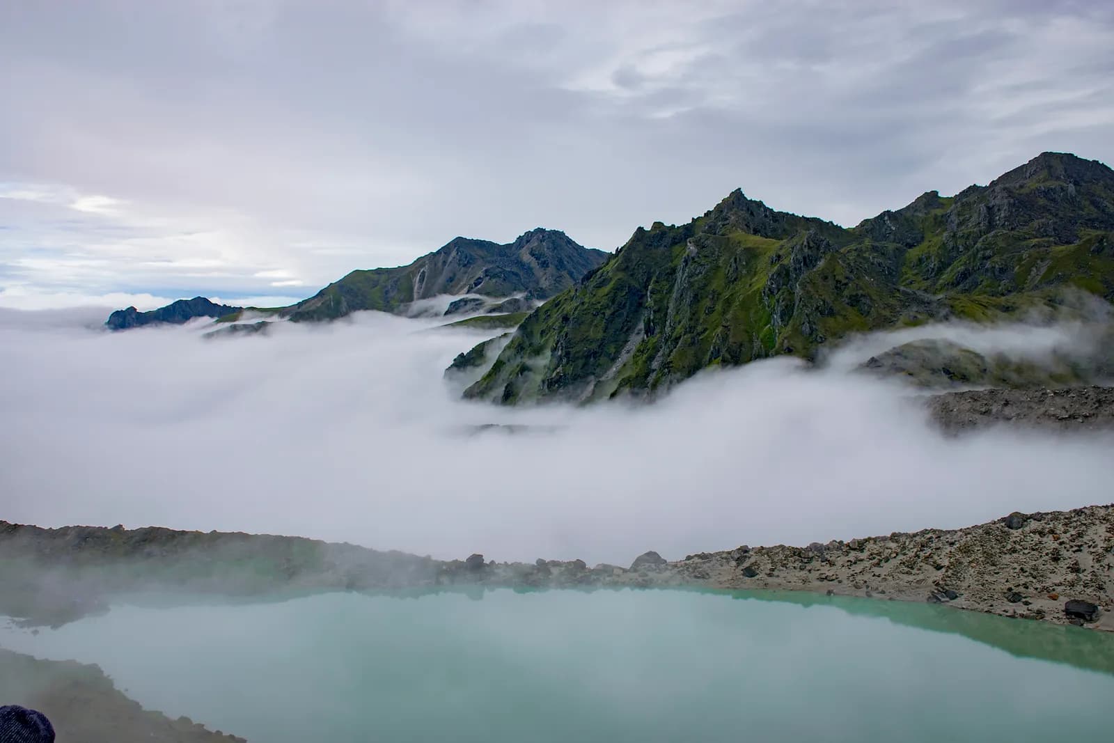
Dudh Kunda Trek
A six-day trek from Ringmu in Solu over Taksindu to Sano Beni and the sacred lake of Dudh Kunda at about 4,560 m below Numbur Himal, with a road start and finish.
- Hari6
- Altitud maksimum4,561 m
- Jarak37.7 km
- Pendakian2,439 m
- KesukaranSukar
- Bulan terbaikMar–May, Sep–Nov
- Permit3
Foto: Chandra Chakradhar · CC BY-SA 4.0
Dipaparkan dalam bahasa Inggeris — belum diterjemahkan.
Itinerari ini ialah draf dan belum disahkan. Sentiasa sahkan setiap peringkat dengan pemandu anda.
Written by FindTrekkingPartner teamDisemak oleh FindTrekkingPartner teamCara kami menyemakFindTrekkingPartner
Dudh Kunda Trek ialah trek 6 hari di wilayah Solu di Nepal yang mendaki sehingga 4,561 m. Pendaki asing boleh mencari rakan untuknya di FindTrekkingPartner dengan menyiarkan trip beserta tarikh, bajet dan rentak mereka. Padanan kekal peribadi sehingga kedua-dua pendaki bersetuju, dan perkhidmatan ini percuma. Pada kadar pertengahan, seorang pemandu berlesen berharga kira-kira USD 56 seorang untuk 6 hari apabila empat pendaki berkongsi, berbanding USD 224 untuk seorang pendaki bersendirian. Musim terbaik ialah Mar–May, Sep–Nov. Pemandu berlesen diperlukan dalam praktiknya di sini: peraturan Lembaga Pelancongan Nepal April 2023 dilaporkan oleh pengendali 2026 dikuatkuasakan di pusat pemeriksaan di taman negara dan kawasan pemuliharaan, dengan Langtang paling ketat dan Annapurna turut memeriksa (disemak 19 Oktober 2026). Upah pemandu melalui agensi berdaftar dan sahkan dengan mereka. Disahkan kali terakhir: 19 Oktober 2026. Sumber: Lembaga Pelancongan Nepal, DNPWC, Jabatan Imigresen.
Sumber:Department of Immigration, NepalNepal Tourism BoardDepartment of National Parks and Wildlife Conservation
Cari rakan untuk Dudh Kunda Trek
- Cari rakan untuk Dudh Kunda TrekBelum ada trip terbuka
- Cari rakan untuk Pikey Peak TrekBelum ada trip terbuka
Gambaran keseluruhan
Bermula dari Kathmandu6 hari · maks 4,561 m
Musim terbaik: Mar–May, Sep–Nov · Permit: No restricted-area permit, Outside Sagarmatha National Park, Ask your agency about any local trek card
The Dudh Kunda trek is a six-day walk from the village of Ringmu, above Salleri in Solukhumbu, to a high glacial lake at about 4,560 m under Numbur Himal that is sacred to Hindus and Buddhists. A jeep takes you from Kathmandu to Ringmu in about ten to eleven hours, the trail climbs through Taksindu to the inn at Sano Beni at about 4,000 m, and a day trip reaches the lake and returns. The walk back to Ringmu and a drive to Kathmandu finish the trip. It covers about 38 km with 2,440 m of climbing, and it is harder than the distances suggest, because two nights are at about 4,000 m and the stage from Taksindu to Sano Beni climbs 1,300 m. It needs no flight and no restricted-area permit, and warm clothing and a good sleeping bag matter more than technical gear.
The plan follows the Kathmandu Post's account of its Dudh Kunda walk, which uses the same stops, and an operator's day-by-day notes that route through Taksindu and Sano Beni; Alpine Adventure Club sells a longer cultural trail through Taksindu and Nunthala. Lodging is thin at Sano Beni, and the Post's writer found only a roughly built house, so carry a good sleeping bag, check with your agency, and allow time to acclimatise. The best months are March to May and September to November, and pilgrims come in the August full-moon week.
Difficulty and fitness
The trek is hard for its length. Sano Beni and the lake are at about 4,000 m and 4,560 m, you sleep at 4,000 m on two nights, and the climb from Taksindu is about 1,300 m in one day. It suits fit trekkers who have spent time above 3,500 m before, and the rest day at Sano Beni is part of the acclimatisation, not a spare day.
Budget notes
The Kathmandu Post gives NPR 13,000 per person for its own trip. Our estimate on the costs section uses Nepal-wide lodge and meal ranges with a guide, a porter and road transport, and shows the jeep fare as a line to check. Allow for a good sleeping bag and for a guide who knows the Taksindu to Sano Beni ridge.
What to pack
A warm sleeping bag rated well below freezing, a down jacket, gloves, a hat, waterproofs, a headlamp and snacks. Do not rely on finding food or rooms at Sano Beni without confirming first.
Sorotan
- Dudh Kunda, a pilgrimage lake at about 4,560 m below Numbur Himal
- The Kamidanda viewpoint, with Everest and Kanchenjunga on a clear day
- Taksindu monastery and the Taksindu La kani gate
- Quiet trails, with almost no other trekkers outside August
- A pilgrim festival in the full-moon week of August
Peta laluan
Data laluan daripada OpenStreetMap, belum disemak oleh pasukan kami. Gunakan untuk perancangan, bukan navigasi.
Hari demi hari
A short walk of about 2.2 km and 250 m, one to two hours by our estimate, takes you from Ringmu to Taksindu, at about 2,925 m, along a marked path with views back to the valley. Taksindu has a Sherpa monastery below Taksindu La, a pass at about 3,070 m on OpenStreetMap, where a Buddhist gate stands. Visit the monastery and the pass in the afternoon. The easy day is deliberate: tomorrow is long and climbs a long way, so rest, drink water and sleep as well as you can.
A long day of about 12 km and 1,310 m of climbing, seven to eight hours by our estimate, leads from Taksindu to Sano Beni. The path is marked, with rhododendron forest below and open pasture above, and the operator notes mention the Kamu Dada hotel and Aakhey Pokhari lakes as stops. Sano Beni is at about 4,010 m on the elevation model, and the inn there is basic. The Post's writer found lodging a hardship, so confirm your arrangements first. You gain a great deal of altitude today, so go slowly and watch for headache.
A day out and back from Sano Beni to Dudh Kunda: about 10.5 km round trip, with 660 m of climbing and descent, six to seven hours in all. The Post's writer climbed for about three hours to reach the lake at 4,561 m under Numbur Himal, which is held sacred, and returned to Sano Beni the same day. The weather often turns, so start early and turn back if it does. Walk quietly, do not disturb offerings, and avoid swimming. The night at Sano Beni gives you a second night at about 4,000 m before you descend.
A downhill day of about 12.8 km, 1,410 m of descent, five to six hours by our estimate, takes you from Sano Beni back along the ridge to Taksindu and on to Ringmu. The air thickens and the forest returns as you descend, and your knees will feel the drop. Kamidanda, the viewpoint above Ringmu, shows Everest and Kanchenjunga on a clear day, according to the Post, and new homestays were being built there. The hotel at Ringmu feels luxurious after Sano Beni.
Drive from Ringmu to Kathmandu, about an hour to Salleri and ten hours onward, according to the Post and Nepal Traveller, who give eight to twelve hours depending on conditions. Leave early, because daylight matters on the mountain road. Bring snacks, and allow a spare day before an international flight, as landslides can close the road. If you are connecting to a flight, you may prefer to fly from Phaplu, but flights depend on weather.
Berapa kosnya
Anggaran kos keseluruhan seorang: rumah tumpangan dan makanan mengikut altitud, pengangkutan, permit, serta pemandu dan porter. Semakin ramai pendaki berkongsi pemandu dan porter, semakin kurang dibayar setiap orang. Setakat Oktober 2026.
| Gaya | 1 pendaki berkongsi | 2 pendaki berkongsi | 4 pendaki berkongsi |
|---|---|---|---|
| Bajet | USD 130–USD 210* | USD 130–USD 210* | USD 130–USD 210* |
| Sederhana | USD 390–USD 600* | USD 280–USD 440* | USD 240–USD 380* |
| Selesa | USD 440–USD 670* | USD 370–USD 560* | USD 330–USD 510* |
Kongsi pemandu, jimat wang
Pada kadar pertengahan, pendaki solo membayar kira-kira USD 390–USD 600; empat pendaki berkongsi satu pemandu dan dua porter membayar kira-kira USD 240–USD 380 seorang (37% lebih murah pada hujung atas julat).
Pecahan untuk 2 pendaki berkongsi
| Item | Bajet | Sederhana | Selesa |
|---|---|---|---|
| Rumah tumpangan dan makanan | USD 130–USD 210 | USD 170–USD 280 | USD 230–USD 350 |
| Pemandu | — | USD 70–USD 120 | USD 70–USD 120 |
| Porter | — | USD 30–USD 60 | USD 60–USD 110 |
Bajet menggunakan pengangkutan awam dan tiada porter; pertengahan berkongsi satu porter antara dua pendaki dan kenderaan persendirian; selesa memberi setiap pendaki seorang porter. Pemandu disertakan jika diperlukan atau gayanya pertengahan atau selesa.
Rumah tumpangan dan makanan setiap malam (bilik dan sepinggan dal bhat)
3 malam 2,500 to 3,800 m: bilik USD 4–USD 11, dal bhat USD 5–USD 11 · 2 malam Above 3,800 m: bilik USD 7–USD 19, dal bhat USD 8–USD 13
Tidak termasuk
Tiada harga diterbitkan ditemui untuk: Kathmandu to Ringmu by road (return). Jumlah bertanda * tidak termasuk perkara ini; tanya agensi anda. Lodging at Sano Beni is thin, so confirm rooms or carry tents. The Kathmandu Post gives NPR 13,000 per person for its own five-day trip.
Sumber kos
- PriceNepal: Nepal Travel Cost Guide 2026 (2026-05-14)
- Third Rock Adventures: Nepal trek budget planner (2026-05-09)
- Himalayan Partner: Guide and porter price in Nepal 2026 (2026-02-10)
- Shikhar Adventure: Annapurna Circuit trek cost (2026-02-03)
- Nepal Tourism Board: Trekking Permit (2026-10-18)
Anggaran daripada panduan pengendali, bukan sebut harga. Tip, insurans, peralatan dan hotel Kathmandu tidak termasuk; USD pada kadar pertukaran platform.
Foto
Soalan lazim
This plan takes six days from Kathmandu to Kathmandu, with three days of walking up and one day of walking down plus a lake day. The Kathmandu Post describes a five-day trip, and operator plans range from seven to sixteen days with Pikey, Junbesi and Nunthala added.
The Kathmandu Post gives 4,561 m, and our elevation model gives about 4,630 m, so we quote about 4,560 m. The inn at Sano Beni, where you sleep, is at about 4,000 m.
No. There is another Dudhkunda in the Gaurishankar area of Dolakha, which is a different lake. This route goes to the one in Solukhumbu, below Numbur Himal.
In the full-moon week of August, according to the Kathmandu Post, when locals and pilgrims gather at the lake. At other times you are unlikely to meet anyone there, but the weather is wet in August.
No restricted-area permit is needed. The route is outside Sagarmatha National Park, so its entry permit does not apply. Ask your agency whether the local municipality collects a fee.
Sumber
Di sepanjang denai
Penginapan, bantuan perubatan, air dan pemandangan pada setiap hari laluan.
1. Kathmandu → Ringmu
- Tribhuvan International Airport · Lapangan terbang & pengangkutan · 1,340 m
2. Ringmu → Taksindu
- Hotel Yak&Nak · Penginapan · 2,770 m
- Quite view · Penginapan · 2,835 m
- Taksindu Lodge · Penginapan · 2,945 m
- Takassindu Resort · Penginapan · 2,900 m
Show all 5 places
- Hotel Yak&Nak · Penginapan · 2,770 m
- Quite view · Penginapan · 2,835 m
- Hiltop Guest House · Penginapan · 3,070 m
- Taksindu Lodge · Penginapan · 2,945 m
- Takassindu Resort · Penginapan · 2,900 m
3. Taksindu → Sano Beni
- Mountain View Lodge · Penginapan · 2,908 m
- Panorama Guest House · Penginapan · 2,946 m
- Lodges · Penginapan · 2,962 m
- Taksindu La · Alam semula jadi · 3,071 m
4. Sano Beni
- Numbur Guest House · Penginapan · 4,022 m
- Dudhkunda · Alam semula jadi · 4,606 m
5. Sano Beni → Ringmu
- Viewpoint · Tempat tinjauan · 3,073 m
- Sherpa Fast Food Lodge · Penginapan · 2,848 m
6. Ringmu → Kathmandu
Belum ada apa-apa dipetakan untuk hari ini.Belum ada apa-apa dipetakan untuk hari ini.
Kali terakhir disahkan pada 19 Okt 2026Laporkan maklumat lapuk