

Leave Kathmandu early for the drive north to Syabrubesi, at about 1,500 m, on the Trisuli road past Trisuli Bazaar and the approach to Langtang. Operators give 6 to 9 hours depending on the vehicle and the state of the road; the bus is slower and cheaper than a jeep. The road is narrow and winding, with some landslide sections. Syabrubesi is the busy start of the Langtang and Tamang Heritage routes, so you will see other trekkers. Check in to a lodge, confirm your permit paperwork with the guide, pack a daypack and have an early night before the first walking day.
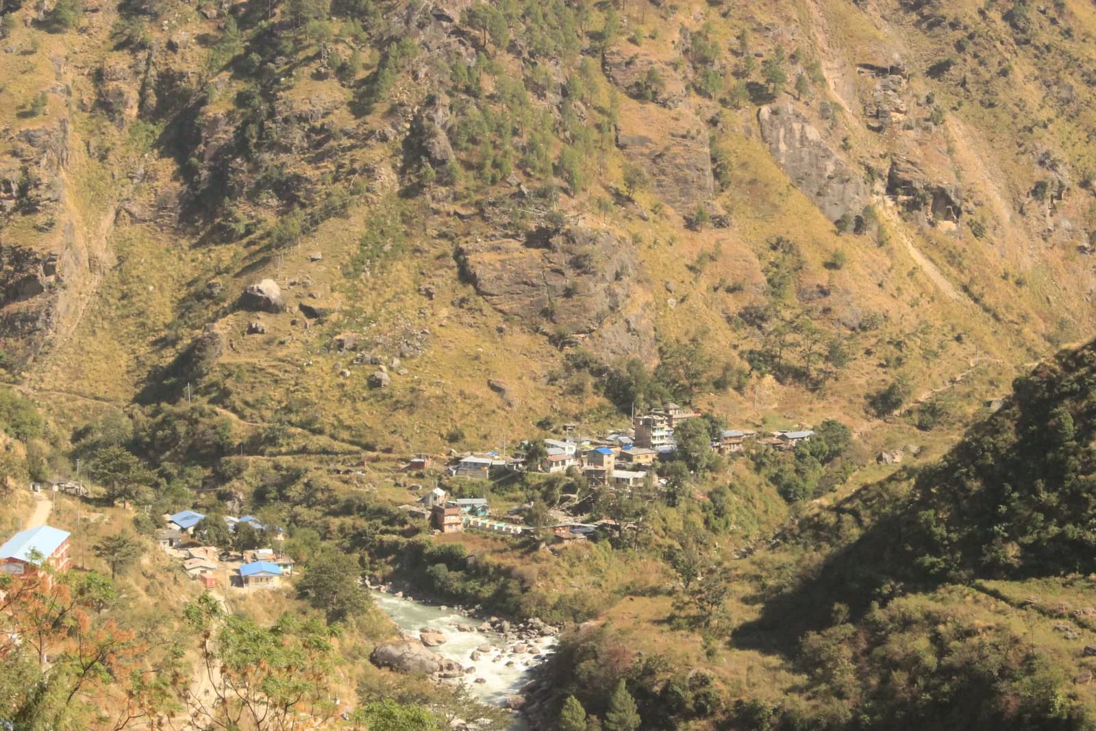
Ruby Valley and Ganesh Himal Trek
A 7-day village trek from Syabrubesi over Pangsang Pass to Tipling and Chalish, with a rest day around Chalish and a drive back through Dhading Besi.
- Hari7
- Altitud maksimum3,850 m
- Jarak43.7 km
- Pendakian3,638 m
- KesukaranSederhana
- Bulan terbaikMar–May, Oct–Nov
- Permit2
Rancang trip dengan itinerari iniCari rakan untuk Ruby Valley and Ganesh Himal TrekLihat pelepasan mengikut minggu
Foto: Rajivkilanashrestha · CC BY-SA 4.0
AmaranRuby Valley: the Syabrubesi start is not currently reliable
This route drives to Syabrubesi on day 1 and finishes at Chalish with a drive back through Dhading Besi. On 26 August 2026 a large rock-and-ice collapse from the north face of Langtang Lirung sent a debris flow down the Lhende Khola into the Bhote Koshi and Trishuli rivers, hitting Rasuwagadhi, Timure, Syabrubesi and Betrawati (ICIMOD). Many bridges and long stretches of the Pasang Lhamu Highway were damaged, and a large number of people died or are missing; reported figures differ by source.
Syabrubesi, the usual Langtang road-head, is reported destroyed or closed as a trekking gateway, with the bridge to it swept away; restoration depends on the Betrawati highway reopening. The Trishuli Bazaar-Betrawati-Dhunche road was reported still closed for repair as of 21 September. A light-vehicle track has reopened, and agencies projected the remaining gaps passable no earlier than mid-October; that is a projection, not an official date.
We found no source on the condition of the Ruby Valley trail itself or a reopening date. We found no official reopening notice. Check current road and trail conditions with Langtang National Park and your trekking agency before booking, and do not rely on this summary alone.
Status disemak 2026-10-19.
Sumber: ICIMOD: Kyirong-Rasuwa flood, 26 August 2026 · Nepal Pyramids: Langtang Valley trek update after the 2026 flooding · Republica: locals reopen flood-damaged Langtang trekking route (16 Oct)
Dipaparkan dalam bahasa Inggeris — belum diterjemahkan.
Itinerari ini ialah draf dan belum disahkan. Sentiasa sahkan setiap peringkat dengan pemandu anda.
Written by FindTrekkingPartner teamDisemak oleh FindTrekkingPartner teamCara kami menyemakFindTrekkingPartner
Ruby Valley and Ganesh Himal Trek ialah trek 7 hari di wilayah Ganesh Himal di Nepal yang mendaki sehingga 3,850 m. Pendaki asing boleh mencari rakan untuknya di FindTrekkingPartner dengan menyiarkan trip beserta tarikh, bajet dan rentak mereka. Padanan kekal peribadi sehingga kedua-dua pendaki bersetuju, dan perkhidmatan ini percuma. Pada kadar pertengahan, seorang pemandu berlesen berharga kira-kira USD 65 seorang untuk 7 hari apabila empat pendaki berkongsi, berbanding USD 261 untuk seorang pendaki bersendirian. Musim terbaik ialah Mar–May, Oct–Nov. Pemandu berlesen diperlukan dalam praktiknya di sini: peraturan Lembaga Pelancongan Nepal April 2023 dilaporkan oleh pengendali 2026 dikuatkuasakan di pusat pemeriksaan di taman negara dan kawasan pemuliharaan, dengan Langtang paling ketat dan Annapurna turut memeriksa (disemak 19 Oktober 2026). Upah pemandu melalui agensi berdaftar dan sahkan dengan mereka. Disahkan kali terakhir: 19 Oktober 2026. Sumber: Lembaga Pelancongan Nepal, DNPWC, Jabatan Imigresen.
Sumber:Department of Immigration, NepalNepal Tourism BoardDepartment of National Parks and Wildlife Conservation
Cari rakan untuk Ruby Valley and Ganesh Himal Trek
- Cari rakan untuk Ruby Valley and Ganesh Himal TrekBelum ada trip terbuka
Gambaran keseluruhan
Bermula dari KathmanduLaluan gunung: Pangsang Pass7 hari · maks 3,850 m
Musim terbaik: Mar–May, Oct–Nov · Permit: Langtang National Park entry permit, TIMS card where required
The Ruby Valley trek is a seven-day walk through the villages and forests on the south-west side of Ganesh Himal. It drives from Kathmandu to Syabrubesi, the Langtang trailhead, walks over Bahun Danda to the Tamang village of Gatlang, climbs to the forest camp at Somdang (about 3,270 m), crosses Pangsang Pass at about 3,850 m and descends to Tipling, then walks through the Tamang village of Sertung to Chalish, with a rest day around Chalish for Sertung and the Tatopani hot spring before a drive back to Kathmandu via Dhading Besi. The walking adds up to about 44 km on our mapped route with roughly 3,600 m of climbing, following the stages of the Nepal Alternative Treks, Himalaya Trip and Peregrine itineraries in the sources. It is a moderate trek, needs the Langtang National Park permit and no restricted-area permit, and runs best from late September to early December and in spring.
What the trek is like
The first day on foot climbs from the Bhote Koshi valley through forest to Bahun Danda and on to Gatlang, a village of dark stone houses at about 2,300 m. The next two days go up into pine and rhododendron forest to Somdang and over Pangsang Pass, where on clear days Ganesh Himal fills the northern horizon. The final descent leads through millet and maize terraces to Tipling and Chalish, villages where local families run homestays.
Permits and rules
The Langtang National Park entry permit is NPR 3,000 for foreigners (Nepal Tourism Board). A TIMS card is listed by some operators. The trek is not in a restricted area, so there is no minimum group size, but trails above Somdang are quiet, so most people go with a guide.
Best season
Mid-September to mid-December and March to May. Monsoon trails are slippery and leech-prone.
Altitude
The highest overnight is Somdang at about 3,270 m and the pass is about 3,850 m, so most people feel the height only as a little breathlessness. Walk slowly and drink well.
Getting there and away
Kathmandu to Syabrubesi is 6 to 9 hours by road, and Chalish to Kathmandu about 8 hours via Dhading Besi. Plan one spare day if road works or landslides are reported.
Lodges, food and costs
Homestays and simple guesthouses serve dal bhat. See the permit fees and sample costs in the costs section.
Extensions
Operators extend the trek with an acclimatisation day at Somdang, a walk on to Jharlang and Darkha, or a longer circuit through Hindung to Ganesh Himal Base Camp, which has no lodges.
Sorotan
- Gatlang, a Tamang village of stone houses and pilgrim lake
- Somdang, a forest camp at about 3,270 m below Ganesh Himal
- Pangsang Pass at about 3,850 m, with views of the Ganesh Himal range
- Tipling and Chalish, farming villages with homestays and the Tatopani hot spring nearby
- A moderate trek with no restricted-area permit
Peta laluan
Data laluan daripada OpenStreetMap, belum disemak oleh pasukan kami. Gunakan untuk perancangan, bukan navigasi.
Hari demi hari
Anda tidur 834 m lebih tinggi daripada malam sebelumnya, melebihi garis panduan biasa 500 m. Berjalan perlahan, minum banyak air dan perhatikan sakit kepala atau loya.
Cross to the west bank of the Bhote Koshi and climb through forest and farmland over Bahun Danda to Gatlang, at about 2,300 m. Operators allow 4 to 6 hours for the 11 km, and the gain is about 1,060 m. Gatlang is a Tamang village of stone houses, wooden balconies and prayer flags, with a pilgrim lake nearby. Walk through the lanes in the afternoon, and be respectful when entering temples or taking photos of people. Homestay families cook dal bhat and local food. The altitude is modest, but drink a lot and climb slowly.
Anda tidur 934 m lebih tinggi daripada malam sebelumnya, melebihi garis panduan biasa 500 m. Berjalan perlahan, minum banyak air dan perhatikan sakit kepala atau loya.
A long day of 6 to 7 hours takes you from Gatlang to Somdang, at about 3,270 m, climbing about 1,500 m over 12.6 km. The trail goes through dense pine and rhododendron forest, passing Khurpu Bhanjyang, a saddle of about 3,700 m on the map, before the final stretch to Somdang. The hamlet has a few guesthouses on a clearing with views down the valley. It is the highest night of the trek, so go slowly, eat well and wrap up in the evening, when the air turns cold quickly.
The hardest day: leave early and climb above the tree line to Pangsang Pass, at about 3,850 m, where the views take in the Ganesh Himal range on a clear morning. Then descend steeply through forest to Tipling, at about 2,000 m, a drop of about 1,800 m from the pass over 15 km on our mapped route. Operators allow 7 to 8 hours in total, and some call it 8 to 10, so start at first light and carry lunch. Poles are a great help on the knee-jarring descent. Tipling's homestays give a welcome rest at the end.
Walk down from Tipling through millet and maize terraces to Sertung, a Tamang village, and on to Chalish Gaon at about 1,675 m. Operators give 3 to 5 hours for the day, depending on how long you spend among the Sertung houses. Our map follows the footpath through Sertung: 4.7 km with about 360 m of climbing and 690 m of descent, so the day is short on distance but has a lot of up and down. One operator counts 12 km for the same day because it also visits upper villages that OpenStreetMap does not map. Stop in Sertung for tea, then continue to Chalish, home to Gurung, Ghale and Kami families, where the lower altitude and warmer evenings make a pleasant place to rest.
A rest day around Chalish with an optional walk of about 4 to 5 hours: operators suggest a round trip to Sertung, a viewpoint, and the Tatopani hot spring, where you can soak tired legs. The route is gentle and mostly on village paths, and you can shorten it or skip it. Ask your host about a cultural evening if you want music and dance, usually arranged on request. This is also the sensible day to wash clothes, back up photos and repack for the road, because the last day is a long drive.
Drive from Chalish via Dhading Besi to Kathmandu, a journey of about 8 hours on the Dhading and Prithvi roads. Operators quote between 7 and 9 hours with a mix of private jeep and bus; the stretch to Dhading Besi is rough and slow, and the rest is on tarmac. Leave early, take snacks and water, and keep a spare day in your plans if the monsoon or road works are reported. Back in Kathmandu, hand back any rented gear and settle up with the guide and drivers.
Aklimatisasi
Altitud tidur malam demi malam. Bar merah naik lebih 500 m daripada malam sebelumnya; hari rehat ditandakan.
- Altitud tidur
- Pertambahan melebihi 500 m
- Hari rehat
Berapa kosnya
Anggaran kos keseluruhan seorang: rumah tumpangan dan makanan mengikut altitud, pengangkutan, permit, serta pemandu dan porter. Semakin ramai pendaki berkongsi pemandu dan porter, semakin kurang dibayar setiap orang. Setakat Oktober 2026.
| Gaya | 1 pendaki berkongsi | 2 pendaki berkongsi | 4 pendaki berkongsi |
|---|---|---|---|
| Bajet | USD 340–USD 430 | USD 240–USD 330 | USD 190–USD 280 |
| Sederhana | USD 770–USD 1,150 | USD 470–USD 700 | USD 340–USD 510 |
| Selesa | USD 820–USD 1,200 | USD 560–USD 830 | USD 430–USD 650 |
Kongsi pemandu, jimat wang
Pada kadar pertengahan, pendaki solo membayar kira-kira USD 770–USD 1,150; empat pendaki berkongsi satu pemandu dan dua porter membayar kira-kira USD 340–USD 510 seorang (55% lebih murah pada hujung atas julat).
Pecahan untuk 2 pendaki berkongsi
| Item | Bajet | Sederhana | Selesa |
|---|---|---|---|
| Rumah tumpangan dan makanan | USD 100–USD 170 | USD 130–USD 230 | USD 190–USD 300 |
| Pengangkutan | USD 100–USD 130 | USD 150–USD 220 | USD 150–USD 220 |
| Permit | USD 30–USD 40 | USD 30–USD 40 | USD 30–USD 40 |
| Pemandu | — | USD 100–USD 160 | USD 100–USD 160 |
| Porter | — | USD 30–USD 70 | USD 70–USD 130 |
Bajet menggunakan pengangkutan awam dan tiada porter; pertengahan berkongsi satu porter antara dua pendaki dan kenderaan persendirian; selesa memberi setiap pendaki seorang porter. Pemandu disertakan jika diperlukan atau gayanya pertengahan atau selesa.
Rumah tumpangan dan makanan setiap malam (bilik dan sepinggan dal bhat)
5 malam Below 2,500 m: bilik USD 2–USD 9, dal bhat USD 4–USD 7 · 1 malam 2,500 to 3,800 m: bilik USD 4–USD 11, dal bhat USD 5–USD 11
Yuran permit (sumber rasmi)
Sumber kos
- PriceNepal: Nepal Travel Cost Guide 2026 (2026-05-14)
- Third Rock Adventures: Nepal trek budget planner (2026-05-09)
- Himalayan Partner: Guide and porter price in Nepal 2026 (2026-02-10)
- Shikhar Adventure: Annapurna Circuit trek cost (2026-02-03)
- Nepal Tourism Board: Trekking Permit (2026-10-18)
- Mount Mania: Ruby Valley trek (2026-10-18)
Anggaran daripada panduan pengendali, bukan sebut harga. Tip, insurans, peralatan dan hotel Kathmandu tidak termasuk; USD pada kadar pertukaran platform.
Foto
Soalan lazim
It is a moderate trek of 7 days with one hard day, Somdang to Tipling, of 7 to 8 hours over Pangsang Pass. The highest night is about 3,270 m.
Operators list the Langtang National Park entry permit, which the Nepal Tourism Board puts at NPR 3,000 for foreigners. It is not a restricted area.
It suits fit first-timers who are used to 5 to 8 hour days. The altitude is modest, but lodging is basic homestays and the trails are quieter than the main circuits.
By road: operators allow about 8 hours from Chalish via Dhading Besi to Kathmandu, by private jeep or a mix of jeep and bus.
Operators offer an 11 to 12 day circuit that adds Hindung and the base camp, but there are no hotels at the base camp, so it needs camping support.
Sumber
- Ruby Valley Trek 7 days (Nepal Alternative Treks)
- Ruby Valley Trek (Himalaya Trip)
- Ruby Valley Trek (Peregrine Treks)
- Ruby Valley Trek 10 days (Mount Mania)
- Ganesh Himal (Wikipedia)
- Nepal Tourism Board: Park Entry Fees
- Ruby Valley Home Stay Trek (Himalayan Local Guide)
- Sirtung (Sertung), Dhading (Wikipedia)
Di sepanjang denai
Penginapan, bantuan perubatan, air dan pemandangan pada setiap hari laluan.
1. Kathmandu → Syabrubesi
- Tribhuvan International Airport · Lapangan terbang & pengangkutan · 1,340 m
2. Syabrubesi → Gatlang
- Temple · Tempat tinjauan · 2,323 m
- Ronga Bhaniyan · Alam semula jadi · 2,240 m
- Tamang Home · Penginapan · 2,358 m
- Pador Peak Guest House · Penginapan · 2,343 m
- Stone Woodland Guest House · Penginapan · 2,302 m
- Langtang View Guest House · Penginapan · 2,268 m
Show all 10 places
- Temple · Tempat tinjauan · 2,323 m
- Bagung view point Hotel & Lodge · Penginapan · 2,243 m
- Goljung Danda Chhamgang Hotel & Lodge · Penginapan · 2,243 m
- Ronga Bhaniyan · Alam semula jadi · 2,240 m
- Unique Lunch Place with Home Stay · Penginapan · 2,293 m
- Gyalbo Guest House · Penginapan · 2,314 m
- Tamang Home · Penginapan · 2,358 m
- Pador Peak Guest House · Penginapan · 2,343 m
- Stone Woodland Guest House · Penginapan · 2,302 m
- Langtang View Guest House · Penginapan · 2,268 m
3. Gatlang → Somdang
- Langatang View Guest House · Penginapan · 2,267 m
- Gatlang guest house · Penginapan · 2,323 m
- Royal Gatlang Guest House · Penginapan · 2,334 m
- Parvati Kund · Alam semula jadi · 2,600 m
- Somdang Valley Lodge · Penginapan · 3,276 m
Show all 8 places
- Langatang View Guest House · Penginapan · 2,267 m
- Gatlang guest house · Penginapan · 2,323 m
- Royal Gatlang Guest House · Penginapan · 2,334 m
- Hotel Zeppa · Penginapan · 2,336 m
- Parvati Kund · Alam semula jadi · 2,600 m
- Parbati Kunda Guest House · Penginapan · 2,655 m
- Ruby Valley Guest House & Homestay · Penginapan · 2,673 m
- Somdang Valley Lodge · Penginapan · 3,276 m
4. Somdang → Tipling
- Trail to Guesthouses · Tempat tinjauan · 2,244 m
- Ashok Ruby Valley Homestay · Penginapan · 2,224 m
- Tipling Homestay · Penginapan · 2,216 m
- Ruby Valley Tipling Hotel · Penginapan · 2,238 m
- Edwin Tamang Homestay · Penginapan · 2,050 m
5. Tipling → Chalish
- Ganesh Himal Hotel · Penginapan · 1,936 m
- Healthpost · Perubatan · 1,990 m
6. Chalish
Belum ada apa-apa dipetakan untuk hari ini.Belum ada apa-apa dipetakan untuk hari ini.7. Chalish → Kathmandu
Belum ada apa-apa dipetakan untuk hari ini.Belum ada apa-apa dipetakan untuk hari ini.
Kali terakhir disahkan pada 19 Okt 2026Laporkan maklumat lapuk