

Fly from Kathmandu to Dhangadhi, a flight of about an hour according to the operator itineraries we read, to the warm Terai plains at about 110 m. Transfer to a hotel, meet your guide and crew, and check permits, gear, tents, stoves and food, since the plateau has no shops. The next day is a long drive, so buy snacks and water, and have an early night. Flights can be delayed or cancelled, so do not schedule a connecting international flight on the same day, and keep your passport handy for the airport and the park permits.
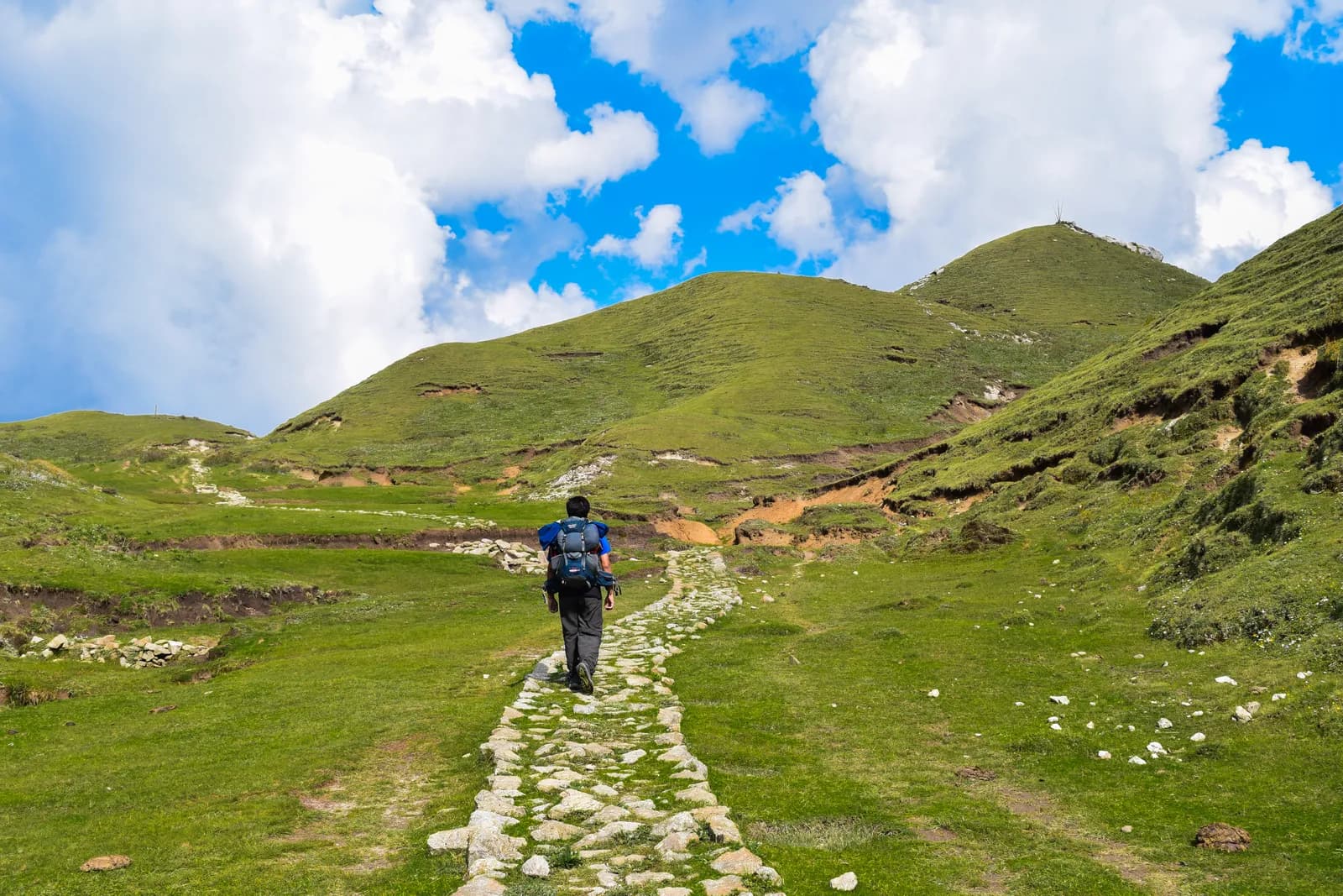
Khaptad National Park Trek
A ten-day trek from Silgadhi in Doti up to the Khaptad plateau at about 3,000 m, with the ashram of Khaptad Baba, the sacred lake of Khaptad Daha and flights to and from Dhangadhi.
- 일수10
- 최고 고도3,276 m
- 거리72.5 km
- 상승 고도3,301 m
- 난이도보통
- 최적 시기Mar–May, Oct–Dec
- 퍼밋3
사진: Anil Bhatta · CC BY-SA 4.0
영어로 표시됨 — 아직 번역되지 않았습니다.
이 일정은 초안이며 아직 확인되지 않았습니다. 구간은 항상 가이드와 확인하세요.
Written by FindTrekkingPartner team검토: FindTrekkingPartner team검토 방식FindTrekkingPartner
Khaptad National Park Trek은(는) 네팔 Khaptad 지역의 10일 일정 트레킹으로, 최고 3,276 m까지 오릅니다. 외국인 트레커는 FindTrekkingPartner에 날짜, 예산, 페이스를 적어 트립을 올리면 이 트레킹의 파트너를 찾을 수 있습니다. 매칭은 두 트레커가 모두 동의하기 전까지 비공개로 유지되며, 서비스는 무료입니다. 중간 요금 기준으로 공인 가이드 비용은 트레커 4명이 함께할 때 10일 동안 1인당 약 USD 93, 혼자일 때는 USD 373입니다. 최적의 시즌은 Mar–May, Oct–Dec입니다. 이곳에서는 사실상 공인 가이드가 필요합니다. 2026년 운영업체들의 보고에 따르면 2023년 4월 네팔관광청 규정이 국립공원과 보전지역 검문소에서 시행되고 있으며, 랑탕이 가장 엄격하고 안나푸르나도 확인합니다(2026년 10월 19일 확인). 등록된 여행사를 통해 가이드를 고용하고 여행사에 확인하세요. 이 루트의 모집 중인 트립은 출발 월, 그룹 규모, 남은 자리와 함께 아래에 나와 있습니다. 최종 확인일: 2026년 10월 19일. 출처: 네팔관광청, DNPWC, 출입국관리국.
출처:Department of Immigration, NepalNepal Tourism BoardDepartment of National Parks and Wildlife Conservation
Khaptad National Park Trek 파트너 찾기
- Khaptad National Park Trek 파트너 찾기아직 모집 중인 트립이 없습니다
개요
출발지: Kathmandu10일 · 최고 3,276 m
최적 시즌: Mar–May, Oct–Dec · 퍼밋: Khaptad National Park entry permit (NPR 3,000 for foreigners), TIMS card where your agency requires it, No restricted-area permit
The Khaptad National Park trek is a ten-day journey from Kathmandu to the high meadow plateau of Khaptad in far-western Nepal. It flies to Dhangadhi, drives about nine hours to Silgadhi, then walks up the valley road to Jhigrana, climbs a marked path to Bichpani Camp, and crosses the plateau at about 3,000 m to Khaptad, where a rest day visits the lake of Khaptad Daha and the ashram of Khaptad Baba. The return retraces the route and finishes with a drive to Dhangadhi and a flight to Kathmandu. The walking is about 72 km with 3,330 m of climbing, spread over six days. The park entry fee for foreigners is NPR 3,000. Khaptad is not a restricted area, the best months are March to May and October to December, and it is a quiet trek that few foreigners walk.
The plan follows a nine-day operator itinerary and an eleven-day one, which agree on Silgadhi, Bichpani and Khaptad, and the Great Himalaya Trail description, which says that the most popular option is to return the same way. The first walking day is long and mostly on a motor road, and the plateau is level and quiet. Lodging is sparse: expect tents at Bichpani and on the plateau, and homestays or lodges in the villages. The best months are March to May and October to December.
What the trek is like
The trek changes character on the way: a valley road with villages and terraces, a steep forest path to Bichpani, then open grass, scattered trees and a few huts on the plateau. Weather can be wet and cold even in spring, and the plateau offers no shelter in a storm.
Permits and rules
The park entry fee is NPR 3,000 for foreigners and NPR 1,500 for SAARC nationals, per the Nepal Tourism Board. Khaptad is not a restricted area. The Bajhang restricted-area entry applies only to Saipal Rural Municipality.
Best season
March to May and October to December. The Great Himalaya Trail page says winter snow closes the park from late December to the end of February.
Getting there and away
Kathmandu to Dhangadhi is about an hour by air, and the road to Silgadhi takes eight to nine hours. The return mirrors it.
Difficulty and fitness
The trek is moderate in altitude and demanding in logistics. The plateau is at about 3,000 m, so altitude is mild, but the first walking day is about 17.7 km and 1,250 m, the climb to Bichpani Camp is steep, and the journey includes two long travel days. You need to be comfortable camping for several nights and walking six to eight hours in the first days.
Budget notes
The costs section uses Nepal-wide lodge and meal ranges for the town nights, adds the park fee of NPR 3,000 and a guide and porters, shows the flight and the road transfer as lines to check, and states that tents, crew and food for the plateau are quoted by the agency.
What to pack
A warm sleeping bag, a down jacket, waterproofs, poles, a head torch, water treatment, a first-aid kit and a printed copy of your permits. Weather on the open plateau can change quickly.
하이라이트
- A high meadow plateau at about 3,000 m with oak, pine and rhododendron forest
- The ashram of Khaptad Baba and the Tribeni shrine
- Khaptad Daha, a pilgrimage lake
- Sahashra Linga, about 3,276 m, the park's highest point
- A remote far-west trek that few foreigners visit
루트 지도
OpenStreetMap의 루트 데이터이며 아직 저희 팀이 확인하지 않았습니다. 계획용으로만 사용하고 길 안내용으로는 사용하지 마세요.
일별 일정
전날 밤보다 1,221 m 높은 곳에서 잡니다. 일반 권장 기준인 500 m를 넘습니다. 천천히 움직이고, 물을 충분히 마시고, 두통이나 메스꺼움을 살피세요.
A long drive of about eight to nine hours from Dhangadhi to Silgadhi, the headquarters of Doti District, at about 1,330 m, along a road that climbs from the plains into the western hills. The road is rough in places and can be blocked by landslides in the monsoon. Operators give eight to nine hours, and the Great Himalaya Trail page says about six hours from Nepalgunj. Stay in a lodge at Silgadhi, check your gear and plan the next day with your guide. The walk starts early.
전날 밤보다 920 m 높은 곳에서 잡니다. 일반 권장 기준인 500 m를 넘습니다. 천천히 움직이고, 물을 충분히 마시고, 두통이나 메스꺼움을 살피세요.
The first walking day is long. From Silgadhi, walk about 17.7 km and 1,250 m up the valley road to Jhigrana, at about 2,250 m, where the park entrance is. On our map the road is the only route, and the walk takes seven to eight hours by our estimate. Some groups hire a vehicle for part of it. The valley has terraces, small villages and a view of the hills opening up as you climb. Stay in a lodge or homestay at Jhigrana, and register at the park entrance.
A shorter day of about 6.2 km, with 920 m of climbing, four to five hours, takes you from Jhigrana to Bichpani Camp, on a marked path through forest, past rhododendron and oak. Bichpani Camp is at about 3,100 m by the elevation model, a meadow with a few huts and tents, and the first place where you sleep above 3,000 m. Operators give about 2,743 m, which is far from the model, so we do not state a height. Rest in the afternoon, drink plenty of water and wrap up warm, since the nights are cold.
From Bichpani Camp, walk about 9.5 km across open plateau to Khaptad, in three to four hours, which is nearly level at about 3,000 m on grass and forest tracks. The Saipal range appears on the horizon in clear weather. Khaptad, where a hotel and the park buildings stand, is the base for the next day. Your tent or lodge is here for two nights. Rest, wander the meadows and watch for birds. You are well above 3,000 m, so a short walk in the evening helps with sleep.
A day to explore. A walk of about 5.7 km round trip, three to four hours, takes you to Khaptad Daha, the lake beside the trail to Kolti where local people believe Shiva bathed. The ashram of Khaptad Baba, who meditated here for about fifty years and died in 1996, is near the park headquarters, and Tribeni, a confluence of streams with a Shiva temple, is also on the plateau. Strong walkers can add Sahashra Linga, about 3,276 m and a five-hour round trip, if the weather is good. Dress modestly at the shrines.
A long downhill day of about 15.7 km and 1,210 m of descent, six to seven hours by our estimate, takes you from Khaptad back over Bichpani Camp to Jhigrana. The way is the same as the way up: grass and forest tracks across the plateau, then the steep marked path through forest. Because it is downhill, the day is faster than the climb, but it is hard on the knees, so use poles. You sleep at Jhigrana again, where the lodge is familiar.
Walk about 17.7 km down the valley road from Jhigrana to Silgadhi, with 1,240 m of descent, six to seven hours by our estimate. You can ask a vehicle to meet you part of the way, as the road reaches the Jhigrana area. At Silgadhi you reach roads, shops and a hot meal. The last night in the hills is a good time to thank your crew, and to repack for the long drive tomorrow. Silgadhi sits at about 1,330 m.
Drive from Silgadhi to Dhangadhi, eight to nine hours. The road drops from the hills to the plains and is slow in places, so leave early and carry snacks, water and a warm layer for the first cool hours. Spend the night in a hotel at Dhangadhi near the airport, ready for the morning flight, and settle accounts with your crew and guide this evening. If rain has closed the road, tell your agency early so it can rebook the flight for the next available day.
Fly from Dhangadhi to Kathmandu, about an hour, and arrive in the city by midday if the weather is clear. Flights in the far west are the most likely to be cancelled, so keep a spare day in your plan before an international flight, and ask your agency about the next available seat if the morning flight does not operate. Transfer to your hotel, wash, and rest, then spend the afternoon in the city. Ten days of camping and simple food leave most people glad of a proper bed.
고소 적응
밤마다의 숙박 고도입니다. 빨간 막대는 전날 밤보다 500 m 넘게 올라가는 날이며, 휴식일은 표시됩니다.
- 숙박 고도
- 500 m 초과 상승
- 휴식일
비용
1인당 예상 총비용: 고도별 롯지와 식사, 교통, 퍼밋, 가이드와 포터. 가이드와 포터를 나누는 트레커가 많을수록 1인당 부담이 줄어듭니다. 2026년 10월 기준.
| 스타일 | 트레커 1명 분담 | 트레커 2명 분담 | 트레커 4명 분담 |
|---|---|---|---|
| 저예산 | US$190–US$300* | US$190–US$300* | US$190–US$300* |
| 중간 | US$590–US$910* | US$420–US$650* | US$360–US$560* |
| 편안함 | US$670–US$1,050* | US$550–US$840* | US$490–US$750* |
가이드를 나누고 비용 절약
중간형 기준으로 혼자 트레킹하면 약 US$590–US$910, 트레커 4명이 가이드 1명과 포터 2명을 나누면 1인당 약 US$360–US$560입니다 (범위 상단 기준 38% 절감).
2명 분담 시 내역
| 항목 | 저예산 | 중간 | 편안함 |
|---|---|---|---|
| 롯지 및 식사 | US$150–US$260 | US$220–US$360 | US$300–US$470 |
| 퍼밋 | US$30–US$40 | US$30–US$40 | US$30–US$40 |
| 가이드 | — | US$110–US$180 | US$110–US$180 |
| 포터 | — | US$40–US$80 | US$90–US$160 |
예산형은 대중교통을 이용하고 포터가 없습니다. 중간형은 트레커 두 명이 포터 한 명을 나누고 전용 차량을 씁니다. 편안형은 트레커마다 포터가 한 명씩 있습니다. 가이드는 필수이거나 스타일이 중간형 또는 편안형인 경우에 포함됩니다.
1박 롯지 및 식사 (객실과 달밧 식사)
6박 Below 2,500 m: 객실 US$2–US$9, 달밧 US$4–US$7 · 3박 2,500 to 3,800 m: 객실 US$4–US$11, 달밧 US$5–US$11
퍼밋 요금 (공식 출처)
포함되지 않음
공개된 가격을 찾지 못한 항목: Kathmandu to Dhangadhi flight (return); Dhangadhi to Silgadhi by road (return). *로 표시된 총액에는 이 항목이 빠져 있으니 에이전시에 문의하세요. 캠핑 트레킹입니다. 스태프, 텐트, 식사는 에이전시가 견적을 냅니다. Tents, crew, kitchen and food on the plateau are quoted by the agency and are not in this estimate; the town nights use lodge rates.
비용 출처
- PriceNepal: Nepal Travel Cost Guide 2026 (2026-05-14)
- Third Rock Adventures: Nepal trek budget planner (2026-05-09)
- Himalayan Partner: Guide and porter price in Nepal 2026 (2026-02-10)
- Shikhar Adventure: Annapurna Circuit trek cost (2026-02-03)
- Nepal Tourism Board: Trekking Permit (2026-10-18)
운영사 가이드를 바탕으로 한 추정치이며 견적이 아닙니다. 팁, 보험, 장비, 카트만두 호텔은 포함되지 않으며 USD는 플랫폼 환율을 적용했습니다.
사진
자주 묻는 질문
This plan takes ten days from Kathmandu to Kathmandu: two days of flights and roads each way, six days of walking including a rest day on the plateau. Operators sell versions of seven to twelve days, and the Great Himalaya Trail notes that most people return the way they came.
NPR 3,000 per person per entry for foreigners and NPR 1,500 for SAARC nationals, according to the Nepal Tourism Board's park fee table. One operator page quotes NPR 1,500 for foreigners, which is the SAARC figure.
The plateau is at about 3,000 m on our elevation model. The park ranges from about 1,400 m to 3,300 m, and Sahashra Linga, at about 3,276 m, is its highest point, according to the Great Himalaya Trail page and an operator.
An ascetic who spent about fifty years meditating in the area and died in 1996, according to the Great Himalaya Trail page. The park was established in 1984 on his advice, per Wikipedia.
March to May and October to December. Winter snow closes the park from late December to the end of February, and monsoon rain can close roads for weeks.
출처
트레일 주변
루트의 매일마다 있는 숙소, 의료 지원, 식수, 볼거리입니다.
1. Kathmandu → Dhangadhi
- Tribhuvan International Airport · 공항 및 교통 · 1,340 m
2. Dhangadhi → Silgadhi
이 날에 지도에 표시된 항목이 아직 없습니다.이 날에 지도에 표시된 항목이 아직 없습니다.3. Silgadhi → Jhigrana
- Saileshoi guest houe · 숙소 · 1,275 m
- Baglekh Health Post · 의료 · 1,701 m
4. Jhigrana → Bichpani Camp
이 날에 지도에 표시된 항목이 아직 없습니다.이 날에 지도에 표시된 항목이 아직 없습니다.5. Bichpani Camp → Khaptad
- Khaptad Hotel · 숙소 · 3,052 m
6. Khaptad
이 날에 지도에 표시된 항목이 아직 없습니다.이 날에 지도에 표시된 항목이 아직 없습니다.7. Khaptad → Jhigrana
- Bichpani saud hotel · 숙소 · 3,109 m
8. Jhigrana → Silgadhi
- Jhigrana Hotel · 숙소 · 2,241 m
- Baglekh · 숙소 · 2,044 m
- Doti District Hospital · 의료 · 1,379 m
- Hotel Lord Buddha · 숙소 · 1,309 m
9. Silgadhi → Dhangadhi
이 날에 지도에 표시된 항목이 아직 없습니다.이 날에 지도에 표시된 항목이 아직 없습니다.10. Dhangadhi → Kathmandu
이 날에 지도에 표시된 항목이 아직 없습니다.이 날에 지도에 표시된 항목이 아직 없습니다.
2026. 10. 19. 최종 확인오래된 정보 신고