

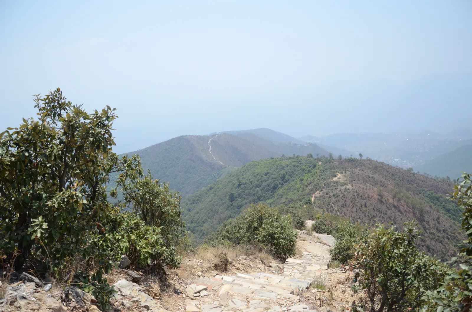
Drive from Kathmandu to Pharping and start walking early. The path climbs through pine forest on stone paving and steps, passes Hattiban Resort about half an hour above the road if you start at Pahiro, and then rises steadily for about three hours to the ridge, where the shrine of Champadevi stands in the open at about 2,285 m. On our map the round trip is 11.2 km with 750 m of climbing from Pharping. Rest at the top for the views of the Langtang and Ganesh Himal ranges, then descend by the same path, or drop steeply to the Champadevi Mai temple and walk about half an hour on the road to Khahare, where your car waits. Carry lunch and water.
Champadevi Day Hike
A one-day hike from Pharping through pine forest to the Champadevi hilltop shrine (about 2,285 m) and back, 11.2 km with 750 m of climbing and views of Langtang, Ganesh Himal and Gaurishankar.
- 日数1
- 最高標高2,285 m
- 距離11.2 km
- 累積上昇747 m
- 難易度普通
- ベストシーズンOct–Nov, Mar–May
写真:Pratap Baniya · CC BY-SA 4.0
英語で表示しています(未翻訳)。
この行程は下書きで、まだ確認されていません。各区間は必ずガイドに確認してください。
Written by FindTrekkingPartner team確認者: FindTrekkingPartner team確認方法についてFindTrekkingPartner
Champadevi Day Hikeは、ネパールのKathmandu Valley地域にある1日間のトレッキングで、標高2,285 mまで登ります。外国人トレッカーは、FindTrekkingPartnerに日程、予算、ペースを添えてトリップを投稿すれば、このトレッキングのパートナーを探せます。マッチングは両者が同意するまで非公開で、サービスは無料です。 中級クラスの料金では、ライセンスを持つガイドの費用は、トレッカー4人でシェアすると1日間で1人あたり約USD 9、1人だけの場合はUSD 37です。ベストシーズンはOct–Nov, Mar–Aprです。 このような一般ルートでは、ライセンスガイドの同行は義務付けられていません(2026年10月19日確認)。クンブ自治体はネパール観光局の2023年4月の規則から外れる決定をしており、日帰りハイキングにはガイドは不要ですが、それでもガイドの同行を強くおすすめします。旅行会社に確認してください。 このルートの募集中のトリップを以下に表示します。出発月、グループ人数、残り枠を確認できます。 最終確認日: 2026年10月19日。出典: ネパール観光局、DNPWC、入国管理局。
出典:Department of Immigration, NepalNepal Tourism BoardDepartment of National Parks and Wildlife Conservation
Champadevi Day Hikeのパートナーを探す
- Champadevi Day Hikeのパートナーを探す募集中のトリップはまだありません
- Shivapuri Peak Day Hikeのパートナーを探す募集中のトリップはまだありません
- Nagarkot to Changu Narayan Day Hikeのパートナーを探す募集中のトリップはまだありません
- Chisapani Nagarkot Trekのパートナーを探す募集中のトリップはまだありません
- Phulchowki Day Hikeのパートナーを探す募集中のトリップはまだありません
- Namo Buddha Day Hikeのパートナーを探す募集中のトリップはまだありません
概要
Pharpingから出発1日間 · 最高 2,285 m
ベストシーズン:Oct–Nov, Mar–May
The Champadevi hike is a one-day walk from Pharping, on the southern rim of the Kathmandu Valley, through pine forest to the open hilltop shrine of Champadevi at about 2,285 m, and back. On our map the round trip is about 11.2 km with 750 m of climbing, mostly on a stone-paved path and forest track. Operators put the climb from Hattiban Resort at about three hours and the whole climb from the road at three to three and a half hours; the descent takes one to two hours. Allow five to seven hours for the day, with a 45 minute drive each way from Kathmandu. On a clear morning the view runs from Langtang and Ganesh Himal to Manaslu and Gaurishankar. None of our sources lists a park permit for this hill. Bring water and lunch.
The plan follows two operator itineraries that agree on the Hattiban Resort halfway point and the open shrine at the top. Heights vary between 2,278 and 2,285 m in the sources and OpenStreetMap gives 2,241 m for the summit node, so we say about 2,285 m. Operators start at Pahiro or Hattiban to save time; our map starts lower, at Pharping, and is therefore longer.
What the hike is like
The path climbs steadily through pine forest on stone paving and steps, passes Hattiban Resort and continues to a ridge where the shrine of Champadevi stands in the open. From the ridge you see Chandragiri on one side and Phulchowki on the other, with the Bagmati river and Khokana below. An optional extension continues to Bhasmasur hill, which is higher than Champadevi. Pharping, a Newar village, is worth a stop before or after the walk.
Permits and rules
Neither operator lists a park permit or entrance fee for the hill. Monument fees at Pharping or Dakshinkali temples, if you visit them, are separate. Carry your litter out.
Best season
Operators say the hike can be done in every season and advise an early start for clear skies. Autumn (October to November) and spring (March to May) give the sharpest mountain views; in the monsoon the paving is wet and cloud hides the peaks.
Getting there and away
Drive from Kathmandu to Pharping or to Pahiro, about 45 minutes from Thamel, and finish at Khahare or Machhegaun, about 45 minutes back by road, depending on traffic. A taxi or an operator transfer is the simplest way; no fare is published in our sources, so agree it in advance.
Difficulty and fitness
The hike is gentle to moderate: 750 m of climbing, mostly on paved steps, over five to seven hours. Good shoes, two litres of water and a rain jacket are enough. Leave Pharping by 8 am so that you are on top before the haze builds.
Budget notes
There is no permit fee. Budget for a taxi to the trailhead and a return from Khahare or Pharping, plus lunch. The costs section shows the transfers as lines to check.
ハイライト
- Champadevi hilltop shrine at about 2,285 m with Himalayan views on clear days
- Stone-paved path and steps through pine forest
- Hattiban Resort halfway up as a rest stop
- Pharping, a Newar village with monasteries and the Dakshinkali temple nearby
- Chandragiri on one side and Phulchowki on the other from the ridge
ルートマップ
ルートデータはOpenStreetMapのもので、まだ当チームで確認していません。計画の参考にとどめ、ナビゲーションには使わないでください。
日ごとの行程
費用
1人あたりの総額の目安です。標高別のロッジと食事、交通費、許可証、ガイドとポーターが含まれます。ガイドとポーターを分け合うトレッカーが多いほど、1人あたりの負担は小さくなります。 2026年10月時点
| スタイル | 1人で分担 | 2人で分担 | 4人で分担 |
|---|---|---|---|
| 節約 | — | — | — |
| 標準 | $40–$80* | $20–$40* | $10–$30* |
| 快適 | $40–$80* | $30–$50* | $20–$40* |
ガイドを分け合って節約
中価格帯の場合、1人で歩くと約$40–$80です。4人で1人のガイドと2人のポーターを分け合うと、1人あたり約$10–$30になります(最大で66%安くなります)。
2人で分担する場合の内訳
| 項目 | 節約 | 標準 | 快適 |
|---|---|---|---|
| ガイド | — | $10–$30 | $10–$30 |
| ポーター | — | $0–$20 | $10–$30 |
予算重視は公共交通機関を使い、ポーターなしです。中価格帯は2人で1人のポーターを分け合い、車は貸切です。快適重視は各自にポーターが付きます。ガイドは、必須の場合、またはスタイルが中価格帯か快適重視の場合に含まれます。
含まれないもの
公表されている料金が見つかりませんでした:Kathmandu to Pharping and back by taxi。*印の合計にはこれらが含まれていません。旅行会社にご確認ください。 A day hike: no lodging and no permit. A guide is optional.
費用の情報源
- PriceNepal: Nepal Travel Cost Guide 2026 (2026-05-14)
- Third Rock Adventures: Nepal trek budget planner (2026-05-09)
- Himalayan Partner: Guide and porter price in Nepal 2026 (2026-02-10)
- Shikhar Adventure: Annapurna Circuit trek cost (2026-02-03)
- Nepal Tourism Board: Trekking Permit (2026-10-18)
ツアー会社のガイドに基づく見積もりで、正式な見積書ではありません。チップ、保険、装備、カトマンズのホテル代は含まれません。USDはプラットフォームの為替レートによります。
写真
よくある質問
Operators give about three to three and a half hours to climb from the road and one to two hours down, so allow five to seven hours for the day. Our map shows 11.2 km and 750 m of climbing from Pharping.
Operators give 2,285 m, or 2,278 to 2,280 m on other pages. OpenStreetMap lists 2,241 m for the summit node. We say about 2,285 m.
Operators start at Pahiro or Hattiban, a 45 minute drive from Thamel, or in Pharping. The Pharping start adds distance but lets you visit the village.
None of our sources lists a permit or park fee for Champadevi. One operator includes a hiking pass in its price but gives no amount. Temple fees at Pharping, if you visit, are separate.
On clear days operators list Langtang, Ganesh Himal, Manaslu and Gaurishankar, with Chandragiri on one side, Phulchowki on the other and the Bagmati river below.
情報源
トレイル沿い
ルートの各日にある宿泊施設、医療、水場、見どころです。
1. Pharping
- Daksinkali Health Post · 医療 · 1,572 m
- Family Guest House · 宿泊 · 1,574 m
- Pharphing Homestay and Cafe · 宿泊 · 1,597 m