

Travel from Kathmandu to Dhulikhel by taxi or bus and start walking early. The trail leaves town through villages, terraced fields and patches of forest and climbs gently to Namo Buddha, about two and a half hours on, where the golden roofs of Thrangu Tashi Yangtse monastery stand above the stupa. Have lunch there and visit the monastery. Then walk downhill towards Panauti, another two and a half hours by the guide's account, passing farms and small villages, and finish in the old Newar town. On our map the day is 19.4 km with 610 m of climbing and 720 m of descent, mostly on quiet roads and tracks. Take a taxi from Panauti back to Kathmandu.
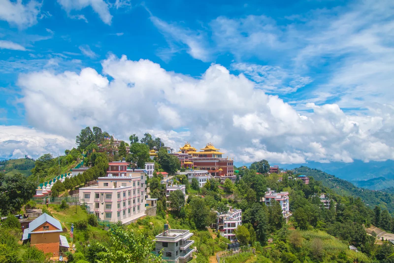
Namo Buddha Day Hike
A one-day walk from Dhulikhel through terraced farmland and forest to the Namo Buddha monastery hill (about 1,750 m) and down to the Newar town of Panauti, 19.4 km on our map.
- 日数1
- 最高標高1,750 m
- 距離18.8 km
- 累積上昇547 m
- 難易度易しい
- ベストシーズンMar–May, Sep–Nov
写真:Rukeshmdr12 · CC BY-SA 4.0
英語で表示しています(未翻訳)。
この行程は下書きで、まだ確認されていません。各区間は必ずガイドに確認してください。
Written by FindTrekkingPartner team確認者: FindTrekkingPartner team確認方法についてFindTrekkingPartner
Namo Buddha Day Hikeは、ネパールのKathmandu Valley地域にある1日間のトレッキングで、標高1,750 mまで登ります。外国人トレッカーは、FindTrekkingPartnerに日程、予算、ペースを添えてトリップを投稿すれば、このトレッキングのパートナーを探せます。マッチングは両者が同意するまで非公開で、サービスは無料です。 中級クラスの料金では、ライセンスを持つガイドの費用は、トレッカー4人でシェアすると1日間で1人あたり約USD 9、1人だけの場合はUSD 37です。ベストシーズンはOct–Nov, Mar–Aprです。 このような一般ルートでは、ライセンスガイドの同行は義務付けられていません(2026年10月19日確認)。クンブ自治体はネパール観光局の2023年4月の規則から外れる決定をしており、日帰りハイキングにはガイドは不要ですが、それでもガイドの同行を強くおすすめします。旅行会社に確認してください。 このルートの募集中のトリップを以下に表示します。出発月、グループ人数、残り枠を確認できます。 最終確認日: 2026年10月19日。出典: ネパール観光局、DNPWC、入国管理局。
出典:Department of Immigration, NepalNepal Tourism BoardDepartment of National Parks and Wildlife Conservation
Namo Buddha Day Hikeのパートナーを探す
- Namo Buddha Day Hikeのパートナーを探す募集中のトリップはまだありません
- Shivapuri Peak Day Hikeのパートナーを探す募集中のトリップはまだありません
- Nagarkot to Changu Narayan Day Hikeのパートナーを探す募集中のトリップはまだありません
- Chisapani Nagarkot Trekのパートナーを探す募集中のトリップはまだありません
- Champadevi Day Hikeのパートナーを探す募集中のトリップはまだありません
- Phulchowki Day Hikeのパートナーを探す募集中のトリップはまだありません
概要
Dhulikhelから出発1日間 · 最高 1,750 m
ベストシーズン:Mar–May, Sep–Nov
The Namo Buddha hike is a one-day walk from Dhulikhel, on the eastern rim of the Kathmandu Valley, through terraced farmland and forest to the Namo Buddha monastery hill, then downhill to the old Newar town of Panauti. On our map the walk is about 19.4 km with 610 m of climbing and 720 m of descent, partly on quiet roads. Operators allow five to six hours including rests, and one guide gives about two and a half hours from Dhulikhel to Namo Buddha and another two and a half to Panauti, a total of 14 to 16 km. We say allow six to seven hours, because our mapped route is longer. The highest point is about 1,750 m. A taxi from Kathmandu to Dhulikhel takes about an hour. None of our sources lists a permit.
The plan follows an operator itinerary and a day-trip guide that agree on the order, Dhulikhel to Namo Buddha to Panauti, and on the lunch stop at the monastery hill. Our map follows roads and tracks because OpenStreetMap has few footpaths here, so it is longer than the guide's 14 to 16 km.
What the hike is like
The trail leaves Dhulikhel through villages and terraced fields, with patches of forest, and climbs gently to Namo Buddha, where Thrangu Tashi Yangtse monastery stands with golden roofs above a stupa. According to Wikipedia, the site recalls a past life of the Buddha who gave his body to save a tigress and her cubs. A stairway through the woods links the stupa to the legend site. After lunch the way drops towards Panauti, an ancient Newari town.
Permits and rules
None of our sources lists a permit or park fee. Monuments and monasteries may charge small entrance fees; operator pages include them in their price without giving amounts. Remove shoes before entering temples and dress modestly.
Best season
Spring (March to May) and autumn (September to November) are the most popular, according to an operator, and winter and monsoon walks are possible.
Getting there and away
Dhulikhel is about an hour by taxi from Kathmandu, or an operator transfer of about 1.5 hours. Local buses run from Ratna Park to Dhulikhel. From Panauti local buses also run from Ratna Park with changes involved, and a taxi is simpler.
Difficulty and fitness
The walk is easy to moderate: 610 m of climbing spread over most of a day. Carry water and a packed lunch, and start by 8 am to reach Panauti before dark.
Budget notes
There is no permit fee. Pay for a taxi or bus to Dhulikhel and a taxi from Panauti, plus lunch. The costs section shows the taxis as lines to check.
ハイライト
- Namo Buddha, a Buddhist pilgrimage site above terraced fields
- Thrangu Tashi Yangtse monastery with its golden roofs
- Terraces, villages and forest between Dhulikhel and Panauti
- Panauti, an old Newar town at the end of the walk
- Mostly gentle going with little altitude gain
ルートマップ
ルートデータはOpenStreetMapのもので、まだ当チームで確認していません。計画の参考にとどめ、ナビゲーションには使わないでください。
日ごとの行程
費用
1人あたりの総額の目安です。標高別のロッジと食事、交通費、許可証、ガイドとポーターが含まれます。ガイドとポーターを分け合うトレッカーが多いほど、1人あたりの負担は小さくなります。 2026年10月時点
| スタイル | 1人で分担 | 2人で分担 | 4人で分担 |
|---|---|---|---|
| 節約 | — | — | — |
| 標準 | $40–$80* | $20–$40* | $10–$30* |
| 快適 | $40–$80* | $30–$50* | $20–$40* |
ガイドを分け合って節約
中価格帯の場合、1人で歩くと約$40–$80です。4人で1人のガイドと2人のポーターを分け合うと、1人あたり約$10–$30になります(最大で66%安くなります)。
2人で分担する場合の内訳
| 項目 | 節約 | 標準 | 快適 |
|---|---|---|---|
| ガイド | — | $10–$30 | $10–$30 |
| ポーター | — | $0–$20 | $10–$30 |
予算重視は公共交通機関を使い、ポーターなしです。中価格帯は2人で1人のポーターを分け合い、車は貸切です。快適重視は各自にポーターが付きます。ガイドは、必須の場合、またはスタイルが中価格帯か快適重視の場合に含まれます。
含まれないもの
公表されている料金が見つかりませんでした:Kathmandu to Dhulikhel by taxi; Panauti to Kathmandu by taxi。*印の合計にはこれらが含まれていません。旅行会社にご確認ください。 A day hike: no lodging and no permit. A guide is optional.
費用の情報源
- PriceNepal: Nepal Travel Cost Guide 2026 (2026-05-14)
- Third Rock Adventures: Nepal trek budget planner (2026-05-09)
- Himalayan Partner: Guide and porter price in Nepal 2026 (2026-02-10)
- Shikhar Adventure: Annapurna Circuit trek cost (2026-02-03)
- Nepal Tourism Board: Trekking Permit (2026-10-18)
ツアー会社のガイドに基づく見積もりで、正式な見積書ではありません。チップ、保険、装備、カトマンズのホテル代は含まれません。USDはプラットフォームの為替レートによります。
写真
よくある質問
Operators allow five to six hours including rests. One guide gives about 2.5 hours from Dhulikhel to Namo Buddha and another 2.5 to Panauti, 14 to 16 km. Our mapped route is 19.4 km, so allow six to seven hours.
An operator gives a maximum height of about 1,750 m for the hike.
None of our sources lists a permit or park fee. Operator prices include small monument entrance fees without naming amounts.
Our plan and the operator itinerary go from Dhulikhel to Namo Buddha for lunch and then downhill to Panauti, which keeps the climbing gentle.
Take a taxi from Panauti, about an hour, which a day-trip guide calls simpler than local buses that involve changes.
情報源
トレイル沿い
ルートの各日にある宿泊施設、医療、水場、見どころです。
1. Dhulikhel → Panauti
- Dhulikhel Hospital · 医療 · 1,523 m
- Dhulikhel Clinic Center · 医療 · 1,501 m
- Pond · 実用情報 · 1,549 m
- Water Tank · 実用情報 · 1,658 m
- Bhimsensthan Viewpoint · 展望ポイント · 1,546 m
- V-sign Guest House · 宿泊 · 1,449 m
- Maneshwori Mo:Mo · 宿泊 · 1,447 m
- Namaste Samudai Home Stay · 宿泊 · 1,450 m
Show all 53 places
- R.K Pharmacy · 医療 · 1,525 m
- Achutan Pharmacy · 医療 · 1,524 m
- Balaram Pharmacy · 医療 · 1,525 m
- Dhulikhel Hospital · 医療 · 1,523 m
- Dhulikhel Clinic Center · 医療 · 1,501 m
- Ku Helipad · 空港・交通 · 1,470 m
- Pediatrics and Gyn/Obs · 医療 · 1,510 m
- Pond · 実用情報 · 1,549 m
- Love Bird · 宿泊 · 1,550 m
- Dada Pari Lama Hotel · 宿泊 · 1,555 m
- Sanu Khaja Ghar · 宿泊 · 1,556 m
- Star Momo · 宿泊 · 1,556 m
- Sanjibani Newari Khaja Ghar · 宿泊 · 1,558 m
- Timal Hotel · 宿泊 · 1,558 m
- Bishal Hotel · 宿泊 · 1,558 m
- Mama ko hotel · 宿泊 · 1,558 m
- Roshi bhojanalaye · 宿泊 · 1,557 m
- Sanjibani · 宿泊 · 1,559 m
- Krishna bhojanayala · 宿泊 · 1,559 m
- Water Tank · 実用情報 · 1,658 m
- Drinking Water · 実用情報 · 1,536 m
- Bhimsensthan Viewpoint · 展望ポイント · 1,546 m
- Hotel Green Peace Lodge And Resort · 宿泊 · 1,547 m
- Pancha tamang hotel · 宿泊 · 1,703 m
- Aahana Pharmacy · 医療 · 1,667 m
- Ram Gopal Baidya Medical Centre · 医療 · 1,640 m
- Sornim Phamacy · 医療 · 1,640 m
- Kulung hotel · 宿泊 · 1,704 m
- Namobuddha Hotel And Lodge · 宿泊 · 1,707 m
- Thrangu Phende Clinic · 医療 · 1,721 m
- Stupa view point · 展望ポイント · 1,760 m
- Viewpoint · 展望ポイント · 1,757 m
- Namobuddha Motel · 宿泊 · 1,672 m
- Sankhu Homestay · 宿泊 · 1,514 m
- Pariwar Syasthya Clinic · 医療 · 1,454 m
- Prathamik Swasthya Kendra, Sunthan · 医療 · 1,499 m
- Panauti Hospital · 医療 · 1,453 m
- Rebika Pharmacy · 医療 · 1,454 m
- Krishnamohan Pharmacy · 医療 · 1,454 m
- Samudayik ATM · 実用情報 · 1,450 m
- V-sign Guest House · 宿泊 · 1,449 m
- Machhe Pharmacy · 医療 · 1,449 m
- Maneshwori Mo:Mo · 宿泊 · 1,447 m
- Bhairab Hospital · 医療 · 1,450 m
- Prakash Drug House · 医療 · 1,447 m
- Karmacharya Pharma · 医療 · 1,450 m
- SomSarobar Medical Hall · 医療 · 1,447 m
- Rehab Center · 医療 · 1,471 m
- Red Cross · 医療 · 1,457 m
- Panauti Public Health Post · 医療 · 1,452 m
- Namaste Samudai Home Stay · 宿泊 · 1,450 m
- Tap (Dhunge Dharo) · 実用情報 · 1,452 m
- Gita devi ozone mart · 医療 · 1,444 m