

Drive from Kathmandu to Chhimti through Melamchi, about five to six hours depending on traffic and road works, then start walking. The trail climbs about 6 km and 1,050 m through forest and terraces to Tuppi Danda, in about four hours, and the lodge there is your first night. Operators give two different heights for Tuppi Danda, 2,019 m and 2,320 m, and the elevation model puts the stop near 2,900 m, so we state none. Walk slowly and drink plenty: you gain over a thousand metres on your first afternoon, straight after a long drive. Pack snacks and water at Chhimti.
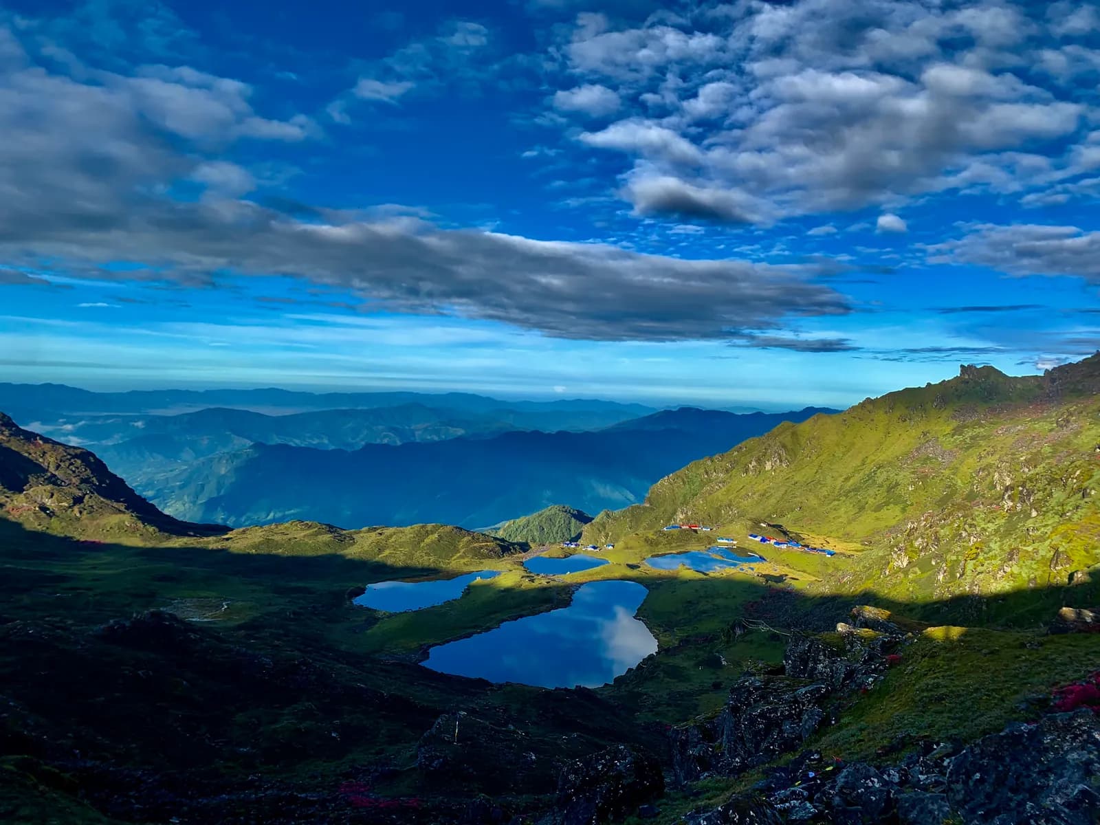
Panch Pokhari Trek
A five-day trek from Chhimti, near Melamchi, up through Tuppi Danda and Nesyampati to the five sacred lakes of Panch Pokhari at about 4,100 m in the Jugal Himal.
- 日数5
- 最高標高4,100 m
- 距離33.2 km
- 累積上昇2,813 m
- 難易度普通–難しい
- ベストシーズンMar–May, Oct–Nov
- 許可証3
写真:RiCEKiLLER · CC BY-SA 4.0
英語で表示しています(未翻訳)。
この行程は下書きで、まだ確認されていません。各区間は必ずガイドに確認してください。
Written by FindTrekkingPartner team確認者: FindTrekkingPartner team確認方法についてFindTrekkingPartner
Panch Pokhari Trekは、ネパールのJugal Himal地域にある5日間のトレッキングで、標高4,100 mまで登ります。外国人トレッカーは、FindTrekkingPartnerに日程、予算、ペースを添えてトリップを投稿すれば、このトレッキングのパートナーを探せます。マッチングは両者が同意するまで非公開で、サービスは無料です。 中級クラスの料金では、ライセンスを持つガイドの費用は、トレッカー4人でシェアすると5日間で1人あたり約USD 47、1人だけの場合はUSD 187です。ベストシーズンはMar–May, Oct–Novです。 ここでは実際にはライセンスガイドが必要です。ネパール観光局の2023年4月の規則は、2026年の旅行会社の報告によると国立公園と保全地域のチェックポイントで実施されており、ランタンが最も厳しく、アンナプルナも確認があります(2026年10月19日確認)。登録済みの旅行会社を通じてガイドを手配し、旅行会社に確認してください。 このルートの募集中のトリップを以下に表示します。出発月、グループ人数、残り枠を確認できます。 最終確認日: 2026年10月19日。出典: ネパール観光局、DNPWC、入国管理局。
出典:Department of Immigration, NepalNepal Tourism BoardDepartment of National Parks and Wildlife Conservation
Panch Pokhari Trekのパートナーを探す
- Panch Pokhari Trekのパートナーを探す募集中のトリップ 3 件
概要
Kathmanduから出発5日間 · 最高 4,100 m
ベストシーズン:Mar–May, Oct–Nov · 許可証:No restricted-area permit, TIMS card where your agency requires it, Ask your agency about a park or local fee: the lakes lie near Langtang National Park
The Panch Pokhari trek is a five-day walk from the road at Chhimti, a few hours north of Melamchi, to a cluster of five alpine lakes at about 4,100 m below the Jugal Himal in Sindhupalchok District. It starts with a five to six hour drive from Kathmandu, then climbs about 6 km to the night stop at Tuppi Danda, continues to the hotel at Nesyampati at about 3,700 m, and reaches the lakes on the third day. The lakes are sacred to Hindus and Buddhists, and pilgrims come in August for Janai Purnima. The return follows the same trail, so the trek is out and back, with about 33 km of walking and 2,800 m of climbing in total. The trail is mostly a footpath and only partly marked, lodging is basic, and nights at 3,700 m and 4,100 m are cold.
The plan follows the short route described by Nepal Traveller, which gives the Chhimti start, the stop at Tuppi Danda and the timings, and it uses the Nesyampati and lake heights that two operators agree on. A longer route from Chautara, ten to sixteen days with camping, joins the same trail at Nesyampati. The lakes are not a restricted area, but ask your agency about any park or local fee, because the area lies next to Langtang National Park. The best months are March to May and October to November, when the weather is steady and the views of Dorje Lakpa are at their best.
Difficulty and fitness
The trek is moderate to hard for its length. You climb about 2,500 m in three days, sleep at about 3,700 m and 4,100 m, and the descent on day four is long. It suits fit walkers who have trekked before and know how they respond to altitude. Poles help on the descent, and a spare day after the trek covers road delays.
Budget notes
Nepal Traveller quotes NPR 7,000 to 10,000 per person for the short trek including transport, meals and lodging, which reflects independent travel on a budget. Our estimate on the costs section uses Nepal-wide lodge and meal ranges plus a guide, a porter and road transport, and shows the fare for the road as a line to check.
What to pack
A warm sleeping bag, down jacket, hat and gloves for nights at 3,700 m and 4,100 m, waterproofs, poles, water treatment and a head torch. Lodges are basic, so carry snacks.
ハイライト
- Panch Pokhari, five alpine lakes at about 4,100 m under Dorje Lakpa and Phurbi Chyachu
- A viewpoint about 45 minutes above the lakes at about 4,300 m
- Tamang hill villages and forest between Chhimti and Nesyampati
- A quiet trail close to Kathmandu, with no restricted-area permit
- Janai Purnima in August, when pilgrims bathe in the lakes
ルートマップ
ルートデータはOpenStreetMapのもので、まだ当チームで確認していません。計画の参考にとどめ、ナビゲーションには使わないでください。
日ごとの行程
A climb of about 5.7 km and 850 m takes four to five hours, by our estimate, from Tuppi Danda through forest and past Ratomato and Chokkardada, a ridge at about 3,100 m, to Nesyampati, where a hotel stands at about 3,700 m. The Nepal Traveller guide names a homestay and lodge here, and two operators agree on the height. The forest thins and the trail crosses rock and grass as you climb. It is a short day by distance, so there is time to rest, and a second night above 3,500 m is the best acclimatisation you can give yourself before the lakes.
A climb of about 4.9 km and 600 m, four to five hours, leads from Nesyampati through rock and tussock to Panch Pokhari, at about 4,100 m. Nepal Traveller says four hours and operators say five to six, and our estimate falls between. The five lakes lie in a shallow basin under the Jugal Himal, and a hotel stands beside them. In the afternoon you can walk about 45 minutes to a viewpoint at about 4,300 m, or rest. It is the highest night of the trek, and it will be cold, so bring a warm sleeping bag and hat.
Start early. A 30 to 60 minute walk to a viewpoint above the lakes at sunrise is optional, and then the long descent begins: about 10.6 km and 1,440 m down to Tuppi Danda, six to seven hours with the viewpoint, according to the operator itinerary. The trail is steep and rocky near the top and hard on the knees below, so use poles. You pass Nesyampati and Chokkardada on the way. Most of the descent is on loose path, and in rain or snow it is slippery. The lodge at Tuppi Danda is a welcome stop after the long day.
A walk of about 6 km, mostly downhill with 1,050 m of descent, takes you to Chhimti in about two hours, according to the Nepal Traveller guide. A vehicle meets you at the road and drives you back to Kathmandu through Melamchi in five to six hours, so you reach the city in the evening. Keep a margin for road conditions: landslides and road works between Melamchi and Chhimti can add hours, particularly after rain. If your flight home is the same night, leave a spare day after the trek.
高度順応
夜ごとの宿泊標高です。赤いバーは前の晩から500 mを超えて上がる日、休息日には印が付いています。
- 宿泊標高
- 500 m超の上昇
- 休息日
費用
1人あたりの総額の目安です。標高別のロッジと食事、交通費、許可証、ガイドとポーターが含まれます。ガイドとポーターを分け合うトレッカーが多いほど、1人あたりの負担は小さくなります。 2026年10月時点
| スタイル | 1人で分担 | 2人で分担 | 4人で分担 |
|---|---|---|---|
| 節約 | $110–$180* | $110–$180* | $110–$180* |
| 標準 | $360–$550* | $250–$390* | $210–$330* |
| 快適 | $400–$610* | $330–$500* | $290–$440* |
ガイドを分け合って節約
中価格帯の場合、1人で歩くと約$360–$550です。4人で1人のガイドと2人のポーターを分け合うと、1人あたり約$210–$330になります(最大で40%安くなります)。
2人で分担する場合の内訳
| 項目 | 節約 | 標準 | 快適 |
|---|---|---|---|
| ロッジと食事 | $100–$160 | $130–$210 | $170–$270 |
| 許可証 | $10–$20 | $10–$20 | $10–$20 |
| ガイド | — | $70–$120 | $70–$120 |
| ポーター | — | $30–$60 | $60–$110 |
予算重視は公共交通機関を使い、ポーターなしです。中価格帯は2人で1人のポーターを分け合い、車は貸切です。快適重視は各自にポーターが付きます。ガイドは、必須の場合、またはスタイルが中価格帯か快適重視の場合に含まれます。
1泊あたりのロッジと食事(部屋とダルバート1食)
3泊 2,500 to 3,800 m:部屋 $4–$11、ダルバート $5–$11 · 1泊 Above 3,800 m:部屋 $7–$19、ダルバート $8–$13
許可証の料金(公的情報源)
- TIMS card (trekking agency issued): NPR 2,000 入域1回あたり 情報源
含まれないもの
公表されている料金が見つかりませんでした:Kathmandu to Chhimti by road (return)。*印の合計にはこれらが含まれていません。旅行会社にご確認ください。 Lodges at Tuppi Danda, Nesyampati and the lakes are basic. Nepal Traveller quotes NPR 7,000 to 10,000 per person for the short trek including transport; the road fare is not in this estimate. Ask your agency whether a park or local fee applies.
費用の情報源
- PriceNepal: Nepal Travel Cost Guide 2026 (2026-05-14)
- Third Rock Adventures: Nepal trek budget planner (2026-05-09)
- Himalayan Partner: Guide and porter price in Nepal 2026 (2026-02-10)
- Shikhar Adventure: Annapurna Circuit trek cost (2026-02-03)
- Nepal Tourism Board: Trekking Permit (2026-10-18)
ツアー会社のガイドに基づく見積もりで、正式な見積書ではありません。チップ、保険、装備、カトマンズのホテル代は含まれません。USDはプラットフォームの為替レートによります。
写真
よくある質問
This plan takes five days from Kathmandu to Kathmandu: one day of driving and walking up to Tuppi Danda, two climbing days to Nesyampati and the lakes, and two days down. Nepal Traveller describes a four-day version that goes from Tuppi Danda to the lakes in a single long day, and operators sell fifteen and sixteen day plans from Chautara.
About 4,100 m. Wikipedia, Nepal Traveller and two operators agree, and the elevation model gives about 4,060 m at the lake. A viewpoint above the lakes at about 4,300 m is a 30 to 45 minute walk.
The area is not on the Nepal Tourism Board's restricted-area list, so you do not need a Department of Immigration permit. Wikipedia places the lakes near Langtang National Park, and we found no official page that sets a fee for this trek, so ask your agency what it has arranged. A TIMS card may be requested.
March to May and October to November have the steadiest weather. Winter is possible with snow equipment, and in August the lakes are crowded with pilgrims at Janai Purnima, so book lodging early or avoid that week.
There are basic lodges at Tuppi Danda, a homestay and lodge at Nesyampati and a hotel at the lakes, according to Nepal Traveller. Operators note that some sections of the longer routes have no settlement, so those plans use tents.
情報源
トレイル沿い
ルートの各日にある宿泊施設、医療、水場、見どころです。
1. Kathmandu → Tuppi Danda
この日のスポットはまだマッピングされていません。この日のスポットはまだマッピングされていません。2. Tuppi Danda → Nesyampati
この日のスポットはまだマッピングされていません。この日のスポットはまだマッピングされていません。3. Nesyampati → Panch Pokhari
- Nesyampati · 宿泊 · 3,657 m
- Nasim Pati 3,700m · 展望ポイント · 3,658 m
- Paanchpokhari · 自然 · 4,062 m
4. Panch Pokhari → Tuppi Danda
- Paanchpokhari · 自然 · 4,056 m
- Paanch Pokhari · 実用情報 · 4,050 m
5. Tuppi Danda → Kathmandu
この日のスポットはまだマッピングされていません。この日のスポットはまだマッピングされていません。
最終確認日:2026/10/19古い情報を報告