

Drive from Kathmandu to Besisahar and on up the Marsyangdi valley to Dharapani, at 1,860 m, a long day of nine to ten hours on winding roads. The valley is steep and green, with waterfalls and terraced villages, and the road continues beyond Besisahar on jeep track. Dharapani has a few lodges beside the river and is the junction with the trail to Manaslu. If you want an easier first day you can begin walking at Besisahar or Bulbule instead. Check your gear, drink plenty of water and get an early night; tomorrow's walk is the first full day on foot.
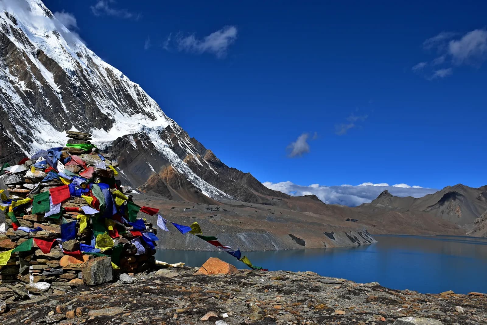
Tilicho Lake Trek
A 10-day Marsyangdi valley trek from Dharapani to Manang, then the loop to Tilicho Base Camp and the glacial lake at about 4,920 m.
- दिन10
- अधिकतम ऊँचाई4,920 मी
- दूरी87.8 किमी
- चढ़ाई5,316 मी
- कठिनाईकठिन
- सबसे अच्छे महीनेMar–May, Oct–Nov
- परमिट2
इस यात्रा-कार्यक्रम के साथ ट्रिप की योजना बनाएँTilicho Lake Trek के लिए पार्टनर खोजेंहफ़्ते के अनुसार प्रस्थान देखें
फ़ोटो: Prabeshsdev · CC BY-SA 4.0
अंग्रेज़ी में दिखाया गया — अभी अनुवाद नहीं हुआ।
यह यात्रा-कार्यक्रम ड्राफ़्ट है और अभी सत्यापित नहीं हुआ है। चरणों की पुष्टि हमेशा अपने गाइड से करें।
Written by FindTrekkingPartner teamFindTrekkingPartner team द्वारा समीक्षितहम समीक्षा कैसे करते हैंFindTrekkingPartner
Tilicho Lake Trek नेपाल के Annapurna क्षेत्र में 10 दिन का ट्रेक है, जो 4,920 मीटर तक चढ़ता है। विदेशी ट्रेकर FindTrekkingPartner पर अपनी तारीखों, बजट और रफ़्तार के साथ ट्रिप पोस्ट करके इसके लिए पार्टनर खोज सकते हैं। मैच तब तक निजी रहते हैं जब तक दोनों ट्रेकर सहमत न हों, और सेवा मुफ़्त है। मध्यम दरों पर लाइसेंस प्राप्त गाइड का खर्च चार ट्रेकर के साझा करने पर 10 दिनों में प्रति व्यक्ति लगभग USD 63 है, जबकि अकेले एक ट्रेकर के लिए USD 250। सबसे अच्छे मौसम Mar–May, Oct–Nov हैं। यहां व्यवहार में लाइसेंस प्राप्त गाइड ज़रूरी है: 2026 के ऑपरेटरों के अनुसार नेपाल पर्यटन बोर्ड का अप्रैल 2023 का नियम राष्ट्रीय उद्यानों और संरक्षण क्षेत्रों की चौकियों पर लागू किया जाता है, जिसमें लांगटांग सबसे सख़्त है और अन्नपूर्णा भी जांच करता है (19 अक्टूबर 2026 को जांचा गया)। पंजीकृत एजेंसी के माध्यम से गाइड रखें और उनसे पुष्टि करें। अंतिम सत्यापन: 21 अक्टूबर 2026। स्रोत: नेपाल पर्यटन बोर्ड, DNPWC, आव्रजन विभाग।
स्रोत:Department of Immigration, NepalNepal Tourism BoardDepartment of National Parks and Wildlife Conservation
Tilicho Lake Trek के लिए पार्टनर खोजें
- Tilicho Lake Trek के लिए पार्टनर खोजें5 खुली ट्रिप
- Annapurna Base Camp Trek के लिए पार्टनर खोजें25 खुली ट्रिप
- Annapurna Circuit Trek के लिए पार्टनर खोजें4 खुली ट्रिप
- Poon Hill Trek (Ghorepani) के लिए पार्टनर खोजें3 खुली ट्रिप
- Mardi Himal Trek के लिए पार्टनर खोजें27 खुली ट्रिप
- Khopra Ridge Trek के लिए पार्टनर खोजेंअभी कोई खुली ट्रिप नहीं
परिचय
Kathmandu से शुरू10 दिन · अधिकतम 4,920 मी
सबसे अच्छा मौसम: Mar–May, Oct–Nov · परमिट: Annapurna Conservation Area entry permit, TIMS card where required
Tilicho Lake is a glacial lake in Manang District, at about 4,920 m in our route data, reached by a side trip from Manang that has become a trek in its own right. This 10-day plan drives from Kathmandu to Dharapani, walks up the Marsyangdi valley through Chame, Upper Pisang and Ngawal to Manang, rests there for a day, then loops out to Khangsar, Tilicho Base Camp (about 4,140 m) and the lake before returning to Manang, where the trek ends. It is a serious high-altitude trek: the climb from Base Camp to the lake is about 800 m on loose scree, and a landslide zone between Shree Kharka and Base Camp is open but risky, so you cross early and take local advice. It suits fit walkers who have already acclimatised well in Manang and who want a guide for the exposed stretch.
What the trek is like
The first five days follow the same valley as the Annapurna Circuit, from wet forest and waterfalls below Chame to drier, Tibetan-style villages with chortens, mani walls and apple orchards. The high trail through Ghyaru and Ngawal gives long views of Annapurna II, Annapurna III, Gangapurna and Tilicho Peak. Beyond Manang the country turns bare and quiet. Lodges at Khangsar and Shree Kharka are simple and Base Camp is basic, with cold nights, short menus and limited charging, so bring a warm sleeping bag and cash.
How it is built
We model Tilicho as a stand-alone route that shares its approach with the Circuit: it uses the same road-and-trail stages as far as Manang and then adds the loop. Many trekkers instead add the lake as two or three extra days on the Circuit itself; if you want to carry on over Thorong La at 5,416 m afterwards, see the Annapurna Circuit route. Altitudes for Khangsar and Shree Kharka differ by more than 100 m between published itineraries, so treat the figures here as approximate and confirm the stages with your guide in Manang.
Permits, guide and season
You need an Annapurna Conservation Area entry permit and a TIMS card where required. The guide rule as we last checked it is this: a licensed guide through a registered agency is required in restricted areas (Department of Immigration) and, under the Nepal Tourism Board rule of April 2023, in national parks and conservation areas, where 2026 operator reports say checkpoints enforce it in Annapurna and Langtang but not in Khumbu (checked 19 October 2026). Tilicho is inside the conservation area, and the landslide section makes a guide sensible in any case. The best windows are March to May and October to November; snow can block the high sections in early spring and late autumn.
Sharing the trip
A guide and porter for the extra days are shared costs, which is why this route suits a small group. Post your dates, then agree the plan, turnaround time and what happens if someone has symptoms at altitude before you leave Manang.
मुख्य आकर्षण
- Tilicho Lake at about 4,920 m
- Ghyaru and Ngawal high trail
- Manang acclimatisation day
- Tilicho Base Camp (about 4,140 m)
- Landslide section crossed at first light
रूट मैप
रूट डेटा OpenStreetMap से है, हमारी टीम ने अभी जाँचा नहीं है। इसे प्लानिंग के लिए इस्तेमाल करें, नेविगेशन के लिए नहीं।
दिन-ब-दिन
आप पिछली रात से 810 मी ऊँचाई पर सोएँगे, जो 500 मी की सामान्य सीमा से ज़्यादा है। धीरे चलें, खूब पानी पिएँ और सिरदर्द या मतली पर नज़र रखें।
Walk up the Marsyangdi valley through Bagarchhap, Danaque and Timang, where Manaslu and Peri Himal appear to the north. The path follows the road in places and keeps to the river in others; the forest of pine and oak thins as you climb. Chame, at 2,670 m, is the headquarters of Manang district and has a bank machine, shops and hot springs a short walk from the village. The air is thinner here, and the first views of Lamjung Himal and Annapurna II appear. Rest and watch the evening light on the peaks.
आप पिछली रात से 630 मी ऊँचाई पर सोएँगे, जो 500 मी की सामान्य सीमा से ज़्यादा है। धीरे चलें, खूब पानी पिएँ और सिरदर्द या मतली पर नज़र रखें।
Continue along the Marsyangdi, crossing to Bhratang and walking through a dry pine forest below the huge curved rock face of Paungda Danda. The valley opens at Dhikur Pokhari, with its views of Annapurna II, and the trail climbs to Upper Pisang, at 3,300 m, a village of stone houses above the road. The village has a small monastery and wide views. The landscape is now Tibetan in character, with chortens, prayer flags and apple orchards. Decide here whether to take the high trail through Ghyaru tomorrow; it is worth the effort.
Take the upper route from Upper Pisang, a steep climb through juniper to Ghyaru, at about 3,700 m, and onward along the ridge to Ngawal at 3,600 m. The path is one of the finest on the circuit: Annapurna II, Annapurna III, Gangapurna and Tilicho Peak fill the view south, and you can see the entire Manang valley below. The villages are old and the houses are stacked up the hillside. The lower route through Humde is faster but less scenic. The altitude gain is modest, but the path is steep, so go slowly and keep your water close.
Descend gently from Ngawal to Braka, pass Mugje, and walk into Manang, at 3,540 m, via the airstrip at Humde. Manang is a Tibetan-influenced village with stone alleys, bakeries and a small cinema, and the view of Gangapurna and Annapurna III from the lodges is spectacular. In the afternoon, visit the Himalayan Rescue Association post, which gives a talk on altitude sickness in the trekking seasons. It is a short day and a chance to rest, wash your clothes and explore. Drink water throughout, and watch for headaches.
Spend a full day in Manang before heading higher. Walk up to the viewpoint above Gangapurna Lake or climb toward Ice Lake (Kicho Tal) at about 4,600 m, then come back down to sleep at 3,540 m. The Tilicho loop takes you above 4,900 m, so treat this as the first half of your preparation, not a spare day. Visit the Himalayan Rescue Association post for its altitude talk, ask lodge owners and your guide how the trail beyond Shree Kharka looks this week, and settle on a turnaround time for the lake. If you had headaches or poor sleep here, stay another night or skip the lake.
Leave Manang for Khangsar, a small village above the Marsyangdi on the trail that branches toward Tilicho. Expect roughly four to six hours depending on whether you stop at Khangsar or press on to Shree Kharka, which sits a little higher; published itineraries give Khangsar at about 3,734 to 3,756 m. The country is drier and barer than the main valley, with long views back to Gangapurna and the Annapurna wall. Keep the day short and sleep low enough that the next climb feels manageable. Pay attention to how you feel, as tomorrow takes you past the landslide section and above 4,100 m.
Today you pass Shree Kharka and reach Tilicho Base Camp at about 4,140 m, a short day by distance but a serious one. Between Shree Kharka and Base Camp the path crosses a landslide zone that operators describe as open but risky, with wind and falling stones building later in the morning. Cross early, keep spacing between walkers, follow your guide and be ready to turn back if it looks worse than reported. Phone signal is patchy here. Base Camp lodging is basic and nights are cold, so arrive with enough time to warm up, eat and drink well and go to bed early.
आप पिछली रात से 780 मी ऊँचाई पर सोएँगे, जो 500 मी की सामान्य सीमा से ज़्यादा है। धीरे चलें, खूब पानी पिएँ और सिरदर्द या मतली पर नज़र रखें।
Start before dawn with a headlamp for the climb of about 800 m on loose scree to Tilicho Lake, listed at about 4,920 m in our route data. Go slowly, drink often and agree a turnaround time with your guide before you leave, because wind builds through the morning and the scree is unpleasant in a gale. At the top you look over a large, cold, blue lake in a bare glacial cirque with snow peaks around it, so plan time for photos and a hot drink if the lodge there is open. Descend carefully and aim to be back at Base Camp for an early-afternoon lunch and a second night at 4,140 m.
Walk back down toward Manang at 3,540 m, crossing the landslide section again, so start early and keep the same discipline as on the way up. Operators vary on how they split the return: some go straight back, others sleep at Shree Kharka or Khangsar. Agree it with your guide the evening before, based on how the group feels and what the trail looks like. In Manang you rejoin the main Circuit trail; from here you can continue toward Yak Kharka and Thorong La if you have the time and are well, or head back down the Marsyangdi valley by road.
अनुकूलन
रात-दर-रात सोने की ऊँचाई। लाल बार पिछली रात से 500 मी से ज़्यादा चढ़ाई दिखाते हैं; आराम के दिन चिह्नित हैं।
- सोने की ऊँचाई
- 500 मी से ज़्यादा बढ़ोतरी
- आराम का दिन
कितना खर्च होता है
प्रति व्यक्ति कुल अनुमानित खर्च: ऊँचाई के हिसाब से लॉज और खाना, परिवहन, परमिट, और गाइड व पोर्टर। जितने ज़्यादा ट्रेकर्स गाइड और पोर्टर साझा करते हैं, हर व्यक्ति उतना कम देता है। अक्टूबर 2026 तक।
| स्टाइल | 1 ट्रेकर | 2 ट्रेकर साथ में | 4 ट्रेकर साथ में |
|---|---|---|---|
| किफ़ायती | $510–$730* | $400–$580* | $350–$510* |
| मध्यम बजट | $1,000–$1,500* | $680–$980* | $550–$800* |
| आरामदायक | $1,050–$1,600* | $830–$1,250* | $710–$1,050* |
गाइड साझा करें, पैसे बचाएँ
मध्यम श्रेणी में अकेला ट्रेकर लगभग $1,000–$1,500 देता है; एक गाइड और दो पोर्टर साझा करने वाले चार ट्रेकर्स हर एक लगभग $550–$800 देते हैं (ऊपरी सीमा पर 46% कम)।
साथ में 2 ट्रेकर्स के लिए ब्योरा
| मद | किफ़ायती | मध्यम बजट | आरामदायक |
|---|---|---|---|
| लॉज और खाना | $250–$350 | $310–$450 | $390–$560 |
| परिवहन | $10–$50 | $140–$230 | $140–$230 |
| परमिट | $30–$40 | $30–$40 | $30–$40 |
| गाइड | $100–$150 | $100–$150 | $100–$150 |
| पोर्टर | — | $70–$130 | $150–$260 |
बजट में सार्वजनिक परिवहन है और पोर्टर नहीं; मध्यम में दो ट्रेकर्स के बीच एक पोर्टर और निजी वाहन है; आरामदायक में हर ट्रेकर को एक पोर्टर मिलता है। जहाँ गाइड ज़रूरी है या स्टाइल मध्यम या आरामदायक है, वहाँ गाइड शामिल है।
प्रति रात लॉज और खाना (कमरा और एक दाल भात)
1 रात Below 2,500 m: कमरा $2–$6, दाल भात $4–$7 · 7 रातें 2,500 to 3,800 m: कमरा $4–$9, दाल भात $5–$9 · 2 रातें Above 3,800 m: कमरा $10–$15, दाल भात $10–$12
परमिट शुल्क (आधिकारिक स्रोत)
शामिल नहीं
इनके लिए कोई प्रकाशित कीमत नहीं मिली: Besisahar to Dharapani jeep; Manang to Besisahar jeep। * से चिह्नित कुल में ये शामिल नहीं हैं; अपनी एजेंसी से पूछें।
खर्च के स्रोत
- PriceNepal: Nepal Travel Cost Guide 2026 (2026-05-14)
- Third Rock Adventures: Nepal trek budget planner (2026-05-09)
- Himalayan Partner: Guide and porter price in Nepal 2026 (2026-02-10)
- Shikhar Adventure: Annapurna Circuit trek cost (2026-02-03)
ऑपरेटर गाइड से अनुमान, कोटेशन नहीं। टिप, बीमा, गियर और काठमांडू के होटल शामिल नहीं हैं; USD प्लेटफ़ॉर्म की विनिमय दर पर।
फ़ोटो
अक्सर पूछे जाने वाले सवाल
About 4,919 m according to Wikipedia, with another source giving 4,949 m; our route data uses about 4,920 m. Tilicho Base Camp is usually given as about 4,140 m.
One section between Shree Kharka and Base Camp crosses a landslide zone that operators describe as open but risky, with wind and rockfall later in the morning. Cross early, follow your guide and check the current condition in Manang.
Our route data lists an Annapurna Conservation Area entry permit and a TIMS card where required, the same as the Annapurna Circuit. Ask your agency whether anything else applies.
Tilicho is inside the Annapurna Conservation Area, where 2026 operator reports say checkpoints enforce the guide rule (checked 19 October 2026). The landslide section makes a guide sensible regardless.
March to May and October to November, the same windows as the Circuit. Snow can block the high sections in early spring and late autumn.
Yes. Many trekkers add it as two or three extra days from Manang and then continue toward Thorong La; this route covers the lake as its own trek.
स्रोत
ट्रेल के किनारे
रूट के हर दिन ठहरने की जगहें, चिकित्सा सहायता, पानी और देखने लायक जगहें।
1. Kathmandu → Dharapani
- त्रिभुवन अन्तर्राष्ट्रीय विमानक्षेत्र · हवाई अड्डे और परिवहन · 1,340 मी
2. Dharapani → Chame
- Hayenga Waterfall · प्रकृति · 2,053 मी
- Viewpoint · व्यूपॉइंट · 1,840 मी
- ACAP Safe Drinking Water Station · ज़रूरी सुविधाएँ · 2,162 मी
- Hotel Four Seasons · ठहरने की जगहें · 2,676 मी
- Moonlight Hotel · ठहरने की जगहें · 2,676 मी
- Hotel Manasulu View · ठहरने की जगहें · 2,678 मी
- Trekkers Holiday Holtel · ठहरने की जगहें · 2,678 मी
Show all 23 places
- Hayenga Waterfall · प्रकृति · 2,053 मी
- Manaslu Hotel Restaurant · ठहरने की जगहें · 1,820 मी
- Hayat Guest House · ठहरने की जगहें · 1,818 मी
- Viewpoint · व्यूपॉइंट · 1,840 मी
- Peaceful Hotel · ठहरने की जगहें · 1,876 मी
- Gyasumda Hotel & Restaurant · ठहरने की जगहें · 1,877 मी
- Dafne Hotel · ठहरने की जगहें · 1,881 मी
- Marsyangdi Lodge · ठहरने की जगहें · 2,076 मी
- Pasang · ठहरने की जगहें · 2,082 मी
- Eco Holiday home · ठहरने की जगहें · 2,081 मी
- Tilicho Hotel · ठहरने की जगहें · 2,099 मी
- ACAP Safe Drinking Water Station · ज़रूरी सुविधाएँ · 2,162 मी
- Hotel Manaslu · ठहरने की जगहें · 2,172 मी
- Mt Kailash · ठहरने की जगहें · 2,200 मी
- Potala · ठहरने की जगहें · 2,208 मी
- Happy Home Cottage · ठहरने की जगहें · 2,601 मी
- Tibet Lhasa Guest House · ठहरने की जगहें · 2,601 मी
- Snowland Hotel · ठहरने की जगहें · 2,602 मी
- Hotel Four Seasons · ठहरने की जगहें · 2,676 मी
- Moonlight Hotel · ठहरने की जगहें · 2,676 मी
- Hotel Manasulu View · ठहरने की जगहें · 2,678 मी
- Trekkers Holiday Holtel · ठहरने की जगहें · 2,678 मी
- Potala Guest House & Restaurant · ठहरने की जगहें · 2,680 मी
3. Chame → Upper Pisang
- Chame Hot springs · प्रकृति · 2,697 मी
- Manang District Hospital · चिकित्सा · 2,732 मी
- Viewpoint · व्यूपॉइंट · 2,516 मी
- Drinking Water · ज़रूरी सुविधाएँ · 3,801 मी
- Hotel Nirvana · ठहरने की जगहें · 3,281 मी
- Hotel Narbulinka Pisang · ठहरने की जगहें · 3,291 मी
- Hotel Royal Nyeshang · ठहरने की जगहें · 3,290 मी
- Hotel Alobar 3300 · ठहरने की जगहें · 3,288 मी
Show all 24 places
- Hotel Marshyangdi Mandala · ठहरने की जगहें · 2,664 मी
- Chame Hot springs · प्रकृति · 2,697 मी
- Royal Garden Hotel · ठहरने की जगहें · 2,670 मी
- Manang District Hospital · चिकित्सा · 2,732 मी
- Sangso Guest House · ठहरने की जगहें · 2,673 मी
- White Stupa · ठहरने की जगहें · 2,690 मी
- Happy Guest House · ठहरने की जगहें · 2,696 मी
- New Mount View · ठहरने की जगहें · 2,774 मी
- Talekhu · ठहरने की जगहें · 2,776 मी
- Campsite · ठहरने की जगहें · 2,694 मी
- Viewpoint · व्यूपॉइंट · 2,516 मी
- Drinking Water · ज़रूरी सुविधाएँ · 3,801 मी
- Sworgadwari Hotel & Restaurant · ठहरने की जगहें · 3,188 मी
- Gangapurna · ठहरने की जगहें · 3,186 मी
- Kamala · ठहरने की जगहें · 3,197 मी
- Maya Hotel & Restaurant · ठहरने की जगहें · 3,186 मी
- Hotel Nirvana · ठहरने की जगहें · 3,281 मी
- Hotel Narbulinka Pisang · ठहरने की जगहें · 3,291 मी
- Hotel Royal Nyeshang · ठहरने की जगहें · 3,290 मी
- Hotel Alobar 3300 · ठहरने की जगहें · 3,288 मी
- Hilltop Hotel Upper Pisang · ठहरने की जगहें · 3,298 मी
- Happiness Guest house · ठहरने की जगहें · 3,303 मी
- Royal mountain · ठहरने की जगहें · 3,310 मी
- Hotel Mountain Bridge · ठहरने की जगहें · 3,326 मी
4. Upper Pisang → Ngawal
- Viewpoint · व्यूपॉइंट · 3,301 मी
- Green lake · प्रकृति · 3,262 मी
- Water tap (Disfunctional July 2019) · ज़रूरी सुविधाएँ · 3,449 मी
- Drinking Water · ज़रूरी सुविधाएँ · 3,603 मी
- Nagwal Cottage · ठहरने की जगहें · 3,658 मी
- Himalaya Hotel · ठहरने की जगहें · 3,657 मी
- New Annapurna · ठहरने की जगहें · 3,651 मी
- Tibet Guest House & Restaurant · ठहरने की जगहें · 3,671 मी
Show all 18 places
- Campsite · ठहरने की जगहें · 3,422 मी
- Viewpoint · व्यूपॉइंट · 3,301 मी
- Hotel Mringkyo · ठहरने की जगहें · 3,266 मी
- Green lake · प्रकृति · 3,262 मी
- Camping · ठहरने की जगहें · 3,271 मी
- Water tap (Disfunctional July 2019) · ज़रूरी सुविधाएँ · 3,449 मी
- Drinking Water · ज़रूरी सुविधाएँ · 3,603 मी
- Pema guest house · ठहरने की जगहें · 3,697 मी
- Yak Ru Hotel · ठहरने की जगहें · 3,702 मी
- Gorkhali Hotel · ठहरने की जगहें · 3,704 मी
- Annapurna Hotel · ठहरने की जगहें · 3,716 मी
- New Annapurna guest house · ठहरने की जगहें · 3,721 मी
- Hôtel Mount View · ठहरने की जगहें · 3,665 मी
- Nagwal Cottage · ठहरने की जगहें · 3,658 मी
- Himalaya Hotel · ठहरने की जगहें · 3,657 मी
- New Annapurna · ठहरने की जगहें · 3,651 मी
- Manang Airport · हवाई अड्डे और परिवहन · 3,353 मी
- Tibet Guest House & Restaurant · ठहरने की जगहें · 3,671 मी
5. Ngawal → Manang
- Hotel Manang · ठहरने की जगहें · 3,533 मी
- Hotel Mountain Lake · ठहरने की जगहें · 3,537 मी
- Hotel Nilgiri · ठहरने की जगहें · 3,539 मी
- HRA Manang Aid Post · चिकित्सा · 3,540 मी
- Hotel Yeti · ठहरने की जगहें · 3,537 मी
- Safe Drinking Water Station · ज़रूरी सुविधाएँ · 3,550 मी
- ACAP Safe Drinking Water Station · ज़रूरी सुविधाएँ · 3,550 मी
- Manang Health Post · चिकित्सा · 3,558 मी
Show all 25 places
- Buddha Kitchen Hotel · ठहरने की जगहें · 3,658 मी
- Royal Nyeshyang · ठहरने की जगहें · 3,655 मी
- Ngawal · ठहरने की जगहें · 3,673 मी
- Shanti Hotel · ठहरने की जगहें · 3,675 मी
- Viewpoint · व्यूपॉइंट · 3,632 मी
- Namaste trekkers homestay · ठहरने की जगहें · 3,485 मी
- Hotel Manang · ठहरने की जगहें · 3,533 मी
- Hotel Mountain Lake · ठहरने की जगहें · 3,537 मी
- Hotel Nilgiri · ठहरने की जगहें · 3,539 मी
- HRA Manang Aid Post · चिकित्सा · 3,540 मी
- Hotel Yeti · ठहरने की जगहें · 3,537 मी
- Tilicho Hotel & Restaurant · ठहरने की जगहें · 3,538 मी
- Safe Drinking Water Station · ज़रूरी सुविधाएँ · 3,550 मी
- Hotel Marsyangdi · ठहरने की जगहें · 3,545 मी
- Hotel Royal Manang · ठहरने की जगहें · 3,552 मी
- Moon Light Hotel & Restaurant · ठहरने की जगहें · 3,550 मी
- Yak Hotel · ठहरने की जगहें · 3,544 मी
- ACAP Safe Drinking Water Station · ज़रूरी सुविधाएँ · 3,550 मी
- Moon Light hotel · ठहरने की जगहें · 3,550 मी
- Alpine home · ठहरने की जगहें · 3,544 मी
- Hotel North Pole · ठहरने की जगहें · 3,550 मी
- Gangapurna Hotel Lodge · ठहरने की जगहें · 3,543 मी
- Manang Health Post · चिकित्सा · 3,558 मी
- Ghyalchan & Sister · ठहरने की जगहें · 3,543 मी
- Ghale guest house · ठहरने की जगहें · 3,544 मी
6. Manang
इस दिन के लिए अभी कुछ मैप नहीं हुआ है।इस दिन के लिए अभी कुछ मैप नहीं हुआ है।7. Manang → Khangsar
- Viewpoint · व्यूपॉइंट · 3,594 मी
- Path Manang - Khangsar · व्यूपॉइंट · 3,663 मी
- Khangsar health post · चिकित्सा · 3,753 मी
- Norbu Ling Hotel · ठहरने की जगहें · 3,747 मी
- Maya Hotel · ठहरने की जगहें · 3,745 मी
- Soni homestay · ठहरने की जगहें · 3,753 मी
- Khangsar Home · ठहरने की जगहें · 3,754 मी
Show all 9 places
- Thorong La · ठहरने की जगहें · 3,549 मी
- Manaslu · ठहरने की जगहें · 3,554 मी
- Viewpoint · व्यूपॉइंट · 3,594 मी
- Path Manang - Khangsar · व्यूपॉइंट · 3,663 मी
- Khangsar health post · चिकित्सा · 3,753 मी
- Norbu Ling Hotel · ठहरने की जगहें · 3,747 मी
- Maya Hotel · ठहरने की जगहें · 3,745 मी
- Soni homestay · ठहरने की जगहें · 3,753 मी
- Khangsar Home · ठहरने की जगहें · 3,754 मी
8. Khangsar → Tilicho Base Camp
- Viewpoint · व्यूपॉइंट · 3,905 मी
- Mountain eco cottage · ठहरने की जगहें · 4,066 मी
- Hotel mountain view · ठहरने की जगहें · 4,130 मी
- New Zambala · ठहरने की जगहें · 4,135 मी
- Sweet Home · ठहरने की जगहें · 4,139 मी
Show all 7 places
- Viewpoint · व्यूपॉइंट · 3,905 मी
- Mountain eco cottage · ठहरने की जगहें · 4,066 मी
- Himalayan Hotel · ठहरने की जगहें · 4,067 मी
- possible Campsite · ठहरने की जगहें · 4,222 मी
- Hotel mountain view · ठहरने की जगहें · 4,130 मी
- New Zambala · ठहरने की जगहें · 4,135 मी
- Sweet Home · ठहरने की जगहें · 4,139 मी
9. Tilicho Base Camp
- Hotel Khangsar Kang · ठहरने की जगहें · 4,136 मी
- New Hotel Moon Lake · ठहरने की जगहें · 4,137 मी
- Khangsar health post · चिकित्सा · 4,148 मी
- Viewpoint · व्यूपॉइंट · 4,423 मी
10. Tilicho Base Camp → Manang
- Hotel New Himalayan · ठहरने की जगहें · 4,137 मी
- Hotel Himalayan · ठहरने की जगहें · 4,139 मी
- Hotel Basecamp Inn · ठहरने की जगहें · 4,136 मी
- Stream · ज़रूरी सुविधाएँ · 4,231 मी
- Viewpoint · व्यूपॉइंट · 3,946 मी
- Drinking Water · ज़रूरी सुविधाएँ · 3,743 मी
- Xchongla Homestay · ठहरने की जगहें · 3,547 मी
Show all 15 places
- Hotel New Himalayan · ठहरने की जगहें · 4,137 मी
- Hotel Himalayan · ठहरने की जगहें · 4,139 मी
- Hotel Basecamp Inn · ठहरने की जगहें · 4,136 मी
- New Norbu Ling Hotel · ठहरने की जगहें · 4,131 मी
- New Tilicho Lake Base Camp Hotel · ठहरने की जगहें · 4,137 मी
- Stream · ज़रूरी सुविधाएँ · 4,231 मी
- Blue Sheep · ठहरने की जगहें · 4,178 मी
- Hotel Tilicho Peak and Restaurant · ठहरने की जगहें · 4,070 मी
- Viewpoint · व्यूपॉइंट · 3,946 मी
- Laxmi Guest House · ठहरने की जगहें · 3,751 मी
- Himalchuli Laxmi Hotel · ठहरने की जगहें · 3,747 मी
- Drinking Water · ज़रूरी सुविधाएँ · 3,743 मी
- Hotel Mountain Yak · ठहरने की जगहें · 3,741 मी
- Potala · ठहरने की जगहें · 3,741 मी
- Xchongla Homestay · ठहरने की जगहें · 3,547 मी
अंतिम बार 21 अक्टू॰ 2026 को सत्यापितपुरानी जानकारी की रिपोर्ट करें