

Drive from Kathmandu to Besisahar, the headquarters of Lamjung District at about 760 m, about 6 to 7 hours along the Prithvi Highway and the Marsyangdi valley, with views of terraced hills and rivers. Besisahar is the traditional start of the Annapurna Circuit and has hotels and shops. Check your permits with your guide, buy any last supplies and rest. The jeep road continues tomorrow into the mountains. If the road is blocked by landslides, you may need a spare day. Buy snacks and cash before leaving the city.
Nar Phu Valley Trek
An 11-day restricted-area loop from Koto up the Nar Phu gorge to Phu and Nar, over the Kang La at about 5,300 m to Ngawal, with road access from Besisahar.
- दिन11
- अधिकतम ऊँचाई5,306 मी
- दूरी82.4 किमी
- चढ़ाई7,075 मी
- कठिनाईकठिन
- सबसे अच्छे महीनेSep–Nov, Mar–May
- परमिट3
इस यात्रा-कार्यक्रम के साथ ट्रिप की योजना बनाएँNar Phu Valley Trek के लिए पार्टनर खोजेंहफ़्ते के अनुसार प्रस्थान देखें
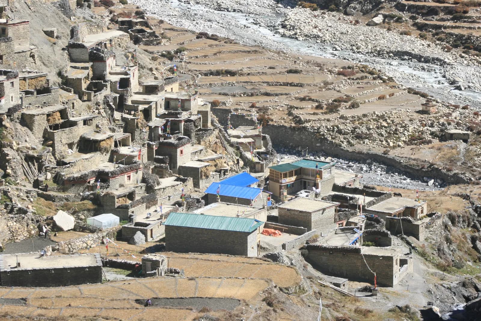
फ़ोटो: Sharadgurung7711 · CC BY-SA 4.0
अंग्रेज़ी में दिखाया गया — अभी अनुवाद नहीं हुआ।
यह यात्रा-कार्यक्रम ड्राफ़्ट है और अभी सत्यापित नहीं हुआ है। चरणों की पुष्टि हमेशा अपने गाइड से करें।
Written by FindTrekkingPartner teamFindTrekkingPartner team द्वारा समीक्षितहम समीक्षा कैसे करते हैंFindTrekkingPartner
Nar Phu Valley Trek नेपाल के Annapurna क्षेत्र में 11 दिन का ट्रेक है, जो 5,306 मीटर तक चढ़ता है। विदेशी ट्रेकर FindTrekkingPartner पर अपनी तारीखों, बजट और रफ़्तार के साथ ट्रिप पोस्ट करके इसके लिए पार्टनर खोज सकते हैं। मैच तब तक निजी रहते हैं जब तक दोनों ट्रेकर सहमत न हों, और सेवा मुफ़्त है। मध्यम दरों पर लाइसेंस प्राप्त गाइड का खर्च चार ट्रेकर के साझा करने पर 11 दिनों में प्रति व्यक्ति लगभग USD 69 है, जबकि अकेले एक ट्रेकर के लिए USD 275। सबसे अच्छे मौसम Mar–May, Oct–Nov हैं। यहां व्यवहार में लाइसेंस प्राप्त गाइड ज़रूरी है: 2026 के ऑपरेटरों के अनुसार नेपाल पर्यटन बोर्ड का अप्रैल 2023 का नियम राष्ट्रीय उद्यानों और संरक्षण क्षेत्रों की चौकियों पर लागू किया जाता है, जिसमें लांगटांग सबसे सख़्त है और अन्नपूर्णा भी जांच करता है (19 अक्टूबर 2026 को जांचा गया)। पंजीकृत एजेंसी के माध्यम से गाइड रखें और उनसे पुष्टि करें। अंतिम सत्यापन: 21 अक्टूबर 2026। स्रोत: नेपाल पर्यटन बोर्ड, DNPWC, आव्रजन विभाग।
स्रोत:Department of Immigration, NepalNepal Tourism BoardDepartment of National Parks and Wildlife Conservation
Nar Phu Valley Trek के लिए पार्टनर खोजें
- Nar Phu Valley Trek के लिए पार्टनर खोजेंअभी कोई खुली ट्रिप नहीं
- Annapurna Base Camp Trek के लिए पार्टनर खोजें23 खुली ट्रिप
- Annapurna Circuit Trek के लिए पार्टनर खोजें4 खुली ट्रिप
- Poon Hill Trek (Ghorepani) के लिए पार्टनर खोजें3 खुली ट्रिप
- Tilicho Lake Trek के लिए पार्टनर खोजें4 खुली ट्रिप
- Mardi Himal Trek के लिए पार्टनर खोजें27 खुली ट्रिप
परिचय
Kathmandu से शुरूदर्रे: Kang La11 दिन · अधिकतम 5,306 मी
सबसे अच्छा मौसम: Sep–Nov, Mar–May · परमिट: Nar Phu restricted area permit (Department of Immigration, via a registered agency), Annapurna Conservation Area entry permit, TIMS card where required
The Nar Phu Valley trek is an 11-day loop through a remote restricted valley on the north side of the Annapurna range, in Manang District. It drives from Kathmandu to Besisahar and on to Koto, climbs through the Nar Phu gorge to Meta, Kyang and Phu, crosses to Nar, and returns over the Kang La at about 5,306 m to Ngawal and Manang, before the drive back. The route covers about 82 km on foot with large daily climbs and a gain of about 7,000 m according to the elevation model, so it is a hard trek. The valley is a restricted area inside the Annapurna Conservation Area, so you need a Restricted Area Permit through a registered agency, the conservation area permit and a licensed guide. The best months are September to November, and March to May. It suits fit trekkers who want Tibetan culture and a quiet valley and can handle a high pass.
What the trek is like
The trail leaves the Marsyangdi valley at Koto and enters a steep gorge of cliffs and pine forest, crossing bridges high above the Nar Phu Khola. After Meta the valley opens, and the villages of Kyang and Phu appear, with stone houses, chortens and fields at about 4,100 m. Phu has an old monastery and a view of Himlung Himal. The trail then crosses to Nar, a larger village with a gompa, and climbs to the Kang La, from which views of the Annapurna range open. The descent to Ngawal reaches the main Annapurna Circuit trail, and the last day follows it to Manang.
Highlights
- Phu village and Phu Gompa, with old Tibetan-style houses and chortens
- Nar village and its monastery
- The Nar Phu gorge, a deep, narrow canyon of cliffs and waterfalls
- The Kang La, with views of Annapurna II, Annapurna IV and Gangapurna
- Blue sheep, and possible snow leopard signs on the high slopes
Permits and rules
The Nar Phu valley is a restricted area. You need a Restricted Area Permit from the Department of Immigration, issued through a registered agency, an Annapurna Conservation Area entry permit and a TIMS card where required. A licensed guide must accompany you. Reports of a March 2026 notice say individual foreigners may apply, but the permit still needs an agency and a guide. Fees and day counts have changed more than once, so ask the agency for the current amounts and check them with the Department of Immigration. Carry several copies of your passport and permits for check posts.
Best season
September to November have the clearest weather, and March to May are possible, but the Kang La may hold snow in early spring. The monsoon is wetter on the south side and quieter in this rain-shadow valley, but landslides can block the road. Winter is very cold, with heavy snow on the pass.
Altitude
The plan sleeps at Meta (about 3,560 m), Phu (about 4,080 m, with a rest day) and Nar (about 4,110 m, with a rest day), before the Kang La at about 5,306 m. The pass day gains about 1,100 m and descends about 1,600 m, so it is long and tiring. Watch for headache, nausea and poor sleep, never ascend with symptoms, and descend if they worsen. Discuss altitude medicine with your doctor.
Getting there and away
Drive from Kathmandu to Besisahar (6 to 7 hours) and continue by jeep along the Marsyangdi road to Koto, about 6 to 7 hours more. The return from Manang to Besisahar by jeep takes 8 to 9 hours on a rough road, followed by the drive to Kathmandu. Landslides can cause delays, so keep a spare day.
Lodges, food and costs
Simple lodges and homestays operate in Meta, Kyang, Phu and Nar, with dal bhat, noodles, tsampa and tea. Facilities are basic, and some agencies carry tents and a cook for flexibility. Prices rise with altitude, and you should bring cash for the whole trek, because there are no machines beyond Besisahar and Manang.
Packing list
Broken-in boots, waterproof layers, a down jacket, a sleeping bag rated to about minus 15 C, gloves, hat, sunglasses, sun cream, gaiters, trekking poles, a headlamp, water purification and a first-aid kit. A pair of microspikes can help on the Kang La if snow lies.
Who this trek suits and how to prepare
The trek suits fit trekkers who like culture and remote valleys and are comfortable with long days at altitude. Prepare with hill walks, stair training and some days with a loaded pack. The pass day of about 15 km needs good stamina.
The plan at a glance
Days 1 and 2 drive to Besisahar and Koto. Days 3 and 4 walk to Meta and Phu, with a rest day on day 5. Day 6 walks to Nar and day 7 is a rest day. Day 8 crosses the Kang La to Ngawal and day 9 walks to Manang. Days 10 and 11 drive to Besisahar and Kathmandu.
Extensions
From Manang you can continue over the Thorong La to Muktinath and Jomsom on the Annapurna Circuit, which adds about a week. Others add a side trip to Tilicho Lake or a day at Manang, or combine the trek with a short stay in Pokhara.
Practical tips from the trail
- Walking times in the day plan are estimates from distance and climb, checked against operator itineraries; real times differ with pace, load and weather.
- Start early on the Kang La day, with food, water and warm layers.
- Check the snow with your guide before leaving Nar.
- Keep a spare day for the Marsyangdi road.
- Respect monasteries and walk clockwise around chortens.
- Carry cash in small notes, as villages have no machines.
Responsible trekking
Take rubbish out, use filtered water, buy from local families and respect the valley's customs. Do not give sweets or money to children.
मुख्य आकर्षण
- Phu and Nar, Tibetan-style villages at about 4,100 m in a restricted valley
- The Nar Phu gorge, with cliffs, suspension bridges and waterfalls
- The Kang La at about 5,306 m, with views of the Annapurna range
- Phu Gompa and old stone houses and chortens
- A quiet, remote alternative to the Annapurna Circuit
रूट मैप
रूट डेटा OpenStreetMap से है, हमारी टीम ने अभी जाँचा नहीं है। इसे प्लानिंग के लिए इस्तेमाल करें, नेविगेशन के लिए नहीं।
दिन-ब-दिन
आप पिछली रात से 1,840 मी ऊँचाई पर सोएँगे, जो 500 मी की सामान्य सीमा से ज़्यादा है। धीरे चलें, खूब पानी पिएँ और सिरदर्द या मतली पर नज़र रखें।
Continue by jeep from Besisahar up the Marsyangdi valley to Koto at about 2,600 m, about 6 to 7 hours on a rough road, passing Syange, Tal, Dharapani and Chame as the scenery turns from subtropical to alpine. Koto is a small village near the junction of the Nar Phu Khola and the entrance to the restricted valley, with a checkpost where your permits are inspected. Spend the afternoon resting and preparing, because the trail begins tomorrow. The air is cool. Keep a warm layer handy because the valley is cooler than Besisahar.
आप पिछली रात से 960 मी ऊँचाई पर सोएँगे, जो 500 मी की सामान्य सीमा से ज़्यादा है। धीरे चलें, खूब पानी पिएँ और सिरदर्द या मतली पर नज़र रखें।
A long first walking day from Koto to Meta at about 3,560 m, about 16 km, taking 8 to 9 hours. The trail enters the Nar Phu gorge, climbing and dropping along cliffs above the river on narrow paths and bridges, with pine forest and waterfalls. The elevation model shows large ups and downs in the gorge. Carry lunch and water, and keep a steady pace. Meta is a small village of stone houses where you spend the night. Drink water regularly and avoid walking directly under loose rock.
आप पिछली रात से 520 मी ऊँचाई पर सोएँगे, जो 500 मी की सामान्य सीमा से ज़्यादा है। धीरे चलें, खूब पानी पिएँ और सिरदर्द या मतली पर नज़र रखें।
Walk from Meta to Phu at about 4,080 m via Kyang, about 18 km with a climb of 1,200 m, taking 7 to 8 hours. The valley opens as you leave the forest, with views of cliffs, chortens and the first Tibetan-style stone houses. Kyang is a seasonal herders' settlement, and Phu is a village on a terrace with an old monastery and a view of Himlung Himal. Watch for symptoms of altitude sickness, drink plenty of water and rest early. Pace yourself, because the altitude is the highest of the trek so far.
A rest and acclimatisation day at Phu. Visit Phu Gompa and walk through the village's lanes of stone houses and chortens, taking an easy hike up the valley toward the Himlung Himal base camp trail, returning by the afternoon. The aim is to sleep at the same height as the day before, and to let your body adapt. Respect the monastery, ask before taking photographs and walk clockwise around the chortens. Rest, eat well and drink water. Use the quiet day to dry gear and check your pass plan.
Walk from Phu to Nar at about 4,110 m, about 21 km with 1,400 m of climbing and 1,270 m of descent, taking 8 to 10 hours. The trail follows the valley back to the junction below Phu, then climbs on a high path to Nar, a larger village with a gompa and stone houses. It is a long day, so carry lunch and water, and keep a steady pace. The views of cliffs and peaks are fine, and Nar's lodges are welcome after the long walk.
A rest day at Nar. Walk through the village and visit the gompa, then take an easy hike up the slopes toward the Kang La base for views of the valley and the Annapurna range, returning by the afternoon. The aim is to rest and let your body adapt before the pass. Check your gear, charge power banks if the lodge has solar power and talk to your guide about the weather and snow on the Kang La. Eat well and drink water.
The pass day. From Nar climb to the Kang La at about 5,306 m and descend to Ngawal at about 3,660 m, about 15 km with 1,100 m of climbing and 1,630 m of descent, taking 6 to 8 hours or more. Start before dawn, carry lunch, water and warm layers, and move steadily. The pass has views of Annapurna II, Annapurna IV and Gangapurna, and the descent is steep and long. Ngawal sits on the main Annapurna trail. Rest and eat well.
A short walk from Ngawal to Manang at about 3,540 m via Humde, about 12 km, taking 3.5 to 5 hours. The route joins the Annapurna Circuit trail, passing Humde and the airstrip, with views of the Annapurna range and Gangapurna Lake. Manang is a busy village with bakeries, shops, a Himalayan Rescue Association aid post and lodges. Use the afternoon to rest, shower, wash clothes and enjoy a bakery treat. You may meet Annapurna Circuit trekkers. Keep your passport and permit copies in your hand luggage.
Drive from Manang to Besisahar, about 8 to 9 hours by jeep on a rough road down the Marsyangdi valley, passing Chame, Dharapani and Syange. The scenery changes from alpine to subtropical as you descend. Leave early and carry water and snacks, because the road can be slow in places and landslides can cause delays. Besisahar has hotels, hot showers and restaurants, a welcome change after the trek. Rest and celebrate your crossing. Keep a warm layer for the cooler early morning start.
आप पिछली रात से 640 मी ऊँचाई पर सोएँगे, जो 500 मी की सामान्य सीमा से ज़्यादा है। धीरे चलें, खूब पानी पिएँ और सिरदर्द या मतली पर नज़र रखें।
Drive from Besisahar to Kathmandu, about 6 to 7 hours along the Marsyangdi valley and the Prithvi Highway. Leave early to arrive in the afternoon, and keep a spare day in the schedule in case landslides block the road. Back in the hotel, shower, repack and celebrate with a good dinner. Tip your guide and porters according to your agency's guidelines, and enjoy the memory of a trek through one of Nepal's most remote and culturally rich valleys. Keep your passport and permit copies in your hand luggage.
अनुकूलन
रात-दर-रात सोने की ऊँचाई। लाल बार पिछली रात से 500 मी से ज़्यादा चढ़ाई दिखाते हैं; आराम के दिन चिह्नित हैं।
- सोने की ऊँचाई
- 500 मी से ज़्यादा बढ़ोतरी
- आराम का दिन
कितना खर्च होता है
प्रति व्यक्ति कुल अनुमानित खर्च: ऊँचाई के हिसाब से लॉज और खाना, परिवहन, परमिट, और गाइड व पोर्टर। जितने ज़्यादा ट्रेकर्स गाइड और पोर्टर साझा करते हैं, हर व्यक्ति उतना कम देता है। अक्टूबर 2026 तक।
| स्टाइल | 1 ट्रेकर | 2 ट्रेकर साथ में | 4 ट्रेकर साथ में |
|---|---|---|---|
| किफ़ायती | $650–$900* | $540–$740* | $490–$660* |
| मध्यम बजट | $1,100–$1,600* | $790–$1,100* | $650–$910* |
| आरामदायक | $1,150–$1,700* | $920–$1,300* | $790–$1,100* |
गाइड साझा करें, पैसे बचाएँ
मध्यम श्रेणी में अकेला ट्रेकर लगभग $1,100–$1,600 देता है; एक गाइड और दो पोर्टर साझा करने वाले चार ट्रेकर्स हर एक लगभग $650–$910 देते हैं (ऊपरी सीमा पर 42% कम)।
साथ में 2 ट्रेकर्स के लिए ब्योरा
| मद | किफ़ायती | मध्यम बजट | आरामदायक |
|---|---|---|---|
| लॉज और खाना | $280–$380 | $340–$480 | $420–$580 |
| परिवहन | $10–$50 | $140–$230 | $140–$230 |
| परमिट | $120–$160 | $120–$160 | $120–$160 |
| गाइड | $110–$170 | $110–$170 | $110–$170 |
| पोर्टर | — | $50–$90 | $100–$180 |
बजट में सार्वजनिक परिवहन है और पोर्टर नहीं; मध्यम में दो ट्रेकर्स के बीच एक पोर्टर और निजी वाहन है; आरामदायक में हर ट्रेकर को एक पोर्टर मिलता है। जहाँ गाइड ज़रूरी है या स्टाइल मध्यम या आरामदायक है, वहाँ गाइड शामिल है।
प्रति रात लॉज और खाना (कमरा और एक दाल भात)
2 रातें Below 2,500 m: कमरा $2–$6, दाल भात $4–$7 · 4 रातें 2,500 to 3,800 m: कमरा $4–$9, दाल भात $5–$9 · 4 रातें Above 3,800 m: कमरा $10–$15, दाल भात $10–$12
परमिट शुल्क (आधिकारिक स्रोत)
शामिल नहीं
इनके लिए कोई प्रकाशित कीमत नहीं मिली: Besisahar to Koto and Manang to Besisahar jeeps। * से चिह्नित कुल में ये शामिल नहीं हैं; अपनी एजेंसी से पूछें।
खर्च के स्रोत
- PriceNepal: Nepal Travel Cost Guide 2026 (2026-05-14)
- Third Rock Adventures: Nepal trek budget planner (2026-05-09)
- Himalayan Partner: Guide and porter price in Nepal 2026 (2026-02-10)
- Shikhar Adventure: Annapurna Circuit trek cost (2026-02-03)
ऑपरेटर गाइड से अनुमान, कोटेशन नहीं। टिप, बीमा, गियर और काठमांडू के होटल शामिल नहीं हैं; USD प्लेटफ़ॉर्म की विनिमय दर पर।
फ़ोटो
अक्सर पूछे जाने वाले सवाल
Yes, a Restricted Area Permit from the Department of Immigration through a registered agency, plus the Annapurna Conservation Area permit and a TIMS card where required. Ask for current fees.
No. A licensed guide is compulsory in the restricted area. Reports say that since March 2026 individuals may apply for the permit, but a registered agency and guide are still required.
Eleven days from Kathmandu on this plan, including two driving days at each end, two rest days and the Kang La crossing. Many agencies allow 12 to 14 days.
About 5,306 m, according to OpenStreetMap. Guides often quote 5,320 m.
September to November, and March to May. The Kang La can hold snow in early spring, and winter is very cold.
Yes. From Manang you can continue over the Thorong La, which adds about a week and needs the ACAP permit, which you already hold.
Hard. The gorge trail has steep ups and downs, the days are long, and the Kang La is a high pass above 5,300 m.
स्रोत
- Nar Phu Valley Trek, 10 days (Himalayan Local Guide)
- Nar Phu Valley Trek itinerary (Trekking in Nepal)
- Annapurna Conservation Area (Wikipedia)
- Manang District (Wikipedia)
- Department of Immigration, Nepal
- Restrictions on trekking for foreigners in controlled areas of 13 districts (Kantipur, 6 May 2026)
- Nepal Tourism Board
- Himalayan Rescue Association
- OpenStreetMap (elevation tags of passes, villages and peaks)
ट्रेल के किनारे
रूट के हर दिन ठहरने की जगहें, चिकित्सा सहायता, पानी और देखने लायक जगहें।
1. Kathmandu → Besisahar
- त्रिभुवन अन्तर्राष्ट्रीय विमानक्षेत्र · हवाई अड्डे और परिवहन · 1,340 मी
2. Besisahar → Koto
इस दिन के लिए अभी कुछ मैप नहीं हुआ है।इस दिन के लिए अभी कुछ मैप नहीं हुआ है।3. Koto → Meta
- Drinking Water · ज़रूरी सुविधाएँ · 2,891 मी
- Chomcho Gufa Hotel · ठहरने की जगहें · 3,190 मी
- Mayta Guest House and restaraunt · ठहरने की जगहें · 3,621 मी
- Hotel Narpa · ठहरने की जगहें · 3,640 मी
- TERELHA Guest House & Restaurant · ठहरने की जगहें · 3,626 मी
Show all 6 places
- Drinking Water · ज़रूरी सुविधाएँ · 2,891 मी
- Chomcho Gufa Hotel · ठहरने की जगहें · 3,190 मी
- Himalayan Yak Hotel &Restaurant · ठहरने की जगहें · 3,466 मी
- Mayta Guest House and restaraunt · ठहरने की जगहें · 3,621 मी
- Hotel Narpa · ठहरने की जगहें · 3,640 मी
- TERELHA Guest House & Restaurant · ठहरने की जगहें · 3,626 मी
4. Meta → Phu
- Zambala Guest House Restaurant · ठहरने की जगहें · 3,611 मी
- Buddha Guest House & Restaurant · ठहरने की जगहें · 3,785 मी
- Hôtel Lama · ठहरने की जगहें · 4,021 मी
- Viewpoint · व्यूपॉइंट · 4,095 मी
- Karsang Lodge · ठहरने की जगहें · 4,066 मी
Show all 9 places
- Zambala Guest House Restaurant · ठहरने की जगहें · 3,611 मी
- Buddha Guest House & Restaurant · ठहरने की जगहें · 3,785 मी
- Dikey Restaurant · ठहरने की जगहें · 3,802 मी
- Karma hotel · ठहरने की जगहें · 3,814 मी
- Chyakhu Guest House e Restaurant · ठहरने की जगहें · 3,817 मी
- Hotel · ठहरने की जगहें · 3,875 मी
- Hôtel Lama · ठहरने की जगहें · 4,021 मी
- Viewpoint · व्यूपॉइंट · 4,095 मी
- Karsang Lodge · ठहरने की जगहें · 4,066 मी
5. Phu
इस दिन के लिए अभी कुछ मैप नहीं हुआ है।इस दिन के लिए अभी कुछ मैप नहीं हुआ है।6. Phu → Nar
- Phu Mountain Lodge · ठहरने की जगहें · 4,063 मी
- Shanti Hotel & Restaurant · ठहरने की जगहें · 4,219 मी
- Laxmi Hotel · ठहरने की जगहें · 4,204 मी
- Diki Ling Hotel · ठहरने की जगहें · 4,210 मी
Show all 8 places
- Phu Mountain Lodge · ठहरने की जगहें · 4,063 मी
- Tashi Delek Hotel · ठहरने की जगहें · 3,873 मी
- Chyakhu Guest House · ठहरने की जगहें · 3,799 मी
- Monastery · ठहरने की जगहें · 3,547 मी
- Gulung Teahouse · ठहरने की जगहें · 3,870 मी
- Shanti Hotel & Restaurant · ठहरने की जगहें · 4,219 मी
- Laxmi Hotel · ठहरने की जगहें · 4,204 मी
- Diki Ling Hotel · ठहरने की जगहें · 4,210 मी
7. Nar
इस दिन के लिए अभी कुछ मैप नहीं हुआ है।इस दिन के लिए अभी कुछ मैप नहीं हुआ है।8. Nar → Ngawal
- Drinking Water · ज़रूरी सुविधाएँ · 4,364 मी
- Shanti Hotel · ठहरने की जगहें · 3,675 मी
- Ngawal · ठहरने की जगहें · 3,673 मी
- Tibet Guest House & Restaurant · ठहरने की जगहें · 3,671 मी
9. Ngawal → Manang
- ACAP Safe Drinking Water Station · ज़रूरी सुविधाएँ · 3,394 मी
- Hotel Mountain Lake · ठहरने की जगहें · 3,537 मी
- HRA Manang Aid Post · चिकित्सा · 3,540 मी
- Tilicho Hotel & Restaurant · ठहरने की जगहें · 3,538 मी
- Safe Drinking Water Station · ज़रूरी सुविधाएँ · 3,550 मी
- Hotel Marsyangdi · ठहरने की जगहें · 3,545 मी
- Moon Light Hotel & Restaurant · ठहरने की जगहें · 3,550 मी
- Manang Health Post · चिकित्सा · 3,558 मी
Show all 27 places
- Buddha Kitchen Hotel · ठहरने की जगहें · 3,658 मी
- Royal Nyeshyang · ठहरने की जगहें · 3,655 मी
- Manang Airport · हवाई अड्डे और परिवहन · 3,353 मी
- ACAP Safe Drinking Water Station · ज़रूरी सुविधाएँ · 3,394 मी
- Shanta Hotel · ठहरने की जगहें · 3,396 मी
- Viewpoint · व्यूपॉइंट · 3,454 मी
- Small lake · प्रकृति · 3,437 मी
- Munji Lodge & Bakery · ठहरने की जगहें · 3,470 मी
- Munji lodge · ठहरने की जगहें · 3,471 मी
- Hotel New Yak · ठहरने की जगहें · 3,472 मी
- Hotel Buddha & peace cafe · ठहरने की जगहें · 3,473 मी
- Himalayan lodge · ठहरने की जगहें · 3,474 मी
- Namaste trekkers homestay · ठहरने की जगहें · 3,485 मी
- Hotel Mountain Lake · ठहरने की जगहें · 3,537 मी
- HRA Manang Aid Post · चिकित्सा · 3,540 मी
- Tilicho Hotel & Restaurant · ठहरने की जगहें · 3,538 मी
- Safe Drinking Water Station · ज़रूरी सुविधाएँ · 3,550 मी
- Hotel Marsyangdi · ठहरने की जगहें · 3,545 मी
- Moon Light Hotel & Restaurant · ठहरने की जगहें · 3,550 मी
- Yak Hotel · ठहरने की जगहें · 3,544 मी
- Moon Light hotel · ठहरने की जगहें · 3,550 मी
- Alpine home · ठहरने की जगहें · 3,544 मी
- Hotel North Pole · ठहरने की जगहें · 3,550 मी
- Gangapurna Hotel Lodge · ठहरने की जगहें · 3,543 मी
- Manang Health Post · चिकित्सा · 3,558 मी
- Ghyalchan & Sister · ठहरने की जगहें · 3,543 मी
- Ghale guest house · ठहरने की जगहें · 3,544 मी
10. Manang → Besisahar
इस दिन के लिए अभी कुछ मैप नहीं हुआ है।इस दिन के लिए अभी कुछ मैप नहीं हुआ है।11. Besisahar → Kathmandu
इस दिन के लिए अभी कुछ मैप नहीं हुआ है।इस दिन के लिए अभी कुछ मैप नहीं हुआ है।
अंतिम बार 21 अक्टू॰ 2026 को सत्यापितपुरानी जानकारी की रिपोर्ट करें