

Drive from Kathmandu to Machha Khola, at 870 m, a jeep journey of eight to nine hours via Dhading, Arughat and Soti Khola on a rough and dusty road. The route follows the Budhi Gandaki river and the last stretch is a narrow track cut into the hillside. Landslides can cause delays in the monsoon. Machha Khola is a small village of lodges beside the river, at the start of the trail. Check your gear and permits, and rest. Tomorrow is the first full day of walking along the Budhi Gandaki gorge.
Manaslu Circuit Trek
A restricted-area circuit around Manaslu over the Larkya La, exiting via Dharapani into the Annapurna region.
- 天數14
- 最高海拔5,106 公尺
- 距離137 公里
- 爬升9,203 公尺
- 難度困難
- 最佳月份Mar–May, Oct–Nov
- 許可4
照片:Nabin K. Sapkota · CC BY-SA 4.0
以英文顯示——尚未翻譯。
Written by FindTrekkingPartner team審閱者:FindTrekkingPartner team我們如何審閱FindTrekkingPartner
Manaslu Circuit Trek是位於尼泊爾Manaslu地區的 14 天健行路線,最高海拔達 5,106 公尺。外國健行者可以在 FindTrekkingPartner 發布行程,填入日期、預算與步調,為這條路線尋找夥伴。在雙方健行者都同意之前,配對結果會保持私密,且服務完全免費。 以中等價位計算,四位健行者共用時,持照嚮導 14 天的費用約為每人 106 美元(USD),一人獨自健行則為 423 美元(USD)。最佳季節為Mar–May, Oct–Nov。 這裡是受限地區,因此透過登記代理商聘請持照嚮導是許可證的一部分,整個團隊須使用同一份代理商許可證一起行動。 這條路線的開放行程列於下方,附有出發月份、團隊人數與剩餘名額。 最後查證日期:2026年10月19日。資料來源:尼泊爾旅遊局(Nepal Tourism Board)、DNPWC、移民局。
資料來源:Department of Immigration, NepalNepal Tourism BoardDepartment of National Parks and Wildlife Conservation
尋找Manaslu Circuit Trek的夥伴
- 尋找Manaslu Circuit Trek的夥伴4 個開放行程
- 尋找Tsum Valley Trek的夥伴目前尚無開放行程
概覽
從 Kathmandu 出發埡口:Larkya La14 天 · 最高 5,106 公尺
最佳季節:Mar–May, Oct–Nov · 許可:Restricted Area Permit (Department of Immigration, via a registered agency), Manaslu Conservation Area permit, Annapurna Conservation Area permit, TIMS card where required
The Manaslu Circuit follows the Budhi Gandaki river north from Machha Khola through Jagat, Deng, Namrung and Lho to Samagaun, climbs to Samdo and Dharamsala, crosses the Larkya La at 5,106 m, and descends to Bimthang and Tilije before meeting the Annapurna Circuit at Dharapani. This 14-day plan starts with a jeep ride from Kathmandu and ends with a drive from Besisahar. The route lies in a restricted area, so it requires a permit from the Department of Immigration and a licensed guide, and it is far quieter than the Annapurna or Everest trails. Lodges are simpler, days are long and the pass is a serious crossing. In return you see Manaslu from several angles and cultures that are almost entirely Tibetan in the upper valley. It suits experienced trekkers who accept long days and basic lodges, and who will book through a registered agency for the restricted-area permit and guide.
What the trek is like
The first three days follow the Budhi Gandaki gorge, with suspension bridges, landslide scars and subtropical forest. Above Deng the valley turns north and the first Tibetan-style villages appear, with mani walls, chortens and monasteries; Namrung and Lho have fine gompas. Beyond Lho the valley opens to Samagaun and the view of Manaslu, which fills the horizon. Samdo is a high trading village close to the Tibetan border. From Dharamsala the Larkya La climb is on moraine and snow, with an icy descent into Bimthang, a broad valley with views of Manaslu's western face.
Highlights
- The Budhi Gandaki gorge and its suspension bridges
- Lho, Samagaun and the view of Manaslu
- Pungyen Gompa and Birendra Lake on rest days
- Samdo, a Tibetan trading village near the border
- Larkya La at 5,106 m and the descent to Bimthang
Permits and rules
You need a Restricted Area Permit (RAP) from the Department of Immigration, Manaslu Conservation Area and Annapurna Conservation Area permits, and a TIMS card where required, all arranged by a registered agency. A licensed guide must accompany you at all times. Since 22 March 2026 one trekker can apply, so a group of two is no longer needed; the agency and guide requirement remains, and a partner halves the guide cost. Check current permit costs and rules with the agency or the Department of Immigration.
Best season
October and November have the most stable weather, and March to May is also good. The pass is usually clear in May and in October to early November. Avoid the monsoon and winter, when snow on Larkya La makes crossing hazardous.
Acclimatisation
The plan includes two rest days: one at Samagaun and one at Samdo. Use them for day hikes to Pungyen Gompa, Birendra Lake or toward Manaslu Base Camp, and sleep low. Sleep at Dharamsala before the pass. If anyone has symptoms of altitude sickness, descend or rest. A spare day before the pass is helpful if the weather is poor.
The pass day
The crossing begins before dawn from Dharamsala (about 4,470 m), climbs on moraine and snow to Larkya La, and descends steeply to Bimthang (about 3,720 m). It takes eight to ten hours. The top is cold and windy, with views of Manaslu, Himlung Himal and Cho Danda. Carry warm gloves, goggles and microspikes, and keep your group together.
Getting there and away
Jeep from Kathmandu to Machha Khola takes 8 to 9 hours on a rough road. After the trek, a jeep from Tilije or Dharapani takes you to Besisahar, and from there it is 6 to 7 hours to Kathmandu.
Lodges, food and costs
Lodges are simple, with limited menus above Namrung. Rooms are cheap if you eat at the lodge, and prices rise with remoteness. Carry cash and snacks.
Packing list
Waterproof boots, warm layers, down jacket, insulated gloves, hat, sunglasses or goggles, microspikes, a sleeping bag rated to about -15 C, trekking poles, headlamp, water purification and a first-aid kit.
Who this trek suits and how to prepare
The circuit suits experienced trekkers who are comfortable with long days, basic lodges and a high pass. Prepare for three months with long hill walks, stair climbing and, if possible, a previous high-altitude trek. Practise using microspikes and trekking poles. Mental preparation matters: remote conditions, cold nights and a long pass day can be tiring.
The plan at a glance
Day 1 drives to Machha Khola (870 m), and days 2 to 6 follow the Budhi Gandaki through Jagat, Deng, Namrung and Lho to Samagaun (3,530 m). Day 7 is a rest day with a hike. Day 8 reaches Samdo (3,875 m), and day 9 is a second rest day. Day 10 reaches Dharamsala (4,470 m), and day 11 crosses Larkya La to Bimthang. Day 12 descends to Tilije, day 13 walks to Dharapani and drives to Besisahar, and day 14 drives to Kathmandu.
The restricted-area process
Because the route is a restricted area, your agency applies for the Restricted Area Permit, usually a few days before you travel, and needs your passport, photos and visa. Allow extra time in Kathmandu for the paperwork. Permit checks happen at Jagat, Philim and Samagaun, so carry copies. If the rules change, your agency will update you.
Practical tips from the trail
- Carry spare cash and snacks, because supplies are limited above Namrung.
- Look after your feet on the long days; wear liners and change socks.
- Check the weather and snow on Larkya La with lodge owners and other groups.
- Wear a windproof layer, goggles and gloves on the pass.
- Respect the villagers' customs, and ask before photographing.
Responsible trekking
Carry out all your waste, use purification tablets instead of bottled water and support family-run lodges. Treat your guide and porters well, and avoid disturbing wildlife.
亮點
- Budhi Gandaki gorge
- Lho and Samagaun views of Manaslu
- Pungyen Gompa and Birendra Lake
- Samdo Tibetan trading village
- Larkya La at 5,106 m
路線地圖
路線資料來自 OpenStreetMap,尚未經我們團隊查核。請用於規劃,而非導航。
逐日行程
Follow the Budhi Gandaki upstream, crossing suspension bridges and passing through Khorlabesi, Tatopani, where a hot spring sits beside the river, and Doban. The trail climbs and descends along the gorge, with views of waterfalls and terraced fields. After Doban, the path climbs to Jagat, at 1,340 m, a village with a checkpoint where your Restricted Area Permit is inspected. It is a long day of six to seven hours with ups and downs. Keep your permits and passport handy. Jagat has a number of lodges, and the evening is warm.
你今晚的過夜海拔比前一晚高 520 公尺,超過一般 500 公尺的準則。請放慢速度、多喝水,並留意是否頭痛或噁心。
Climb out of Jagat through Salleri and Sirdibas to Philim, a large Gurung village with views of the valley, where the trail to the Tsum Valley branches off. Continue through bamboo forest and along the gorge to Deng, at 1,860 m, crossing the river several times on suspension bridges. It is a six- to seven-hour day with a steady climb. The valley narrows, and landslides sometimes affect the trail. Deng is a small settlement with a few lodges. Drink plenty of water and rest. The culture begins to change from Gurung to Tibetan here.
你今晚的過夜海拔比前一晚高 770 公尺,超過一般 500 公尺的準則。請放慢速度、多喝水,並留意是否頭痛或噁心。
Cross the river and climb steeply through forest to Bhi and the villages of Ghap and Lihi, where you first see mani walls and chortens in the Tibetan style. Continue along the gorge to Namrung, at 2,630 m, passing through bamboo and rhododendron forest. The trail is a mix of steep climbs and level stretches. Namrung has a checkpoint where your permits are checked, and the village has a small monastery. It is a long day of six to seven hours. The view of the Siringi Himal appears as the valley opens.
你今晚的過夜海拔比前一晚高 540 公尺,超過一般 500 公尺的準則。請放慢速度、多喝水,並留意是否頭痛或噁心。
Climb through forest to Lihi and Sho, a village with views of Manaslu in clear weather, then continue to Lho, at 3,170 m, a large village with a fine monastery above the houses and a view of Manaslu. The path passes through juniper and rhododendron, and the landscape becomes more open. The altitude is now noticeable, so walk slowly and drink water. Lho has several lodges, and the view of Manaslu at sunset is a highlight. It is a short day of four to five hours. Rest and enjoy the evening.
Walk through the village of Shyala, with views of Himalchuli and Ngadi Chuli, and across the open valley to Samagaun, at 3,530 m, the largest village in the upper valley. Samagaun is a Tibetan-influenced village of stone houses with a monastery and views of Manaslu. The altitude is now significant, so rest and drink plenty. In the afternoon, walk to the monastery or around the village. It is a short day of three to four hours, and it prepares you for tomorrow's acclimatisation hike. Samagaun has several lodges.
A rest and acclimatisation day at Samagaun. Choose a hike: climb to Pungyen Gompa, a monastery above the village at about 3,870 m, with views of Manaslu and its glacier, or walk to Birendra Lake, a glacial lake at the foot of the Manaslu glacier. A longer option is to walk toward Manaslu Base Camp, at about 4,800 m, but go only as far as you feel comfortable. Return to sleep at Samagaun. Spend the afternoon resting, washing and eating well. Check your gear for the pass.
Walk from Samagaun through the juniper valley and across a river, along the valley floor to Samdo, at 3,875 m, a Tibetan trading village close to the border. The path is gentle, with views of Manaslu and the Larkya glacier. Samdo has a small monastery and a number of lodges, and the villagers have traded with Tibet for centuries. It is a short day of three to four hours. In the afternoon, walk up the hill behind the village for acclimatisation and views of the valley. Drink water and rest.
A second rest and acclimatisation day, at Samdo. Take a short hike up the ridge toward the Tibetan border or to a viewpoint above the village, then return to sleep. The day gives your body time to adjust before the pass, and it is a good chance to talk with your guide about the weather and conditions on Larkya La. Spend the afternoon resting, drinking and eating. Check your gloves, hat, goggles and microspikes. If anyone is unwell, consider a spare day here.
你今晚的過夜海拔比前一晚高 595 公尺,超過一般 500 公尺的準則。請放慢速度、多喝水,並留意是否頭痛或噁心。
Climb from Samdo across the valley and along the moraine to Dharamsala, also called Larkya Phedi, at about 4,470 m, a stone shelter and a few lodges at the foot of the pass. The path crosses a river and climbs gently, with views of Larkya Peak and the glacier. It is a short day of four hours, but the altitude is high, so walk slowly. Rest, eat and go to bed early; tomorrow starts well before dawn. The lodges are basic and cold. Watch for symptoms of altitude sickness.
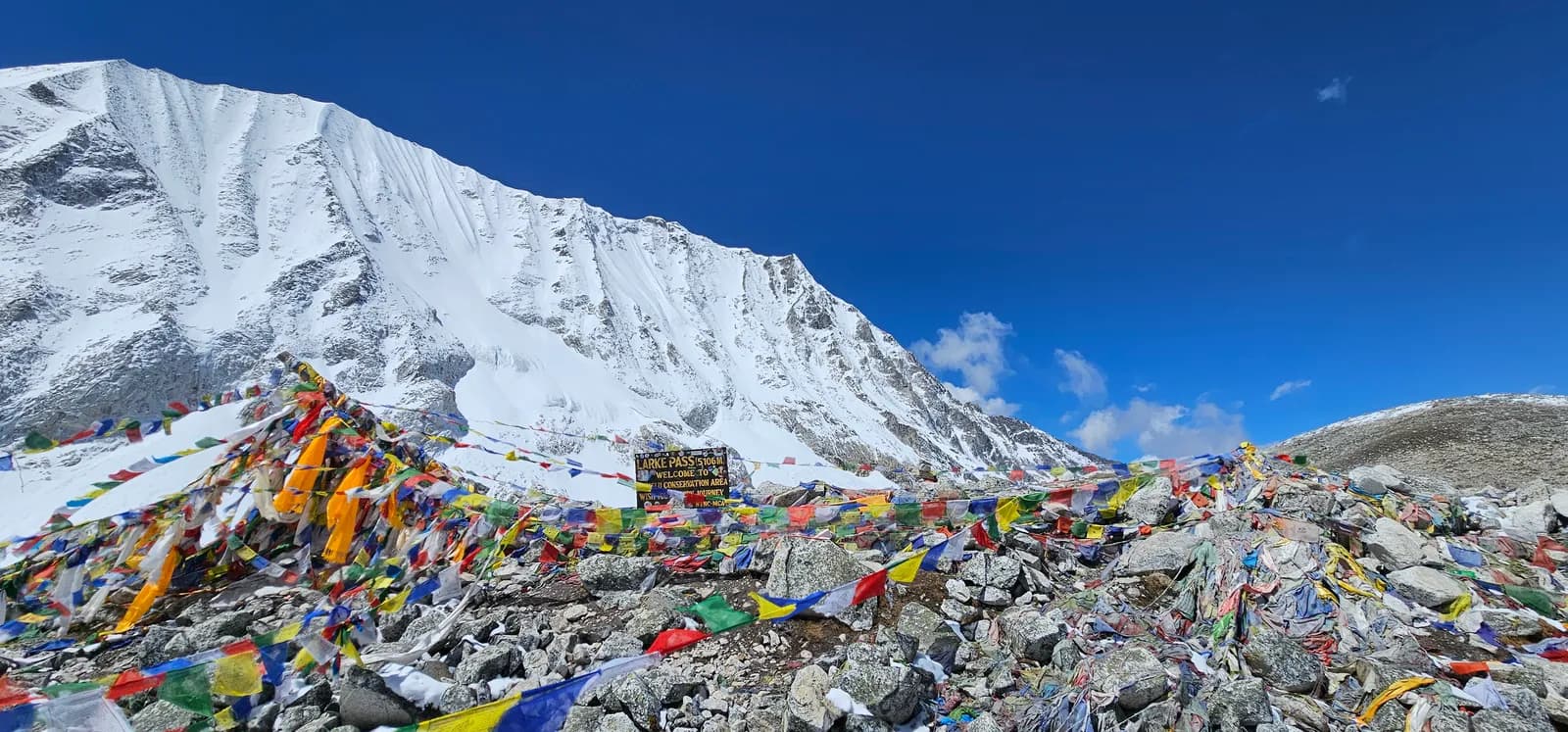
Start before dawn and climb steeply on moraine and snow to the top of Larkya La, at 5,106 m, with prayer flags and views of Manaslu, Himlung Himal and Cho Danda. The climb takes three to four hours, and the top is cold and windy. The descent is steep and icy, with a long moraine slope and a rocky path, to Bimthang, at about 3,720 m, a broad valley with views of Manaslu's western face. It is a very long day of eight to ten hours. Keep your group together and turn back if the weather turns.
Descend from Bimthang through rhododendron and pine forest, passing yak pastures, to Gho and Tilije, at about 2,300 m. The path follows the Dudh Khola and drops steeply through forest, with views of Manaslu behind you. The warmth and the thicker air are welcome after the pass. It is a five- to six-hour day with a steep descent, so use poles. Tilije has a few lodges and the road starts nearby. Rest, wash and eat well. You are now in the Annapurna Conservation Area.
Walk down the valley to Dharapani, at 1,860 m, where the Manaslu trail meets the Annapurna Circuit, a walk of about three hours. From here, a jeep takes you down the Marsyangdi valley to Besisahar, at 760 m, a drive of about three hours on a rough road. Besisahar is a busy town with shops and lodges. Have a hot shower, a good meal and a rest. Pay your guide and porters, and have a farewell dinner. Tomorrow is a long drive to Kathmandu.
你今晚的過夜海拔比前一晚高 640 公尺,超過一般 500 公尺的準則。請放慢速度、多喝水,並留意是否頭痛或噁心。
Drive from Besisahar to Kathmandu, a journey of six to seven hours along the Marsyangdi and Trishuli rivers, on a busy road. Start early to avoid delays. In Kathmandu, shower, repack and reflect on the trek. If you have time, visit Boudhanath or Pashupatinath, or shop in Thamel. Do not schedule an international flight for the same evening, because the road can be slow. Confirm that your permits and passport are in order, and thank your guide and porters for their help.
高度適應
逐夜的過夜海拔。紅色長條表示比前一晚爬升超過 500 公尺;休息日會另外標示。
- 過夜海拔
- 爬升超過 500 公尺
- 休息日
費用
每人的全包估計費用:依海拔計算的旅舍與餐食、交通、許可,以及嚮導與挑夫。分攤嚮導與挑夫的健行者越多,每個人付的就越少。 截至 2026年10月。
| 風格 | 1 位健行者分攤 | 2 位健行者分攤 | 4 位健行者分攤 |
|---|---|---|---|
| 經濟 | US$840–US$1,250 | US$670–US$970 | US$580–US$850 |
| 中等 | US$1,400–US$2,100 | US$1,000–US$1,500 | US$840–US$1,250 |
| 舒適 | US$1,550–US$2,250 | US$1,200–US$1,800 | US$1,050–US$1,550 |
分攤嚮導,省下開銷
以中等價位計算,單獨健行者約需支付 US$1,400–US$2,100;四位健行者分攤一位嚮導和兩位挑夫,每人約 US$840–US$1,250(以價格區間上限計算,少 41%)。
2 位健行者分攤的費用明細
| 項目 | 經濟 | 中等 | 舒適 |
|---|---|---|---|
| 旅舍與餐食 | US$290–US$460 | US$390–US$610 | US$520–US$780 |
| 交通 | US$10–US$40 | US$160–US$230 | US$160–US$230 |
| 許可 | US$180–US$240 | US$180–US$240 | US$180–US$240 |
| 嚮導 | US$170–US$250 | US$170–US$250 | US$170–US$250 |
| 挑夫 | — | US$90–US$160 | US$180–US$310 |
經濟型使用大眾運輸且不請挑夫;中等價位為兩位健行者共用一位挑夫和一輛包車;舒適型則每位健行者各有一位挑夫。在規定需要嚮導,或風格為中等價位或舒適型時,費用已包含嚮導。
每晚旅舍與餐食(房間與一份 dal bhat 餐)
5 晚Below 2,500 m:房間 US$2–US$9,dal bhat US$4–US$7 · 5 晚2,500 to 3,800 m:房間 US$4–US$11,dal bhat US$5–US$11 · 3 晚Above 3,800 m:房間 US$7–US$19,dal bhat US$8–US$13
許可費用(官方來源)
費用來源
- PriceNepal: Nepal Travel Cost Guide 2026 (2026-05-14)
- Third Rock Adventures: Nepal trek budget planner (2026-05-09)
- Himalayan Partner: Guide and porter price in Nepal 2026 (2026-02-10)
- Shikhar Adventure: Annapurna Circuit trek cost (2026-02-03)
- Nepal Tourism Board: Trekking Permit (2026-10-18)
估算依據業者指南,並非報價。小費、保險、裝備與加德滿都的飯店不包含;美元依平台匯率計算。
照片
常見問題
Hard. Days are long, lodges are basic and the Larkya La crossing is a serious high-altitude day.
Fourteen days from Kathmandu on this plan, including two rest days.
Yes: a Restricted Area Permit through a registered agency and a licensed guide. Reports say individuals can apply since March 2026; confirm the current rule.
Larkya La is 5,106 m.
October and November, and March to May.
It is not recommended: rain, landslides and cloud affect the lower valley, and the road is often closed.
資料來源
沿途地點
路線每一天沿途的住宿、醫療協助、水源與景點。
1. Kathmandu → Machha Khola
- Tribhuvan International Airport · 機場與交通 · 1,340 公尺
2. Machha Khola → Jagat
- Hot Springs · 自然 · 816 公尺
- Viewpoint of Ganesh Himal & landslide area · 觀景點 · 944 公尺
- Punngpu · 自然 · 1,310 公尺
- Himalayan Tourist Guest House · 住宿 · 1,335 公尺
- Manaslu Shani Hotel & Lodge · 住宿 · 1,353 公尺
- Jagat Guest House · 住宿 · 1,346 公尺
- Rubinala Inn · 住宿 · 1,340 公尺
Show all 22 places
- Hotel Chumvally Restaurant and Lodge · 住宿 · 862 公尺
- Hotel Hilltop · 住宿 · 857 公尺
- Manaslu Hotel & Lodge · 住宿 · 859 公尺
- Hot Springs · 自然 · 816 公尺
- Mt. Everest Hotel · 住宿 · 879 公尺
- Shangri La Hotel · 住宿 · 890 公尺
- Sem Jang Ganesh Hotel · 住宿 · 888 公尺
- River View Guest House · 住宿 · 881 公尺
- Sangri La Hotel · 住宿 · 884 公尺
- Viewpoint of Ganesh Himal & landslide area · 觀景點 · 944 公尺
- 18 Saya Khola Family Guest House · 住宿 · 987 公尺
- Royal Mountain Hotel & Lodge · 住宿 · 984 公尺
- Budhi Gandaki Valley Gusethouse · 住宿 · 983 公尺
- Thulodhunga Hotel and Lodge · 住宿 · 1,146 公尺
- Punngpu · 自然 · 1,310 公尺
- Yaru Guest House · 住宿 · 1,326 公尺
- Hosanna · 住宿 · 1,300 公尺
- Yuru Khola · 住宿 · 1,279 公尺
- Himalayan Tourist Guest House · 住宿 · 1,335 公尺
- Manaslu Shani Hotel & Lodge · 住宿 · 1,353 公尺
- Jagat Guest House · 住宿 · 1,346 公尺
- Rubinala Inn · 住宿 · 1,340 公尺
3. Jagat → Deng
- Jagat Health Unit · 醫療 · 1,335 公尺
- Mongolian cottage · 住宿 · 1,334 公尺
- Shrinki Guest House · 住宿 · 1,336 公尺
- Viewpoint · 觀景點 · 1,978 公尺
- Hotel Windy Valley & Garden · 住宿 · 1,873 公尺
- Namgyal Guest House · 住宿 · 1,884 公尺
Show all 17 places
- Jagat Health Unit · 醫療 · 1,335 公尺
- Mongolian cottage · 住宿 · 1,334 公尺
- Shrinki Guest House · 住宿 · 1,336 公尺
- Royal Guest House · 住宿 · 1,574 公尺
- Philim village and lodge · 住宿 · 1,570 公尺
- Hulchuki hotel and restaurant · 住宿 · 1,564 公尺
- Gorkha view hotel · 住宿 · 1,562 公尺
- Laprak Gurung Bamboo Cottage & Restaurant · 住宿 · 1,633 公尺
- Chum Nubri Ekle Bhatti Chisopi Guest House · 住宿 · 1,633 公尺
- Ekelebhatti Long Bridge Guest House & Restaurant · 住宿 · 1,611 公尺
- Akley Bhatti Hotel & Lodge · 住宿 · 1,620 公尺
- Kham-Sangbo Hotel & Lodge · 住宿 · 1,801 公尺
- Nyak Phedi Guest House · 住宿 · 1,681 公尺
- Viewpoint · 觀景點 · 1,978 公尺
- New Pewa Guest House · 住宿 · 2,002 公尺
- Hotel Windy Valley & Garden · 住宿 · 1,873 公尺
- Namgyal Guest House · 住宿 · 1,884 公尺
4. Deng → Namrung
- Health Post · 醫療 · 2,135 公尺
- Nubri Four Season Resort · 住宿 · 2,616 公尺
- Namrung Tibetan Guest House · 住宿 · 2,604 公尺
- Namrung Guest House · 住宿 · 2,617 公尺
- The River View Cottage · 住宿 · 2,599 公尺
Show all 19 places
- Manaslu Bamboo Hotel · 住宿 · 1,887 公尺
- Shangrila Home · 住宿 · 1,869 公尺
- Karma Hotel · 住宿 · 1,998 公尺
- Hotel Singla Guest house · 住宿 · 2,006 公尺
- Gapkaltal Guest House · 住宿 · 1,984 公尺
- 500 a Night · 住宿 · 1,981 公尺
- Bur Guest House · 住宿 · 2,090 公尺
- The Bur Guest House · 住宿 · 2,090 公尺
- Budhi Gandaki Hotel · 住宿 · 2,109 公尺
- Ghap Cottage Guest House · 住宿 · 2,133 公尺
- Gap Cottage · 住宿 · 2,135 公尺
- Health Post · 醫療 · 2,135 公尺
- Hotel Kyimolung · 住宿 · 2,161 公尺
- Jungle Hotel K.L.S.P · 住宿 · 2,251 公尺
- Organic Apple Farme Guest House · 住宿 · 2,545 公尺
- Nubri Four Season Resort · 住宿 · 2,616 公尺
- Namrung Tibetan Guest House · 住宿 · 2,604 公尺
- Namrung Guest House · 住宿 · 2,617 公尺
- The River View Cottage · 住宿 · 2,599 公尺
5. Namrung → Lho
- Huge waterfall · 自然 · 2,642 公尺
- Lhaptang Guest House · 住宿 · 2,647 公尺
- Himal chuli hotel · 住宿 · 2,825 公尺
- Hotel Sherpa Lodge & Café - Magasin · 住宿 · 2,911 公尺
- Hotel Blue Sky · 住宿 · 3,169 公尺
Show all 11 places
- Huge waterfall · 自然 · 2,642 公尺
- Lhaptang Guest House · 住宿 · 2,647 公尺
- Himal chuli hotel · 住宿 · 2,825 公尺
- Hotel Sherpa Lodge & Café - Magasin · 住宿 · 2,911 公尺
- Tashi Delek Lodge · 住宿 · 2,940 公尺
- Buddhi Gandaki Homestay and Teahouse · 住宿 · 2,998 公尺
- New hotel Himalaya · 住宿 · 2,982 公尺
- Norgyun Hotel · 住宿 · 3,012 公尺
- Zambala Manaslu Sho Guest House · 住宿 · 3,036 公尺
- Hamra Khaja Ghar Hotel · 住宿 · 3,036 公尺
- Hotel Blue Sky · 住宿 · 3,169 公尺
6. Lho → Samagaun
- Hill-top viewpoint towards Manaslu · 觀景點 · 3,328 公尺
- Namasté Guest House · 住宿 · 3,506 公尺
- Yetti · 住宿 · 3,510 公尺
- Shanti Guest House · 住宿 · 3,510 公尺
- The Happiness Guest House · 住宿 · 3,514 公尺
Show all 11 places
- Majestic Manaslu Cottages & Garden · 住宿 · 3,178 公尺
- Tashi Delek Hotel & Lodge · 住宿 · 3,176 公尺
- Lama Guest House · 住宿 · 3,187 公尺
- Lho Norbu Hotel · 住宿 · 3,199 公尺
- Hill-top viewpoint towards Manaslu · 觀景點 · 3,328 公尺
- Namasté Guest House · 住宿 · 3,506 公尺
- Yetti · 住宿 · 3,510 公尺
- Shanti Guest House · 住宿 · 3,510 公尺
- The Happiness Guest House · 住宿 · 3,514 公尺
- Royal Ghorka hotel and sharing idea cafe · 住宿 · 3,515 公尺
- Nubri Shyala Guest House · 住宿 · 3,515 公尺
7. Samagaun
這一天尚未標繪任何地點。這一天尚未標繪任何地點。8. Samagaun → Samdo
- Birendra Lake · 自然 · 3,635 公尺
- Little Tibet · 住宿 · 3,852 公尺
- Cheese Karsay Lodge · 住宿 · 3,854 公尺
- Yak Hotel · 住宿 · 3,845 公尺
- Zambala Hotel · 住宿 · 3,855 公尺
Show all 17 places
- Tashi Delek Hotel · 住宿 · 3,522 公尺
- Samsgaun Hotel & Lodge · 住宿 · 3,528 公尺
- Peace Heaven Hotel & Lodge · 住宿 · 3,529 公尺
- Tashi Yangchen Hotel & Lodge · 住宿 · 3,530 公尺
- Norling · 住宿 · 3,527 公尺
- Mount Manaslu Lodge · 住宿 · 3,530 公尺
- Hotel Base Camp · 住宿 · 3,528 公尺
- Boddhisattva Hotel & Lodge · 住宿 · 3,530 公尺
- Joyful Hotel · 住宿 · 3,532 公尺
- Mandala Hotel · 住宿 · 3,532 公尺
- Birendra Lake · 自然 · 3,635 公尺
- Little Tibet · 住宿 · 3,852 公尺
- Cheese Karsay Lodge · 住宿 · 3,854 公尺
- Yak Hotel · 住宿 · 3,845 公尺
- Zambala Hotel · 住宿 · 3,855 公尺
- New Tashi Deleg · 住宿 · 3,851 公尺
- Hotel SnowLion · 住宿 · 3,851 公尺
9. Samdo
這一天尚未標繪任何地點。這一天尚未標繪任何地點。10. Samdo → Dharamsala
- Larke Bazaar Hotel · 住宿 · 3,920 公尺
- Mt. Manaslu View · 觀景點 · 4,327 公尺
- Larke La Hotel & Lodge · 住宿 · 4,459 公尺
11. Dharamsala → Bimthang
- Viewpoint · 觀景點 · 4,848 公尺
- Drinking Water · 實用資訊 · 4,387 公尺
- Ponkar lake · 自然 · 4,091 公尺
- Hotel Gangar Manaslu & Restaurant · 住宿 · 3,717 公尺
- Ponkar Ganga Hotel · 住宿 · 3,700 公尺
- Sushma Hotel & Restaurant · 住宿 · 3,705 公尺
- Cheers Lilita Hotel & Restaurant · 住宿 · 3,707 公尺
Show all 12 places
- Zambala Hotel · 住宿 · 4,474 公尺
- Peace Lodge · 住宿 · 4,478 公尺
- Viewpoint · 觀景點 · 4,848 公尺
- Drinking Water · 實用資訊 · 4,387 公尺
- Gurungseni Hotel and Restaurant · 住宿 · 4,389 公尺
- 6G Brothers Hotel & Restaurant · 住宿 · 4,387 公尺
- Kusang Hotel & Restaurant · 住宿 · 4,377 公尺
- Ponkar lake · 自然 · 4,091 公尺
- Hotel Gangar Manaslu & Restaurant · 住宿 · 3,717 公尺
- Ponkar Ganga Hotel · 住宿 · 3,700 公尺
- Sushma Hotel & Restaurant · 住宿 · 3,705 公尺
- Cheers Lilita Hotel & Restaurant · 住宿 · 3,707 公尺
12. Bimthang → Tilije
- Small waterfall · 自然 · 2,992 公尺
- The North Face · 住宿 · 2,266 公尺
- Tibetan hotel · 住宿 · 2,274 公尺
- Napa Valley · 住宿 · 2,269 公尺
- Tilche Village Hotel · 住宿 · 2,261 公尺
Show all 13 places
- Purdi Himalayan Seven Sister Hotel · 住宿 · 3,045 公尺
- Himlung Hotel & Restaurant · 住宿 · 3,042 公尺
- Small waterfall · 自然 · 2,992 公尺
- 7 Sisters Guest House · 住宿 · 2,711 公尺
- New Himalayan cottage · 住宿 · 2,703 公尺
- Nirvana Garden · 住宿 · 2,529 公尺
- Larke Peak Guest House & Restaura · 住宿 · 2,527 公尺
- Hotel Super View & Restaurant · 住宿 · 2,514 公尺
- Manaslu hotel · 住宿 · 2,495 公尺
- The North Face · 住宿 · 2,266 公尺
- Tibetan hotel · 住宿 · 2,274 公尺
- Napa Valley · 住宿 · 2,269 公尺
- Tilche Village Hotel · 住宿 · 2,261 公尺
13. Tilije → Besisahar
- Viewpoint · 觀景點 · 1,921 公尺
- Crystal Guest House · 住宿 · 1,825 公尺
- Hayat Guest House · 住宿 · 1,818 公尺
- Hotel Gurkha's Inn & Restaurant · 住宿 · 1,816 公尺
- Manaslu Hotel Restaurant · 住宿 · 1,820 公尺
- Hayenga Waterfall · 自然 · 2,053 公尺
Show all 19 places
- Hotel Tilche · 住宿 · 2,263 公尺
- River view · 住宿 · 2,257 公尺
- Monastery Home stay · 住宿 · 2,203 公尺
- Hotel California · 住宿 · 1,923 公尺
- Viewpoint · 觀景點 · 1,921 公尺
- 3 Sister Guest House · 住宿 · 1,887 公尺
- Kangaroo · 住宿 · 1,882 公尺
- Dafne Hotel · 住宿 · 1,881 公尺
- Kingfisher · 住宿 · 1,874 公尺
- Gyasumda Hotel & Restaurant · 住宿 · 1,877 公尺
- Peaceful Hotel · 住宿 · 1,876 公尺
- Crystal Guest House · 住宿 · 1,825 公尺
- Hayat Guest House · 住宿 · 1,818 公尺
- Hotel Gurkha's Inn & Restaurant · 住宿 · 1,816 公尺
- Manaslu Hotel Restaurant · 住宿 · 1,820 公尺
- Hayenga Waterfall · 自然 · 2,053 公尺
- Tashi Delek Hotel · 住宿 · 1,809 公尺
- Phulbari Hostel & Restaurant · 住宿 · 1,823 公尺
- Manaslu Guest House · 住宿 · 1,813 公尺
14. Besisahar → Kathmandu
這一天尚未標繪任何地點。這一天尚未標繪任何地點。
最後確認於 2026年10月19日回報過時資訊