

Fly from Kathmandu to Nepalgunj, a flight of 45 to 60 minutes south-west to the hot plains of the Terai near the Indian border. Nepalgunj is the hub for far-west flights, and it is often very hot. Transfer to your hotel, meet the guide and crew and check the permits. The Simikot flight goes in the morning and the baggage allowance is strict, so repack carefully and leave excess luggage at the hotel. Drink plenty of water, eat early and rest; the next day's flight is weather dependent.
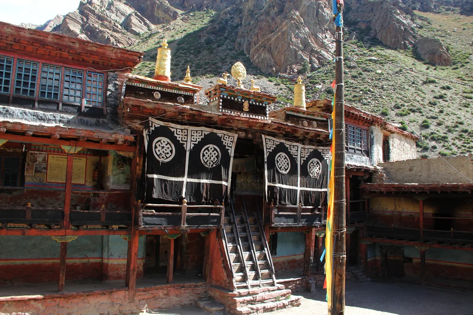
Limi Valley Trek
An 18-day restricted-area loop: fly to Simikot, follow the Humla Karnali to Hilsa and over the Nara La to Til, Halji and Jang, return over the Nyalu La and walk back to Simikot.
- 天數18
- 最高海拔4,940 公尺
- 距離193 公里
- 爬升8,448 公尺
- 難度困難
- 最佳月份Apr–Jun, Sep–Nov
- 許可2
照片:Wang Lama · CC BY-SA 4.0
以英文顯示——尚未翻譯。
此行程為草稿,尚未經過確認。請務必與你的嚮導確認各段行程。
Written by FindTrekkingPartner team審閱者:FindTrekkingPartner team我們如何審閱FindTrekkingPartner
Limi Valley Trek是位於尼泊爾Humla地區的 18 天健行路線,最高海拔達 4,940 公尺。外國健行者可以在 FindTrekkingPartner 發布行程,填入日期、預算與步調,為這條路線尋找夥伴。在雙方健行者都同意之前,配對結果會保持私密,且服務完全免費。 以中等價位計算,四位健行者共用時,持照嚮導 18 天的費用約為每人 168 美元(USD),一人獨自健行則為 672 美元(USD)。最佳季節為Apr–Jun, Sep–Nov。 這裡是受限地區,因此透過登記代理商聘請持照嚮導是許可證的一部分,整個團隊須使用同一份代理商許可證一起行動。 這條路線的開放行程列於下方,附有出發月份、團隊人數與剩餘名額。 最後查證日期:2026年10月19日。資料來源:尼泊爾旅遊局(Nepal Tourism Board)、DNPWC、移民局。
資料來源:Department of Immigration, NepalNepal Tourism BoardDepartment of National Parks and Wildlife Conservation
尋找Limi Valley Trek的夥伴
- 尋找Limi Valley Trek的夥伴目前尚無開放行程
概覽
從 Kathmandu 出發埡口:Nara La, Lamka La, Nyalu La18 天 · 最高 4,940 公尺
最佳季節:Apr–Jun, Sep–Nov · 許可:Humla restricted-area permit (Department of Immigration, via a registered agency), TIMS card issued through a registered agency
The Limi Valley trek is an 18-day loop through the far north-west of Nepal, from Simikot, the district capital of Humla, up the Humla Karnali to Hilsa on the Tibet border and over the Nara La to the three Limi villages of Til, Halji and Jang. It flies from Kathmandu to Nepalgunj and on to Simikot, walks through Dharapuri, Kermi, Yalbang, Tumkot and Yari to Hilsa, crosses the Lamka La to Til, visits Halji and Jang, then takes the long wilderness stages via Talung and the Nyalu La to Shinjungma, returns to Kermi and Simikot, and flies out. The walking covers about 190 km with 8,400 m of climbing, following four operator itineraries. Humla is a restricted area: the Nepal Tourism Board lists the permit at USD 50 per person for the first week, plus USD 10 per day after, through a registered agency, with a licensed guide. The seasons are April to June and September to November, and the flights need spare days.
What the trek is like
The first six days follow the Karnali upstream through pine forest and Tibetan-influenced villages with stone houses and monasteries. After Hilsa the valley opens into the high Limi plateau, with barley fields and juniper, then the three villages. The trek's second half is a remote loop with no villages for two days before Kermi.
Permits and rules
The restricted-area permit is arranged through a registered trekking agency. The Nepal Tourism Board gives the fee as USD 50 per person for the first week and USD 10 per day beyond it. A licensed guide through a registered agency is required. Since 22 March 2026 one trekker can apply, so a group of two is no longer a minimum, but a partner halves the guide cost. A TIMS card is also arranged by the agency.
Best season
April to June and September to November; avoid December to February. Passes need clear weather, and the monsoon brings landslides and flight cancellations.
Altitude
You climb from Simikot at about 2,950 m to Yari at about 3,700 m in four days and cross the Nara La at about 4,620 m. The highest night is Talung at about 4,370 m, below the Nyalu La at about 4,940 m. There are no spare acclimatisation days in this plan, so build one into the Hilsa to Til section or add a day at Jang.
Getting there and away
Fly Kathmandu to Nepalgunj and on to Simikot, then reverse. Flights are often delayed by weather, so keep at least two spare days at the end.
Lodges, food and costs
Facilities are scarce, so the agency supplies the crew, tents and food, with homestays where available. See the costs section for the sourced permit fee and sample costs.
Extensions
You can extend the trek by adding rest days at Jang or Halji, or by continuing from Hilsa towards the Kailash pilgrimage route, which has its own border rules.
亮點
- The Humla Karnali gorge from Simikot to the Tibet border at Hilsa
- Til, Halji and Jang, three Tibetan villages at 3,700 to 4,100 m
- Rinchenling monastery in Halji, a Drikung Kagyu temple
- The Nara La (about 4,620 m) and the Nyalu La (about 4,940 m)
- One of the most remote trekking circuits in Nepal
路線地圖
路線資料來自 OpenStreetMap,尚未經我們團隊查核。請用於規劃,而非導航。
逐日行程
你今晚的過夜海拔比前一晚高 2,800 公尺,超過一般 500 公尺的準則。請放慢速度、多喝水,並留意是否頭痛或噁心。
Fly from Nepalgunj to Simikot in a small plane, about 40 to 45 minutes over the Churen Himal, landing on the high strip above the town at about 2,900 to 2,950 m. Simikot is the district capital of Humla, with a bazaar, a hospital and a few lodges. Flights are often delayed by wind or cloud, and the day may turn into a wait at the airstrip. Walk around the town, drink water and let the body adjust to the altitude. Your crew will finalise loads for the porters.
The first walk descends from Simikot over a ridge and through forest, passing the village of Majgaon, to Dharapuri at about 2,300 m, near the Humla Karnali. Operators give 4 to 5 hours; our mapped route is about 9 km with a net descent. The path has a short climb to a pass at about 3,000 m, then a long descent. Dharapuri is a lower, warmer village on the river, with fields and a few lodges or camping areas. You will start to hear the Karnali from here on.
Follow the Humla Karnali upstream to Kermi, at about 2,670 m, in about 4 hours and 10 km. The path runs through pine forest, villages and fields, with the river always nearby, though on our mapped route it follows tracks and roads that run along the valley. Kermi is known for its hot springs, so you can soak your legs after the walk. There are lodges and camping places. It is an easy day, so use it to get your pace right and drink well, because the altitude rises quickly over the following days.
Continue up the Karnali, crossing a small pass and a suspension bridge over the Salli river, to Yalbang, at about 3,020 m. Operators give 5 to 6 hours for the 11 km, with about 600 m of climbing. The first Tibetan-style village on the route has stone houses and a gompa. Walk gently, as you gain height quickly; sleeping above 3,000 m, you may feel the first headache. The crew can pitch tents near the village or use basic lodging, and the river valley opens up around you.
Climb gradually to Tumkot, at about 3,380 m, passing farms and rocky slopes on a walk of 5 to 6 hours and about 14 km. Tumkot has the Dhungkar Choezom monastery, mentioned in operator itineraries, and a pleasant setting above the river. Operators sometimes stop at Muchu instead, a shorter walk of about 4 hours that splits the day. The air is dry here and the sun strong, so use sun cream and carry plenty of water, since the slopes give little shade. Keep an eye on how everyone in the group is feeling, as the nights now start above 3,000 m.
Pine gives way to juniper as you climb above 3,500 m, on a walk of 4 to 5 hours and about 14 km to Yari, at about 3,700 m, near the first high-altitude pastures. Some groups camp a little beyond at Thado Dunga, about 30 minutes further. Keep a slow pace, drink often and watch your appetite and sleep. Tomorrow is the first pass, the Nara La, so go to bed early and check that your jacket, hat and gloves are within easy reach for the early start.
Cross the Nara La, at about 4,620 m, in a long day of 6 to 7 hours and about 20 km on our mapped route, with about 860 m of climbing, then descend to Hilsa, at about 3,720 m, on the Tibet border. The pass is the traditional pilgrim route to Mount Kailash. Hilsa sits on the Karnali beside a bridge to Tibet, with a hospital, and the Great Himalaya Trail's Nepal section ends here. Start early to cross before the wind and cloud, and stay close to your guide.
Follow the upper Karnali towards Limi in 5 to 6 hours, on rocky and in places steep ground, to a campsite at Manepeme at about 3,900 m, beside the river. On our mapped route it is 11 km with a gain of about 700 m, with a mix of tracks and road. The valley is wide and treeless, and you are well into Tibetan country: look for prayer flags, mani walls and herders. The camp is cold at night, so layer up, drink warm drinks and keep your water bottle from freezing.
Cross the Lamka La, at about 4,300 m, and enter the Limi valley, then reach Til, the first of the three Limi villages, at about 4,000 m, after about 6 hours and 12 km. Til is a stone-house village among barley fields, with views of the valley. It is the first of three villages in a very remote valley. The crew camps near the village or arranges homestays. Eat well, rest and take it easy on the second night at altitude.
Descend to the Limi river and follow the valley to Halji, the largest Limi village, at about 3,660 m, in about 3 to 4 hours and 9 km. Halji's Rinchenling monastery belongs to the Drikung Kagyu school, and popular accounts date it to the 11th century, although other scholars place it later. Ask your guide to arrange a visit and be respectful: remove your hat and shoes, ask before taking photos and walk clockwise around chortens. You have time in the afternoon to wander the village lanes.
Walk up the valley to Jang, the highest of the three Limi villages, at about 3,930 m, through barley fields and pasture. Operators give 4 hours for the 9.5 km, and Travels with Teri adds an acclimatisation rest day here. Jang has stone houses, a gompa, mani walls and prayer flags, and the sunsets are fine. The next day starts a long remote stretch, so use the afternoon to check your gear, repack and charge devices. You will not see a village again until Kermi.
A long, empty stage of about 8 hours and 17 km climbs to Talung, at about 4,370 m, the highest overnight of the trek. There are no villages until Kermi, so this is the start of a wilderness section. The trail follows the valley across open slopes and passes small herders' camps. Pace yourself and drink often: you sleep above 4,000 m and tomorrow is the hardest day. Use your layers and a warm sleeping bag; frost is common at the camp.
The hardest day: a long climb to the Nyalu La, at about 4,940 to 5,000 m depending on the source, then a long descent to Shinjungma, at about 3,620 m. Operators give about 8 hours; our mapped route is 21 km with about 1,300 m of descent. The pass has wide views of the valleys behind and ahead. Start at first light, carry a packed lunch and check the weather: if a storm or heavy snow threatens, your guide may decide to wait. Descend slowly on the loose ground, using poles to save your knees.
Descend through birch and pine forest to the Karnali valley and the hot springs at Kermi, at about 2,670 m, in about 7 hours and 15 km, mostly downhill. The trail drops almost 1,000 m. You return to lodges and a lower, warmer climate, and the evening soak at Kermi is a reward. If you are tired, take the descent slowly: the knees take a beating. Tonight you are back among villages and fields, and the crew will want a celebration dinner.
Walk back to Simikot in about 6 to 7 hours, a day of about 19 km and 1,100 m of climbing, mostly uphill after Dharapuri. Operators split this day in other itineraries (Kermi to Dharapuri, then Dharapuri to Simikot), which makes for a gentler pace. The trail follows the Karnali downstream, then climbs the ridge past Majgaon to Simikot. Check in at a lodge and reconfirm the flight. Keep your boots and poles handy in case the plane is delayed and you need to fill a day.
Fly from Simikot to Nepalgunj, about 40 to 45 minutes, usually in the morning, weather permitting. If the wind keeps the plane on the ground, your agency can arrange a spare day in Simikot. Flights are the most common cause of delay on this trek. In Nepalgunj you transfer to the hotel, wash and rest, then use the afternoon to book the onward flight to Kathmandu or to sort the paperwork with the agency. The town is hot and dusty after the mountains, so drink plenty of water and enjoy a proper shower and a restaurant meal.
你今晚的過夜海拔比前一晚高 1,250 公尺,超過一般 500 公尺的準則。請放慢速度、多喝水,並留意是否頭痛或噁心。
Fly from Nepalgunj to Kathmandu, about an hour, and transfer to your hotel. If the Simikot flight ran on schedule, you may be able to take an earlier connection. Back in the capital, hand back any rented gear, settle accounts with the crew and say your thanks, then check that your passport, receipts and permit copies are all in order. Use the evening to eat out, sort photos and rest your legs. If you have a spare day before your international flight, a visit to Patan or Boudhanath will contrast with the remote valleys you have just left.
高度適應
逐夜的過夜海拔。紅色長條表示比前一晚爬升超過 500 公尺;休息日會另外標示。
- 過夜海拔
- 爬升超過 500 公尺
- 休息日
費用
每人的全包估計費用:依海拔計算的旅舍與餐食、交通、許可,以及嚮導與挑夫。分攤嚮導與挑夫的健行者越多,每個人付的就越少。 截至 2026年10月。
| 風格 | 1 位健行者分攤 | 2 位健行者分攤 | 4 位健行者分攤 |
|---|---|---|---|
| 經濟 | US$1,200–US$1,800* | US$990–US$1,450* | US$870–US$1,250* |
| 中等 | US$1,550–US$2,350* | US$1,250–US$1,850* | US$1,100–US$1,650* |
| 舒適 | US$1,750–US$2,600* | US$1,500–US$2,250* | US$1,400–US$2,050* |
分攤嚮導,省下開銷
以中等價位計算,單獨健行者約需支付 US$1,550–US$2,350;四位健行者分攤一位嚮導和兩位挑夫,每人約 US$1,100–US$1,650(以價格區間上限計算,少 30%)。
2 位健行者分攤的費用明細
| 項目 | 經濟 | 中等 | 舒適 |
|---|---|---|---|
| 旅舍與餐食 | US$400–US$640 | US$540–US$850 | US$720–US$1,100 |
| 交通 | US$200–US$290 | US$200–US$290 | US$200–US$290 |
| 許可 | US$150–US$160 | US$150–US$160 | US$150–US$160 |
| 嚮導 | US$230–US$360 | US$230–US$360 | US$230–US$360 |
| 挑夫 | — | US$100–US$180 | US$210–US$360 |
經濟型使用大眾運輸且不請挑夫;中等價位為兩位健行者共用一位挑夫和一輛包車;舒適型則每位健行者各有一位挑夫。在規定需要嚮導,或風格為中等價位或舒適型時,費用已包含嚮導。
每晚旅舍與餐食(房間與一份 dal bhat 餐)
3 晚Below 2,500 m:房間 US$2–US$9,dal bhat US$4–US$7 · 10 晚2,500 to 3,800 m:房間 US$4–US$11,dal bhat US$5–US$11 · 4 晚Above 3,800 m:房間 US$7–US$19,dal bhat US$8–US$13
許可費用(官方來源)
不含
找不到以下項目的公開價格:Nepalgunj to Simikot flight (return)。標有 * 的總額未計入這些項目;請向旅行社詢問。 這是露營式健行:工作人員、帳篷與餐食由旅行社報價。 Camping trek: crew, tents, kitchen and food are quoted by the agency and are not in this estimate.
費用來源
- PriceNepal: Nepal Travel Cost Guide 2026 (2026-05-14)
- Third Rock Adventures: Nepal trek budget planner (2026-05-09)
- Himalayan Partner: Guide and porter price in Nepal 2026 (2026-02-10)
- Shikhar Adventure: Annapurna Circuit trek cost (2026-02-03)
- Nepal Tourism Board: Trekking Permit (2026-10-18)
估算依據業者指南,並非報價。小費、保險、裝備與加德滿都的飯店不包含;美元依平台匯率計算。
照片
常見問題
Yes. Humla is a restricted area. The Nepal Tourism Board lists USD 50 per person for the first week and USD 10 per day beyond, arranged through a registered agency. Operators also require a licensed guide.
This plan takes 18 days from Kathmandu to Kathmandu: two days of flights at each end, 14 days on foot and no spare day. Most operators allow 18 to 21 days.
Operators give about 4,940 to 4,949 m; one says 5,001 m. The Nara La is about 4,620 m and the Lamka La about 4,300 m.
Not in this plan, although Travels with Teri adds an acclimatisation day at Jang. Add a day at Til or Jang if you can; flight buffer days are separate.
No. Humla is a restricted area and a licensed guide and a registered agency are required. Since 22 March 2026 one trekker can apply, so you no longer need a group of two, but a partner halves the guide cost.
No. It is a long, remote route with passes above 4,600 m, 14 walking days and slow evacuation. Experience of multi-week high-altitude trekking is expected.
資料來源
沿途地點
路線每一天沿途的住宿、醫療協助、水源與景點。
1. Kathmandu → Nepalgunj
- Tribhuvan International Airport · 機場與交通 · 1,340 公尺
Show all 2 places
- Tribhuvan International Airport · 機場與交通 · 1,340 公尺
- Nepalgunj Airport · 機場與交通 · 165 公尺
2. Nepalgunj → Simikot
- Simikot Airport · 機場與交通 · 2,818 公尺
Show all 2 places
- Simikot Airport · 機場與交通 · 2,818 公尺
- Simikot Airpot Helipad · 機場與交通 · 2,971 公尺
3. Simikot → Dharapuri
- Humla District Hospital · 醫療 · 2,937 公尺
- Laxmi Aayurbedic Medical Hall · 醫療 · 2,949 公尺
- Hotel Panchamukhi · 住宿 · 2,981 公尺
- Hotel Mansarovar · 住宿 · 2,986 公尺
- Water_tap · 實用資訊 · 3,036 公尺
- Raling hotel · 住宿 · 2,990 公尺
- Drinking Water · 實用資訊 · 3,265 公尺
- Namaste Shahi Hotel · 住宿 · 2,343 公尺
Show all 13 places
- Hotel Panchamukhi · 住宿 · 2,981 公尺
- Laxmi Aayurbedic Medical Hall · 醫療 · 2,949 公尺
- Kishan Micro Finance · 實用資訊 · 2,992 公尺
- Hotel Mansarovar · 住宿 · 2,986 公尺
- Humla District Hospital · 醫療 · 2,937 公尺
- Water_tap · 實用資訊 · 3,036 公尺
- Raling hotel · 住宿 · 2,990 公尺
- SB Hotel · 住宿 · 2,995 公尺
- Sunny Guest House · 住宿 · 3,006 公尺
- Sun Valley Resort Hotel · 住宿 · 3,022 公尺
- Drinking Water · 實用資訊 · 3,265 公尺
- Manshorowar Shari Hotel · 住宿 · 2,483 公尺
- Namaste Shahi Hotel · 住宿 · 2,343 公尺
4. Dharapuri → Kermi
- Tarku Khola Hotel · 住宿 · 2,414 公尺
- Teahouse · 住宿 · 2,490 公尺
- Kalakaghun Hotel [extremely basic - 2026] · 住宿 · 2,478 公尺
5. Kermi → Yalbang
- Kermi Camp Side · 住宿 · 2,795 公尺
6. Yalbang → Tumkot
- Drinking Water · 實用資訊 · 2,980 公尺
- Riverside Hotel · 住宿 · 3,088 公尺
- Homestay Yalbang · 住宿 · 3,082 公尺
- Namkhyung Mahamaya Basic School Playground · 機場與交通 · 3,118 公尺
- Humla Himalyan Hotel - [lot of drunk people] · 住宿 · 3,125 公尺
7. Tumkot → Yari
- Drinking Water · 實用資訊 · 3,182 公尺
- Yari Hotel · 住宿 · 3,784 公尺
8. Yari → Hilsa
- Himalaya Guest House · 住宿 · 3,786 公尺
- Hotel Snow Lion · 住宿 · 3,643 公尺
- Special Health Camp · 醫療 · 3,632 公尺
- Hilsa Hospital · 醫療 · 3,639 公尺
- Khang Jong Limi Hotel · 住宿 · 3,638 公尺
9. Hilsa → Manepeme
- Hotel Manasovar Restaurant and Bar · 住宿 · 3,633 公尺
- Sange Hotel and Lodge · 住宿 · 3,630 公尺
- Himalaya Hotel, Restaurant and Bar · 住宿 · 3,632 公尺
10. Manepeme → Til
- On the way to Hilsha from Til · 觀景點 · 4,265 公尺
- Drinking Water · 實用資訊 · 3,933 公尺
11. Til → Halji
- Drinking Water · 實用資訊 · 3,930 公尺
12. Halji → Jang
- Drinking Water · 實用資訊 · 3,732 公尺
13. Jang → Talung
- Limi Resort, Tokche, Tumling · 住宿 · 4,179 公尺
- Selima Tso · 自然 · 4,259 公尺
14. Talung → Shinjungma
這一天尚未標繪任何地點。這一天尚未標繪任何地點。15. Shinjungma → Kermi
- Salli Lodge and Restaurant · 住宿 · 2,975 公尺
16. Kermi → Simikot
- Drinking Water · 實用資訊 · 2,373 公尺
- Dharapori Hotel [Open - 2026] · 住宿 · 2,342 公尺
- Sunshine Medical Hospital · 醫療 · 2,955 公尺
- Simikot lagna · 觀景點 · 3,233 公尺
- Hotel Bijaya · 住宿 · 3,011 公尺
- Kailash - 2026 · 住宿 · 3,009 公尺
- CFD Humla · 住宿 · 3,015 公尺
- Health Us Nepal Medical Center · 醫療 · 2,961 公尺
Show all 11 places
- Chyachhara Jharna · 自然 · 2,456 公尺
- Drinking Water · 實用資訊 · 2,373 公尺
- Dharapori Hotel [Open - 2026] · 住宿 · 2,342 公尺
- Manshorowar Shahi Hotel - 2026 · 住宿 · 2,499 公尺
- Sunshine Medical Hospital · 醫療 · 2,955 公尺
- Dada Hotel · 住宿 · 3,271 公尺
- Simikot lagna · 觀景點 · 3,233 公尺
- Hotel Bijaya · 住宿 · 3,011 公尺
- Kailash - 2026 · 住宿 · 3,009 公尺
- CFD Humla · 住宿 · 3,015 公尺
- Health Us Nepal Medical Center · 醫療 · 2,961 公尺
17. Simikot → Nepalgunj
這一天尚未標繪任何地點。這一天尚未標繪任何地點。18. Nepalgunj → Kathmandu
這一天尚未標繪任何地點。這一天尚未標繪任何地點。
最後確認於 2026年10月19日回報過時資訊