

Fly from Kathmandu to Nepalgunj, about an hour south-west over the foothills to the hot Terai plains near the Indian border. Nepalgunj is the hub for flights to far-west Nepal, and it is often very hot and humid. Transfer to your hotel, check permits with your guide and use the afternoon to repack and rest. Flights to Juphal leave early the next morning and depend on the weather, so keep your schedule flexible. Drink plenty of water and have an early night.
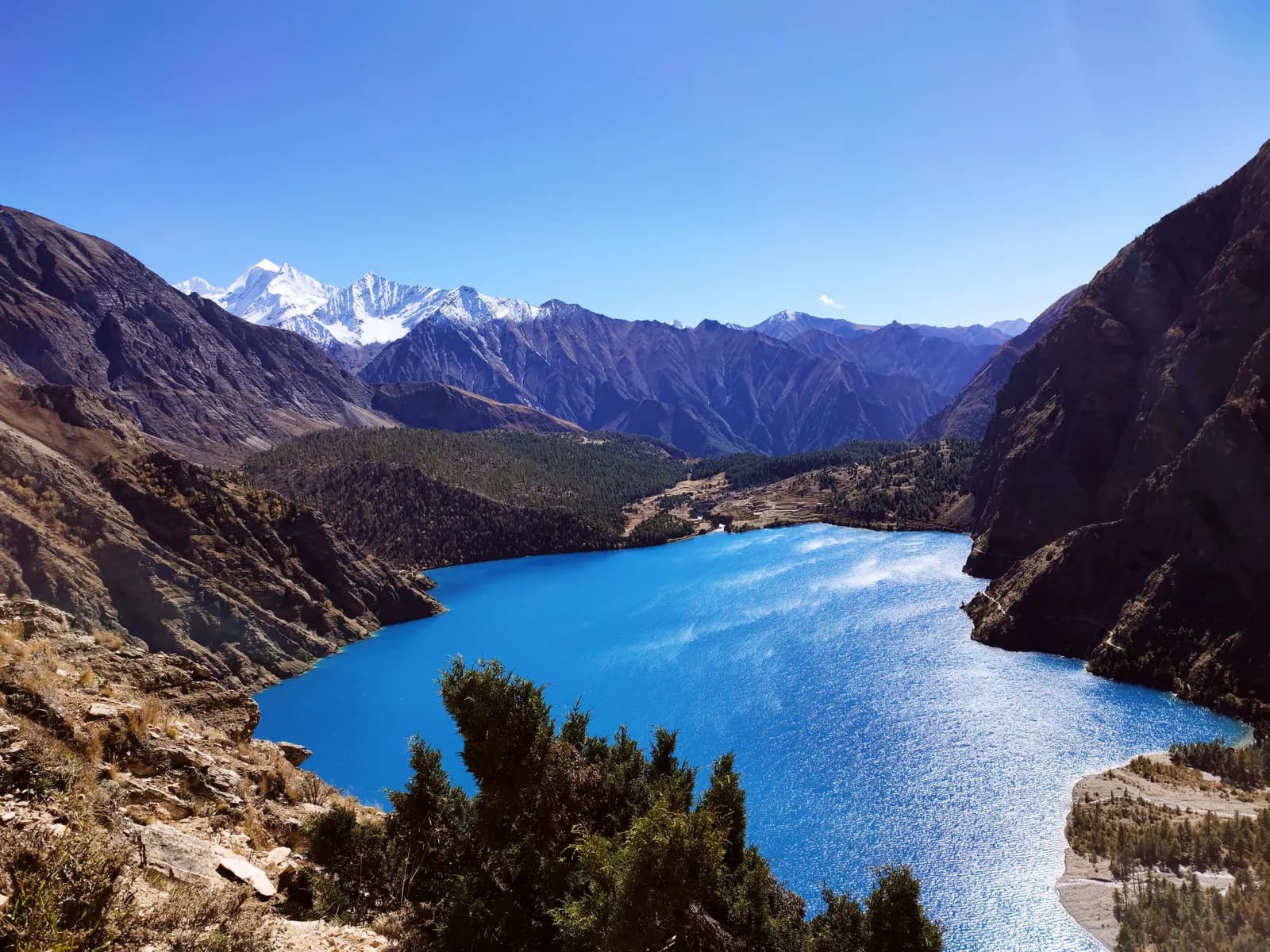
Phoksundo Lake Trek (Lower Dolpo)
A 10-day trek into Shey Phoksundo National Park to Ringmo and Phoksundo Lake, with flights to Juphal and no restricted-area permit.
- 天數10
- 最高海拔3,640 公尺
- 距離90.4 公里
- 爬升4,535 公尺
- 難度中等
- 最佳月份Apr–Jun, Sep–Nov
- 許可2
照片:Kiran Dhodari · CC BY 4.0
以英文顯示——尚未翻譯。
此行程為草稿,尚未經過確認。請務必與你的嚮導確認各段行程。
Written by FindTrekkingPartner team審閱者:FindTrekkingPartner team我們如何審閱FindTrekkingPartner
Phoksundo Lake Trek (Lower Dolpo)是位於尼泊爾Dolpo地區的 10 天健行路線,最高海拔達 3,640 公尺。外國健行者可以在 FindTrekkingPartner 發布行程,填入日期、預算與步調,為這條路線尋找夥伴。在雙方健行者都同意之前,配對結果會保持私密,且服務完全免費。 以中等價位計算,四位健行者共用時,持照嚮導 10 天的費用約為每人 93 美元(USD),一人獨自健行則為 373 美元(USD)。最佳季節為May–Jun, Sep–Oct。 這裡是受限地區,因此透過登記代理商聘請持照嚮導是許可證的一部分,整個團隊須使用同一份代理商許可證一起行動。 這條路線的開放行程列於下方,附有出發月份、團隊人數與剩餘名額。 最後查證日期:2026年10月19日。資料來源:尼泊爾旅遊局(Nepal Tourism Board)、DNPWC、移民局。
資料來源:Department of Immigration, NepalNepal Tourism BoardDepartment of National Parks and Wildlife Conservation
尋找Phoksundo Lake Trek (Lower Dolpo)的夥伴
概覽
從 Kathmandu 出發10 天 · 最高 3,640 公尺
最佳季節:Apr–Jun, Sep–Nov · 許可:Shey Phoksundo National Park entry permit, TIMS card where required
The Phoksundo Lake trek is a 10-day journey into the lower valleys of Dolpo, in Dolpa District of north-west Nepal, ending beside one of the country's deepest and most beautiful lakes. It flies from Kathmandu to Nepalgunj and on to Juphal, walks along the Thuli Bheri and Suligad rivers through Dunai and Sulighat to Chhepka and Ringmo, spends a rest day at the lake at about 3,610 m, and returns the same way before the flights home. The walk covers about 90 km with 4,500 m of climbing and, unlike Upper Dolpo, needs no restricted-area permit, only the Shey Phoksundo National Park permit. It is a moderate trek with long days, simple lodges and a remote feel, suitable for fit walkers. April to June and September to November are the best months. Allow spare days for the flights, which are weather dependent.
What the trek is like
From Juphal the trail drops to Dunai, a small district town on the Thuli Bheri river, then follows the Suligad river into a deep, dry gorge. After the park entrance at Sulighat it climbs through blue pine, birch and juniper to Chhepka, a village of stone houses and fields. The last day to the lake climbs through forest and past waterfalls to a high saddle and the first view of Phoksundo, a turquoise lake in a bowl of rock and snow. Ringmo sits at the southern end, with chortens, a Bon monastery and flat-roofed houses. The return takes the same route in shorter days.
Highlights
- Phoksundo Lake, which covers about 494 hectares and was designated a Ramsar site in 2007
- The waterfall of about 167 m where the lake drains
- Ringmo village and its Bon monastery and chortens
- The Suligad gorge, dry forest and walnut and apple trees near Dunai
- A rest day with time to see the lake from several viewpoints
Permits and rules
You need the Shey Phoksundo National Park entry permit, arranged through your agency or bought at the checkpost, and a TIMS card where the local office asks for it. The Phoksundo trek is not a restricted-area trek. The Nepal Tourism Board April 2023 rule requires foreign trekkers to use a licensed guide in national parks and conservation areas, and 2026 operator reports say checkpoints enforce it in Annapurna (ACAP), Langtang (the strictest) and most other parks, but not in Khumbu, where the municipality opted out (checked 19 October 2026). See the guide rule by region. Ask for current fees and check them with the park or the Department of National Parks and Wildlife Conservation.
Best season
April to June and September to November are the best months. Spring has clearer air and flowers, and autumn brings stable weather. Dolpo lies in the rain shadow, so the monsoon is milder than elsewhere, but flights are often disrupted by cloud over Nepalgunj and the airstrip. Winter is cold, with snow around Ringmo and a frozen lake.
Altitude
Ringmo, at about 3,640 m, is the highest point. Chhepka (about 2,660 m) and Ringmo are separated by a long, steep climb of nearly 1,700 m, so take it slowly. The rest day at the lake helps acclimatisation, and you sleep at the same altitude. Watch for headache, nausea and poor sleep, never ascend with symptoms, and descend if they worsen. Discuss altitude medicine with your doctor.
Getting there and away
Fly Kathmandu to Nepalgunj, then Nepalgunj to Juphal on a small plane. The return reverses this. Both flights depend on weather, and Juphal flights are often delayed, so keep one or two spare days. There is no road to Ringmo.
Lodges, food and costs
Simple lodges operate at Juphal, Dunai, Chhepka and Ringmo, with dal bhat, noodles, eggs and tea. Rooms are basic, with blankets and sometimes heating, and hot showers are rare. Many agencies still provide tents and a cook for flexibility. Prices rise with altitude, and you should bring cash for the whole trek, because Dunai has few services.
Packing list
Broken-in boots, waterproof layers, a down jacket, a sleeping bag rated to about minus 10 C, gloves, hat, sunglasses, sun cream, trekking poles, a headlamp, water purification and a first-aid kit. A sun hat is useful, because the valley is bright and dry.
Who this trek suits and how to prepare
The trek suits fit walkers who want a remote trek without extreme altitude or a restricted-area permit. The days are long, with 20 to 25 km on two of them, so prepare with hill walks and some days with a loaded pack. Previous multi-day trekking is helpful.
The plan at a glance
Days 1 and 2 fly to Nepalgunj and Juphal. Day 3 walks to Chhepka and day 4 to Ringmo, with a rest day on day 5. Days 6 to 8 return to Chhepka, Dunai and Juphal, and days 9 and 10 fly back to Kathmandu via Nepalgunj.
Extensions
Add a day or two for weather at Juphal or Nepalgunj. For a longer trek, continue from Ringmo to Lar Tsa along the lake, or join the Upper Dolpo trek over the Kang La, which needs a restricted-area permit. You can also visit the Dunai bazaar and the monasteries near Juphal.
Practical tips from the trail
- Walking times in the day plan are estimates from distance and climb, checked against operator itineraries; real times differ with pace, load and weather.
- Keep spare days for the Juphal flights.
- Start early on the long climb from Chhepka to Ringmo.
- Carry sun protection and water, because the trail is dry and exposed.
- Respect the monasteries and walk clockwise around chortens.
- Do not swim or wash in the lake, which is sacred and protected.
Responsible trekking
Take rubbish out, use filtered water, avoid wood fires in the national park and buy from local families. Ask before photographing people and ceremonies.
亮點
- Phoksundo Lake, a Ramsar lake at about 3,610 m
- Ringmo, a Tibetan-style village beside the lake
- The 167 m waterfall at the lake outlet
- Dunai and the Thuli Bheri valley of lower Dolpo
- Bon and Buddhist monasteries, chortens and mani walls
路線地圖
路線資料來自 OpenStreetMap,尚未經我們團隊查核。請用於規劃,而非導航。
逐日行程
你今晚的過夜海拔比前一晚高 2,330 公尺,超過一般 500 公尺的準則。請放慢速度、多喝水,並留意是否頭痛或噁心。
Take the morning flight from Nepalgunj to Juphal, about 40 minutes on a small plane over green foothills and, on clear days, the Dhaulagiri range. The airstrip lies at about 2,490 m above Dunai, the district headquarters of Dolpa. The air is cool and dry after the plains. Meet your crew, show your permits at the checkpost and sort the loads. If the flight is cancelled, you spend another night in Nepalgunj, so plan flexible days. The trek starts tomorrow. Keep warm layers at hand, because the airstrip is cool.
A long first walking day from Juphal to Chhepka at about 2,660 m. The trail drops to the Thuli Bheri, passes through Dunai and follows the Suligad river to Sulighat, the entrance to Shey Phoksundo National Park, then climbs on to Chhepka. It is about 25 km with 1,150 m of climbing, taking 7 to 10 hours, so many groups split the day with a camp at Sulighat. The valley is dry and rocky, with blue pine and walnut trees. Chhepka has simple lodges.
你今晚的過夜海拔比前一晚高 980 公尺,超過一般 500 公尺的準則。請放慢速度、多喝水,並留意是否頭痛或噁心。
A hard day from Chhepka to Ringmo at about 3,640 m, about 20 km with 1,670 m of climbing, taking 6 to 9 hours. The trail follows the Suligad river through Rechi and Sanduwa, with steep rock steps, waterfalls and forest, then opens to the lake basin, where Phoksundo Lake comes into view at about 3,610 m. Ringmo is a village of flat-roofed stone houses, chortens and a Bon monastery. Rest, eat well and enjoy the first evening view of the lake.
A rest and acclimatisation day at Ringmo. Walk to the shore of Phoksundo Lake, about 3,610 m, and visit the monastery and chortens in Ringmo. The water is a deep turquoise, and the waterfall below the village drops about 167 m. Take short walks to viewpoints and enjoy the views of the Kanjiroba range, but keep a slow pace. Use the afternoon to rest and wash clothes. Avoid swimming or washing in the lake, which is sacred and protected. Take the afternoon off to rest and write notes.
Descend from Ringmo to Chhepka at about 2,660 m, about 20 km with 1,680 m of descent and 700 m of climbing, taking 6 to 8 hours. The route retraces the Suligad river through Sanduwa and Rechi, with waterfalls and forest, and the air warms as you drop. The steep steps are hard on the knees, so use poles and take breaks. Chhepka's lodges are simple but welcoming. Enjoy a hot meal and an early night after the long day. Check the weather forecast with your guide before bed.
Walk from Chhepka to Dunai at about 2,090 m, about 14.5 km with a climb of 420 m and a descent of 990 m, taking 4.5 to 6 hours. The trail follows the Suligad river through Sulighat, leaves the national park and ends in Dunai, the district town on the Thuli Bheri. Dunai has a bazaar, a hospital, a small gompa and basic lodges. Use the afternoon to walk around the town, buy snacks and sort your belongings. The climate is warmer and drier than at Ringmo.
A short walk from Dunai to Juphal at about 2,490 m, about 10 km with a climb of 560 m, taking 4 to 5 hours. The trail leaves the river and climbs through dry hills and villages to the airstrip, with views of the Thuli Bheri valley and the surrounding ranges. Juphal has a few lodges, and the airport office checks your flight status. Keep a spare day in the schedule in case the weather closes the airstrip. Pack your bags and prepare for the morning flight.
Fly from Juphal to Nepalgunj, about 40 minutes over foothills and valleys, and transfer to a hotel. The air is hot and humid after the high valleys, and you may want a shower and a cold drink. If the Kathmandu flight is the same day, you connect at the airport, otherwise use the afternoon to rest. Flights from Juphal are often delayed by cloud, so keep a buffer. Your agency will arrange the hotel and onward tickets. Keep your passport and flight tickets within easy reach.
你今晚的過夜海拔比前一晚高 1,240 公尺,超過一般 500 公尺的準則。請放慢速度、多喝水,並留意是否頭痛或噁心。
Fly from Nepalgunj to Kathmandu, about an hour, and transfer to your hotel. The flight offers a last view of the Himalaya on clear mornings. Back in Kathmandu, you can shower, repack and explore Thamel or Patan. Keep a spare day after the trek in case of flight delays. Tip your guide and porters according to your agency's guidelines, and celebrate a short, remote journey to one of the most beautiful lakes in Nepal. Keep your passport and permit copies in your hand luggage for the airport checks.
高度適應
逐夜的過夜海拔。紅色長條表示比前一晚爬升超過 500 公尺;休息日會另外標示。
- 過夜海拔
- 爬升超過 500 公尺
- 休息日
費用
每人的全包估計費用:依海拔計算的旅舍與餐食、交通、許可,以及嚮導與挑夫。分攤嚮導與挑夫的健行者越多,每個人付的就越少。 截至 2026年10月。
| 風格 | 1 位健行者分攤 | 2 位健行者分攤 | 4 位健行者分攤 |
|---|---|---|---|
| 經濟 | US$380–US$580* | US$380–US$580* | US$380–US$580* |
| 中等 | US$720–US$1,100* | US$580–US$890* | US$540–US$820* |
| 舒適 | US$800–US$1,250* | US$710–US$1,100* | US$670–US$1,050* |
分攤嚮導,省下開銷
以中等價位計算,單獨健行者約需支付 US$720–US$1,100;四位健行者分攤一位嚮導和兩位挑夫,每人約 US$540–US$820(以價格區間上限計算,少 25%)。
2 位健行者分攤的費用明細
| 項目 | 經濟 | 中等 | 舒適 |
|---|---|---|---|
| 旅舍與餐食 | US$160–US$280 | US$230–US$370 | US$310–US$490 |
| 交通 | US$200–US$290 | US$200–US$290 | US$200–US$290 |
| 許可 | US$20–US$30 | US$20–US$30 | US$20–US$30 |
| 嚮導 | — | US$80–US$140 | US$80–US$140 |
| 挑夫 | — | US$40–US$80 | US$90–US$160 |
經濟型使用大眾運輸且不請挑夫;中等價位為兩位健行者共用一位挑夫和一輛包車;舒適型則每位健行者各有一位挑夫。在規定需要嚮導,或風格為中等價位或舒適型時,費用已包含嚮導。
每晚旅舍與餐食(房間與一份 dal bhat 餐)
5 晚Below 2,500 m:房間 US$2–US$9,dal bhat US$4–US$7 · 4 晚2,500 to 3,800 m:房間 US$4–US$11,dal bhat US$5–US$11
許可費用(官方來源)
- Shey Phoksundo National Park entry permit: NPR 3,000 每次入園 來源
不含
找不到以下項目的公開價格:Nepalgunj to Juphal flight (return)。標有 * 的總額未計入這些項目;請向旅行社詢問。
費用來源
- PriceNepal: Nepal Travel Cost Guide 2026 (2026-05-14)
- Third Rock Adventures: Nepal trek budget planner (2026-05-09)
- Himalayan Partner: Guide and porter price in Nepal 2026 (2026-02-10)
- Shikhar Adventure: Annapurna Circuit trek cost (2026-02-03)
- Nepal Tourism Board: Trekking Permit (2026-10-18)
估算依據業者指南,並非報價。小費、保險、裝備與加德滿都的飯店不包含;美元依平台匯率計算。
照片
常見問題
No. Phoksundo and lower Dolpo need only the Shey Phoksundo National Park entry permit. Upper Dolpo, beyond the Kang La, is a restricted area.
The Nepal Tourism Board April 2023 rule requires foreign trekkers to use a licensed guide in national parks and conservation areas, and 2026 operator reports say checkpoints enforce it in Annapurna (ACAP), Langtang (the strictest) and most other parks, but not in Khumbu, where the municipality opted out (checked 19 October 2026). Confirm with a registered agency. A guide is advised on this remote trail in any case.
Ten days from Kathmandu on this plan, including the flights to Nepalgunj and Juphal, two days of walking to Ringmo, a rest day and three days of walking back. Flight delays can add days.
About 3,611 m. Ringmo village is at about 3,640 m, and the lake is among the deepest in Nepal, measured at 136 to 145 m in surveys.
April to June and September to November. The monsoon is milder in Dolpo, but flights are often delayed, and winter freezes the lake.
Moderate. The altitude is below 3,700 m, but two days are long at 20 to 25 km, and the climb from Chhepka to Ringmo is about 1,700 m.
No. The lake is sacred and protected, and washing or swimming is discouraged.
資料來源
- Phoksundo Lake Trek, 11 days (Trekking in Nepal)
- Phoksundo Lake Trekking (Himkala Adventure)
- Phoksundo Lake (Wikipedia)
- Shey Phoksundo National Park (Wikipedia)
- Dolpa District (Wikipedia)
- Department of National Parks and Wildlife Conservation, Nepal
- Nepal Tourism Board
- Himalayan Rescue Association
- OpenStreetMap (elevation tags of villages and the lake)
沿途地點
路線每一天沿途的住宿、醫療協助、水源與景點。
1. Kathmandu → Nepalgunj
- Tribhuvan International Airport · 機場與交通 · 1,340 公尺
Show all 2 places
- Tribhuvan International Airport · 機場與交通 · 1,340 公尺
- Nepalgunj Airport · 機場與交通 · 165 公尺
2. Nepalgunj → Juphal
這一天尚未標繪任何地點。這一天尚未標繪任何地點。3. Juphal → Chhepka
- Dolpa Airport · 機場與交通 · 2,489 公尺
- Drinking Water · 實用資訊 · 2,044 公尺
- Rupgar hotel · 住宿 · 2,070 公尺
- District hospital · 醫療 · 2,090 公尺
- Thapa Hotel · 住宿 · 2,091 公尺
- स्वास्थ्य चौकी कार्यालय परीला डोल्पा · 醫療 · 2,535 公尺
- Shyanta · 住宿 · 2,490 公尺
- Jharana Hotel · 住宿 · 2,666 公尺
Show all 9 places
- Dolpa Airport · 機場與交通 · 2,489 公尺
- Drinking Water · 實用資訊 · 2,044 公尺
- Rupgar hotel · 住宿 · 2,070 公尺
- Army helipad · 機場與交通 · 2,103 公尺
- District hospital · 醫療 · 2,090 公尺
- Thapa Hotel · 住宿 · 2,091 公尺
- स्वास्थ्य चौकी कार्यालय परीला डोल्पा · 醫療 · 2,535 公尺
- Shyanta · 住宿 · 2,490 公尺
- Jharana Hotel · 住宿 · 2,666 公尺
4. Chhepka → Ringmo
- Shey Karnali Hotel · 住宿 · 3,120 公尺
- Saijol Health Post · 醫療 · 3,118 公尺
- Phoksundo Hotel · 住宿 · 3,132 公尺
- Jharana Hotel · 住宿 · 3,131 公尺
5. Ringmo
- Stupid Hotel & Lounge · 住宿 · 3,626 公尺
- Shey Shikhahr Lakeside Hotel&Lodge · 住宿 · 3,632 公尺
- Himalayan Hotel & Lodge · 住宿 · 3,641 公尺
- Mount Kailash Guest House · 住宿 · 3,640 公尺
- Drinking Water · 實用資訊 · 3,640 公尺
- Phoksundo Lake · 自然 · 3,612 公尺
Show all 10 places
- Sherpa Hotel&Lodge · 住宿 · 3,640 公尺
- Stupid Hotel & Lounge · 住宿 · 3,626 公尺
- Shey Shikhahr Lakeside Hotel&Lodge · 住宿 · 3,632 公尺
- Himalayan Hotel & Lodge · 住宿 · 3,641 公尺
- Mount Kailash Guest House · 住宿 · 3,640 公尺
- Shey Phoksundo Hotel view point · 住宿 · 3,637 公尺
- Drinking Water · 實用資訊 · 3,640 公尺
- Ringmo · 住宿 · 3,640 公尺
- New tourist Guest House · 住宿 · 3,650 公尺
- Phoksundo Lake · 自然 · 3,612 公尺
6. Ringmo → Chhepka
- Drinking Water · 實用資訊 · 3,645 公尺
- Viewpoint · 觀景點 · 3,647 公尺
- Chunuwar Health Post · 醫療 · 3,136 公尺
- Amchi Hospital · 醫療 · 3,129 公尺
- Samshana Hotel · 住宿 · 3,055 公尺
- Hotel Pahuna Ghar · 住宿 · 3,032 公尺
- Keshang Hotel · 住宿 · 3,032 公尺
7. Chhepka → Dunai
- Hotel Swagat · 住宿 · 2,492 公尺
- Sunita Hotel · 住宿 · 2,287 公尺
8. Dunai → Juphal
- स्वास्थ्य सेवा कार्यालय, दुनई-डोल्पा · 醫療 · 2,088 公尺
- Dolpa District Hospital · 醫療 · 2,090 公尺
- Drinking Water · 實用資訊 · 2,174 公尺
- Hotel Tripura · 住宿 · 2,487 公尺
- Hotel Mount Putha & Restaurant · 住宿 · 2,475 公尺
- Dolpa Airport · 機場與交通 · 2,499 公尺
- Mount putha · 住宿 · 2,482 公尺
Show all 8 places
- स्वास्थ्य सेवा कार्यालय, दुनई-डोल्पा · 醫療 · 2,088 公尺
- Dolpa District Hospital · 醫療 · 2,090 公尺
- Drinking Water · 實用資訊 · 2,174 公尺
- Jufal health post · 醫療 · 2,434 公尺
- Hotel Tripura · 住宿 · 2,487 公尺
- Hotel Mount Putha & Restaurant · 住宿 · 2,475 公尺
- Dolpa Airport · 機場與交通 · 2,499 公尺
- Mount putha · 住宿 · 2,482 公尺
9. Juphal → Nepalgunj
這一天尚未標繪任何地點。這一天尚未標繪任何地點。10. Nepalgunj → Kathmandu
這一天尚未標繪任何地點。這一天尚未標繪任何地點。
最後確認於 2026年10月19日回報過時資訊