

Drive from Kathmandu to Dhap Bazaar, a ridge settlement at about 2,900 m, which takes seven to nine hours depending on the source and the state of the road. KimKim lists a lunch stop at Ghurmi on the way. The road climbs through hill towns and terraces, and your first night is at a teahouse in Dhap. Dhap's height of about 2,900 m, which most operators give, is in line with the elevation model, which gives about 3,000 m. Use the evening to repack, check your guide's plan for the morning, and rest, because the next days start early.
Pikey Peak Trek
A six-day trek in Solu that climbs from Dhap Bazaar through Jhapre to Pikey Peak (4,065 m) for sunrise over Everest, then descends to Junbesi and Phaplu.
- Ngày6
- Độ cao tối đa4.065 m
- Quãng đường48,6 km
- Độ cao leo2.261 m
- Độ khóTrung bình
- Tháng đẹp nhấtMar–May, Sep–Nov
- Giấy phép3
Lên kế hoạch chuyến đi theo lịch trình nàyTìm bạn đồng hành cho Pikey Peak TrekXem lịch khởi hành theo tuần
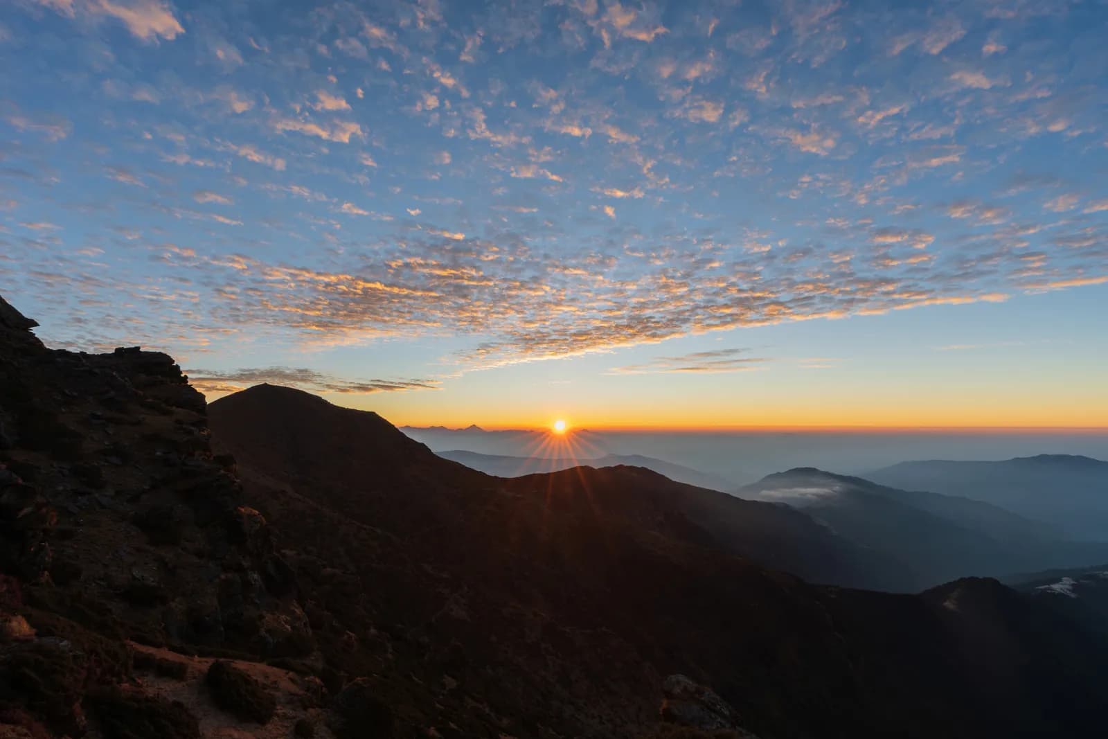
Ảnh: Sunuwargr · CC BY-SA 4.0
Hiển thị bằng tiếng Anh — chưa được dịch.
Lịch trình này là bản nháp và chưa được xác minh. Luôn xác nhận các chặng với hướng dẫn viên của bạn.
Written by FindTrekkingPartner teamĐược FindTrekkingPartner team kiểm duyệtCách chúng tôi kiểm duyệtFindTrekkingPartner
Pikey Peak Trek là chuyến trek 6 ngày ở vùng Solu của Nepal, leo lên độ cao 4.065 m. Trekker nước ngoài có thể tìm bạn đồng hành cho chuyến này trên FindTrekkingPartner bằng cách đăng chuyến đi kèm ngày đi, ngân sách và tốc độ. Các kết nối được giữ riêng tư cho đến khi cả hai trekker đồng ý, và dịch vụ này miễn phí. Ở mức giá tầm trung, một hướng dẫn viên có giấy phép tốn khoảng 56 USD mỗi người trong 6 ngày khi bốn trekker chia sẻ, so với 224 USD cho một trekker đi một mình. Các mùa đẹp nhất là Mar–May, Sep–Nov. Trên thực tế, ở đây bắt buộc có hướng dẫn viên có giấy phép: theo các nhà điều hành năm 2026, quy định tháng 4 năm 2023 của Cục Du lịch Nepal (Nepal Tourism Board) được thực thi tại các trạm kiểm soát ở vườn quốc gia và khu bảo tồn, trong đó Langtang nghiêm ngặt nhất và Annapurna cũng kiểm tra (kiểm tra ngày 19 tháng 10 năm 2026). Hãy thuê hướng dẫn viên qua công ty lữ hành đã đăng ký và xác nhận với họ. Xác minh lần cuối: 19 tháng 10, 2026. Nguồn: Cục Du lịch Nepal (Nepal Tourism Board), DNPWC, Cục Xuất nhập cảnh.
Nguồn:Department of Immigration, NepalNepal Tourism BoardDepartment of National Parks and Wildlife Conservation
Tìm bạn đồng hành cho Pikey Peak Trek
- Tìm bạn đồng hành cho Pikey Peak TrekChưa có chuyến đi đang mở
- Tìm bạn đồng hành cho Dudh Kunda TrekChưa có chuyến đi đang mở
Tổng quan
Khởi hành từ Kathmandu6 ngày · tối đa 4.065 m
Mùa đẹp nhất: Mar–May, Sep–Nov · Giấy phép: No restricted-area permit, Pikey Peak is outside Sagarmatha National Park, Ask your agency about any local trek card
The Pikey Peak trek is a six-day walk through the Solu part of Solukhumbu to a 4,065 m summit that gives one of the best sunrise views of Everest and the Himalaya from outside the Khumbu. A seven to nine hour drive from Kathmandu reaches Dhap Bazaar on the ridge, and the walk then goes through Jhapre and Pikey Base Camp to the summit, down to Junbesi, and along the Junbesi Khola to Phaplu, from where a drive of eight to nine hours returns to the city. The walking is about 48 km with 2,260 m of climbing and 2,790 m of descent. The trail is quieter than the Everest base camp route, passes through oak and rhododendron forest and yak pasture, and has lodges at every stop. The walk needs no flight, no restricted-area permit and no special gear beyond warm clothes for the summit sunrise.
The plan follows a KimKim itinerary and a Nepal Traveller article, which agree on the stops and the Dhap start, and it uses their heights for Jhapre, the base camp and Junbesi only where they match the elevation model. The first day on the road is long, and the second day follows a ridge road, so the real climb starts on day three. The best months are March to May and September to November. Pikey is not a restricted area and lies outside Sagarmatha National Park, so no flight and no special permit are needed.
Difficulty and fitness
The trek is moderate. The longest day is the descent from Pikey Base Camp to Junbesi, about 15 km and 1,670 m down, and the climb from Jhapre to the base camp is about 870 m. The summit climb is short but cold and dark. Good boots and trekking poles help on the descent.
Budget notes
The costs section uses Nepal-wide lodge and meal ranges by altitude, with a guide, a porter and road transport. Fares for the drives to and from Dhap and Phaplu are shown as lines to check, since we found no published prices.
What to pack
A down jacket, hat and gloves for the summit sunrise, a headlamp, rain gear, a warm sleeping bag and water treatment. Lodges give blankets, but nights at Pikey Base Camp, at about 3,640 m, are cold.
Điểm nổi bật
- Sunrise from Pikey Peak at 4,065 m, with Everest and the Khumbu range in view
- Rhododendron forest, yak pasture and the Sherpa and Rai villages of Solu
- Junbesi and the Thubten Choling monastery
- A quieter alternative to the Everest base camp trail
- A road start and finish: no flight is needed
Bản đồ lộ trình
Dữ liệu lộ trình từ OpenStreetMap, nhóm chúng tôi chưa kiểm tra. Hãy dùng để lên kế hoạch, không dùng để dẫn đường.
Từng ngày
Walk about 9.4 km from Dhap Bazaar to Jhapre, four to five hours, through Sigane along a ridge road with small ups and downs. It is the easiest walking day: the climb is only 220 m, with 370 m of descent, and most of it is on a motor road, which operators describe as a forest road. Jhapre is at about 2,815 m according to KimKim and Nepalgram, and the lodges lie in a cluster below Pikey. Spend the afternoon resting, and eat early, because the next day is much longer and steeper.
Bạn ngủ cao hơn đêm trước 825 m, vượt mức khuyến nghị thông thường là 500 m. Hãy đi chậm, uống nhiều nước và chú ý các dấu hiệu đau đầu hoặc buồn nôn.
A day of 13 km and 870 m of climbing, five to seven hours, climbs from Jhapre along the ridge, through rhododendron and yak pasture, to Pikey Base Camp at about 3,640 m. KimKim lists lunch at Lhamuje and a time of five to six hours, and Third Rock Adventures gives six to seven. The path is mostly a footpath, with some road, and views open as you gain height. The lodge at the base camp is simple, and the night is cold. Eat well and go to bed early, because the summit is for sunrise.
Rise before dawn for the climb of about 3 km and 400 m to the summit at 4,065 m, about 1.5 to 2 hours in the dark with a headlamp, by our estimate. At sunrise, Everest and the Khumbu peaks stand above the ridges, and Hillary is said to have favoured the view. Come back to the base camp for breakfast, then walk about 12 km and 1,670 m down to Junbesi at about 2,680 m, the longest day: seven to eight hours with the summit, according to our estimate and an operator that gives eight. The route passes Jasmane Bhanjyang and forest.
Walk about 11 km from Junbesi to Phaplu in four to five hours, mostly downhill along the Junbesi Khola, with a few climbs. Phaplu is at about 2,400 m by KimKim and OpenStreetMap, and the elevation model puts it near 2,490 m. If you have spare time and energy, the Thubten Choling monastery lies a few kilometres north of Junbesi, and a round trip takes about three hours. Your lodge in Phaplu is close to the airstrip, and the town is the district's road and air hub, so it is a comfortable last night in the hills.
Drive from Phaplu to Kathmandu, a journey of about eight to nine hours. The road retraces much of the way to Kathmandu through Okhaldhunga district and over several ridges, and it is bumpy in places. Some trekkers take the short flight from Phaplu instead if the weather allows, which saves most of the day, but flights are often cancelled in cloud, so keep the road as your fallback. If you have a flight out of Nepal, leave a spare day before it.
Thích nghi độ cao
Độ cao nơi ngủ từng đêm. Các cột màu đỏ cao hơn đêm trước hơn 500 m; ngày nghỉ được đánh dấu.
- Độ cao nơi ngủ
- Tăng trên 500 m
- Ngày nghỉ
Chi phí
Chi phí trọn gói ước tính cho mỗi người: nhà trọ và ăn uống theo độ cao, di chuyển, giấy phép, hướng dẫn viên và porter. Càng nhiều người trekking chia chung hướng dẫn viên và porter, mỗi người trả càng ít. Tính đến tháng 10 năm 2026.
| Phong cách | 1 người trekking chia chung | 2 người trekking chia chung | 4 người trekking chia chung |
|---|---|---|---|
| Tiết kiệm | 100 US$–170 US$* | 100 US$–170 US$* | 100 US$–170 US$* |
| Tầm trung | 350 US$–560 US$* | 250 US$–400 US$* | 210 US$–340 US$* |
| Thoải mái | 400 US$–630 US$* | 330 US$–520 US$* | 290 US$–460 US$* |
Chia chung hướng dẫn viên, tiết kiệm tiền
Ở mức tầm trung, một người trekking một mình trả khoảng 350 US$–560 US$; bốn người chia chung một hướng dẫn viên và hai porter trả khoảng 210 US$–340 US$ mỗi người (rẻ hơn 39% ở đầu trên của khoảng giá).
Chi tiết cho 2 người trekking chia chung
| Khoản mục | Tiết kiệm | Tầm trung | Thoải mái |
|---|---|---|---|
| Nhà trọ và ăn uống | 100 US$–170 US$ | 140 US$–230 US$ | 190 US$–300 US$ |
| Hướng dẫn viên | — | 70 US$–120 US$ | 70 US$–120 US$ |
| Porter | — | 30 US$–60 US$ | 60 US$–110 US$ |
Tiết kiệm dùng phương tiện công cộng và không có porter; tầm trung chia một porter cho hai người trekking và dùng xe riêng; thoải mái cho mỗi người một porter. Hướng dẫn viên được tính khi bắt buộc hoặc khi phong cách là tầm trung hay thoải mái.
Nhà trọ và ăn uống mỗi đêm (phòng và một bữa dal bhat)
1 đêm Below 2,500 m: phòng 2 US$–9 US$, dal bhat 4 US$–7 US$ · 4 đêm 2,500 to 3,800 m: phòng 4 US$–11 US$, dal bhat 5 US$–11 US$
Chưa bao gồm
Không tìm thấy giá công bố cho: Kathmandu to Dhap Bazaar by road (return). Các tổng có dấu * chưa tính những khoản này; hãy hỏi công ty du lịch của bạn. No permit applies. The return drive from Phaplu to Kathmandu is priced with the same road leg; a flight from Phaplu is an alternative with no published fare in our sources.
Nguồn chi phí
- PriceNepal: Nepal Travel Cost Guide 2026 (2026-05-14)
- Third Rock Adventures: Nepal trek budget planner (2026-05-09)
- Himalayan Partner: Guide and porter price in Nepal 2026 (2026-02-10)
- Shikhar Adventure: Annapurna Circuit trek cost (2026-02-03)
- Nepal Tourism Board: Trekking Permit (2026-10-18)
Ước tính từ hướng dẫn của nhà điều hành, không phải báo giá. Tiền boa, bảo hiểm, đồ dùng và khách sạn ở Kathmandu không được tính; USD theo tỷ giá của nền tảng.
Ảnh
Câu hỏi thường gặp
This plan takes six days from Kathmandu to Kathmandu, with four walking days and a drive at each end. Operators sell versions of seven to eleven days, which add Kathmandu days, a side trip to Thubten Choling monastery or a night at Taksindu.
4,065 m, which is the figure on Wikipedia, on OpenStreetMap and in operator itineraries; our elevation model gives about 4,040 m. Pikey Base Camp is given as 3,585 to 3,640 m.
No restricted-area permit is needed, and the peak is outside Sagarmatha National Park, so its entry permit does not apply. Ask your agency whether any local municipality fee applies.
Yes, one common variant flies to Phaplu and walks to Junbesi and Pikey, and some plans return by air from Phaplu. Flights depend on weather, so allow spare days. Our plan drives both ways and prices road transport only.
It is a moderate trek with a high point of 4,065 m, so it suits fit beginners who accept cold mornings. The sunrise climb from the base camp is the hardest part, and the lodges give shelter at each stop.
Nguồn
Dọc đường mòn
Chỗ ở, hỗ trợ y tế, nước và cảnh đẹp trong mỗi ngày của lộ trình.
1. Kathmandu → Dhap Bazaar
- Tribhuvan International Airport · Sân bay & giao thông · 1.340 m
2. Dhap Bazaar → Jhapre
- Magar Hotel Dhap · Chỗ ở · 2.998 m
- Magar Hotel and Lodge · Chỗ ở · 2.997 m
- Mountain view lodge · Chỗ ở · 2.675 m
- Number view Lama Hotel · Chỗ ở · 2.844 m
Show all 5 places
- Magar Hotel Dhap · Chỗ ở · 2.998 m
- Magar Hotel and Lodge · Chỗ ở · 2.997 m
- Mountain view lodge · Chỗ ở · 2.675 m
- Mountain view lodge & restaurant · Chỗ ở · 2.676 m
- Number view Lama Hotel · Chỗ ở · 2.844 m
3. Jhapre → Pikey Base Camp
- Pikey lodge · Chỗ ở · 2.847 m
- Guest House · Chỗ ở · 2.847 m
- Mountain view hotel · Chỗ ở · 2.919 m
- Lhamuje Lodge · Chỗ ở · 3.494 m
Show all 8 places
- Pikey lodge · Chỗ ở · 2.847 m
- Guest House · Chỗ ở · 2.847 m
- Mountain view hotel · Chỗ ở · 2.919 m
- Everest view point · Chỗ ở · 2.932 m
- Panorama View Hotel · Chỗ ở · 2.927 m
- Himalayan Lama Hotel · Chỗ ở · 2.944 m
- Bhulbule Lodge · Chỗ ở · 3.369 m
- Lhamuje Lodge · Chỗ ở · 3.494 m
4. Pikey Base Camp → Junbesi
- Lamjura La · Thiên nhiên · 3.530 m
- Drinking Water · Tiện ích · 3.195 m
- Jumbesi Home Stay · Chỗ ở · 2.749 m
- Sherpa Guide Lodge & Restaurant · Chỗ ở · 2.699 m
- Apple Garden Guest House · Chỗ ở · 2.686 m
- Ang Domi Lodge · Chỗ ở · 2.697 m
Show all 17 places
- Peakey Yak Lodge& Restaurant · Chỗ ở · 3.499 m
- Pikey Everest Lodge an Restaurant · Chỗ ở · 3.508 m
- Lamjura La · Thiên nhiên · 3.530 m
- Drinking Water · Tiện ích · 3.195 m
- Green View Hotel and Restaurant · Chỗ ở · 3.131 m
- Tashi Deleg Lodge · Chỗ ở · 3.178 m
- Shanti Chetra Lodge · Chỗ ở · 3.115 m
- Suman Lodge · Chỗ ở · 3.034 m
- Jumbesi Home Stay · Chỗ ở · 2.749 m
- Sherpa Guide Lodge & Restaurant · Chỗ ở · 2.699 m
- Apple Garden Guest House · Chỗ ở · 2.686 m
- Ang Domi Lodge · Chỗ ở · 2.697 m
- Jumbesi Valley Guest House · Chỗ ở · 2.682 m
- Ang Chhokpa’s Lodge & Restaurant · Chỗ ở · 2.689 m
- J.B. Lodge & Restaurant · Chỗ ở · 2.684 m
- Noryang Hotel · Chỗ ở · 2.700 m
- Zambala Guest House · Chỗ ở · 2.708 m
5. Junbesi → Phaplu
- Phaplu Airport · Sân bay & giao thông · 2.468 m
- Phaplu Hospital · Y tế · 2.505 m
- Hotel Dream Lodge & Restaurant · Chỗ ở · 2.472 m
- Green Land Hotel & Lodge · Chỗ ở · 2.477 m
- Kirat Hotel Lodge and Restaurant · Chỗ ở · 2.482 m
- Hotel Sunshine · Chỗ ở · 2.482 m
Show all 21 places
- Sherpa Home Stay · Chỗ ở · 2.701 m
- Hotel Kunsal · Chỗ ở · 2.680 m
- Everest Lodge & Restaurant · Chỗ ở · 2.679 m
- Sagarmatha Lodge & Restaurant · Chỗ ở · 2.676 m
- Phaplu Airport · Sân bay & giao thông · 2.468 m
- Phaplu Hospital · Y tế · 2.505 m
- Hotel Dream Lodge & Restaurant · Chỗ ở · 2.472 m
- Green Land Hotel & Lodge · Chỗ ở · 2.477 m
- Kirat Hotel Lodge and Restaurant · Chỗ ở · 2.482 m
- Hotel Sunshine · Chỗ ở · 2.482 m
- Rokding Hotel & Lodge · Chỗ ở · 2.479 m
- Namaste Hotel & Restaurant · Chỗ ở · 2.480 m
- Hotel Phaplu Lodge & Restaurant · Chỗ ở · 2.479 m
- Airport Hotel Lodge & Restaurant · Chỗ ở · 2.479 m
- Bijay & Bikash Hotel · Chỗ ở · 2.481 m
- Khumbila Hotel & Lodge · Chỗ ở · 2.481 m
- Hotel Everest · Chỗ ở · 2.484 m
- Thamserku Lodge & Restaurant · Chỗ ở · 2.486 m
- Sofiya Hotel & Lodge · Chỗ ở · 2.486 m
- Shangri-La Guest House · Chỗ ở · 2.486 m
- Kyirmu Lodge · Chỗ ở · 2.498 m
6. Phaplu → Kathmandu
Chưa có gì được vẽ trên bản đồ cho ngày này.Chưa có gì được vẽ trên bản đồ cho ngày này.
Xác minh lần cuối ngày 19 thg 10, 2026Báo cáo thông tin lỗi thời