

Fly from Kathmandu to Nepalgunj, a flight of 45 to 60 minutes south-west to the hot plains of the Terai near the Indian border. Nepalgunj is the hub for far-west flights, and it is often very hot. Transfer to your hotel, meet the guide and crew and check the permits. The Simikot flight goes in the morning and the baggage allowance is strict, so repack carefully and leave excess luggage at the hotel. Drink plenty of water, eat early and rest; the next day's flight is weather dependent.
Limi Valley Trek
An 18-day restricted-area loop: fly to Simikot, follow the Humla Karnali to Hilsa and over the Nara La to Til, Halji and Jang, return over the Nyalu La and walk back to Simikot.
- Ngày18
- Độ cao tối đa4.940 m
- Quãng đường193 km
- Độ cao leo8.448 m
- Độ khóKhó
- Tháng đẹp nhấtApr–Jun, Sep–Nov
- Giấy phép2
Lên kế hoạch chuyến đi theo lịch trình nàyTìm bạn đồng hành cho Limi Valley TrekXem lịch khởi hành theo tuần
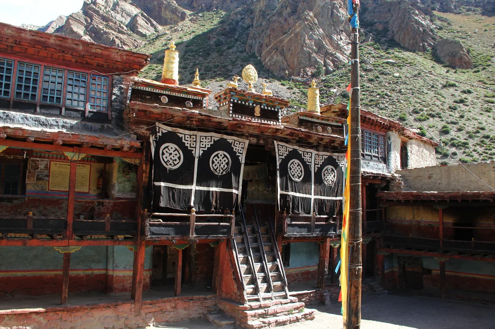
Ảnh: Wang Lama · CC BY-SA 4.0
Hiển thị bằng tiếng Anh — chưa được dịch.
Lịch trình này là bản nháp và chưa được xác minh. Luôn xác nhận các chặng với hướng dẫn viên của bạn.
Written by FindTrekkingPartner teamĐược FindTrekkingPartner team kiểm duyệtCách chúng tôi kiểm duyệtFindTrekkingPartner
Limi Valley Trek là chuyến trek 18 ngày ở vùng Humla của Nepal, leo lên độ cao 4.940 m. Trekker nước ngoài có thể tìm bạn đồng hành cho chuyến này trên FindTrekkingPartner bằng cách đăng chuyến đi kèm ngày đi, ngân sách và tốc độ. Các kết nối được giữ riêng tư cho đến khi cả hai trekker đồng ý, và dịch vụ này miễn phí. Ở mức giá tầm trung, một hướng dẫn viên có giấy phép tốn khoảng 168 USD mỗi người trong 18 ngày khi bốn trekker chia sẻ, so với 672 USD cho một trekker đi một mình. Các mùa đẹp nhất là Apr–Jun, Sep–Nov. Đây là khu vực hạn chế, vì vậy hướng dẫn viên có giấy phép được thuê qua công ty lữ hành đã đăng ký là một phần của giấy phép, và cả nhóm đi theo một giấy phép của công ty. Xác minh lần cuối: 19 tháng 10, 2026. Nguồn: Cục Du lịch Nepal (Nepal Tourism Board), DNPWC, Cục Xuất nhập cảnh.
Nguồn:Department of Immigration, NepalNepal Tourism BoardDepartment of National Parks and Wildlife Conservation
Tìm bạn đồng hành cho Limi Valley Trek
- Tìm bạn đồng hành cho Limi Valley TrekChưa có chuyến đi đang mở
Tổng quan
Khởi hành từ KathmanduĐèo: Nara La, Lamka La, Nyalu La18 ngày · tối đa 4.940 m
Mùa đẹp nhất: Apr–Jun, Sep–Nov · Giấy phép: Humla restricted-area permit (Department of Immigration, via a registered agency), TIMS card issued through a registered agency
The Limi Valley trek is an 18-day loop through the far north-west of Nepal, from Simikot, the district capital of Humla, up the Humla Karnali to Hilsa on the Tibet border and over the Nara La to the three Limi villages of Til, Halji and Jang. It flies from Kathmandu to Nepalgunj and on to Simikot, walks through Dharapuri, Kermi, Yalbang, Tumkot and Yari to Hilsa, crosses the Lamka La to Til, visits Halji and Jang, then takes the long wilderness stages via Talung and the Nyalu La to Shinjungma, returns to Kermi and Simikot, and flies out. The walking covers about 190 km with 8,400 m of climbing, following four operator itineraries. Humla is a restricted area: the Nepal Tourism Board lists the permit at USD 50 per person for the first week, plus USD 10 per day after, through a registered agency, with a licensed guide. The seasons are April to June and September to November, and the flights need spare days.
What the trek is like
The first six days follow the Karnali upstream through pine forest and Tibetan-influenced villages with stone houses and monasteries. After Hilsa the valley opens into the high Limi plateau, with barley fields and juniper, then the three villages. The trek's second half is a remote loop with no villages for two days before Kermi.
Permits and rules
The restricted-area permit is arranged through a registered trekking agency. The Nepal Tourism Board gives the fee as USD 50 per person for the first week and USD 10 per day beyond it. A licensed guide through a registered agency is required. Since 22 March 2026 one trekker can apply, so a group of two is no longer a minimum, but a partner halves the guide cost. A TIMS card is also arranged by the agency.
Best season
April to June and September to November; avoid December to February. Passes need clear weather, and the monsoon brings landslides and flight cancellations.
Altitude
You climb from Simikot at about 2,950 m to Yari at about 3,700 m in four days and cross the Nara La at about 4,620 m. The highest night is Talung at about 4,370 m, below the Nyalu La at about 4,940 m. There are no spare acclimatisation days in this plan, so build one into the Hilsa to Til section or add a day at Jang.
Getting there and away
Fly Kathmandu to Nepalgunj and on to Simikot, then reverse. Flights are often delayed by weather, so keep at least two spare days at the end.
Lodges, food and costs
Facilities are scarce, so the agency supplies the crew, tents and food, with homestays where available. See the costs section for the sourced permit fee and sample costs.
Extensions
You can extend the trek by adding rest days at Jang or Halji, or by continuing from Hilsa towards the Kailash pilgrimage route, which has its own border rules.
Điểm nổi bật
- The Humla Karnali gorge from Simikot to the Tibet border at Hilsa
- Til, Halji and Jang, three Tibetan villages at 3,700 to 4,100 m
- Rinchenling monastery in Halji, a Drikung Kagyu temple
- The Nara La (about 4,620 m) and the Nyalu La (about 4,940 m)
- One of the most remote trekking circuits in Nepal
Bản đồ lộ trình
Dữ liệu lộ trình từ OpenStreetMap, nhóm chúng tôi chưa kiểm tra. Hãy dùng để lên kế hoạch, không dùng để dẫn đường.
Từng ngày
Bạn ngủ cao hơn đêm trước 2.800 m, vượt mức khuyến nghị thông thường là 500 m. Hãy đi chậm, uống nhiều nước và chú ý các dấu hiệu đau đầu hoặc buồn nôn.
Fly from Nepalgunj to Simikot in a small plane, about 40 to 45 minutes over the Churen Himal, landing on the high strip above the town at about 2,900 to 2,950 m. Simikot is the district capital of Humla, with a bazaar, a hospital and a few lodges. Flights are often delayed by wind or cloud, and the day may turn into a wait at the airstrip. Walk around the town, drink water and let the body adjust to the altitude. Your crew will finalise loads for the porters.
The first walk descends from Simikot over a ridge and through forest, passing the village of Majgaon, to Dharapuri at about 2,300 m, near the Humla Karnali. Operators give 4 to 5 hours; our mapped route is about 9 km with a net descent. The path has a short climb to a pass at about 3,000 m, then a long descent. Dharapuri is a lower, warmer village on the river, with fields and a few lodges or camping areas. You will start to hear the Karnali from here on.
Follow the Humla Karnali upstream to Kermi, at about 2,670 m, in about 4 hours and 10 km. The path runs through pine forest, villages and fields, with the river always nearby, though on our mapped route it follows tracks and roads that run along the valley. Kermi is known for its hot springs, so you can soak your legs after the walk. There are lodges and camping places. It is an easy day, so use it to get your pace right and drink well, because the altitude rises quickly over the following days.
Continue up the Karnali, crossing a small pass and a suspension bridge over the Salli river, to Yalbang, at about 3,020 m. Operators give 5 to 6 hours for the 11 km, with about 600 m of climbing. The first Tibetan-style village on the route has stone houses and a gompa. Walk gently, as you gain height quickly; sleeping above 3,000 m, you may feel the first headache. The crew can pitch tents near the village or use basic lodging, and the river valley opens up around you.
Climb gradually to Tumkot, at about 3,380 m, passing farms and rocky slopes on a walk of 5 to 6 hours and about 14 km. Tumkot has the Dhungkar Choezom monastery, mentioned in operator itineraries, and a pleasant setting above the river. Operators sometimes stop at Muchu instead, a shorter walk of about 4 hours that splits the day. The air is dry here and the sun strong, so use sun cream and carry plenty of water, since the slopes give little shade. Keep an eye on how everyone in the group is feeling, as the nights now start above 3,000 m.
Pine gives way to juniper as you climb above 3,500 m, on a walk of 4 to 5 hours and about 14 km to Yari, at about 3,700 m, near the first high-altitude pastures. Some groups camp a little beyond at Thado Dunga, about 30 minutes further. Keep a slow pace, drink often and watch your appetite and sleep. Tomorrow is the first pass, the Nara La, so go to bed early and check that your jacket, hat and gloves are within easy reach for the early start.
Cross the Nara La, at about 4,620 m, in a long day of 6 to 7 hours and about 20 km on our mapped route, with about 860 m of climbing, then descend to Hilsa, at about 3,720 m, on the Tibet border. The pass is the traditional pilgrim route to Mount Kailash. Hilsa sits on the Karnali beside a bridge to Tibet, with a hospital, and the Great Himalaya Trail's Nepal section ends here. Start early to cross before the wind and cloud, and stay close to your guide.
Follow the upper Karnali towards Limi in 5 to 6 hours, on rocky and in places steep ground, to a campsite at Manepeme at about 3,900 m, beside the river. On our mapped route it is 11 km with a gain of about 700 m, with a mix of tracks and road. The valley is wide and treeless, and you are well into Tibetan country: look for prayer flags, mani walls and herders. The camp is cold at night, so layer up, drink warm drinks and keep your water bottle from freezing.
Cross the Lamka La, at about 4,300 m, and enter the Limi valley, then reach Til, the first of the three Limi villages, at about 4,000 m, after about 6 hours and 12 km. Til is a stone-house village among barley fields, with views of the valley. It is the first of three villages in a very remote valley. The crew camps near the village or arranges homestays. Eat well, rest and take it easy on the second night at altitude.
Descend to the Limi river and follow the valley to Halji, the largest Limi village, at about 3,660 m, in about 3 to 4 hours and 9 km. Halji's Rinchenling monastery belongs to the Drikung Kagyu school, and popular accounts date it to the 11th century, although other scholars place it later. Ask your guide to arrange a visit and be respectful: remove your hat and shoes, ask before taking photos and walk clockwise around chortens. You have time in the afternoon to wander the village lanes.
Walk up the valley to Jang, the highest of the three Limi villages, at about 3,930 m, through barley fields and pasture. Operators give 4 hours for the 9.5 km, and Travels with Teri adds an acclimatisation rest day here. Jang has stone houses, a gompa, mani walls and prayer flags, and the sunsets are fine. The next day starts a long remote stretch, so use the afternoon to check your gear, repack and charge devices. You will not see a village again until Kermi.
A long, empty stage of about 8 hours and 17 km climbs to Talung, at about 4,370 m, the highest overnight of the trek. There are no villages until Kermi, so this is the start of a wilderness section. The trail follows the valley across open slopes and passes small herders' camps. Pace yourself and drink often: you sleep above 4,000 m and tomorrow is the hardest day. Use your layers and a warm sleeping bag; frost is common at the camp.
The hardest day: a long climb to the Nyalu La, at about 4,940 to 5,000 m depending on the source, then a long descent to Shinjungma, at about 3,620 m. Operators give about 8 hours; our mapped route is 21 km with about 1,300 m of descent. The pass has wide views of the valleys behind and ahead. Start at first light, carry a packed lunch and check the weather: if a storm or heavy snow threatens, your guide may decide to wait. Descend slowly on the loose ground, using poles to save your knees.
Descend through birch and pine forest to the Karnali valley and the hot springs at Kermi, at about 2,670 m, in about 7 hours and 15 km, mostly downhill. The trail drops almost 1,000 m. You return to lodges and a lower, warmer climate, and the evening soak at Kermi is a reward. If you are tired, take the descent slowly: the knees take a beating. Tonight you are back among villages and fields, and the crew will want a celebration dinner.
Walk back to Simikot in about 6 to 7 hours, a day of about 19 km and 1,100 m of climbing, mostly uphill after Dharapuri. Operators split this day in other itineraries (Kermi to Dharapuri, then Dharapuri to Simikot), which makes for a gentler pace. The trail follows the Karnali downstream, then climbs the ridge past Majgaon to Simikot. Check in at a lodge and reconfirm the flight. Keep your boots and poles handy in case the plane is delayed and you need to fill a day.
Fly from Simikot to Nepalgunj, about 40 to 45 minutes, usually in the morning, weather permitting. If the wind keeps the plane on the ground, your agency can arrange a spare day in Simikot. Flights are the most common cause of delay on this trek. In Nepalgunj you transfer to the hotel, wash and rest, then use the afternoon to book the onward flight to Kathmandu or to sort the paperwork with the agency. The town is hot and dusty after the mountains, so drink plenty of water and enjoy a proper shower and a restaurant meal.
Bạn ngủ cao hơn đêm trước 1.250 m, vượt mức khuyến nghị thông thường là 500 m. Hãy đi chậm, uống nhiều nước và chú ý các dấu hiệu đau đầu hoặc buồn nôn.
Fly from Nepalgunj to Kathmandu, about an hour, and transfer to your hotel. If the Simikot flight ran on schedule, you may be able to take an earlier connection. Back in the capital, hand back any rented gear, settle accounts with the crew and say your thanks, then check that your passport, receipts and permit copies are all in order. Use the evening to eat out, sort photos and rest your legs. If you have a spare day before your international flight, a visit to Patan or Boudhanath will contrast with the remote valleys you have just left.
Thích nghi độ cao
Độ cao nơi ngủ từng đêm. Các cột màu đỏ cao hơn đêm trước hơn 500 m; ngày nghỉ được đánh dấu.
- Độ cao nơi ngủ
- Tăng trên 500 m
- Ngày nghỉ
Chi phí
Chi phí trọn gói ước tính cho mỗi người: nhà trọ và ăn uống theo độ cao, di chuyển, giấy phép, hướng dẫn viên và porter. Càng nhiều người trekking chia chung hướng dẫn viên và porter, mỗi người trả càng ít. Tính đến tháng 10 năm 2026.
| Phong cách | 1 người trekking chia chung | 2 người trekking chia chung | 4 người trekking chia chung |
|---|---|---|---|
| Tiết kiệm | 1.200 US$–1.800 US$* | 990 US$–1.450 US$* | 870 US$–1.250 US$* |
| Tầm trung | 1.550 US$–2.350 US$* | 1.250 US$–1.850 US$* | 1.100 US$–1.650 US$* |
| Thoải mái | 1.750 US$–2.600 US$* | 1.500 US$–2.250 US$* | 1.400 US$–2.050 US$* |
Chia chung hướng dẫn viên, tiết kiệm tiền
Ở mức tầm trung, một người trekking một mình trả khoảng 1.550 US$–2.350 US$; bốn người chia chung một hướng dẫn viên và hai porter trả khoảng 1.100 US$–1.650 US$ mỗi người (rẻ hơn 30% ở đầu trên của khoảng giá).
Chi tiết cho 2 người trekking chia chung
| Khoản mục | Tiết kiệm | Tầm trung | Thoải mái |
|---|---|---|---|
| Nhà trọ và ăn uống | 400 US$–640 US$ | 540 US$–850 US$ | 720 US$–1.100 US$ |
| Di chuyển | 200 US$–290 US$ | 200 US$–290 US$ | 200 US$–290 US$ |
| Giấy phép | 150 US$–160 US$ | 150 US$–160 US$ | 150 US$–160 US$ |
| Hướng dẫn viên | 230 US$–360 US$ | 230 US$–360 US$ | 230 US$–360 US$ |
| Porter | — | 100 US$–180 US$ | 210 US$–360 US$ |
Tiết kiệm dùng phương tiện công cộng và không có porter; tầm trung chia một porter cho hai người trekking và dùng xe riêng; thoải mái cho mỗi người một porter. Hướng dẫn viên được tính khi bắt buộc hoặc khi phong cách là tầm trung hay thoải mái.
Nhà trọ và ăn uống mỗi đêm (phòng và một bữa dal bhat)
3 đêm Below 2,500 m: phòng 2 US$–9 US$, dal bhat 4 US$–7 US$ · 10 đêm 2,500 to 3,800 m: phòng 4 US$–11 US$, dal bhat 5 US$–11 US$ · 4 đêm Above 3,800 m: phòng 7 US$–19 US$, dal bhat 8 US$–13 US$
Phí giấy phép (nguồn chính thức)
Chưa bao gồm
Không tìm thấy giá công bố cho: Nepalgunj to Simikot flight (return). Các tổng có dấu * chưa tính những khoản này; hãy hỏi công ty du lịch của bạn. Đây là chuyến trek cắm trại: đoàn phục vụ, lều và thức ăn do công ty du lịch báo giá. Camping trek: crew, tents, kitchen and food are quoted by the agency and are not in this estimate.
Nguồn chi phí
- PriceNepal: Nepal Travel Cost Guide 2026 (2026-05-14)
- Third Rock Adventures: Nepal trek budget planner (2026-05-09)
- Himalayan Partner: Guide and porter price in Nepal 2026 (2026-02-10)
- Shikhar Adventure: Annapurna Circuit trek cost (2026-02-03)
- Nepal Tourism Board: Trekking Permit (2026-10-18)
Ước tính từ hướng dẫn của nhà điều hành, không phải báo giá. Tiền boa, bảo hiểm, đồ dùng và khách sạn ở Kathmandu không được tính; USD theo tỷ giá của nền tảng.
Ảnh
Câu hỏi thường gặp
Yes. Humla is a restricted area. The Nepal Tourism Board lists USD 50 per person for the first week and USD 10 per day beyond, arranged through a registered agency. Operators also require a licensed guide.
This plan takes 18 days from Kathmandu to Kathmandu: two days of flights at each end, 14 days on foot and no spare day. Most operators allow 18 to 21 days.
Operators give about 4,940 to 4,949 m; one says 5,001 m. The Nara La is about 4,620 m and the Lamka La about 4,300 m.
Not in this plan, although Travels with Teri adds an acclimatisation day at Jang. Add a day at Til or Jang if you can; flight buffer days are separate.
No. Humla is a restricted area and a licensed guide and a registered agency are required. Since 22 March 2026 one trekker can apply, so you no longer need a group of two, but a partner halves the guide cost.
No. It is a long, remote route with passes above 4,600 m, 14 walking days and slow evacuation. Experience of multi-week high-altitude trekking is expected.
Nguồn
Dọc đường mòn
Chỗ ở, hỗ trợ y tế, nước và cảnh đẹp trong mỗi ngày của lộ trình.
1. Kathmandu → Nepalgunj
- Tribhuvan International Airport · Sân bay & giao thông · 1.340 m
Show all 2 places
- Tribhuvan International Airport · Sân bay & giao thông · 1.340 m
- Nepalgunj Airport · Sân bay & giao thông · 165 m
2. Nepalgunj → Simikot
- Simikot Airport · Sân bay & giao thông · 2.818 m
Show all 2 places
- Simikot Airport · Sân bay & giao thông · 2.818 m
- Simikot Airpot Helipad · Sân bay & giao thông · 2.971 m
3. Simikot → Dharapuri
- Humla District Hospital · Y tế · 2.937 m
- Laxmi Aayurbedic Medical Hall · Y tế · 2.949 m
- Hotel Panchamukhi · Chỗ ở · 2.981 m
- Hotel Mansarovar · Chỗ ở · 2.986 m
- Water_tap · Tiện ích · 3.036 m
- Raling hotel · Chỗ ở · 2.990 m
- Drinking Water · Tiện ích · 3.265 m
- Namaste Shahi Hotel · Chỗ ở · 2.343 m
Show all 13 places
- Hotel Panchamukhi · Chỗ ở · 2.981 m
- Laxmi Aayurbedic Medical Hall · Y tế · 2.949 m
- Kishan Micro Finance · Tiện ích · 2.992 m
- Hotel Mansarovar · Chỗ ở · 2.986 m
- Humla District Hospital · Y tế · 2.937 m
- Water_tap · Tiện ích · 3.036 m
- Raling hotel · Chỗ ở · 2.990 m
- SB Hotel · Chỗ ở · 2.995 m
- Sunny Guest House · Chỗ ở · 3.006 m
- Sun Valley Resort Hotel · Chỗ ở · 3.022 m
- Drinking Water · Tiện ích · 3.265 m
- Manshorowar Shari Hotel · Chỗ ở · 2.483 m
- Namaste Shahi Hotel · Chỗ ở · 2.343 m
4. Dharapuri → Kermi
- Tarku Khola Hotel · Chỗ ở · 2.414 m
- Teahouse · Chỗ ở · 2.490 m
- Kalakaghun Hotel [extremely basic - 2026] · Chỗ ở · 2.478 m
5. Kermi → Yalbang
- Kermi Camp Side · Chỗ ở · 2.795 m
6. Yalbang → Tumkot
- Drinking Water · Tiện ích · 2.980 m
- Riverside Hotel · Chỗ ở · 3.088 m
- Homestay Yalbang · Chỗ ở · 3.082 m
- Namkhyung Mahamaya Basic School Playground · Sân bay & giao thông · 3.118 m
- Humla Himalyan Hotel - [lot of drunk people] · Chỗ ở · 3.125 m
7. Tumkot → Yari
- Drinking Water · Tiện ích · 3.182 m
- Yari Hotel · Chỗ ở · 3.784 m
8. Yari → Hilsa
- Himalaya Guest House · Chỗ ở · 3.786 m
- Hotel Snow Lion · Chỗ ở · 3.643 m
- Special Health Camp · Y tế · 3.632 m
- Hilsa Hospital · Y tế · 3.639 m
- Khang Jong Limi Hotel · Chỗ ở · 3.638 m
9. Hilsa → Manepeme
- Hotel Manasovar Restaurant and Bar · Chỗ ở · 3.633 m
- Sange Hotel and Lodge · Chỗ ở · 3.630 m
- Himalaya Hotel, Restaurant and Bar · Chỗ ở · 3.632 m
10. Manepeme → Til
- On the way to Hilsha from Til · Điểm ngắm cảnh · 4.265 m
- Drinking Water · Tiện ích · 3.933 m
11. Til → Halji
- Drinking Water · Tiện ích · 3.930 m
12. Halji → Jang
- Drinking Water · Tiện ích · 3.732 m
13. Jang → Talung
- Limi Resort, Tokche, Tumling · Chỗ ở · 4.179 m
- Selima Tso · Thiên nhiên · 4.259 m
14. Talung → Shinjungma
Chưa có gì được vẽ trên bản đồ cho ngày này.Chưa có gì được vẽ trên bản đồ cho ngày này.15. Shinjungma → Kermi
- Salli Lodge and Restaurant · Chỗ ở · 2.975 m
16. Kermi → Simikot
- Drinking Water · Tiện ích · 2.373 m
- Dharapori Hotel [Open - 2026] · Chỗ ở · 2.342 m
- Sunshine Medical Hospital · Y tế · 2.955 m
- Simikot lagna · Điểm ngắm cảnh · 3.233 m
- Hotel Bijaya · Chỗ ở · 3.011 m
- Kailash - 2026 · Chỗ ở · 3.009 m
- CFD Humla · Chỗ ở · 3.015 m
- Health Us Nepal Medical Center · Y tế · 2.961 m
Show all 11 places
- Chyachhara Jharna · Thiên nhiên · 2.456 m
- Drinking Water · Tiện ích · 2.373 m
- Dharapori Hotel [Open - 2026] · Chỗ ở · 2.342 m
- Manshorowar Shahi Hotel - 2026 · Chỗ ở · 2.499 m
- Sunshine Medical Hospital · Y tế · 2.955 m
- Dada Hotel · Chỗ ở · 3.271 m
- Simikot lagna · Điểm ngắm cảnh · 3.233 m
- Hotel Bijaya · Chỗ ở · 3.011 m
- Kailash - 2026 · Chỗ ở · 3.009 m
- CFD Humla · Chỗ ở · 3.015 m
- Health Us Nepal Medical Center · Y tế · 2.961 m
17. Simikot → Nepalgunj
Chưa có gì được vẽ trên bản đồ cho ngày này.Chưa có gì được vẽ trên bản đồ cho ngày này.18. Nepalgunj → Kathmandu
Chưa có gì được vẽ trên bản đồ cho ngày này.Chưa có gì được vẽ trên bản đồ cho ngày này.
Xác minh lần cuối ngày 19 thg 10, 2026Báo cáo thông tin lỗi thời