

Leave Kathmandu early for the drive north to Syabrubesi, at about 1,500 m, on the Trisuli road past Trisuli Bazaar and the approach to Langtang. Operators give 6 to 9 hours depending on the vehicle and the state of the road; the bus is slower and cheaper than a jeep. The road is narrow and winding, with some landslide sections. Syabrubesi is the busy start of the Langtang and Tamang Heritage routes, so you will see other trekkers. Check in to a lodge, confirm your permit paperwork with the guide, pack a daypack and have an early night before the first walking day.
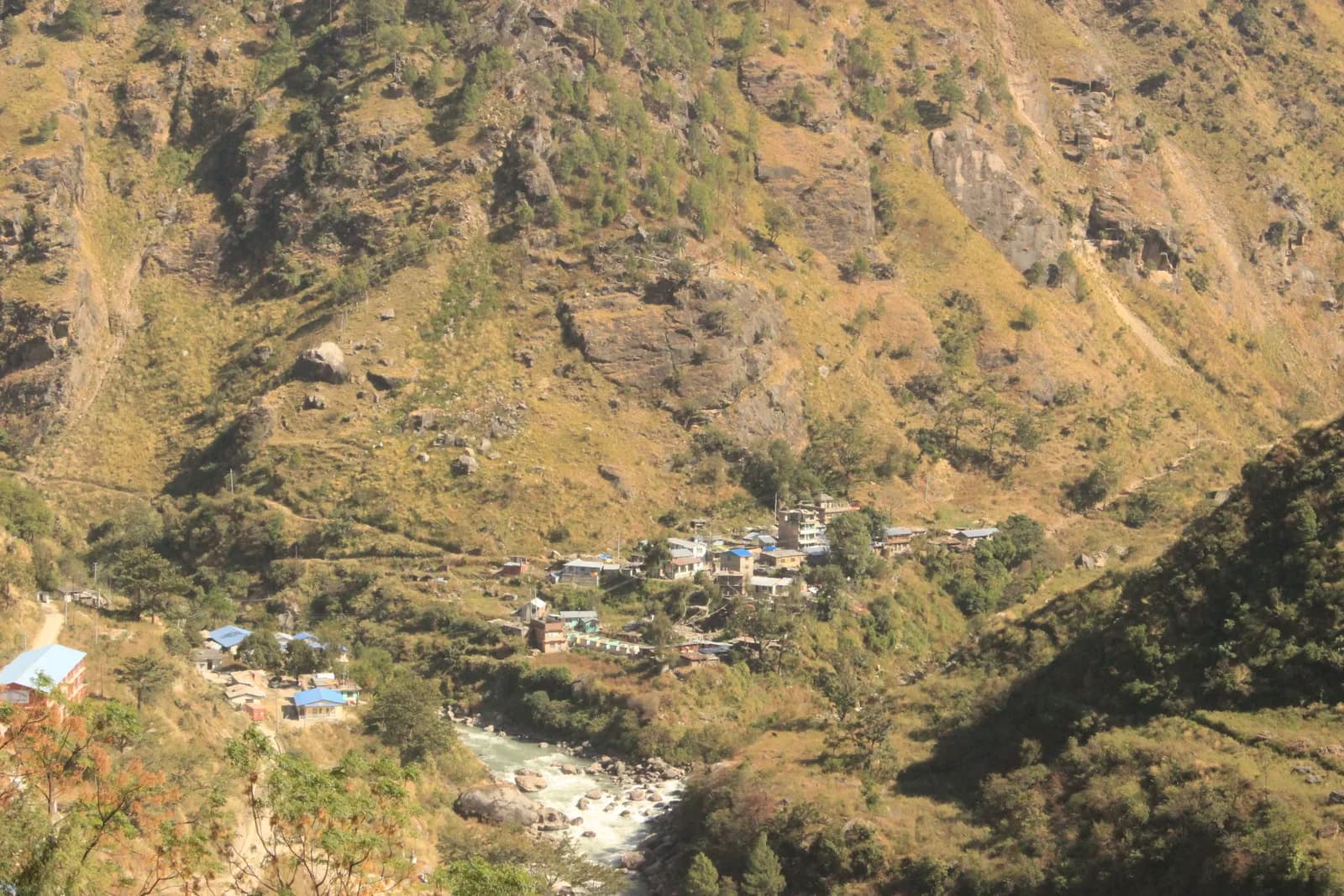
Ruby Valley and Ganesh Himal Trek
A 7-day village trek from Syabrubesi over Pangsang Pass to Tipling and Chalish, with a rest day around Chalish and a drive back through Dhading Besi.
- Ngày7
- Độ cao tối đa3.850 m
- Quãng đường43,7 km
- Độ cao leo3.638 m
- Độ khóTrung bình
- Tháng đẹp nhấtMar–May, Oct–Nov
- Giấy phép2
Lên kế hoạch chuyến đi theo lịch trình nàyTìm bạn đồng hành cho Ruby Valley and Ganesh Himal TrekXem lịch khởi hành theo tuần
Ảnh: Rajivkilanashrestha · CC BY-SA 4.0
Cảnh báoRuby Valley: the Syabrubesi start is not currently reliable
This route drives to Syabrubesi on day 1 and finishes at Chalish with a drive back through Dhading Besi. On 26 August 2026 a large rock-and-ice collapse from the north face of Langtang Lirung sent a debris flow down the Lhende Khola into the Bhote Koshi and Trishuli rivers, hitting Rasuwagadhi, Timure, Syabrubesi and Betrawati (ICIMOD). Many bridges and long stretches of the Pasang Lhamu Highway were damaged, and a large number of people died or are missing; reported figures differ by source.
Syabrubesi, the usual Langtang road-head, is reported destroyed or closed as a trekking gateway, with the bridge to it swept away; restoration depends on the Betrawati highway reopening. The Trishuli Bazaar-Betrawati-Dhunche road was reported still closed for repair as of 21 September. A light-vehicle track has reopened, and agencies projected the remaining gaps passable no earlier than mid-October; that is a projection, not an official date.
We found no source on the condition of the Ruby Valley trail itself or a reopening date. We found no official reopening notice. Check current road and trail conditions with Langtang National Park and your trekking agency before booking, and do not rely on this summary alone.
Tình trạng được kiểm tra 2026-10-19.
Nguồn: ICIMOD: Kyirong-Rasuwa flood, 26 August 2026 · Nepal Pyramids: Langtang Valley trek update after the 2026 flooding · Republica: locals reopen flood-damaged Langtang trekking route (16 Oct)
Hiển thị bằng tiếng Anh — chưa được dịch.
Lịch trình này là bản nháp và chưa được xác minh. Luôn xác nhận các chặng với hướng dẫn viên của bạn.
Written by FindTrekkingPartner teamĐược FindTrekkingPartner team kiểm duyệtCách chúng tôi kiểm duyệtFindTrekkingPartner
Ruby Valley and Ganesh Himal Trek là chuyến trek 7 ngày ở vùng Ganesh Himal của Nepal, leo lên độ cao 3.850 m. Trekker nước ngoài có thể tìm bạn đồng hành cho chuyến này trên FindTrekkingPartner bằng cách đăng chuyến đi kèm ngày đi, ngân sách và tốc độ. Các kết nối được giữ riêng tư cho đến khi cả hai trekker đồng ý, và dịch vụ này miễn phí. Ở mức giá tầm trung, một hướng dẫn viên có giấy phép tốn khoảng 65 USD mỗi người trong 7 ngày khi bốn trekker chia sẻ, so với 261 USD cho một trekker đi một mình. Các mùa đẹp nhất là Mar–May, Oct–Nov. Trên thực tế, ở đây bắt buộc có hướng dẫn viên có giấy phép: theo các nhà điều hành năm 2026, quy định tháng 4 năm 2023 của Cục Du lịch Nepal (Nepal Tourism Board) được thực thi tại các trạm kiểm soát ở vườn quốc gia và khu bảo tồn, trong đó Langtang nghiêm ngặt nhất và Annapurna cũng kiểm tra (kiểm tra ngày 19 tháng 10 năm 2026). Hãy thuê hướng dẫn viên qua công ty lữ hành đã đăng ký và xác nhận với họ. Xác minh lần cuối: 19 tháng 10, 2026. Nguồn: Cục Du lịch Nepal (Nepal Tourism Board), DNPWC, Cục Xuất nhập cảnh.
Nguồn:Department of Immigration, NepalNepal Tourism BoardDepartment of National Parks and Wildlife Conservation
Tìm bạn đồng hành cho Ruby Valley and Ganesh Himal Trek
- Tìm bạn đồng hành cho Ruby Valley and Ganesh Himal TrekChưa có chuyến đi đang mở
Tổng quan
Khởi hành từ KathmanduĐèo: Pangsang Pass7 ngày · tối đa 3.850 m
Mùa đẹp nhất: Mar–May, Oct–Nov · Giấy phép: Langtang National Park entry permit, TIMS card where required
The Ruby Valley trek is a seven-day walk through the villages and forests on the south-west side of Ganesh Himal. It drives from Kathmandu to Syabrubesi, the Langtang trailhead, walks over Bahun Danda to the Tamang village of Gatlang, climbs to the forest camp at Somdang (about 3,270 m), crosses Pangsang Pass at about 3,850 m and descends to Tipling, then walks through the Tamang village of Sertung to Chalish, with a rest day around Chalish for Sertung and the Tatopani hot spring before a drive back to Kathmandu via Dhading Besi. The walking adds up to about 44 km on our mapped route with roughly 3,600 m of climbing, following the stages of the Nepal Alternative Treks, Himalaya Trip and Peregrine itineraries in the sources. It is a moderate trek, needs the Langtang National Park permit and no restricted-area permit, and runs best from late September to early December and in spring.
What the trek is like
The first day on foot climbs from the Bhote Koshi valley through forest to Bahun Danda and on to Gatlang, a village of dark stone houses at about 2,300 m. The next two days go up into pine and rhododendron forest to Somdang and over Pangsang Pass, where on clear days Ganesh Himal fills the northern horizon. The final descent leads through millet and maize terraces to Tipling and Chalish, villages where local families run homestays.
Permits and rules
The Langtang National Park entry permit is NPR 3,000 for foreigners (Nepal Tourism Board). A TIMS card is listed by some operators. The trek is not in a restricted area, so there is no minimum group size, but trails above Somdang are quiet, so most people go with a guide.
Best season
Mid-September to mid-December and March to May. Monsoon trails are slippery and leech-prone.
Altitude
The highest overnight is Somdang at about 3,270 m and the pass is about 3,850 m, so most people feel the height only as a little breathlessness. Walk slowly and drink well.
Getting there and away
Kathmandu to Syabrubesi is 6 to 9 hours by road, and Chalish to Kathmandu about 8 hours via Dhading Besi. Plan one spare day if road works or landslides are reported.
Lodges, food and costs
Homestays and simple guesthouses serve dal bhat. See the permit fees and sample costs in the costs section.
Extensions
Operators extend the trek with an acclimatisation day at Somdang, a walk on to Jharlang and Darkha, or a longer circuit through Hindung to Ganesh Himal Base Camp, which has no lodges.
Điểm nổi bật
- Gatlang, a Tamang village of stone houses and pilgrim lake
- Somdang, a forest camp at about 3,270 m below Ganesh Himal
- Pangsang Pass at about 3,850 m, with views of the Ganesh Himal range
- Tipling and Chalish, farming villages with homestays and the Tatopani hot spring nearby
- A moderate trek with no restricted-area permit
Bản đồ lộ trình
Dữ liệu lộ trình từ OpenStreetMap, nhóm chúng tôi chưa kiểm tra. Hãy dùng để lên kế hoạch, không dùng để dẫn đường.
Từng ngày
Bạn ngủ cao hơn đêm trước 834 m, vượt mức khuyến nghị thông thường là 500 m. Hãy đi chậm, uống nhiều nước và chú ý các dấu hiệu đau đầu hoặc buồn nôn.
Cross to the west bank of the Bhote Koshi and climb through forest and farmland over Bahun Danda to Gatlang, at about 2,300 m. Operators allow 4 to 6 hours for the 11 km, and the gain is about 1,060 m. Gatlang is a Tamang village of stone houses, wooden balconies and prayer flags, with a pilgrim lake nearby. Walk through the lanes in the afternoon, and be respectful when entering temples or taking photos of people. Homestay families cook dal bhat and local food. The altitude is modest, but drink a lot and climb slowly.
Bạn ngủ cao hơn đêm trước 934 m, vượt mức khuyến nghị thông thường là 500 m. Hãy đi chậm, uống nhiều nước và chú ý các dấu hiệu đau đầu hoặc buồn nôn.
A long day of 6 to 7 hours takes you from Gatlang to Somdang, at about 3,270 m, climbing about 1,500 m over 12.6 km. The trail goes through dense pine and rhododendron forest, passing Khurpu Bhanjyang, a saddle of about 3,700 m on the map, before the final stretch to Somdang. The hamlet has a few guesthouses on a clearing with views down the valley. It is the highest night of the trek, so go slowly, eat well and wrap up in the evening, when the air turns cold quickly.
The hardest day: leave early and climb above the tree line to Pangsang Pass, at about 3,850 m, where the views take in the Ganesh Himal range on a clear morning. Then descend steeply through forest to Tipling, at about 2,000 m, a drop of about 1,800 m from the pass over 15 km on our mapped route. Operators allow 7 to 8 hours in total, and some call it 8 to 10, so start at first light and carry lunch. Poles are a great help on the knee-jarring descent. Tipling's homestays give a welcome rest at the end.
Walk down from Tipling through millet and maize terraces to Sertung, a Tamang village, and on to Chalish Gaon at about 1,675 m. Operators give 3 to 5 hours for the day, depending on how long you spend among the Sertung houses. Our map follows the footpath through Sertung: 4.7 km with about 360 m of climbing and 690 m of descent, so the day is short on distance but has a lot of up and down. One operator counts 12 km for the same day because it also visits upper villages that OpenStreetMap does not map. Stop in Sertung for tea, then continue to Chalish, home to Gurung, Ghale and Kami families, where the lower altitude and warmer evenings make a pleasant place to rest.
A rest day around Chalish with an optional walk of about 4 to 5 hours: operators suggest a round trip to Sertung, a viewpoint, and the Tatopani hot spring, where you can soak tired legs. The route is gentle and mostly on village paths, and you can shorten it or skip it. Ask your host about a cultural evening if you want music and dance, usually arranged on request. This is also the sensible day to wash clothes, back up photos and repack for the road, because the last day is a long drive.
Drive from Chalish via Dhading Besi to Kathmandu, a journey of about 8 hours on the Dhading and Prithvi roads. Operators quote between 7 and 9 hours with a mix of private jeep and bus; the stretch to Dhading Besi is rough and slow, and the rest is on tarmac. Leave early, take snacks and water, and keep a spare day in your plans if the monsoon or road works are reported. Back in Kathmandu, hand back any rented gear and settle up with the guide and drivers.
Thích nghi độ cao
Độ cao nơi ngủ từng đêm. Các cột màu đỏ cao hơn đêm trước hơn 500 m; ngày nghỉ được đánh dấu.
- Độ cao nơi ngủ
- Tăng trên 500 m
- Ngày nghỉ
Chi phí
Chi phí trọn gói ước tính cho mỗi người: nhà trọ và ăn uống theo độ cao, di chuyển, giấy phép, hướng dẫn viên và porter. Càng nhiều người trekking chia chung hướng dẫn viên và porter, mỗi người trả càng ít. Tính đến tháng 10 năm 2026.
| Phong cách | 1 người trekking chia chung | 2 người trekking chia chung | 4 người trekking chia chung |
|---|---|---|---|
| Tiết kiệm | 340 US$–430 US$ | 240 US$–330 US$ | 190 US$–280 US$ |
| Tầm trung | 770 US$–1.150 US$ | 470 US$–700 US$ | 340 US$–510 US$ |
| Thoải mái | 820 US$–1.200 US$ | 560 US$–830 US$ | 430 US$–650 US$ |
Chia chung hướng dẫn viên, tiết kiệm tiền
Ở mức tầm trung, một người trekking một mình trả khoảng 770 US$–1.150 US$; bốn người chia chung một hướng dẫn viên và hai porter trả khoảng 340 US$–510 US$ mỗi người (rẻ hơn 55% ở đầu trên của khoảng giá).
Chi tiết cho 2 người trekking chia chung
| Khoản mục | Tiết kiệm | Tầm trung | Thoải mái |
|---|---|---|---|
| Nhà trọ và ăn uống | 100 US$–170 US$ | 130 US$–230 US$ | 190 US$–300 US$ |
| Di chuyển | 100 US$–130 US$ | 150 US$–220 US$ | 150 US$–220 US$ |
| Giấy phép | 30 US$–40 US$ | 30 US$–40 US$ | 30 US$–40 US$ |
| Hướng dẫn viên | — | 100 US$–160 US$ | 100 US$–160 US$ |
| Porter | — | 30 US$–70 US$ | 70 US$–130 US$ |
Tiết kiệm dùng phương tiện công cộng và không có porter; tầm trung chia một porter cho hai người trekking và dùng xe riêng; thoải mái cho mỗi người một porter. Hướng dẫn viên được tính khi bắt buộc hoặc khi phong cách là tầm trung hay thoải mái.
Nhà trọ và ăn uống mỗi đêm (phòng và một bữa dal bhat)
5 đêm Below 2,500 m: phòng 2 US$–9 US$, dal bhat 4 US$–7 US$ · 1 đêm 2,500 to 3,800 m: phòng 4 US$–11 US$, dal bhat 5 US$–11 US$
Phí giấy phép (nguồn chính thức)
Nguồn chi phí
- PriceNepal: Nepal Travel Cost Guide 2026 (2026-05-14)
- Third Rock Adventures: Nepal trek budget planner (2026-05-09)
- Himalayan Partner: Guide and porter price in Nepal 2026 (2026-02-10)
- Shikhar Adventure: Annapurna Circuit trek cost (2026-02-03)
- Nepal Tourism Board: Trekking Permit (2026-10-18)
- Mount Mania: Ruby Valley trek (2026-10-18)
Ước tính từ hướng dẫn của nhà điều hành, không phải báo giá. Tiền boa, bảo hiểm, đồ dùng và khách sạn ở Kathmandu không được tính; USD theo tỷ giá của nền tảng.
Ảnh
Câu hỏi thường gặp
It is a moderate trek of 7 days with one hard day, Somdang to Tipling, of 7 to 8 hours over Pangsang Pass. The highest night is about 3,270 m.
Operators list the Langtang National Park entry permit, which the Nepal Tourism Board puts at NPR 3,000 for foreigners. It is not a restricted area.
It suits fit first-timers who are used to 5 to 8 hour days. The altitude is modest, but lodging is basic homestays and the trails are quieter than the main circuits.
By road: operators allow about 8 hours from Chalish via Dhading Besi to Kathmandu, by private jeep or a mix of jeep and bus.
Operators offer an 11 to 12 day circuit that adds Hindung and the base camp, but there are no hotels at the base camp, so it needs camping support.
Nguồn
- Ruby Valley Trek 7 days (Nepal Alternative Treks)
- Ruby Valley Trek (Himalaya Trip)
- Ruby Valley Trek (Peregrine Treks)
- Ruby Valley Trek 10 days (Mount Mania)
- Ganesh Himal (Wikipedia)
- Nepal Tourism Board: Park Entry Fees
- Ruby Valley Home Stay Trek (Himalayan Local Guide)
- Sirtung (Sertung), Dhading (Wikipedia)
Dọc đường mòn
Chỗ ở, hỗ trợ y tế, nước và cảnh đẹp trong mỗi ngày của lộ trình.
1. Kathmandu → Syabrubesi
- Tribhuvan International Airport · Sân bay & giao thông · 1.340 m
2. Syabrubesi → Gatlang
- Temple · Điểm ngắm cảnh · 2.323 m
- Ronga Bhaniyan · Thiên nhiên · 2.240 m
- Tamang Home · Chỗ ở · 2.358 m
- Pador Peak Guest House · Chỗ ở · 2.343 m
- Stone Woodland Guest House · Chỗ ở · 2.302 m
- Langtang View Guest House · Chỗ ở · 2.268 m
Show all 10 places
- Temple · Điểm ngắm cảnh · 2.323 m
- Bagung view point Hotel & Lodge · Chỗ ở · 2.243 m
- Goljung Danda Chhamgang Hotel & Lodge · Chỗ ở · 2.243 m
- Ronga Bhaniyan · Thiên nhiên · 2.240 m
- Unique Lunch Place with Home Stay · Chỗ ở · 2.293 m
- Gyalbo Guest House · Chỗ ở · 2.314 m
- Tamang Home · Chỗ ở · 2.358 m
- Pador Peak Guest House · Chỗ ở · 2.343 m
- Stone Woodland Guest House · Chỗ ở · 2.302 m
- Langtang View Guest House · Chỗ ở · 2.268 m
3. Gatlang → Somdang
- Langatang View Guest House · Chỗ ở · 2.267 m
- Gatlang guest house · Chỗ ở · 2.323 m
- Royal Gatlang Guest House · Chỗ ở · 2.334 m
- Parvati Kund · Thiên nhiên · 2.600 m
- Somdang Valley Lodge · Chỗ ở · 3.276 m
Show all 8 places
- Langatang View Guest House · Chỗ ở · 2.267 m
- Gatlang guest house · Chỗ ở · 2.323 m
- Royal Gatlang Guest House · Chỗ ở · 2.334 m
- Hotel Zeppa · Chỗ ở · 2.336 m
- Parvati Kund · Thiên nhiên · 2.600 m
- Parbati Kunda Guest House · Chỗ ở · 2.655 m
- Ruby Valley Guest House & Homestay · Chỗ ở · 2.673 m
- Somdang Valley Lodge · Chỗ ở · 3.276 m
4. Somdang → Tipling
- Trail to Guesthouses · Điểm ngắm cảnh · 2.244 m
- Ashok Ruby Valley Homestay · Chỗ ở · 2.224 m
- Tipling Homestay · Chỗ ở · 2.216 m
- Ruby Valley Tipling Hotel · Chỗ ở · 2.238 m
- Edwin Tamang Homestay · Chỗ ở · 2.050 m
5. Tipling → Chalish
- Ganesh Himal Hotel · Chỗ ở · 1.936 m
- Healthpost · Y tế · 1.990 m
6. Chalish
Chưa có gì được vẽ trên bản đồ cho ngày này.Chưa có gì được vẽ trên bản đồ cho ngày này.7. Chalish → Kathmandu
Chưa có gì được vẽ trên bản đồ cho ngày này.Chưa có gì được vẽ trên bản đồ cho ngày này.
Xác minh lần cuối ngày 19 thg 10, 2026Báo cáo thông tin lỗi thời