

Fly from Kathmandu to Nepalgunj, a flight of about an hour south-west to the hot Terai plains. Nepalgunj is the hub for far-west Nepal, close to the Indian border, and it is often very hot. Transfer to your hotel and use the afternoon to sort permits, pack and rest. Flights to Juphal leave early in the morning and depend on the weather, so avoid a tight schedule. Check the forecast with your agency, drink plenty of water and have an early night. The next flight is the doorway to Dolpo.
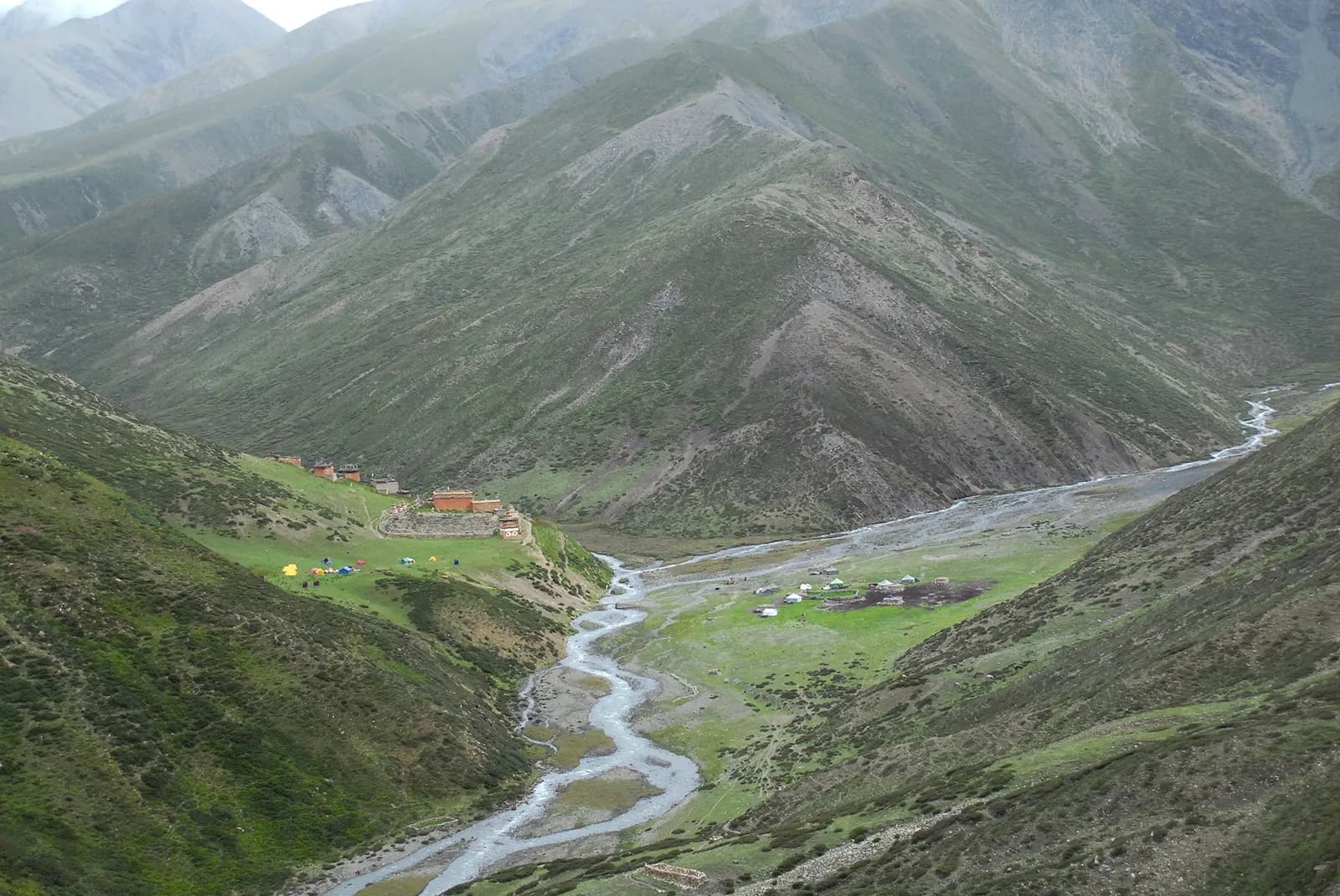
Upper Dolpo: Shey Phoksundo to Shey Gompa
A 22-day restricted-area circuit from Juphal to Phoksundo Lake, over the Kang La to Shey Gompa and Saldang, over the Jeng La to Dho Tarap, and out through Tarakot and Dunai.
- Ngày22
- Độ cao tối đa5.360 m
- Quãng đường225 km
- Độ cao leo10.714 m
- Độ khóKhó
- Tháng đẹp nhấtMay–Jun, Sep–Oct
- Giấy phép3
Lên kế hoạch chuyến đi theo lịch trình nàyTìm bạn đồng hành cho Upper Dolpo: Shey Phoksundo to Shey GompaXem lịch khởi hành theo tuần
Ảnh: Sergey Pashko · CC BY 3.0
Hiển thị bằng tiếng Anh — chưa được dịch.
Lịch trình này là bản nháp và chưa được xác minh. Luôn xác nhận các chặng với hướng dẫn viên của bạn.
Written by FindTrekkingPartner teamĐược FindTrekkingPartner team kiểm duyệtCách chúng tôi kiểm duyệtFindTrekkingPartner
Upper Dolpo: Shey Phoksundo to Shey Gompa là chuyến trek 22 ngày ở vùng Dolpo của Nepal, leo lên độ cao 5.360 m. Trekker nước ngoài có thể tìm bạn đồng hành cho chuyến này trên FindTrekkingPartner bằng cách đăng chuyến đi kèm ngày đi, ngân sách và tốc độ. Các kết nối được giữ riêng tư cho đến khi cả hai trekker đồng ý, và dịch vụ này miễn phí. Ở mức giá tầm trung, một hướng dẫn viên có giấy phép tốn khoảng 205 USD mỗi người trong 22 ngày khi bốn trekker chia sẻ, so với 821 USD cho một trekker đi một mình. Các mùa đẹp nhất là May–Jun, Sep–Oct. Đây là khu vực hạn chế, vì vậy hướng dẫn viên có giấy phép được thuê qua công ty lữ hành đã đăng ký là một phần của giấy phép, và cả nhóm đi theo một giấy phép của công ty. Xác minh lần cuối: 19 tháng 10, 2026. Nguồn: Cục Du lịch Nepal (Nepal Tourism Board), DNPWC, Cục Xuất nhập cảnh.
Nguồn:Department of Immigration, NepalNepal Tourism BoardDepartment of National Parks and Wildlife Conservation
Tìm bạn đồng hành cho Upper Dolpo: Shey Phoksundo to Shey Gompa
- Tìm bạn đồng hành cho Upper Dolpo: Shey Phoksundo to Shey Gompa1 chuyến đi đang mở
- Tìm bạn đồng hành cho Phoksundo Lake Trek (Lower Dolpo)3 chuyến đi đang mở
Tổng quan
Khởi hành từ KathmanduĐèo: Kang La (Nangdalo La), Saldang La, Jeng La22 ngày · tối đa 5.360 m
Mùa đẹp nhất: May–Jun, Sep–Oct · Giấy phép: Upper Dolpo restricted area permit (Department of Immigration, via a registered agency), Shey Phoksundo National Park entry permit, TIMS card where required
This 22-day circuit crosses Dolpo from Phoksundo Lake to Shey Gompa, the Crystal Mountain monastery, on to Namgung and Saldang in the heart of Upper Dolpo, then over the Jeng La to Dho Tarap and out through Tarakot and Dunai. It flies from Kathmandu to Nepalgunj and on to Juphal, walks through Dunai and Chhepka to Ringmo and the turquoise lake at about 3,610 m, climbs to Lar Tsa, crosses the Kang La at about 5,360 m and descends to Shey Gompa at about 4,360 m. The route covers about 270 km on foot with a gain of roughly 12,000 m, following the stages of the operator itineraries in the sources. Upper Dolpo is a restricted area, so you need a Restricted Area Permit through a registered agency, the national park permit and a licensed guide, and most nights are in tents. It is a hard, remote trek. The best months are May and June, and September and October. Allow spare days for the flights.
What the trek is like
From Juphal, the trail follows the Thuli Bheri river to Dunai, the district headquarters, then enters the national park at Sulighat and climbs through blue pine and birch forest to Chhepka and Ringmo. The lake is the highlight of the first week, with a waterfall, chortens and a Bon monastery. North of Phoksundo the landscape turns dry and treeless, and the path climbs to Lar Tsa and over the Kang La, then drops to Shey Gompa beside the Crystal Mountain. Beyond Shey, a high crossing leads to Namgung and Saldang, the largest village of Upper Dolpo, with flat-roofed stone houses, barley fields and a wide plateau. The Jeng La then drops you into the Tarap valley at Dho Tarap, and a long river descent through Khanigaon and Tarakot returns to Dunai.
Highlights
- Phoksundo Lake, a 494-hectare Ramsar lake with a waterfall of about 167 m
- The Kang La, with views of the Kanjiroba range and the Dolpo ranges
- Shey Gompa, an 11th-century Kagyu monastery beside the Crystal Mountain
- Saldang and Namgung, with Tibetan-style houses, chortens and barley terraces
- The Jeng La and Dho Tarap, a walled village in the Tarap valley
Permits and rules
Upper Dolpo needs a Restricted Area Permit from the Department of Immigration, applied for through a registered trekking agency, and the Shey Phoksundo National Park entry permit. The restricted-area permit is charged by the number of days spent in the area, so ask the agency for the current amounts and check them with the Department of Immigration. A licensed guide is compulsory, and most itineraries use camping and a cook. Carry passport copies and permits for the check posts at Juphal and Sulighat.
Best season
May and June, and September and October are the best months. Dolpo lies in the rain shadow, so July and August are drier than in most of Nepal, but cloud over Nepalgunj can ground flights. The Kang La is often snowbound before May and after early November. Winter is very cold and the high villages are empty.
Altitude
The plan reaches Ringmo at about 3,640 m on day 4, with a rest day, then Lar Tsa at about 3,740 m, and Shey at about 4,360 m after the Kang La at about 5,360 m. The saddle between Shey and Namgung reaches about 5,100 m and the Jeng La about 5,100 to 5,124 m, according to OpenStreetMap, and sources quote figures from 5,090 to 5,200 m. The Kang La day is long, with 1,600 m of climbing. Watch for headache, nausea and poor sleep, never ascend with symptoms, and descend if they worsen. Rescue in Upper Dolpo can take a full day, so ascend slowly.
Getting there and away
Fly Kathmandu to Nepalgunj (about an hour) and then to Juphal on a small plane (about 40 minutes). The return reverses this. Flights depend on weather and are often delayed, so keep two spare days in your schedule. There is no road to Phoksundo or Upper Dolpo.
Lodges, food and costs
Lodges operate at Dunai, Chhepka and Ringmo, but in Upper Dolpo most groups camp, using a cook and kitchen tent, with local homestays at Saldang and Namgung. Food is carried in, so costs are higher than on lodge treks, and the permits and flights add more. Bring cash for the whole trek, because there are no machines beyond Dunai.
Packing list
Broken-in boots, waterproof layers, a down jacket, a sleeping bag rated to about minus 15 C, gloves, a warm hat, sun hat, sunglasses, lip balm, gaiters, trekking poles, a headlamp, water purification and a first-aid kit. A trekking umbrella helps in sun and rain.
Who this trek suits and how to prepare
The trek suits fit, experienced trekkers who are comfortable with camping and a few nights above 4,000 m. Prepare with long hill walks with a loaded pack and some altitude experience. The distances are long, and several days run 8 to 10 hours.
The plan at a glance
Days 1 and 2 fly to Nepalgunj and Juphal. Days 3 and 4 walk to Chhepka and Ringmo, with a rest day on day 5. Days 6 and 7 go to Lar Tsa and over the Kang La to Shey, with a rest day on day 8. Days 9 and 10 cross to Namgung and Saldang, with a rest on day 11. Days 12 to 14 go to Rakyo, the Jeng La Phedi camp and over the Jeng La to Dho Tarap, with a rest on day 15. Days 16 to 20 descend through Lahini, Khanigaon, Tarakot and Dunai to Juphal, and days 21 and 22 fly back to Kathmandu.
Extensions
A shorter version returns from Saldang the way you came, over the Kang La, saving about a week. You can also visit Yangtser Gompa from Saldang, add the Numa La and Baga La route from Dho Tarap to Phoksundo, or add rest days to ease the flight schedule.
Practical tips from the trail
- Start early on the Kang La day, with food, water and warm layers in your day bag.
- Keep spare days for the Juphal flights, which are often delayed.
- Walking times in the day plan are estimates from distance and climb; operators quote different hours, and the Kang La, Jeng La and Tarap valley days run long.
- Carry sun protection: the plateau is bright and dry.
- Respect monasteries and walk clockwise around chortens.
- Do not give sweets or money to children.
Responsible trekking
Take rubbish out, use filtered water, avoid wood fires in the national park and buy from local families. Ask before photographing people and ceremonies.
Điểm nổi bật
- Phoksundo Lake, about 3,610 m, and Ringmo village
- The Kang La at about 5,360 m, the gateway to Upper Dolpo
- Shey Gompa and the Crystal Mountain pilgrimage
- Namgung and Saldang, Tibetan-style villages of the Upper Dolpo plateau
- Blue sheep, snow leopard country and wide, dry mountain landscapes
Bản đồ lộ trình
Dữ liệu lộ trình từ OpenStreetMap, nhóm chúng tôi chưa kiểm tra. Hãy dùng để lên kế hoạch, không dùng để dẫn đường.
Từng ngày
Bạn ngủ cao hơn đêm trước 2.330 m, vượt mức khuyến nghị thông thường là 500 m. Hãy đi chậm, uống nhiều nước và chú ý các dấu hiệu đau đầu hoặc buồn nôn.
Take the morning flight from Nepalgunj to Juphal, about 40 minutes on a small plane over green foothills and snow peaks, landing on a short airstrip at about 2,490 m. The flight gives your first views of the Dhaulagiri range. Dolpa Airport sits above Dunai, the district headquarters, and the air is cool and dry. Meet your crew, check the permits at the airport checkpost and sort the loads. If the flight is cancelled, you spend another night in Nepalgunj, so plan flexible days.
A long first walking day from Juphal to Chhepka at about 2,660 m. The trail descends to the Thuli Bheri, passes through Dunai and follows the river to Sulighat, the entrance to Shey Phoksundo National Park, then climbs to Chhepka. It is about 25 km with 1,150 m of climbing, and takes 7 to 10 hours, so many groups split it with a camp at Sulighat. The valley is dry and rocky, with blue pine and walnut trees. Chhepka has a few lodges and camping fields.
Bạn ngủ cao hơn đêm trước 980 m, vượt mức khuyến nghị thông thường là 500 m. Hãy đi chậm, uống nhiều nước và chú ý các dấu hiệu đau đầu hoặc buồn nôn.
A hard walk from Chhepka to Ringmo at about 3,640 m, about 20 km with 1,670 m of climbing, taking 6 to 9 hours. The trail follows the Suligad river through Rechi and Sanduwa, with steep sections and waterfalls, and finally opens to the lake basin, with the first view of Phoksundo Lake at about 3,610 m. Ringmo is a village of flat-roofed stone houses, chortens and a Bon monastery on the old landslide dam. Rest, eat well and prepare for tomorrow.
A rest and acclimatisation day at Ringmo. Walk to the shore of Phoksundo Lake, about 3,610 m, and visit the Bon monastery and chortens at Ringmo. The water is turquoise and clear, with a 167 m waterfall below the village. Take a short walk and enjoy the views of the Kanjiroba range and the Phoksundo valley, but keep a slow pace. Use the afternoon to rest, wash and sort gear. Avoid swimming or washing in the lake, which is sacred and protected.
Walk along the western shore of Phoksundo Lake to the northern end of the valley and on to Lar Tsa at about 3,740 m, about 15 km with a climb of 830 m, taking 5.5 to 7 hours. The path runs high above the lake on rock ledges, with views of the water and the mountains, then follows the Phoksundo Khola. Lar Tsa is a camp in a wide, treeless valley. Rest, drink water and prepare for the Kang La tomorrow. The nights are cold and dry.
Bạn ngủ cao hơn đêm trước 620 m, vượt mức khuyến nghị thông thường là 500 m. Hãy đi chậm, uống nhiều nước và chú ý các dấu hiệu đau đầu hoặc buồn nôn.
The big day: from Lar Tsa over the Kang La, also called the Nangdalo La, at about 5,360 m, then down to Shey Gompa at about 4,360 m. The route is about 15 km with 1,600 m of climbing and 1,030 m of descent, taking 7 to 8 hours by the trail but longer for slower groups. Start before dawn, carry lunch and layers, and move steadily. The pass has panoramic views of Upper Dolpo's dry ranges. Shey sits beside the Crystal Mountain. Camp near the monastery.
A rest day at Shey Gompa, the monastery of the Crystal Mountain. Visit the 11th-century gompa, walk to Tsakhang Gompa on the hillside (about 4,540 m), and enjoy the views of the mountain and valley, while keeping an easy pace. Shey is a pilgrimage site, and pilgrims walk around the Crystal Mountain each year. Respect the monastery by walking clockwise and asking before taking photographs. Blue sheep may be seen on the slopes, and snow leopards live in the area but are rarely seen.
Climb from Shey Gompa across the saddle that OpenStreetMap tags as Sela Bhaniyan, at about 5,110 m and probably the Saldang La of the sources, then descend to Namgung, a small settlement at about 4,340 m. The route is about 13 km and takes 6 to 7 hours over barren hills and open plateau, with views of herds, chortens and distant snow peaks. The weather can change quickly, so start early. Namgung has a monastery on a cliff and a few families, and you camp or stay in a homestay.
A short walk from Namgung to Saldang, the largest village of Upper Dolpo at about 3,980 m, about 7 km in 3 to 4 hours. The trail runs across the plateau through barley fields, past chortens and mani walls, to a village of flat-roofed stone houses on a hillside. Saldang has a monastery, a school and a small clinic, and the people follow Tibetan Buddhism and Bon. Spend the afternoon exploring the village and meeting local families. Your crew can arrange a homestay or camping.
A rest day in Saldang. Walk around the village, visit the monastery and chortens, and enjoy the views of the plateau. The day is a chance to meet local people and learn about the barley harvest, yak herding and the traditional caravans that once carried salt and grain across these passes. Some groups use it for the day trip to Yangtser Gompa, which is a full day each way and should be agreed with your guide. Keep an easy pace, drink water and rest.
Leave Saldang for the Jeng La side of the valley, walking through Namdo (also called Namduna Gaun) and on to Rakyo at about 4,160 m, about 14 km in 6 to 7 hours. The trail crosses the plateau and follows streams east of Namdo, with chortens and herders' huts. Rakyo is a small camp site, so this stage is run with tents and your cook. The weather is dry but cold at night. Drink water, eat well and prepare for two hard days.
A moderate day from Rakyo to the Jeng La Phedi camp at about 4,470 m, about 12 km in 4 to 5 hours, with a climb of about 300 m. The trail follows a wide valley south-west, past herds and a few stone shelters, and the Jeng La saddle comes into view ahead. The camp is a simple tent site at the foot of the pass; the position used here is approximate. Rest, hydrate and eat well, and go to bed early for the pass day.
The Jeng La day. From the phedi camp climb to the Jeng La, which OpenStreetMap tags as the saddle Jyanla Bhaniyan at about 5,124 m and sources quote at about 5,090 m, then descend past Tokyu to Dho Tarap at about 4,080 m. It is about 22 km and takes 9 to 10 hours, so start before dawn and carry lunch and warm layers. The descent into the Tarap valley is long, and Dho Tarap's barley fields and walled houses are a welcome sight.
A rest day at Dho Tarap, the main village of the Tarap valley. Visit the Buddhist and Bon gompas, such as Ribo Bumpa Gompa, and walk among the walled fields and houses at about 4,080 m. The valley is wider and greener than the plateau, and herds of yaks and sheep graze nearby. Use the afternoon to wash, dry gear and repack. Respect the monasteries and ask before taking photographs. Keep a warm layer for the evening. Keep warm layers close, because the evenings are cold.
Walk down the Tarap valley from Dho Tarap to the Lahini camp at about 3,745 m, about 18 km in 6 to 7 hours. The trail follows the Tarap Khola through open pasture, willow and juniper, with the valley narrowing slowly and the air thickening. Lahini is a camp site rather than a village, and its position here is approximate. You camp with your crew. Drink water and rest, because the next stage keeps descending. Drink plenty of water, because the sun is strong.
Continue down the Tarap Khola from Lahini to Khanigaon at about 2,950 m, about 18 km in 6 to 7 hours, through a narrowing gorge with cliffs, bridges and the first birch and pine forest. The trail drops about 800 m, and the air is warmer. Khanigaon is a village with fields and a few lodges or camp sites. Rest, wash and enjoy a hot meal. Watch for loose rock on the steep sections of the path. Take care on the loose rock and narrow ledges of the gorge path.
Walk from Khanigaon to Tarakot at about 2,540 m, about 11 km in 5 to 6 hours. The trail follows the river through terraced fields and walnut and apple orchards, with the old fortified village of Tarakot on a hill above the junction. Tarakot has lodges and a small Chhedhul gompa nearby. The valley is dry and warm. Spend the afternoon exploring the village, the walls and the old stone houses, and rest. Keep your valuables in your day bag as you pass through villages.
A long walk from Tarakot to Dunai at about 2,090 m, about 17 km in 6 to 7 hours, along the Bheri river through dry hills, villages and suspension bridges. The route passes small settlements and fields, and the heat can be strong in the afternoon. Dunai is the district headquarters of Dolpa, with a bazaar, a hospital and basic lodges. Use the evening to wash, shop and rest. The last stage tomorrow is short. Keep your passport and flight tickets within easy reach.
A short walk from Dunai to Juphal at about 2,490 m, about 10 km in 3 to 4 hours, with a climb of about 560 m, passing through dry hills and villages to the airstrip. Juphal has a few lodges and the airport office checks your flight status. Keep a spare day in the schedule in case the weather closes the airstrip. Pack your bags, thank your crew and prepare for the morning flight. The air is warm and dry.
Fly from Juphal to Nepalgunj, about 40 minutes over foothills and valleys, and transfer to a hotel. The air is hot and humid after the high plateau, and you may want a shower and a cold drink. If the flight to Kathmandu is the same day, you connect at the airport, otherwise spend the afternoon resting. Flights from Juphal are often delayed by cloud, so keep a buffer. Your agency will arrange the hotel and onward tickets. Keep your passport and flight tickets within easy reach.
Bạn ngủ cao hơn đêm trước 1.240 m, vượt mức khuyến nghị thông thường là 500 m. Hãy đi chậm, uống nhiều nước và chú ý các dấu hiệu đau đầu hoặc buồn nôn.
Fly from Nepalgunj to Kathmandu, about an hour, and transfer to your hotel. The flight offers a last view of the Himalaya on clear mornings. Back in Kathmandu, you can shower, repack and explore Thamel or Patan. Keep a spare day after the trek in case of flight delays. Tip your guide, cook and porters according to your agency's guidelines, and celebrate a remarkable journey across one of Nepal's most remote trans-Himalayan regions. Keep your passport and permit copies in your hand luggage for the airport checks.
Thích nghi độ cao
Độ cao nơi ngủ từng đêm. Các cột màu đỏ cao hơn đêm trước hơn 500 m; ngày nghỉ được đánh dấu.
- Độ cao nơi ngủ
- Tăng trên 500 m
- Ngày nghỉ
Chi phí
Chi phí trọn gói ước tính cho mỗi người: nhà trọ và ăn uống theo độ cao, di chuyển, giấy phép, hướng dẫn viên và porter. Càng nhiều người trekking chia chung hướng dẫn viên và porter, mỗi người trả càng ít. Tính đến tháng 10 năm 2026.
| Phong cách | 1 người trekking chia chung | 2 người trekking chia chung | 4 người trekking chia chung |
|---|---|---|---|
| Tiết kiệm | 2.100 US$–2.750 US$* | 1.850 US$–2.350 US$* | 1.700 US$–2.150 US$* |
| Tầm trung | 2.550 US$–3.500 US$* | 2.150 US$–2.850 US$* | 2.000 US$–2.650 US$* |
| Thoải mái | 2.750 US$–3.750 US$* | 2.500 US$–3.350 US$* | 2.350 US$–3.150 US$* |
Chia chung hướng dẫn viên, tiết kiệm tiền
Ở mức tầm trung, một người trekking một mình trả khoảng 2.550 US$–3.500 US$; bốn người chia chung một hướng dẫn viên và hai porter trả khoảng 2.000 US$–2.650 US$ mỗi người (rẻ hơn 24% ở đầu trên của khoảng giá).
Chi tiết cho 2 người trekking chia chung
| Khoản mục | Tiết kiệm | Tầm trung | Thoải mái |
|---|---|---|---|
| Nhà trọ và ăn uống | 540 US$–830 US$ | 710 US$–1.100 US$ | 930 US$–1.400 US$ |
| Di chuyển | 200 US$–290 US$ | 200 US$–290 US$ | 200 US$–290 US$ |
| Giấy phép | 830 US$–840 US$ | 830 US$–840 US$ | 830 US$–840 US$ |
| Hướng dẫn viên | 260 US$–410 US$ | 260 US$–410 US$ | 260 US$–410 US$ |
| Porter | — | 140 US$–230 US$ | 280 US$–460 US$ |
Tiết kiệm dùng phương tiện công cộng và không có porter; tầm trung chia một porter cho hai người trekking và dùng xe riêng; thoải mái cho mỗi người một porter. Hướng dẫn viên được tính khi bắt buộc hoặc khi phong cách là tầm trung hay thoải mái.
Nhà trọ và ăn uống mỗi đêm (phòng và một bữa dal bhat)
5 đêm Below 2,500 m: phòng 2 US$–9 US$, dal bhat 4 US$–7 US$ · 7 đêm 2,500 to 3,800 m: phòng 4 US$–11 US$, dal bhat 5 US$–11 US$ · 9 đêm Above 3,800 m: phòng 7 US$–19 US$, dal bhat 8 US$–13 US$
Phí giấy phép (nguồn chính thức)
Chưa bao gồm
Không tìm thấy giá công bố cho: Nepalgunj to Juphal flight (return). Các tổng có dấu * chưa tính những khoản này; hãy hỏi công ty du lịch của bạn. Đây là chuyến trek cắm trại: đoàn phục vụ, lều và thức ăn do công ty du lịch báo giá. Camping trek: crew, tents, kitchen and food are quoted by the agency and are not in this estimate.
Nguồn chi phí
- PriceNepal: Nepal Travel Cost Guide 2026 (2026-05-14)
- Third Rock Adventures: Nepal trek budget planner (2026-05-09)
- Himalayan Partner: Guide and porter price in Nepal 2026 (2026-02-10)
- Shikhar Adventure: Annapurna Circuit trek cost (2026-02-03)
- Nepal Tourism Board: Trekking Permit (2026-10-18)
Ước tính từ hướng dẫn của nhà điều hành, không phải báo giá. Tiền boa, bảo hiểm, đồ dùng và khách sạn ở Kathmandu không được tính; USD theo tỷ giá của nền tảng.
Ảnh
Câu hỏi thường gặp
Yes, a Restricted Area Permit from the Department of Immigration through a registered agency, charged by the number of days in the area, plus the Shey Phoksundo National Park permit. Ask for current fees.
No. A licensed guide is compulsory in the restricted area, and agencies usually provide a camping crew as well.
Twenty-two days from Kathmandu on this plan, including two flight days at each end, three rest days and 15 walking days. Operator itineraries run 24 to 27 days with weather buffers.
About 5,360 m, according to OpenStreetMap. It is the highest point of the trek, and the day from Lar Tsa to Shey is long.
May and June, and September and October. Dolpo is in the rain shadow, so the plateau can be dry in July and August, but flights are often disrupted by cloud.
An 11th-century Kagyu monastery beside the Crystal Mountain, a pilgrimage site inside Shey Phoksundo National Park, at about 4,360 m.
Yes. The circuit crosses the Jeng La from the Saldang valley to Dho Tarap and returns through Tarakot and Dunai, the usual 22 to 25 day Upper Dolpo itinerary.
Nguồn
- Shey Phoksundo National Park (Wikipedia)
- Phoksundo Lake (Wikipedia)
- Dolpo (Wikipedia)
- Upper Dolpo itinerary (GoToNepal)
- Upper Dolpo itinerary (Lehladakh Taxis)
- Upper Dolpo Trek (Ace the Himalaya)
- Department of Immigration, Nepal
- Department of National Parks and Wildlife Conservation, Nepal
- Restrictions on trekking for foreigners in controlled areas of 13 districts (Kantipur, 6 May 2026)
- Nepal Tourism Board
- OpenStreetMap (elevation tags of passes, camps and villages)
Dọc đường mòn
Chỗ ở, hỗ trợ y tế, nước và cảnh đẹp trong mỗi ngày của lộ trình.
1. Kathmandu → Nepalgunj
- Tribhuvan International Airport · Sân bay & giao thông · 1.340 m
Show all 2 places
- Tribhuvan International Airport · Sân bay & giao thông · 1.340 m
- Nepalgunj Airport · Sân bay & giao thông · 165 m
2. Nepalgunj → Juphal
Chưa có gì được vẽ trên bản đồ cho ngày này.Chưa có gì được vẽ trên bản đồ cho ngày này.3. Juphal → Chhepka
- Dolpa Airport · Sân bay & giao thông · 2.489 m
- Drinking Water · Tiện ích · 2.044 m
- Rupgar hotel · Chỗ ở · 2.070 m
- स्वास्थ्य चौकी कार्यालय परीला डोल्पा · Y tế · 2.535 m
- Sunita Hotel · Chỗ ở · 2.287 m
- Shyanta · Chỗ ở · 2.490 m
- Jharana Hotel · Chỗ ở · 2.666 m
Show all 8 places
- Dolpa Airport · Sân bay & giao thông · 2.489 m
- Drinking Water · Tiện ích · 2.044 m
- Rupgar hotel · Chỗ ở · 2.070 m
- स्वास्थ्य चौकी कार्यालय परीला डोल्पा · Y tế · 2.535 m
- Sunita Hotel · Chỗ ở · 2.287 m
- Shyanta · Chỗ ở · 2.490 m
- Hotel Swagat · Chỗ ở · 2.492 m
- Jharana Hotel · Chỗ ở · 2.666 m
4. Chhepka → Ringmo
- Keshang Hotel · Chỗ ở · 3.032 m
- Shey Karnali Hotel · Chỗ ở · 3.120 m
- Saijol Health Post · Y tế · 3.118 m
- Phoksundo Hotel · Chỗ ở · 3.132 m
- Amchi Hospital · Y tế · 3.129 m
- Jharana Hotel · Chỗ ở · 3.131 m
- Viewpoint · Điểm ngắm cảnh · 3.647 m
- Drinking Water · Tiện ích · 3.645 m
Show all 11 places
- Keshang Hotel · Chỗ ở · 3.032 m
- Hotel Pahuna Ghar · Chỗ ở · 3.032 m
- Samshana Hotel · Chỗ ở · 3.055 m
- Shey Karnali Hotel · Chỗ ở · 3.120 m
- Saijol Health Post · Y tế · 3.118 m
- Phoksundo Hotel · Chỗ ở · 3.132 m
- Amchi Hospital · Y tế · 3.129 m
- Jharana Hotel · Chỗ ở · 3.131 m
- Chunuwar Health Post · Y tế · 3.136 m
- Viewpoint · Điểm ngắm cảnh · 3.647 m
- Drinking Water · Tiện ích · 3.645 m
5. Ringmo
- Shey Phoksundo Hotel view point · Chỗ ở · 3.637 m
6. Ringmo → Lar Tsa
- Sherpa Hotel&Lodge · Chỗ ở · 3.640 m
- Stupid Hotel & Lounge · Chỗ ở · 3.626 m
- Shey Shikhahr Lakeside Hotel&Lodge · Chỗ ở · 3.632 m
- Drinking Water · Tiện ích · 3.640 m
- Phoksundo Lake · Thiên nhiên · 3.612 m
- Viewpoint · Điểm ngắm cảnh · 3.845 m
- Tholudhunga · Chỗ ở · 3.700 m
Show all 13 places
- Sherpa Hotel&Lodge · Chỗ ở · 3.640 m
- Stupid Hotel & Lounge · Chỗ ở · 3.626 m
- Shey Shikhahr Lakeside Hotel&Lodge · Chỗ ở · 3.632 m
- Himalayan Hotel & Lodge · Chỗ ở · 3.641 m
- Mount Kailash Guest House · Chỗ ở · 3.640 m
- Drinking Water · Tiện ích · 3.640 m
- Ringmo · Chỗ ở · 3.640 m
- New tourist Guest House · Chỗ ở · 3.650 m
- Phoksundo Lake · Thiên nhiên · 3.612 m
- Viewpoint · Điểm ngắm cảnh · 3.845 m
- Shepherds Camp · Chỗ ở · 3.615 m
- Lower Forest Camp · Chỗ ở · 3.670 m
- Tholudhunga · Chỗ ở · 3.700 m
7. Lar Tsa → Shey
- Cave Camp · Chỗ ở · 4.445 m
- High Camp · Chỗ ở · 4.640 m
- O-ma'i mcho · Thiên nhiên · 4.975 m
- Shelri Youton Hotel & Gusthouse - 2026 · Chỗ ở · 4.338 m
8. Shey
Chưa có gì được vẽ trên bản đồ cho ngày này.Chưa có gì được vẽ trên bản đồ cho ngày này.9. Shey → Namgung
- Sela Bhaniyan · Thiên nhiên · 5.112 m
- Dolpo Sorig Khang · Y tế · 4.645 m
- Namgung · Chỗ ở · 4.400 m
- Chi-Khang · Chỗ ở · 4.343 m
10. Namgung → Saldang
- Namgung Gonpa Waterfall · Thiên nhiên · 4.454 m
- Saldang · Chỗ ở · 4.091 m
- Health Post · Y tế · 4.057 m
- Dolpo Saldang Labrang · Chỗ ở · 4.060 m
- Dolpo Cafe · Chỗ ở · 4.018 m
11. Saldang
Chưa có gì được vẽ trên bản đồ cho ngày này.Chưa có gì được vẽ trên bản đồ cho ngày này.12. Saldang → Rakyo
Chưa có gì được vẽ trên bản đồ cho ngày này.Chưa có gì được vẽ trên bản đồ cho ngày này.13. Rakyo → Jeng La Phedi
Chưa có gì được vẽ trên bản đồ cho ngày này.Chưa có gì được vẽ trên bản đồ cho ngày này.14. Jeng La Phedi → Dho Tarap
- Thaksi · Chỗ ở · 4.222 m
- Budda Ribo view homestay · Chỗ ở · 4.211 m
- Drinking Water · Tiện ích · 4.163 m
- Takshi Hospital · Y tế · 4.141 m
- Angad Galley and Cafe Inn · Chỗ ở · 4.095 m
- Star Mountain Hotel and Grocery · Chỗ ở · 4.089 m
Show all 7 places
- Thaksi · Chỗ ở · 4.222 m
- Budda Ribo view homestay · Chỗ ở · 4.211 m
- Hotel Lumbini · Chỗ ở · 4.189 m
- Drinking Water · Tiện ích · 4.163 m
- Takshi Hospital · Y tế · 4.141 m
- Angad Galley and Cafe Inn · Chỗ ở · 4.095 m
- Star Mountain Hotel and Grocery · Chỗ ở · 4.089 m
15. Dho Tarap
Chưa có gì được vẽ trên bản đồ cho ngày này.Chưa có gì được vẽ trên bản đồ cho ngày này.16. Dho Tarap → Lahini
- Dolpo Buddha Hotel · Chỗ ở · 4.071 m
- Dho Tarap · Chỗ ở · 4.074 m
- Sisal Camp Site · Chỗ ở · 3.844 m
17. Lahini → Khanigaon
- Toltol · Chỗ ở · 3.701 m
- Nawarpani · Chỗ ở · 3.611 m
- Lain Odar · Chỗ ở · 3.293 m
18. Khanigaon → Tarakot
- Chhiring Hotel · Chỗ ở · 2.614 m
- Drinking Water · Tiện ích · 2.525 m
- Bagar base camp · Chỗ ở · 2.429 m
19. Tarakot → Dunai
- Health Post · Y tế · 2.633 m
- Drinking Water · Tiện ích · 2.099 m
- Grish Hotel · Chỗ ở · 2.088 m
- Murmur Hotel · Chỗ ở · 2.089 m
- Murmur Garden Hotel · Chỗ ở · 2.085 m
- Pla Guest House · Chỗ ở · 2.089 m
- स्वास्थ्य सेवा कार्यालय, दुनई-डोल्पा · Y tế · 2.088 m
- Army helipad · Sân bay & giao thông · 2.103 m
Show all 18 places
- Health Post · Y tế · 2.633 m
- Drinking Water · Tiện ích · 2.099 m
- Hotel bluesheep · Chỗ ở · 2.091 m
- Grish Hotel · Chỗ ở · 2.088 m
- Murmur Hotel · Chỗ ở · 2.089 m
- Murmur Garden Hotel · Chỗ ở · 2.085 m
- Pla Guest House · Chỗ ở · 2.089 m
- Sagarmatha Hotel · Chỗ ở · 2.087 m
- Mayur Hotel · Chỗ ở · 2.087 m
- Satkar Hotel · Chỗ ở · 2.087 m
- Royal Hotel · Chỗ ở · 2.086 m
- स्वास्थ्य सेवा कार्यालय, दुनई-डोल्पा · Y tế · 2.088 m
- Hotel Jagdulla · Chỗ ở · 2.087 m
- Dhuraba Hotel · Chỗ ở · 2.088 m
- Army helipad · Sân bay & giao thông · 2.103 m
- Thapa Hotel · Chỗ ở · 2.091 m
- District hospital · Y tế · 2.090 m
- Dolpa District Hospital · Y tế · 2.090 m
20. Dunai → Juphal
- Drinking Water · Tiện ích · 2.174 m
- Jufal health post · Y tế · 2.434 m
- जुफाल स्वास्थ्य चौकी, डोल्पा · Y tế · 2.438 m
- Hotel Tripura · Chỗ ở · 2.487 m
- Hotel Mount Putha & Restaurant · Chỗ ở · 2.475 m
- Dolpa Airport · Sân bay & giao thông · 2.499 m
- Mount putha · Chỗ ở · 2.482 m
21. Juphal → Nepalgunj
Chưa có gì được vẽ trên bản đồ cho ngày này.Chưa có gì được vẽ trên bản đồ cho ngày này.22. Nepalgunj → Kathmandu
Chưa có gì được vẽ trên bản đồ cho ngày này.Chưa có gì được vẽ trên bản đồ cho ngày này.
Xác minh lần cuối ngày 19 thg 10, 2026Báo cáo thông tin lỗi thời