

Drive from Kathmandu to Chhimti through Melamchi, about five to six hours depending on traffic and road works, then start walking. The trail climbs about 6 km and 1,050 m through forest and terraces to Tuppi Danda, in about four hours, and the lodge there is your first night. Operators give two different heights for Tuppi Danda, 2,019 m and 2,320 m, and the elevation model puts the stop near 2,900 m, so we state none. Walk slowly and drink plenty: you gain over a thousand metres on your first afternoon, straight after a long drive. Pack snacks and water at Chhimti.
Panch Pokhari Trek
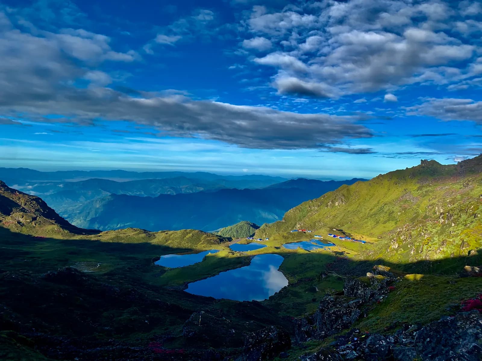
A five-day trek from Chhimti, near Melamchi, up through Tuppi Danda and Nesyampati to the five sacred lakes of Panch Pokhari at about 4,100 m in the Jugal Himal.
- Gün5
- En yüksek rakım4.100 m
- Mesafe33,2 km
- Yükseliş2.813 m
- ZorlukOrta–zor
- En iyi aylarMar–May, Oct–Nov
- İzinler3
Fotoğraf: RiCEKiLLER · CC BY-SA 4.0
İngilizce gösteriliyor — henüz çevrilmedi.
Bu rota bir taslaktır ve henüz doğrulanmadı. Etapları her zaman rehberinle teyit et.
Written by FindTrekkingPartner teamİnceleyen: FindTrekkingPartner teamNasıl inceliyoruzFindTrekkingPartner
Panch Pokhari Trek, Nepal’in Jugal Himal bölgesinde 4.100 m’ye çıkan 5 günlük bir trekkingdir. Yabancı trekkingciler FindTrekkingPartner’da tarihlerini, bütçelerini ve tempolarını belirterek bir gezi paylaşıp bu rota için partner bulabilir. Eşleşmeler iki trekkingci de kabul edene kadar gizli kalır ve hizmet ücretsizdir. Orta seviye fiyatlarla lisanslı bir rehber, dört trekkingci paylaştığında 5 günde kişi başı yaklaşık 47 USD tutar; tek başına giden bir trekkingci için bu tutar 187 USD’dir. En iyi sezonlar: Mar–May, Oct–Nov. Burada pratikte lisanslı rehber gereklidir: 2026 operatörlerine göre Nepal Turizm Kurulu’nun Nisan 2023 kuralı milli parklardaki ve koruma alanlarındaki kontrol noktalarında uygulanıyor; en sıkı denetim Langtang’da, Annapurna’da da kontrol yapılıyor (19 Ekim 2026’da kontrol edildi). Kayıtlı bir acente aracılığıyla rehber tut ve onlarla teyit et. Bu rota için açık geziler aşağıda; başlangıç ayı, grup büyüklüğü ve kalan yerlerle birlikte listelenir. Son doğrulama: 19 Ekim 2026. Kaynaklar: Nepal Turizm Kurulu, DNPWC, Göç İdaresi.
Kaynaklar:Department of Immigration, NepalNepal Tourism BoardDepartment of National Parks and Wildlife Conservation
Panch Pokhari Trek için partner bul
- Panch Pokhari Trek için partner bul3 açık gezi
Genel bakış
Başlangıç: Kathmandu5 gün · maks. 4.100 m
En iyi mevsimler: Mar–May, Oct–Nov · İzinler: No restricted-area permit, TIMS card where your agency requires it, Ask your agency about a park or local fee: the lakes lie near Langtang National Park
The Panch Pokhari trek is a five-day walk from the road at Chhimti, a few hours north of Melamchi, to a cluster of five alpine lakes at about 4,100 m below the Jugal Himal in Sindhupalchok District. It starts with a five to six hour drive from Kathmandu, then climbs about 6 km to the night stop at Tuppi Danda, continues to the hotel at Nesyampati at about 3,700 m, and reaches the lakes on the third day. The lakes are sacred to Hindus and Buddhists, and pilgrims come in August for Janai Purnima. The return follows the same trail, so the trek is out and back, with about 33 km of walking and 2,800 m of climbing in total. The trail is mostly a footpath and only partly marked, lodging is basic, and nights at 3,700 m and 4,100 m are cold.
The plan follows the short route described by Nepal Traveller, which gives the Chhimti start, the stop at Tuppi Danda and the timings, and it uses the Nesyampati and lake heights that two operators agree on. A longer route from Chautara, ten to sixteen days with camping, joins the same trail at Nesyampati. The lakes are not a restricted area, but ask your agency about any park or local fee, because the area lies next to Langtang National Park. The best months are March to May and October to November, when the weather is steady and the views of Dorje Lakpa are at their best.
Difficulty and fitness
The trek is moderate to hard for its length. You climb about 2,500 m in three days, sleep at about 3,700 m and 4,100 m, and the descent on day four is long. It suits fit walkers who have trekked before and know how they respond to altitude. Poles help on the descent, and a spare day after the trek covers road delays.
Budget notes
Nepal Traveller quotes NPR 7,000 to 10,000 per person for the short trek including transport, meals and lodging, which reflects independent travel on a budget. Our estimate on the costs section uses Nepal-wide lodge and meal ranges plus a guide, a porter and road transport, and shows the fare for the road as a line to check.
What to pack
A warm sleeping bag, down jacket, hat and gloves for nights at 3,700 m and 4,100 m, waterproofs, poles, water treatment and a head torch. Lodges are basic, so carry snacks.
Öne çıkanlar
- Panch Pokhari, five alpine lakes at about 4,100 m under Dorje Lakpa and Phurbi Chyachu
- A viewpoint about 45 minutes above the lakes at about 4,300 m
- Tamang hill villages and forest between Chhimti and Nesyampati
- A quiet trail close to Kathmandu, with no restricted-area permit
- Janai Purnima in August, when pilgrims bathe in the lakes
Rota haritası
Rota verileri OpenStreetMap'ten alındı, ekibimiz henüz kontrol etmedi. Planlama için kullan, navigasyon için değil.
Gün gün
A climb of about 5.7 km and 850 m takes four to five hours, by our estimate, from Tuppi Danda through forest and past Ratomato and Chokkardada, a ridge at about 3,100 m, to Nesyampati, where a hotel stands at about 3,700 m. The Nepal Traveller guide names a homestay and lodge here, and two operators agree on the height. The forest thins and the trail crosses rock and grass as you climb. It is a short day by distance, so there is time to rest, and a second night above 3,500 m is the best acclimatisation you can give yourself before the lakes.
A climb of about 4.9 km and 600 m, four to five hours, leads from Nesyampati through rock and tussock to Panch Pokhari, at about 4,100 m. Nepal Traveller says four hours and operators say five to six, and our estimate falls between. The five lakes lie in a shallow basin under the Jugal Himal, and a hotel stands beside them. In the afternoon you can walk about 45 minutes to a viewpoint at about 4,300 m, or rest. It is the highest night of the trek, and it will be cold, so bring a warm sleeping bag and hat.
Start early. A 30 to 60 minute walk to a viewpoint above the lakes at sunrise is optional, and then the long descent begins: about 10.6 km and 1,440 m down to Tuppi Danda, six to seven hours with the viewpoint, according to the operator itinerary. The trail is steep and rocky near the top and hard on the knees below, so use poles. You pass Nesyampati and Chokkardada on the way. Most of the descent is on loose path, and in rain or snow it is slippery. The lodge at Tuppi Danda is a welcome stop after the long day.
A walk of about 6 km, mostly downhill with 1,050 m of descent, takes you to Chhimti in about two hours, according to the Nepal Traveller guide. A vehicle meets you at the road and drives you back to Kathmandu through Melamchi in five to six hours, so you reach the city in the evening. Keep a margin for road conditions: landslides and road works between Melamchi and Chhimti can add hours, particularly after rain. If your flight home is the same night, leave a spare day after the trek.
İklimlendirme
Gece gece uyku rakımı. Kırmızı çubuklar bir önceki geceye göre 500 m'den fazla yükselir; dinlenme günleri işaretlidir.
- Uyku rakımı
- 500 m üzeri artış
- Dinlenme günü
Maliyeti
Kişi başı tahmini toplam maliyet: rakıma göre konaklama ve yemek, ulaşım, izinler, rehber ve porterler. Bir rehberi ve porterleri paylaşan trekkingci sayısı arttıkça kişi başı ödenen azalır. Ekim 2026 itibarıyla.
| Tarz | 1 trekkingci | 2 trekkingci paylaşıyor | 4 trekkingci paylaşıyor |
|---|---|---|---|
| Ekonomik | $110–$180* | $110–$180* | $110–$180* |
| Orta seviye | $360–$550* | $250–$390* | $210–$330* |
| Konforlu | $400–$610* | $330–$500* | $290–$440* |
Rehberi paylaş, tasarruf et
Orta seviyede, tek başına bir trekkingci yaklaşık $360–$550 öder; bir rehberi ve iki porteri paylaşan dört trekkingci kişi başı yaklaşık $210–$330 öder (aralığın üst ucunda %40 daha az).
Paylaşan 2 trekkingci için döküm
| Kalem | Ekonomik | Orta seviye | Konforlu |
|---|---|---|---|
| Konaklama ve yemek | $100–$160 | $130–$210 | $170–$270 |
| İzinler | $10–$20 | $10–$20 | $10–$20 |
| Rehber | — | $70–$120 | $70–$120 |
| Porterler | — | $30–$60 | $60–$110 |
Ekonomik tarz toplu taşıma kullanır ve porter içermez; orta seviye iki trekkingci arasında bir porter ve özel araç paylaşımı içerir; konforlu tarz her trekkingciye bir porter verir. Rehber, zorunlu olduğunda veya tarz orta seviye ya da konforlu olduğunda dahildir.
Gecelik konaklama ve yemek (oda ve bir dal bhat yemeği)
3 gece 2,500 to 3,800 m: oda $4–$11, dal bhat $5–$11 · 1 gece Above 3,800 m: oda $7–$19, dal bhat $8–$13
İzin ücretleri (resmi kaynaklar)
- TIMS card (trekking agency issued): NPR 2.000 giriş başına Kaynak
Dahil değil
Şunlar için yayımlanmış fiyat bulunamadı: Kathmandu to Chhimti by road (return). * ile işaretli toplamlar bunları içermez; acentenden sor. Lodges at Tuppi Danda, Nesyampati and the lakes are basic. Nepal Traveller quotes NPR 7,000 to 10,000 per person for the short trek including transport; the road fare is not in this estimate. Ask your agency whether a park or local fee applies.
Maliyet kaynakları
- PriceNepal: Nepal Travel Cost Guide 2026 (2026-05-14)
- Third Rock Adventures: Nepal trek budget planner (2026-05-09)
- Himalayan Partner: Guide and porter price in Nepal 2026 (2026-02-10)
- Shikhar Adventure: Annapurna Circuit trek cost (2026-02-03)
- Nepal Tourism Board: Trekking Permit (2026-10-18)
Teklif değil, operatör rehberlerinden tahminlerdir. Bahşişler, sigorta, ekipman ve Kathmandu otelleri dahil değildir; USD platform döviz kuruyladır.
Fotoğraflar
Sık sorulan sorular
This plan takes five days from Kathmandu to Kathmandu: one day of driving and walking up to Tuppi Danda, two climbing days to Nesyampati and the lakes, and two days down. Nepal Traveller describes a four-day version that goes from Tuppi Danda to the lakes in a single long day, and operators sell fifteen and sixteen day plans from Chautara.
About 4,100 m. Wikipedia, Nepal Traveller and two operators agree, and the elevation model gives about 4,060 m at the lake. A viewpoint above the lakes at about 4,300 m is a 30 to 45 minute walk.
The area is not on the Nepal Tourism Board's restricted-area list, so you do not need a Department of Immigration permit. Wikipedia places the lakes near Langtang National Park, and we found no official page that sets a fee for this trek, so ask your agency what it has arranged. A TIMS card may be requested.
March to May and October to November have the steadiest weather. Winter is possible with snow equipment, and in August the lakes are crowded with pilgrims at Janai Purnima, so book lodging early or avoid that week.
There are basic lodges at Tuppi Danda, a homestay and lodge at Nesyampati and a hotel at the lakes, according to Nepal Traveller. Operators note that some sections of the longer routes have no settlement, so those plans use tents.
Kaynaklar
Patika boyunca
Rotanın her gününde konaklama, sağlık desteği, su ve görülecek yerler.
1. Kathmandu → Tuppi Danda
Bu gün için henüz haritalanmış bir şey yok.Bu gün için henüz haritalanmış bir şey yok.2. Tuppi Danda → Nesyampati
Bu gün için henüz haritalanmış bir şey yok.Bu gün için henüz haritalanmış bir şey yok.3. Nesyampati → Panch Pokhari
- Nesyampati · Konaklama · 3.657 m
- Nasim Pati 3,700m · Manzara noktaları · 3.658 m
- Paanchpokhari · Doğa · 4.062 m
4. Panch Pokhari → Tuppi Danda
- Paanchpokhari · Doğa · 4.056 m
- Paanch Pokhari · Pratik · 4.050 m
5. Tuppi Danda → Kathmandu
Bu gün için henüz haritalanmış bir şey yok.Bu gün için henüz haritalanmış bir şey yok.
Son doğrulama: 19 Eki 2026Güncel olmayan bilgiyi bildir