

Start in the old town at Sitalpati, the white octagonal pavilion in the main square, and wander the steep Newari lanes past shops selling dhaka cloth and brass pots to the Palpa Durbar and its Mul Dhoka gateway. Then climb to Srinagar Hill, which Nepal Traveller gives as 30 to 60 minutes from the town centre. On our map the town and hill loop is 4.4 km with about 160 m of climbing. From the view tower, Wikipedia lists the peaks from Kanjiroba and Dhaulagiri to Annapurna, Manaslu, Ganesh and Langtang, so go at dawn or dusk. Return to town by the same lanes.
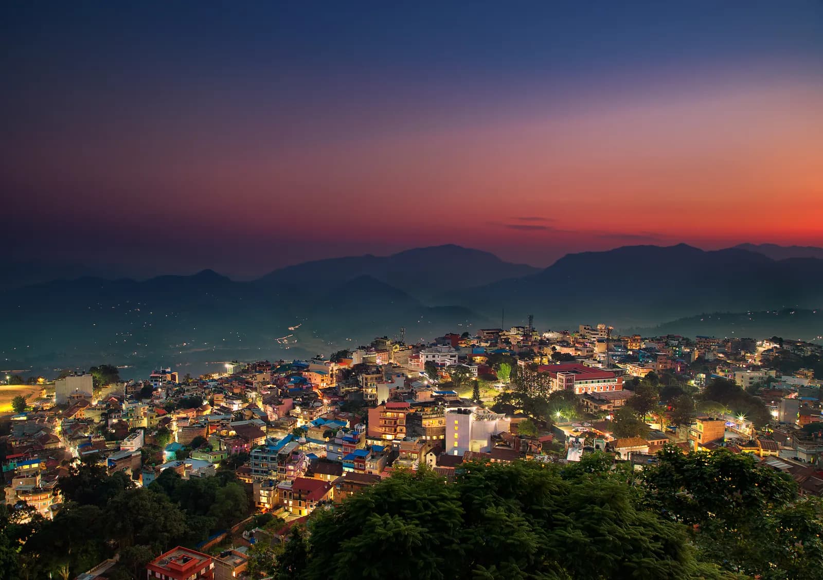
Tansen, Srinagar Hill and Ranighat
A two-day walk from the Magar hill town of Tansen: the lanes and the Srinagar Hill view tower on day one, and a 13 km descent to the Rani Mahal palace at Ranighat on day two, with no permit.
- จำนวนวัน2
- ความสูงสูงสุด1,490 ม.
- ระยะทาง17.4 กม.
- ระยะไต่ขึ้น298 ม.
- ระดับความยากง่าย
- เดือนที่ดีที่สุดOct–Nov, Mar–Apr
วางแผนทริปด้วยแผนการเดินทางนี้หาเพื่อนร่วมทางสำหรับ Tansen, Srinagar Hill and Ranighatดูรอบเดินทางรายสัปดาห์
ภาพ: Mithunkunwar9 · CC BY-SA 4.0
แสดงเป็นภาษาอังกฤษ — ยังไม่ได้แปล
แผนการเดินทางนี้เป็นฉบับร่างและยังไม่ได้ตรวจสอบ โปรดยืนยันแต่ละช่วงกับไกด์ของคุณเสมอ
Written by FindTrekkingPartner teamตรวจทานโดย FindTrekkingPartner teamวิธีที่เราตรวจทานFindTrekkingPartner
Tansen, Srinagar Hill and Ranighat เป็นเส้นทางเทรค 2 วันในภูมิภาค Palpa (Tansen) ของเนปาล ที่ขึ้นไปถึงความสูง 1,490 ม. นักเทรคชาวต่างชาติหาเพื่อนร่วมเทรคสำหรับเส้นทางนี้ได้ที่ FindTrekkingPartner โดยโพสต์ทริปพร้อมวันเดินทาง งบประมาณ และจังหวะการเดิน การจับคู่จะเป็นส่วนตัวจนกว่านักเทรคทั้งสองฝ่ายตกลง และบริการนี้ฟรี ที่ราคาระดับกลาง ไกด์ที่มีใบอนุญาตมีค่าใช้จ่ายประมาณ 19 USD ต่อคนตลอด 2 วัน เมื่อนักเทรคสี่คนหารกัน เทียบกับ 75 USD สำหรับนักเทรคที่ไปคนเดียว ช่วงฤดูที่ดีที่สุดคือ Oct–Nov, Mar–Apr ไม่มีการบังคับให้มีไกด์ที่มีใบอนุญาตบนเส้นทางเปิดเช่นนี้ (ตรวจสอบเมื่อ 19 ตุลาคม 2026) เทศบาลคุมบูไม่ใช้กฎเดือนเมษายน 2023 ของ Nepal Tourism Board และการเดินป่าแบบไปเช้าเย็นกลับไม่ต้องใช้ไกด์ แต่ยังคงแนะนำอย่างยิ่งให้มีไกด์ จึงควรยืนยันกับเอเจนซีของคุณ ทริปที่เปิดรับสำหรับเส้นทางนี้แสดงไว้ด้านล่าง พร้อมเดือนที่เริ่ม ขนาดกลุ่ม และจำนวนที่ว่างเหลือ ตรวจสอบล่าสุด: 19 ตุลาคม 2569 แหล่งข้อมูล: Nepal Tourism Board, DNPWC, กรมตรวจคนเข้าเมือง
แหล่งข้อมูล:Department of Immigration, NepalNepal Tourism BoardDepartment of National Parks and Wildlife Conservation
หาเพื่อนร่วมเทรคสำหรับ Tansen, Srinagar Hill and Ranighat
- หาเพื่อนร่วมเทรคสำหรับ Tansen, Srinagar Hill and Ranighatยังไม่มีทริปที่เปิดรับ
ภาพรวม
เริ่มจาก Tansen2 วัน · สูงสุด 1,490 ม.
ฤดูกาลที่ดีที่สุด: Oct–Nov, Mar–Apr
Tansen, Srinagar Hill and Ranighat is a two-day walking plan from the Magar hill town of Tansen in Palpa: a town and hill day to Sitalpati and the Srinagar view tower, and a long descent to Rani Mahal, the Rana palace at Ranighat on the Kali Gandaki. On our map the first day is 4.4 km with about 160 m of climbing and the second is 13.0 km with about 1,000 m of descent, mostly on the Rani Mahal road. Sources give 30 to 60 minutes from town to Srinagar Hill and 2 to 3 hours down to Ranighat, with a return climb of about 4 hours or a car, so the second day is a big one-way day. No permit or flight is needed, and October to November and March to April are best.
What the walk is like
Day one is gentle: the old lanes of Tansen, the white octagonal Sitalpati pavilion, the Palpa Durbar and the climb to Srinagar Hill for a view from Dhaulagiri to Langtang. Day two goes down the valley of the Barandi Khola, through terraces, forest and small farms, to Ranighat, where the restored Rani Mahal stands on a bluff above the river. Most walkers go down on foot and come back by car, since the climb back is steep and takes about 4 hours.
Day by day
Day one is 4.4 km, 2 to 3 hours including time in the town. Day two is 13.0 km down, 3 to 4 hours, and a car or the 4 hour climb back to Tansen. If you prefer a shorter day, drive to Batase Danda on the ridge and walk from there, as a 2008 trip report did, which gives about 3 hours down to Ranighat.
Getting there and away
Tansen lies between Pokhara (122 km) and Lumbini (85 km) on the highway between Butwal and Pokhara, with direct buses from Kathmandu, Pokhara and Bhairahawa; Bhairahawa is about two hours away.
Permits, guides and costs
No trekking permit or TIMS card is needed, and Palpa lies outside any national park, conservation area or restricted area, so no guide is required; one is optional. Costs are the two nights, the transfers and the car back from Ranighat; see the cost section for ranges.
Season and safety
Clear air in October to November makes the best views, and March to April is warm. The pebble trail and stone steps are slippery in fog and rain, and the valley is hot in spring. See our guide rule page for the rule in full.
จุดเด่น
- Old Tansen lanes with the octagonal Sitalpati pavilion and the Palpa Durbar
- Srinagar Hill view tower, 30 to 60 minutes from town, over Dhaulagiri, Annapurna and Langtang
- A long descent to Rani Mahal, the restored Rana palace on the Kali Gandaki
- Dhaka cloth and brass pots from the shops of the old town
- No permit and no flight
แผนที่เส้นทาง
ข้อมูลเส้นทางจาก OpenStreetMap ทีมงานของเรายังไม่ได้ตรวจสอบ ใช้เพื่อวางแผน ไม่ใช่เพื่อนำทาง
รายวัน
Leave early and head down towards the Kali Gandaki. Sources give 2 to 3 hours for the descent, and our map shows 13.0 km with about 1,000 m of descent, mostly by the Rani Mahal road through terraced fields and forest, so we allow 3 to 4 hours. Rani Mahal, built in 1893 by General Khadga Shamsher for his wife, stands on a wooded bluff above the river and has been a museum since its restoration in 2017. The climb back to Tansen takes about 4 hours and is steep, so most visitors arrange a car for the return, then rest in town.
ค่าใช้จ่าย
ค่าใช้จ่ายรวมโดยประมาณต่อคน: ที่พักและอาหารตามระดับความสูง การเดินทาง ใบอนุญาต รวมถึงไกด์และลูกหาบ ยิ่งมีนักเทรคแบ่งไกด์และลูกหาบมาก แต่ละคนยิ่งจ่ายน้อยลง ณ วันที่ ตุลาคม 2569
| สไตล์ | นักเทรค 1 คนแบ่งกัน | นักเทรค 2 คนแบ่งกัน | นักเทรค 4 คนแบ่งกัน |
|---|---|---|---|
| ประหยัด | US$30–US$60* | US$30–US$60* | US$30–US$60* |
| ระดับกลาง | US$130–US$220* | US$80–US$150* | US$70–US$120* |
| สบาย | US$150–US$240* | US$120–US$190* | US$100–US$170* |
แบ่งไกด์ ประหยัดเงิน
ที่ระดับกลาง นักเทรคเดี่ยวจ่ายประมาณ US$130–US$220 ส่วนนักเทรคสี่คนที่แบ่งไกด์หนึ่งคนและลูกหาบสองคนจ่ายประมาณคนละ US$70–US$120 (น้อยกว่า 44% ที่ช่วงบนสุด)
รายละเอียดสำหรับนักเทรค 2 คนที่แบ่งกัน
| รายการ | ประหยัด | ระดับกลาง | สบาย |
|---|---|---|---|
| ที่พักและอาหาร | US$30–US$60 | US$40–US$80 | US$50–US$100 |
| ไกด์ | — | US$20–US$50 | US$20–US$50 |
| ลูกหาบ | — | US$10–US$30 | US$30–US$60 |
แบบประหยัดใช้ขนส่งสาธารณะและไม่มีลูกหาบ แบบระดับกลางแบ่งลูกหาบหนึ่งคนระหว่างนักเทรคสองคนและใช้รถส่วนตัว แบบสบายให้นักเทรคแต่ละคนมีลูกหาบ รวมไกด์ในกรณีที่จำเป็นต้องมีหรือสไตล์เป็นระดับกลางหรือสบาย
ที่พักและอาหารต่อคืน (ห้องพักและดาลบาตหนึ่งมื้อ)
2 คืน Below 2,500 m: ห้อง US$2–US$9 ดาลบาต US$4–US$7
ไม่รวม
ไม่พบราคาที่เผยแพร่สำหรับ: Pokhara to Tansen by bus or car; Ranighat back to Tansen by car ยอดรวมที่มี * ไม่รวมรายการเหล่านี้ โปรดสอบถามเอเจนซี่ของคุณ A homestay-based walk with no permit: the costs are the nights, meals and the car back from Ranighat. A guide is optional.
แหล่งข้อมูลค่าใช้จ่าย
- PriceNepal: Nepal Travel Cost Guide 2026 (2026-05-14)
- Third Rock Adventures: Nepal trek budget planner (2026-05-09)
- Himalayan Partner: Guide and porter price in Nepal 2026 (2026-02-10)
- Shikhar Adventure: Annapurna Circuit trek cost (2026-02-03)
- Nepal Tourism Board: Trekking Permit (2026-10-18)
ค่าประมาณจากคู่มือของผู้ให้บริการ ไม่ใช่ใบเสนอราคา ไม่รวมทิป ประกัน อุปกรณ์ และโรงแรมในกาฐมาณฑุ USD ตามอัตราแลกเปลี่ยนของแพลตฟอร์ม
รูปภาพ
คำถามที่พบบ่อย
Sources give 2 to 3 hours down, and our map shows 13.0 km, so we allow 3 to 4 hours. The climb back is about 4 hours, or arrange a car.
Possible but long. Srinagar Hill is 30 to 60 minutes from town and the Ranighat descent 3 to 4 hours, so most walkers split the two days.
Yes. The palace was restored in 2017 and has a museum inside. Ask in Tansen about any ticket and the opening time on the day.
October to November for clear views and March to April for warm days; the monsoon brings cloud and mud.
No. Palpa is not a restricted area, and the walks avoid national parks and conservation areas. A guide is optional.
แหล่งข้อมูล
ตลอดเส้นทาง
ที่พัก ความช่วยเหลือทางการแพทย์ น้ำ และสถานที่น่าชมในแต่ละวันของเส้นทาง
1. Tansen
- Sangam medical hall · การแพทย์ · 1,281 ม.
- Ayush pharmacy · การแพทย์ · 1,273 ม.
- The Bajra · ที่พัก · 1,277 ม.
- Laxmi Homestay · ที่พัก · 1,331 ม.
- Horizon Homestay · ที่พัก · 1,350 ม.
- Annapurna garden · ที่พัก · 1,329 ม.
- View Tower · จุดชมวิว · 1,492 ม.
- Shreenagar View Tower · จุดชมวิว · 1,439 ม.
Show all 13 places
- The Bajra · ที่พัก · 1,277 ม.
- Lumbini Medical College · สนามบินและการเดินทาง · 873 ม.
- Hotel Tansen · ที่พัก · 1,262 ม.
- Sangam medical hall · การแพทย์ · 1,281 ม.
- Ayush pharmacy · การแพทย์ · 1,273 ม.
- Rock Regency Guest House · ที่พัก · 1,269 ม.
- Hotel Crown · ที่พัก · 1,305 ม.
- Laxmi Homestay · ที่พัก · 1,331 ม.
- Horizon Homestay · ที่พัก · 1,350 ม.
- Annapurna garden · ที่พัก · 1,329 ม.
- United Mission Tansen Hospital · การแพทย์ · 1,320 ม.
- View Tower · จุดชมวิว · 1,492 ม.
- Shreenagar View Tower · จุดชมวิว · 1,439 ม.
2. Tansen → Ranighat
- LMC Town Clinic · การแพทย์ · 1,277 ม.
- Indreni Restaurant and Lodge · ที่พัก · 1,275 ม.
- Ashoka Guest House $ · ที่พัก · 1,276 ม.
- Palpa District Hospital · การแพทย์ · 1,300 ม.
- The White Lake · ที่พัก · 1,312 ม.
- Batasedaada · จุดชมวิว · 1,393 ม.
- Rice fields Valley · จุดชมวิว · 1,010 ม.
- Dew Camping Resort · ที่พัก · 692 ม.
Show all 16 places
- Indreni Restaurant and Lodge · ที่พัก · 1,275 ม.
- Ashoka Guest House $ · ที่พัก · 1,276 ม.
- Upakar Medical Hall · การแพทย์ · 1,278 ม.
- LMC Town Clinic · การแพทย์ · 1,277 ม.
- The White Lake · ที่พัก · 1,312 ม.
- Palpa District Hospital · การแพทย์ · 1,300 ม.
- Hotel Gauri Shankar · ที่พัก · 1,294 ม.
- Bhattarai medical hall · การแพทย์ · 1,322 ม.
- City View Homestay · ที่พัก · 1,330 ม.
- Amatya Homestay · ที่พัก · 1,331 ม.
- Sunrise View Homestay · ที่พัก · 1,332 ม.
- Hotel Srinagar · ที่พัก · 1,420 ม.
- Batasedaada · จุดชมวิว · 1,393 ม.
- Rice fields Valley · จุดชมวิว · 1,010 ม.
- Ranimahal Fishing Resort · ที่พัก · 877 ม.
- Dew Camping Resort · ที่พัก · 692 ม.
ตรวจสอบล่าสุดเมื่อ 19 ต.ค. 2569แจ้งข้อมูลที่ล้าสมัย