

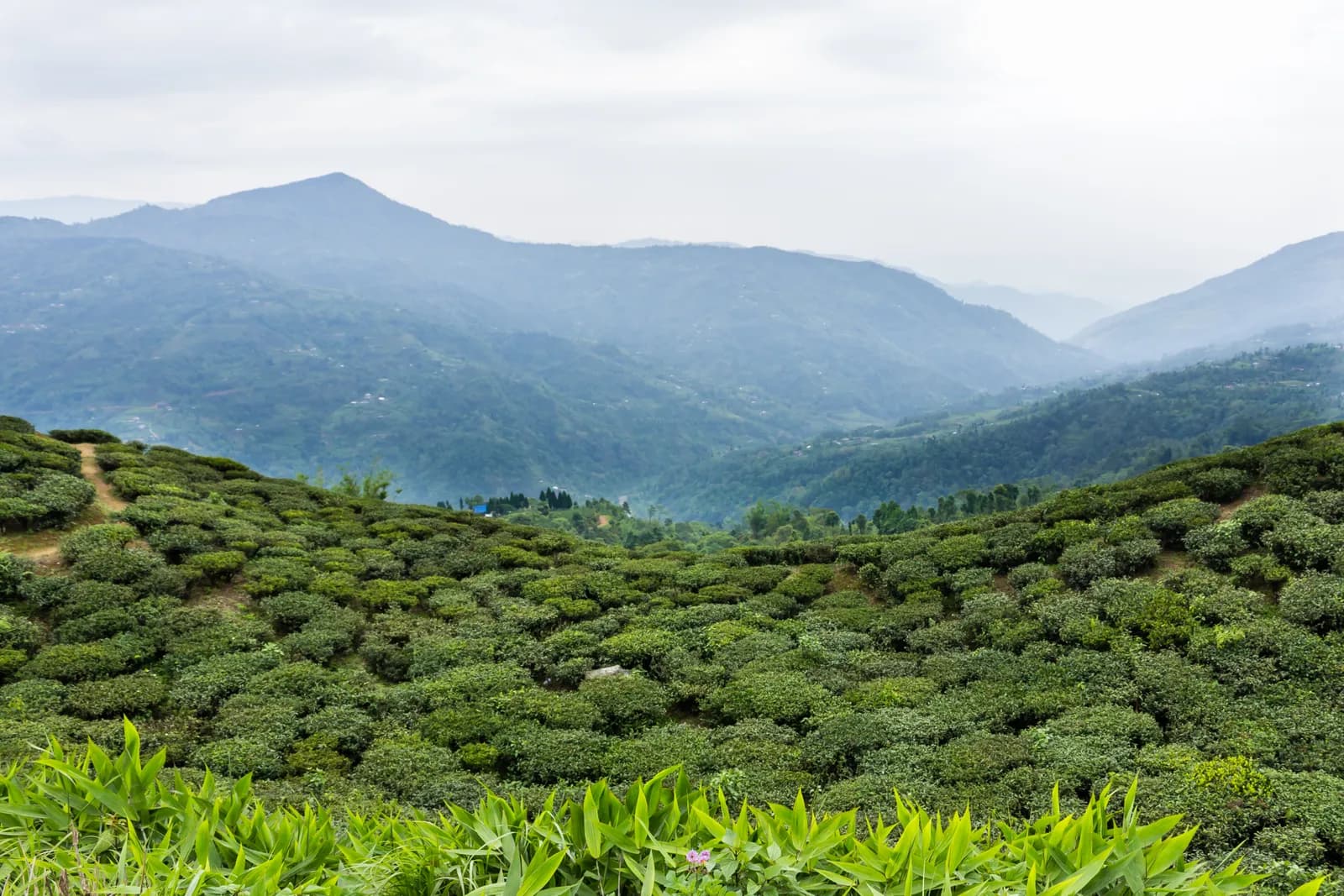
Reach Kanyam by taxi or bus and start early, when the air over the tea is clear. The mapped lanes run down through the estates to Fikkal, 5.3 km with about 150 m of descent and almost all on tea-estate and village roads, so allow 1.5 to 2 hours with stops. Kanyam sits at about 1,800 m by one source, with a 240 ha garden, and an operator suggests a factory visit before you leave. Fikkal is the commercial centre of the area, with a weekly haat on Thursdays, hotels and shops, and it is the base for the Antu Danda walk the next day.
Ilam Tea Gardens and Antu Danda
A three-day walk in Ilam's tea country: down through the Kanyam estates to Fikkal, then 16.7 km to the Antu Danda watchtower for a sunrise over Kanchenjunga, Makalu and Everest, with no permit.
- จำนวนวัน3
- ความสูงสูงสุด2,328 ม.
- ระยะทาง38.8 กม.
- ระยะไต่ขึ้น1,315 ม.
- ระดับความยากง่าย
- เดือนที่ดีที่สุดMar–Jun, Sep–Nov
วางแผนทริปด้วยแผนการเดินทางนี้หาเพื่อนร่วมทางสำหรับ Ilam Tea Gardens and Antu Dandaดูรอบเดินทางรายสัปดาห์
ภาพ: Bijay chaurasia · CC BY-SA 4.0
แสดงเป็นภาษาอังกฤษ — ยังไม่ได้แปล
แผนการเดินทางนี้เป็นฉบับร่างและยังไม่ได้ตรวจสอบ โปรดยืนยันแต่ละช่วงกับไกด์ของคุณเสมอ
Written by FindTrekkingPartner teamตรวจทานโดย FindTrekkingPartner teamวิธีที่เราตรวจทานFindTrekkingPartner
Ilam Tea Gardens and Antu Danda เป็นเส้นทางเทรค 3 วันในภูมิภาค Ilam ของเนปาล ที่ขึ้นไปถึงความสูง 2,328 ม. นักเทรคชาวต่างชาติหาเพื่อนร่วมเทรคสำหรับเส้นทางนี้ได้ที่ FindTrekkingPartner โดยโพสต์ทริปพร้อมวันเดินทาง งบประมาณ และจังหวะการเดิน การจับคู่จะเป็นส่วนตัวจนกว่านักเทรคทั้งสองฝ่ายตกลง และบริการนี้ฟรี ที่ราคาระดับกลาง ไกด์ที่มีใบอนุญาตมีค่าใช้จ่ายประมาณ 28 USD ต่อคนตลอด 3 วัน เมื่อนักเทรคสี่คนหารกัน เทียบกับ 112 USD สำหรับนักเทรคที่ไปคนเดียว ช่วงฤดูที่ดีที่สุดคือ Mar–Jun, Sep–Nov ไม่มีการบังคับให้มีไกด์ที่มีใบอนุญาตบนเส้นทางเปิดเช่นนี้ (ตรวจสอบเมื่อ 19 ตุลาคม 2026) เทศบาลคุมบูไม่ใช้กฎเดือนเมษายน 2023 ของ Nepal Tourism Board และการเดินป่าแบบไปเช้าเย็นกลับไม่ต้องใช้ไกด์ แต่ยังคงแนะนำอย่างยิ่งให้มีไกด์ จึงควรยืนยันกับเอเจนซีของคุณ ทริปที่เปิดรับสำหรับเส้นทางนี้แสดงไว้ด้านล่าง พร้อมเดือนที่เริ่ม ขนาดกลุ่ม และจำนวนที่ว่างเหลือ ตรวจสอบล่าสุด: 19 ตุลาคม 2569 แหล่งข้อมูล: Nepal Tourism Board, DNPWC, กรมตรวจคนเข้าเมือง
แหล่งข้อมูล:Department of Immigration, NepalNepal Tourism BoardDepartment of National Parks and Wildlife Conservation
หาเพื่อนร่วมเทรคสำหรับ Ilam Tea Gardens and Antu Danda
- หาเพื่อนร่วมเทรคสำหรับ Ilam Tea Gardens and Antu Danda1 ทริปที่เปิดรับ
ภาพรวม
เริ่มจาก Kanyam3 วัน · สูงสุด 2,328 ม.
ฤดูกาลที่ดีที่สุด: Mar–Jun, Sep–Nov
The Ilam Tea Gardens and Antu Danda trek is a three-day walk through the tea country of eastern Nepal: a morning down through the Kanyam estates to Fikkal, then the road walk from Fikkal to the Antu Danda watchtower (about 2,000 m), a night near the viewpoint, and the return at sunrise. On our map the three days are 5.3 km, 16.7 km and 16.7 km, with about 610 m of climbing on the two long days, and almost all of it on village roads and tea-estate lanes. An operator gives 11 km and 3 to 4 hours up and 5 to 6 hours back, so we allow 4 to 6 hours each way. No permit, no flight inside the route and no altitude are involved, and the best months are March to June and September to November.
What the walk is like
Day one is a gentle descent from Kanyam, the best-known tea garden in the district, to the bazaar town of Fikkal. Day two follows village roads east to Shree Antu, past tea, cardamom and forest, and ends at Antu Danda, where you sleep close to the watchtower. Day three starts before dawn for the view of Kanchenjunga, Makalu and Everest, then returns to Fikkal by the same road or by a vehicle from Shree Antu. The walking is easy but long, mostly on roads, so it suits people who like to take the days slowly.
Day by day
Day one is 5.3 km down from Kanyam to Fikkal, 1.5 to 2 hours, mostly on tea-estate roads. Day two is the long walk to Antu Danda, 16.7 km on our map and 4 to 6 hours with stops, sleeping close to the watchtower. Day three is the sunrise and the return to Fikkal, another 16.7 km, with the option of a vehicle from Shree Antu. Mai Pokhari is not on the walking route, since it lies in a different part of the district, but it makes an easy extra morning if you have a vehicle.
Getting there and away
Most visitors fly to Bhadrapur or Chandragadhi in Jhapa and drive north to Fikkal, which is about 700 km from Kathmandu by road. Kanyam is a short ride from Fikkal. A vehicle can pick you up from Shree Antu on day two or three.
Permits, guides and costs
No trekking permit or TIMS card is needed, and Ilam lies outside any national park, conservation area or restricted area, so no guide is required; one is optional. Costs are two nights of lodging, the transfers and any guide; see the cost section for ranges.
Season and safety
Spring and autumn are best, and autumn is clearest for the Himalayan view. The roads are muddy in the monsoon and mist can hide the sunrise, so build in a spare morning. See our guide rule page for the rule in full.
จุดเด่น
- Kanyam, the best-known tea garden of Ilam, with long views over the estates
- Fikkal bazaar and its Thursday haat
- Sunrise from the Antu Danda watchtower over Kanchenjunga, Makalu and Everest
- Easy walking on village roads with no permit and no altitude
- Mai Pokhari, a Ramsar-listed lake, as a drive from Ilam Bazaar
แผนที่เส้นทาง
ข้อมูลเส้นทางจาก OpenStreetMap ทีมงานของเรายังไม่ได้ตรวจสอบ ใช้เพื่อวางแผน ไม่ใช่เพื่อนำทาง
รายวัน
Walk east from Fikkal on village roads through tea gardens, cardamom fields and patches of forest to Shree Antu and the Antu Danda hill. One operator gives 11 km and 3 to 4 hours for this walk; the road we mapped is 16.7 km with about 610 m of climbing and a similar amount of descent, so we allow 4 to 6 hours with stops for tea. Mist and heat can both build by afternoon, so start early and carry water. A homestay near the viewpoint puts you a short walk from the watchtower for tomorrow's sunrise, with the hills of Darjeeling on the horizon on a clear evening.
Climb the watchtower before dawn: an operator lists Kanchenjunga (8,586 m), Makalu (8,463 m) and Everest (8,848 m) from here on a clear morning. After breakfast, walk back to Fikkal on the same roads, 16.7 km on our map, which the same operator gives as 5 to 6 hours. If your legs are tired, a vehicle can meet you at Shree Antu, and a drive of about 1 hour to Pashupatinagar or about 3 hours to Ilam Bazaar takes you on towards Mai Pokhari or the airport.
ค่าใช้จ่าย
ค่าใช้จ่ายรวมโดยประมาณต่อคน: ที่พักและอาหารตามระดับความสูง การเดินทาง ใบอนุญาต รวมถึงไกด์และลูกหาบ ยิ่งมีนักเทรคแบ่งไกด์และลูกหาบมาก แต่ละคนยิ่งจ่ายน้อยลง ณ วันที่ ตุลาคม 2569
| สไตล์ | นักเทรค 1 คนแบ่งกัน | นักเทรค 2 คนแบ่งกัน | นักเทรค 4 คนแบ่งกัน |
|---|---|---|---|
| ประหยัด | US$30–US$60* | US$30–US$60* | US$30–US$60* |
| ระดับกลาง | US$170–US$290* | US$110–US$180* | US$80–US$150* |
| สบาย | US$190–US$310* | US$150–US$240* | US$120–US$210* |
แบ่งไกด์ ประหยัดเงิน
ที่ระดับกลาง นักเทรคเดี่ยวจ่ายประมาณ US$170–US$290 ส่วนนักเทรคสี่คนที่แบ่งไกด์หนึ่งคนและลูกหาบสองคนจ่ายประมาณคนละ US$80–US$150 (น้อยกว่า 49% ที่ช่วงบนสุด)
รายละเอียดสำหรับนักเทรค 2 คนที่แบ่งกัน
| รายการ | ประหยัด | ระดับกลาง | สบาย |
|---|---|---|---|
| ที่พักและอาหาร | US$30–US$60 | US$40–US$80 | US$50–US$100 |
| ไกด์ | — | US$40–US$70 | US$40–US$70 |
| ลูกหาบ | — | US$20–US$40 | US$40–US$80 |
แบบประหยัดใช้ขนส่งสาธารณะและไม่มีลูกหาบ แบบระดับกลางแบ่งลูกหาบหนึ่งคนระหว่างนักเทรคสองคนและใช้รถส่วนตัว แบบสบายให้นักเทรคแต่ละคนมีลูกหาบ รวมไกด์ในกรณีที่จำเป็นต้องมีหรือสไตล์เป็นระดับกลางหรือสบาย
ที่พักและอาหารต่อคืน (ห้องพักและดาลบาตหนึ่งมื้อ)
2 คืน Below 2,500 m: ห้อง US$2–US$9 ดาลบาต US$4–US$7
ไม่รวม
ไม่พบราคาที่เผยแพร่สำหรับ: Fikkal to Kanyam by taxi or bus; Antu Danda back to Fikkal by vehicle (optional) ยอดรวมที่มี * ไม่รวมรายการเหล่านี้ โปรดสอบถามเอเจนซี่ของคุณ A lodge-based walk with no permit: the costs are two nights, meals and transfers. A guide is optional.
แหล่งข้อมูลค่าใช้จ่าย
- PriceNepal: Nepal Travel Cost Guide 2026 (2026-05-14)
- Third Rock Adventures: Nepal trek budget planner (2026-05-09)
- Himalayan Partner: Guide and porter price in Nepal 2026 (2026-02-10)
- Shikhar Adventure: Annapurna Circuit trek cost (2026-02-03)
- Nepal Tourism Board: Trekking Permit (2026-10-18)
ค่าประมาณจากคู่มือของผู้ให้บริการ ไม่ใช่ใบเสนอราคา ไม่รวมทิป ประกัน อุปกรณ์ และโรงแรมในกาฐมาณฑุ USD ตามอัตราแลกเปลี่ยนของแพลตฟอร์ม
รูปภาพ
คำถามที่พบบ่อย
An operator gives 11 km and 3 to 4 hours up, and 5 to 6 hours back. Our map follows village roads for 16.7 km, so we allow 4 to 6 hours each way.
Yes, by vehicle: sources give about 3 hours from Ilam Bazaar and about 1 hour from Pashupatinagar. Sleeping near the viewpoint is better for the sunrise.
An operator lists Kanchenjunga, Makalu and Everest at sunrise, and the hills of Darjeeling on a clear day.
Yes. It is the best known tea garden in Ilam, with a 240 ha estate and a factory that operators include in tours, and it is a short ride from Fikkal.
March to June and September to November. Autumn has the clearest air, and the monsoon brings cloud and mud.
แหล่งข้อมูล
ตลอดเส้นทาง
ที่พัก ความช่วยเหลือทางการแพทย์ น้ำ และสถานที่น่าชมในแต่ละวันของเส้นทาง
1. Kanyam → Fikkal
- Viewpoint · จุดชมวิว · 1,644 ม.
- Kanyum cottage village · ที่พัก · 1,604 ม.
- Phikkal Hospital · การแพทย์ · 1,562 ม.
- Hotel Shikher · ที่พัก · 1,579 ม.
- Hotel Bishal · ที่พัก · 1,561 ม.
- Hotel Sonam · ที่พัก · 1,556 ม.
Show all 10 places
- Viewpoint · จุดชมวิว · 1,644 ม.
- Kanyum cottage village · ที่พัก · 1,604 ม.
- Kharel hotel and Lodge · ที่พัก · 1,548 ม.
- Rinchhen Hotel and Lodge · ที่พัก · 1,546 ม.
- Rinchen Hotel & lodge · ที่พัก · 1,541 ม.
- Sun Hotel and Lodge · ที่พัก · 1,544 ม.
- Phikkal Hospital · การแพทย์ · 1,562 ม.
- Hotel Shikher · ที่พัก · 1,579 ม.
- Hotel Bishal · ที่พัก · 1,561 ม.
- Hotel Sonam · ที่พัก · 1,556 ม.
2. Fikkal → Antu Danda
- Hotel Snow View · ที่พัก · 1,641 ม.
- Shri Antu Pharmacy · การแพทย์ · 1,644 ม.
- ABC Homestay · ที่พัก · 1,643 ม.
- Kaijen Hotel · ที่พัก · 1,642 ม.
- Kausal Homestay · ที่พัก · 1,694 ม.
Show all 6 places
- Hotel Snow View · ที่พัก · 1,641 ม.
- Shri Antu Pharmacy · การแพทย์ · 1,644 ม.
- ABC Homestay · ที่พัก · 1,643 ม.
- Kaijen Hotel · ที่พัก · 1,642 ม.
- Kausal Homestay · ที่พัก · 1,694 ม.
- Khadka Homestay · ที่พัก · 1,703 ม.
3. Antu Danda → Fikkal
- Antu Hill · จุดชมวิว · 1,824 ม.
- Antu Lake · ธรรมชาติ · 1,658 ม.
- Hotel Elite · ที่พัก · 1,575 ม.
- Lodge · ที่พัก · 1,560 ม.
- Hotel Dawa · ที่พัก · 1,559 ม.
- Pathivara poly clinic · การแพทย์ · 1,576 ม.
- Hotel Mandala · ที่พัก · 1,564 ม.
Show all 11 places
- Antu Hill · จุดชมวิว · 1,824 ม.
- Pradhan Homestay · ที่พัก · 1,684 ม.
- Misara Homestay · ที่พัก · 1,694 ม.
- Ghimire Homestay · ที่พัก · 1,643 ม.
- Antu Lake · ธรรมชาติ · 1,658 ม.
- Antu Homestay · ที่พัก · 1,662 ม.
- Hotel Elite · ที่พัก · 1,575 ม.
- Lodge · ที่พัก · 1,560 ม.
- Hotel Dawa · ที่พัก · 1,559 ม.
- Pathivara poly clinic · การแพทย์ · 1,576 ม.
- Hotel Mandala · ที่พัก · 1,564 ม.
ตรวจสอบล่าสุดเมื่อ 19 ต.ค. 2569แจ้งข้อมูลที่ล้าสมัย