

Leave Kathmandu early for the drive north to Syabrubesi, at about 1,500 m, on the Trisuli road past Trisuli Bazaar and the approach to Langtang. Operators give 6 to 9 hours depending on the vehicle and the state of the road; the bus is slower and cheaper than a jeep. The road is narrow and winding, with some landslide sections. Syabrubesi is the busy start of the Langtang and Tamang Heritage routes, so you will see other trekkers. Check in to a lodge, confirm your permit paperwork with the guide, pack a daypack and have an early night before the first walking day.
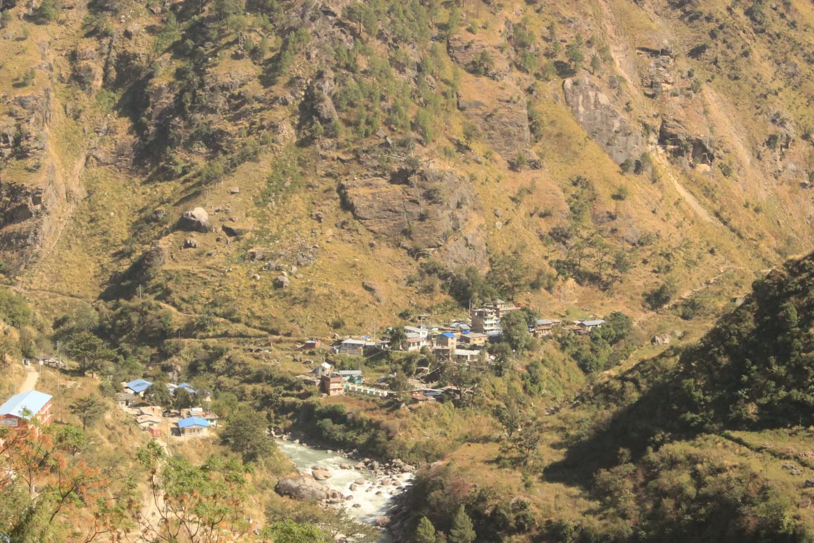
Ruby Valley and Ganesh Himal Trek
A 7-day village trek from Syabrubesi over Pangsang Pass to Tipling and Chalish, with a rest day around Chalish and a drive back through Dhading Besi.
- จำนวนวัน7
- ความสูงสูงสุด3,850 ม.
- ระยะทาง43.7 กม.
- ระยะไต่ขึ้น3,638 ม.
- ระดับความยากปานกลาง
- เดือนที่ดีที่สุดMar–May, Oct–Nov
- ใบอนุญาต2
วางแผนทริปด้วยแผนการเดินทางนี้หาเพื่อนร่วมทางสำหรับ Ruby Valley and Ganesh Himal Trekดูรอบเดินทางรายสัปดาห์
ภาพ: Rajivkilanashrestha · CC BY-SA 4.0
คำเตือนRuby Valley: the Syabrubesi start is not currently reliable
This route drives to Syabrubesi on day 1 and finishes at Chalish with a drive back through Dhading Besi. On 26 August 2026 a large rock-and-ice collapse from the north face of Langtang Lirung sent a debris flow down the Lhende Khola into the Bhote Koshi and Trishuli rivers, hitting Rasuwagadhi, Timure, Syabrubesi and Betrawati (ICIMOD). Many bridges and long stretches of the Pasang Lhamu Highway were damaged, and a large number of people died or are missing; reported figures differ by source.
Syabrubesi, the usual Langtang road-head, is reported destroyed or closed as a trekking gateway, with the bridge to it swept away; restoration depends on the Betrawati highway reopening. The Trishuli Bazaar-Betrawati-Dhunche road was reported still closed for repair as of 21 September. A light-vehicle track has reopened, and agencies projected the remaining gaps passable no earlier than mid-October; that is a projection, not an official date.
We found no source on the condition of the Ruby Valley trail itself or a reopening date. We found no official reopening notice. Check current road and trail conditions with Langtang National Park and your trekking agency before booking, and do not rely on this summary alone.
ตรวจสอบสถานะเมื่อ 2026-10-19
แหล่งข้อมูล: ICIMOD: Kyirong-Rasuwa flood, 26 August 2026 · Nepal Pyramids: Langtang Valley trek update after the 2026 flooding · Republica: locals reopen flood-damaged Langtang trekking route (16 Oct)
แสดงเป็นภาษาอังกฤษ — ยังไม่ได้แปล
แผนการเดินทางนี้เป็นฉบับร่างและยังไม่ได้ตรวจสอบ โปรดยืนยันแต่ละช่วงกับไกด์ของคุณเสมอ
Written by FindTrekkingPartner teamตรวจทานโดย FindTrekkingPartner teamวิธีที่เราตรวจทานFindTrekkingPartner
Ruby Valley and Ganesh Himal Trek เป็นเส้นทางเทรค 7 วันในภูมิภาค Ganesh Himal ของเนปาล ที่ขึ้นไปถึงความสูง 3,850 ม. นักเทรคชาวต่างชาติหาเพื่อนร่วมเทรคสำหรับเส้นทางนี้ได้ที่ FindTrekkingPartner โดยโพสต์ทริปพร้อมวันเดินทาง งบประมาณ และจังหวะการเดิน การจับคู่จะเป็นส่วนตัวจนกว่านักเทรคทั้งสองฝ่ายตกลง และบริการนี้ฟรี ที่ราคาระดับกลาง ไกด์ที่มีใบอนุญาตมีค่าใช้จ่ายประมาณ 65 USD ต่อคนตลอด 7 วัน เมื่อนักเทรคสี่คนหารกัน เทียบกับ 261 USD สำหรับนักเทรคที่ไปคนเดียว ช่วงฤดูที่ดีที่สุดคือ Mar–May, Oct–Nov ในทางปฏิบัติต้องมีไกด์ที่มีใบอนุญาตที่นี่ ผู้ประกอบการในปี 2026 รายงานว่ากฎเดือนเมษายน 2023 ของ Nepal Tourism Board บังคับใช้ที่จุดตรวจในอุทยานแห่งชาติและพื้นที่อนุรักษ์ โดยแลงตังเข้มงวดที่สุดและอันนาปุรณะก็ตรวจเช่นกัน (ตรวจสอบเมื่อ 19 ตุลาคม 2026) ควรจ้างไกด์ผ่านเอเจนซีที่จดทะเบียนและยืนยันกับเอเจนซี ทริปที่เปิดรับสำหรับเส้นทางนี้แสดงไว้ด้านล่าง พร้อมเดือนที่เริ่ม ขนาดกลุ่ม และจำนวนที่ว่างเหลือ ตรวจสอบล่าสุด: 19 ตุลาคม 2569 แหล่งข้อมูล: Nepal Tourism Board, DNPWC, กรมตรวจคนเข้าเมือง
แหล่งข้อมูล:Department of Immigration, NepalNepal Tourism BoardDepartment of National Parks and Wildlife Conservation
หาเพื่อนร่วมเทรคสำหรับ Ruby Valley and Ganesh Himal Trek
- หาเพื่อนร่วมเทรคสำหรับ Ruby Valley and Ganesh Himal Trekยังไม่มีทริปที่เปิดรับ
ภาพรวม
เริ่มจาก Kathmanduช่องเขา: Pangsang Pass7 วัน · สูงสุด 3,850 ม.
ฤดูกาลที่ดีที่สุด: Mar–May, Oct–Nov · ใบอนุญาต: Langtang National Park entry permit, TIMS card where required
The Ruby Valley trek is a seven-day walk through the villages and forests on the south-west side of Ganesh Himal. It drives from Kathmandu to Syabrubesi, the Langtang trailhead, walks over Bahun Danda to the Tamang village of Gatlang, climbs to the forest camp at Somdang (about 3,270 m), crosses Pangsang Pass at about 3,850 m and descends to Tipling, then walks through the Tamang village of Sertung to Chalish, with a rest day around Chalish for Sertung and the Tatopani hot spring before a drive back to Kathmandu via Dhading Besi. The walking adds up to about 44 km on our mapped route with roughly 3,600 m of climbing, following the stages of the Nepal Alternative Treks, Himalaya Trip and Peregrine itineraries in the sources. It is a moderate trek, needs the Langtang National Park permit and no restricted-area permit, and runs best from late September to early December and in spring.
What the trek is like
The first day on foot climbs from the Bhote Koshi valley through forest to Bahun Danda and on to Gatlang, a village of dark stone houses at about 2,300 m. The next two days go up into pine and rhododendron forest to Somdang and over Pangsang Pass, where on clear days Ganesh Himal fills the northern horizon. The final descent leads through millet and maize terraces to Tipling and Chalish, villages where local families run homestays.
Permits and rules
The Langtang National Park entry permit is NPR 3,000 for foreigners (Nepal Tourism Board). A TIMS card is listed by some operators. The trek is not in a restricted area, so there is no minimum group size, but trails above Somdang are quiet, so most people go with a guide.
Best season
Mid-September to mid-December and March to May. Monsoon trails are slippery and leech-prone.
Altitude
The highest overnight is Somdang at about 3,270 m and the pass is about 3,850 m, so most people feel the height only as a little breathlessness. Walk slowly and drink well.
Getting there and away
Kathmandu to Syabrubesi is 6 to 9 hours by road, and Chalish to Kathmandu about 8 hours via Dhading Besi. Plan one spare day if road works or landslides are reported.
Lodges, food and costs
Homestays and simple guesthouses serve dal bhat. See the permit fees and sample costs in the costs section.
Extensions
Operators extend the trek with an acclimatisation day at Somdang, a walk on to Jharlang and Darkha, or a longer circuit through Hindung to Ganesh Himal Base Camp, which has no lodges.
จุดเด่น
- Gatlang, a Tamang village of stone houses and pilgrim lake
- Somdang, a forest camp at about 3,270 m below Ganesh Himal
- Pangsang Pass at about 3,850 m, with views of the Ganesh Himal range
- Tipling and Chalish, farming villages with homestays and the Tatopani hot spring nearby
- A moderate trek with no restricted-area permit
แผนที่เส้นทาง
ข้อมูลเส้นทางจาก OpenStreetMap ทีมงานของเรายังไม่ได้ตรวจสอบ ใช้เพื่อวางแผน ไม่ใช่เพื่อนำทาง
รายวัน
คุณนอนสูงกว่าคืนก่อน 834 ม. เกินแนวทางปกติที่ 500 ม. ค่อยๆ ไป ดื่มน้ำมากๆ และสังเกตอาการปวดศีรษะหรือคลื่นไส้
Cross to the west bank of the Bhote Koshi and climb through forest and farmland over Bahun Danda to Gatlang, at about 2,300 m. Operators allow 4 to 6 hours for the 11 km, and the gain is about 1,060 m. Gatlang is a Tamang village of stone houses, wooden balconies and prayer flags, with a pilgrim lake nearby. Walk through the lanes in the afternoon, and be respectful when entering temples or taking photos of people. Homestay families cook dal bhat and local food. The altitude is modest, but drink a lot and climb slowly.
คุณนอนสูงกว่าคืนก่อน 934 ม. เกินแนวทางปกติที่ 500 ม. ค่อยๆ ไป ดื่มน้ำมากๆ และสังเกตอาการปวดศีรษะหรือคลื่นไส้
A long day of 6 to 7 hours takes you from Gatlang to Somdang, at about 3,270 m, climbing about 1,500 m over 12.6 km. The trail goes through dense pine and rhododendron forest, passing Khurpu Bhanjyang, a saddle of about 3,700 m on the map, before the final stretch to Somdang. The hamlet has a few guesthouses on a clearing with views down the valley. It is the highest night of the trek, so go slowly, eat well and wrap up in the evening, when the air turns cold quickly.
The hardest day: leave early and climb above the tree line to Pangsang Pass, at about 3,850 m, where the views take in the Ganesh Himal range on a clear morning. Then descend steeply through forest to Tipling, at about 2,000 m, a drop of about 1,800 m from the pass over 15 km on our mapped route. Operators allow 7 to 8 hours in total, and some call it 8 to 10, so start at first light and carry lunch. Poles are a great help on the knee-jarring descent. Tipling's homestays give a welcome rest at the end.
Walk down from Tipling through millet and maize terraces to Sertung, a Tamang village, and on to Chalish Gaon at about 1,675 m. Operators give 3 to 5 hours for the day, depending on how long you spend among the Sertung houses. Our map follows the footpath through Sertung: 4.7 km with about 360 m of climbing and 690 m of descent, so the day is short on distance but has a lot of up and down. One operator counts 12 km for the same day because it also visits upper villages that OpenStreetMap does not map. Stop in Sertung for tea, then continue to Chalish, home to Gurung, Ghale and Kami families, where the lower altitude and warmer evenings make a pleasant place to rest.
A rest day around Chalish with an optional walk of about 4 to 5 hours: operators suggest a round trip to Sertung, a viewpoint, and the Tatopani hot spring, where you can soak tired legs. The route is gentle and mostly on village paths, and you can shorten it or skip it. Ask your host about a cultural evening if you want music and dance, usually arranged on request. This is also the sensible day to wash clothes, back up photos and repack for the road, because the last day is a long drive.
Drive from Chalish via Dhading Besi to Kathmandu, a journey of about 8 hours on the Dhading and Prithvi roads. Operators quote between 7 and 9 hours with a mix of private jeep and bus; the stretch to Dhading Besi is rough and slow, and the rest is on tarmac. Leave early, take snacks and water, and keep a spare day in your plans if the monsoon or road works are reported. Back in Kathmandu, hand back any rented gear and settle up with the guide and drivers.
การปรับตัวกับความสูง
ระดับความสูงที่นอนในแต่ละคืน แท่งสีแดงคือสูงขึ้นเกิน 500 ม. จากคืนก่อน วันพักมีเครื่องหมายกำกับ
- ความสูงที่นอน
- สูงขึ้นเกิน 500 ม.
- วันพัก
ค่าใช้จ่าย
ค่าใช้จ่ายรวมโดยประมาณต่อคน: ที่พักและอาหารตามระดับความสูง การเดินทาง ใบอนุญาต รวมถึงไกด์และลูกหาบ ยิ่งมีนักเทรคแบ่งไกด์และลูกหาบมาก แต่ละคนยิ่งจ่ายน้อยลง ณ วันที่ ตุลาคม 2569
| สไตล์ | นักเทรค 1 คนแบ่งกัน | นักเทรค 2 คนแบ่งกัน | นักเทรค 4 คนแบ่งกัน |
|---|---|---|---|
| ประหยัด | US$340–US$430 | US$240–US$330 | US$190–US$280 |
| ระดับกลาง | US$770–US$1,150 | US$470–US$700 | US$340–US$510 |
| สบาย | US$820–US$1,200 | US$560–US$830 | US$430–US$650 |
แบ่งไกด์ ประหยัดเงิน
ที่ระดับกลาง นักเทรคเดี่ยวจ่ายประมาณ US$770–US$1,150 ส่วนนักเทรคสี่คนที่แบ่งไกด์หนึ่งคนและลูกหาบสองคนจ่ายประมาณคนละ US$340–US$510 (น้อยกว่า 55% ที่ช่วงบนสุด)
รายละเอียดสำหรับนักเทรค 2 คนที่แบ่งกัน
| รายการ | ประหยัด | ระดับกลาง | สบาย |
|---|---|---|---|
| ที่พักและอาหาร | US$100–US$170 | US$130–US$230 | US$190–US$300 |
| การเดินทาง | US$100–US$130 | US$150–US$220 | US$150–US$220 |
| ใบอนุญาต | US$30–US$40 | US$30–US$40 | US$30–US$40 |
| ไกด์ | — | US$100–US$160 | US$100–US$160 |
| ลูกหาบ | — | US$30–US$70 | US$70–US$130 |
แบบประหยัดใช้ขนส่งสาธารณะและไม่มีลูกหาบ แบบระดับกลางแบ่งลูกหาบหนึ่งคนระหว่างนักเทรคสองคนและใช้รถส่วนตัว แบบสบายให้นักเทรคแต่ละคนมีลูกหาบ รวมไกด์ในกรณีที่จำเป็นต้องมีหรือสไตล์เป็นระดับกลางหรือสบาย
ที่พักและอาหารต่อคืน (ห้องพักและดาลบาตหนึ่งมื้อ)
5 คืน Below 2,500 m: ห้อง US$2–US$9 ดาลบาต US$4–US$7 · 1 คืน 2,500 to 3,800 m: ห้อง US$4–US$11 ดาลบาต US$5–US$11
ค่าธรรมเนียมใบอนุญาต (แหล่งข้อมูลทางการ)
- Langtang National Park entry permit: NPR 3,000 ต่อการเข้า แหล่งที่มา
- TIMS card (trekking agency issued): NPR 2,000 ต่อการเข้า แหล่งที่มา
แหล่งข้อมูลค่าใช้จ่าย
- PriceNepal: Nepal Travel Cost Guide 2026 (2026-05-14)
- Third Rock Adventures: Nepal trek budget planner (2026-05-09)
- Himalayan Partner: Guide and porter price in Nepal 2026 (2026-02-10)
- Shikhar Adventure: Annapurna Circuit trek cost (2026-02-03)
- Nepal Tourism Board: Trekking Permit (2026-10-18)
- Mount Mania: Ruby Valley trek (2026-10-18)
ค่าประมาณจากคู่มือของผู้ให้บริการ ไม่ใช่ใบเสนอราคา ไม่รวมทิป ประกัน อุปกรณ์ และโรงแรมในกาฐมาณฑุ USD ตามอัตราแลกเปลี่ยนของแพลตฟอร์ม
รูปภาพ
คำถามที่พบบ่อย
It is a moderate trek of 7 days with one hard day, Somdang to Tipling, of 7 to 8 hours over Pangsang Pass. The highest night is about 3,270 m.
Operators list the Langtang National Park entry permit, which the Nepal Tourism Board puts at NPR 3,000 for foreigners. It is not a restricted area.
It suits fit first-timers who are used to 5 to 8 hour days. The altitude is modest, but lodging is basic homestays and the trails are quieter than the main circuits.
By road: operators allow about 8 hours from Chalish via Dhading Besi to Kathmandu, by private jeep or a mix of jeep and bus.
Operators offer an 11 to 12 day circuit that adds Hindung and the base camp, but there are no hotels at the base camp, so it needs camping support.
แหล่งข้อมูล
- Ruby Valley Trek 7 days (Nepal Alternative Treks)
- Ruby Valley Trek (Himalaya Trip)
- Ruby Valley Trek (Peregrine Treks)
- Ruby Valley Trek 10 days (Mount Mania)
- Ganesh Himal (Wikipedia)
- Nepal Tourism Board: Park Entry Fees
- Ruby Valley Home Stay Trek (Himalayan Local Guide)
- Sirtung (Sertung), Dhading (Wikipedia)
ตลอดเส้นทาง
ที่พัก ความช่วยเหลือทางการแพทย์ น้ำ และสถานที่น่าชมในแต่ละวันของเส้นทาง
1. Kathmandu → Syabrubesi
- Tribhuvan International Airport · สนามบินและการเดินทาง · 1,340 ม.
2. Syabrubesi → Gatlang
- Temple · จุดชมวิว · 2,323 ม.
- Ronga Bhaniyan · ธรรมชาติ · 2,240 ม.
- Tamang Home · ที่พัก · 2,358 ม.
- Pador Peak Guest House · ที่พัก · 2,343 ม.
- Stone Woodland Guest House · ที่พัก · 2,302 ม.
- Langtang View Guest House · ที่พัก · 2,268 ม.
Show all 10 places
- Temple · จุดชมวิว · 2,323 ม.
- Bagung view point Hotel & Lodge · ที่พัก · 2,243 ม.
- Goljung Danda Chhamgang Hotel & Lodge · ที่พัก · 2,243 ม.
- Ronga Bhaniyan · ธรรมชาติ · 2,240 ม.
- Unique Lunch Place with Home Stay · ที่พัก · 2,293 ม.
- Gyalbo Guest House · ที่พัก · 2,314 ม.
- Tamang Home · ที่พัก · 2,358 ม.
- Pador Peak Guest House · ที่พัก · 2,343 ม.
- Stone Woodland Guest House · ที่พัก · 2,302 ม.
- Langtang View Guest House · ที่พัก · 2,268 ม.
3. Gatlang → Somdang
- Langatang View Guest House · ที่พัก · 2,267 ม.
- Gatlang guest house · ที่พัก · 2,323 ม.
- Royal Gatlang Guest House · ที่พัก · 2,334 ม.
- Parvati Kund · ธรรมชาติ · 2,600 ม.
- Somdang Valley Lodge · ที่พัก · 3,276 ม.
Show all 8 places
- Langatang View Guest House · ที่พัก · 2,267 ม.
- Gatlang guest house · ที่พัก · 2,323 ม.
- Royal Gatlang Guest House · ที่พัก · 2,334 ม.
- Hotel Zeppa · ที่พัก · 2,336 ม.
- Parvati Kund · ธรรมชาติ · 2,600 ม.
- Parbati Kunda Guest House · ที่พัก · 2,655 ม.
- Ruby Valley Guest House & Homestay · ที่พัก · 2,673 ม.
- Somdang Valley Lodge · ที่พัก · 3,276 ม.
4. Somdang → Tipling
- Trail to Guesthouses · จุดชมวิว · 2,244 ม.
- Ashok Ruby Valley Homestay · ที่พัก · 2,224 ม.
- Tipling Homestay · ที่พัก · 2,216 ม.
- Ruby Valley Tipling Hotel · ที่พัก · 2,238 ม.
- Edwin Tamang Homestay · ที่พัก · 2,050 ม.
5. Tipling → Chalish
- Ganesh Himal Hotel · ที่พัก · 1,936 ม.
- Healthpost · การแพทย์ · 1,990 ม.
6. Chalish
ยังไม่มีข้อมูลบนแผนที่สำหรับวันนี้ยังไม่มีข้อมูลบนแผนที่สำหรับวันนี้7. Chalish → Kathmandu
ยังไม่มีข้อมูลบนแผนที่สำหรับวันนี้ยังไม่มีข้อมูลบนแผนที่สำหรับวันนี้
ตรวจสอบล่าสุดเมื่อ 19 ต.ค. 2569แจ้งข้อมูลที่ล้าสมัย