

Drive from Kathmandu to Dhap Bazaar, a ridge settlement at about 2,900 m, which takes seven to nine hours depending on the source and the state of the road. KimKim lists a lunch stop at Ghurmi on the way. The road climbs through hill towns and terraces, and your first night is at a teahouse in Dhap. Dhap's height of about 2,900 m, which most operators give, is in line with the elevation model, which gives about 3,000 m. Use the evening to repack, check your guide's plan for the morning, and rest, because the next days start early.
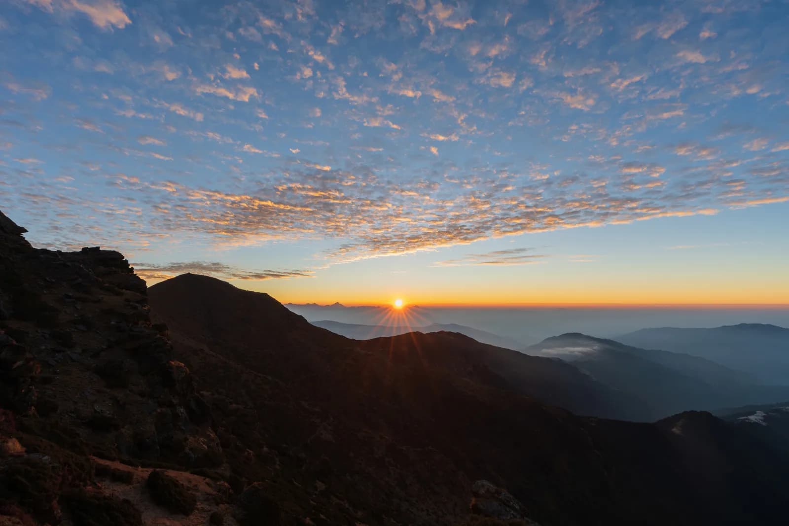
Pikey Peak Trek
A six-day trek in Solu that climbs from Dhap Bazaar through Jhapre to Pikey Peak (4,065 m) for sunrise over Everest, then descends to Junbesi and Phaplu.
- Days6
- Max altitude4,065 m
- Distance48.6 km
- Ascent2,261 m
- DifficultyModerate
- Best monthsMar–May, Sep–Nov
- Permits3
Photo: Sunuwargr · CC BY-SA 4.0
This itinerary is a draft and hasn't been verified yet. Always confirm stages with your guide.
Written by FindTrekkingPartner teamReviewed by FindTrekkingPartner teamHow we reviewFindTrekkingPartner
Pikey Peak Trek is a 6-day trek in the Solu region of Nepal that climbs to 4,065 m. Foreign trekkers can find a partner for it on FindTrekkingPartner by posting a trip with their dates, budget and pace. Matches stay private until both trekkers agree, and the service is free. At mid-range rates a licensed guide costs about USD 56 per person over 6 days when four trekkers share, against USD 224 for one trekker alone. The best seasons are Mar–May, Sep–Nov. A licensed guide is required in practice here: the Nepal Tourism Board April 2023 rule is reported by 2026 operators to be enforced at checkpoints in national parks and conservation areas, with Langtang the strictest and Annapurna checking too (checked 19 October 2026). Hire a guide through a registered agency and confirm with them. Last verified: October 19, 2026. Sources: Nepal Tourism Board, DNPWC, Department of Immigration.
Sources:Department of Immigration, NepalNepal Tourism BoardDepartment of National Parks and Wildlife Conservation
Find a partner for Pikey Peak Trek
- Find a partner for Pikey Peak TrekNo open trips yet
- Find a partner for Dudh Kunda TrekNo open trips yet
Overview
Starts from Kathmandu6 days · max 4,065 m
Best seasons: Mar–May, Sep–Nov · Permits: No restricted-area permit, Pikey Peak is outside Sagarmatha National Park, Ask your agency about any local trek card
The Pikey Peak trek is a six-day walk through the Solu part of Solukhumbu to a 4,065 m summit that gives one of the best sunrise views of Everest and the Himalaya from outside the Khumbu. A seven to nine hour drive from Kathmandu reaches Dhap Bazaar on the ridge, and the walk then goes through Jhapre and Pikey Base Camp to the summit, down to Junbesi, and along the Junbesi Khola to Phaplu, from where a drive of eight to nine hours returns to the city. The walking is about 48 km with 2,260 m of climbing and 2,790 m of descent. The trail is quieter than the Everest base camp route, passes through oak and rhododendron forest and yak pasture, and has lodges at every stop. The walk needs no flight, no restricted-area permit and no special gear beyond warm clothes for the summit sunrise.
The plan follows a KimKim itinerary and a Nepal Traveller article, which agree on the stops and the Dhap start, and it uses their heights for Jhapre, the base camp and Junbesi only where they match the elevation model. The first day on the road is long, and the second day follows a ridge road, so the real climb starts on day three. The best months are March to May and September to November. Pikey is not a restricted area and lies outside Sagarmatha National Park, so no flight and no special permit are needed.
Difficulty and fitness
The trek is moderate. The longest day is the descent from Pikey Base Camp to Junbesi, about 15 km and 1,670 m down, and the climb from Jhapre to the base camp is about 870 m. The summit climb is short but cold and dark. Good boots and trekking poles help on the descent.
Budget notes
The costs section uses Nepal-wide lodge and meal ranges by altitude, with a guide, a porter and road transport. Fares for the drives to and from Dhap and Phaplu are shown as lines to check, since we found no published prices.
What to pack
A down jacket, hat and gloves for the summit sunrise, a headlamp, rain gear, a warm sleeping bag and water treatment. Lodges give blankets, but nights at Pikey Base Camp, at about 3,640 m, are cold.
Highlights
- Sunrise from Pikey Peak at 4,065 m, with Everest and the Khumbu range in view
- Rhododendron forest, yak pasture and the Sherpa and Rai villages of Solu
- Junbesi and the Thubten Choling monastery
- A quieter alternative to the Everest base camp trail
- A road start and finish: no flight is needed
Route map
Route data from OpenStreetMap, not yet checked by our team. Use it for planning, not navigation.
Day by day
Walk about 9.4 km from Dhap Bazaar to Jhapre, four to five hours, through Sigane along a ridge road with small ups and downs. It is the easiest walking day: the climb is only 220 m, with 370 m of descent, and most of it is on a motor road, which operators describe as a forest road. Jhapre is at about 2,815 m according to KimKim and Nepalgram, and the lodges lie in a cluster below Pikey. Spend the afternoon resting, and eat early, because the next day is much longer and steeper.
You sleep 825 m higher than the night before, above the usual 500 m guideline. Take it slowly, drink plenty and watch for headache or nausea.
A day of 13 km and 870 m of climbing, five to seven hours, climbs from Jhapre along the ridge, through rhododendron and yak pasture, to Pikey Base Camp at about 3,640 m. KimKim lists lunch at Lhamuje and a time of five to six hours, and Third Rock Adventures gives six to seven. The path is mostly a footpath, with some road, and views open as you gain height. The lodge at the base camp is simple, and the night is cold. Eat well and go to bed early, because the summit is for sunrise.
Rise before dawn for the climb of about 3 km and 400 m to the summit at 4,065 m, about 1.5 to 2 hours in the dark with a headlamp, by our estimate. At sunrise, Everest and the Khumbu peaks stand above the ridges, and Hillary is said to have favoured the view. Come back to the base camp for breakfast, then walk about 12 km and 1,670 m down to Junbesi at about 2,680 m, the longest day: seven to eight hours with the summit, according to our estimate and an operator that gives eight. The route passes Jasmane Bhanjyang and forest.
Walk about 11 km from Junbesi to Phaplu in four to five hours, mostly downhill along the Junbesi Khola, with a few climbs. Phaplu is at about 2,400 m by KimKim and OpenStreetMap, and the elevation model puts it near 2,490 m. If you have spare time and energy, the Thubten Choling monastery lies a few kilometres north of Junbesi, and a round trip takes about three hours. Your lodge in Phaplu is close to the airstrip, and the town is the district's road and air hub, so it is a comfortable last night in the hills.
Drive from Phaplu to Kathmandu, a journey of about eight to nine hours. The road retraces much of the way to Kathmandu through Okhaldhunga district and over several ridges, and it is bumpy in places. Some trekkers take the short flight from Phaplu instead if the weather allows, which saves most of the day, but flights are often cancelled in cloud, so keep the road as your fallback. If you have a flight out of Nepal, leave a spare day before it.
Acclimatisation
Sleeping altitude night by night. Bars in red climb more than 500 m from the night before; rest days are marked.
- Sleeping altitude
- Gain over 500 m
- Rest day
What it costs
Estimated all-in cost per person: lodge and food by altitude, transport, permits, and the guide and porters. The more trekkers share a guide and porters, the less each person pays. As of October 2026.
| Style | 1 trekker | 2 trekkers sharing | 4 trekkers sharing |
|---|---|---|---|
| Budget | $100–$170* | $100–$170* | $100–$170* |
| Mid-range | $350–$560* | $250–$400* | $210–$340* |
| Comfort | $400–$630* | $330–$520* | $290–$460* |
Share a guide, save money
At mid-range, a solo trekker pays about $350–$560; four trekkers sharing one guide and two porters pay about $210–$340 each (39% less at the top of the range).
Breakdown for 2 trekkers sharing
| Item | Budget | Mid-range | Comfort |
|---|---|---|---|
| Lodge and food | $100–$170 | $140–$230 | $190–$300 |
| Guide | — | $70–$120 | $70–$120 |
| Porters | — | $30–$60 | $60–$110 |
Budget uses public transport and no porter; mid-range shares one porter between two trekkers and a private vehicle; comfort gives each trekker a porter. A guide is included where one is required or the style is mid-range or comfort.
Nightly lodge and food (room and a dal bhat meal)
1 night Below 2,500 m: room $2–$9, dal bhat $4–$7 · 4 nights 2,500 to 3,800 m: room $4–$11, dal bhat $5–$11
Not included
No published price found for: Kathmandu to Dhap Bazaar by road (return). Totals marked * leave these out; ask your agency. No permit applies. The return drive from Phaplu to Kathmandu is priced with the same road leg; a flight from Phaplu is an alternative with no published fare in our sources.
Cost sources
- PriceNepal: Nepal Travel Cost Guide 2026 (2026-05-14)
- Third Rock Adventures: Nepal trek budget planner (2026-05-09)
- Himalayan Partner: Guide and porter price in Nepal 2026 (2026-02-10)
- Shikhar Adventure: Annapurna Circuit trek cost (2026-02-03)
- Nepal Tourism Board: Trekking Permit (2026-10-18)
Estimates from operator guides, not quotes. Tips, insurance, gear and Kathmandu hotels are not included; USD at the platform exchange rate.
Photos
Frequently asked questions
This plan takes six days from Kathmandu to Kathmandu, with four walking days and a drive at each end. Operators sell versions of seven to eleven days, which add Kathmandu days, a side trip to Thubten Choling monastery or a night at Taksindu.
4,065 m, which is the figure on Wikipedia, on OpenStreetMap and in operator itineraries; our elevation model gives about 4,040 m. Pikey Base Camp is given as 3,585 to 3,640 m.
No restricted-area permit is needed, and the peak is outside Sagarmatha National Park, so its entry permit does not apply. Ask your agency whether any local municipality fee applies.
Yes, one common variant flies to Phaplu and walks to Junbesi and Pikey, and some plans return by air from Phaplu. Flights depend on weather, so allow spare days. Our plan drives both ways and prices road transport only.
It is a moderate trek with a high point of 4,065 m, so it suits fit beginners who accept cold mornings. The sunrise climb from the base camp is the hardest part, and the lodges give shelter at each stop.
Sources
Along the trail
Stays, medical help, water and sights on each day of the route.
1. Kathmandu → Dhap Bazaar
- Tribhuvan International Airport · Airports & transport · 1,340 m
2. Dhap Bazaar → Jhapre
- Magar Hotel Dhap · Stays · 2,998 m
- Magar Hotel and Lodge · Stays · 2,997 m
- Mountain view lodge · Stays · 2,675 m
- Number view Lama Hotel · Stays · 2,844 m
Show all 5 places
- Magar Hotel Dhap · Stays · 2,998 m
- Magar Hotel and Lodge · Stays · 2,997 m
- Mountain view lodge · Stays · 2,675 m
- Mountain view lodge & restaurant · Stays · 2,676 m
- Number view Lama Hotel · Stays · 2,844 m
3. Jhapre → Pikey Base Camp
- Pikey lodge · Stays · 2,847 m
- Guest House · Stays · 2,847 m
- Mountain view hotel · Stays · 2,919 m
- Lhamuje Lodge · Stays · 3,494 m
Show all 8 places
- Pikey lodge · Stays · 2,847 m
- Guest House · Stays · 2,847 m
- Mountain view hotel · Stays · 2,919 m
- Everest view point · Stays · 2,932 m
- Panorama View Hotel · Stays · 2,927 m
- Himalayan Lama Hotel · Stays · 2,944 m
- Bhulbule Lodge · Stays · 3,369 m
- Lhamuje Lodge · Stays · 3,494 m
4. Pikey Base Camp → Junbesi
- Lamjura La · Nature · 3,530 m
- Drinking Water · Practical · 3,195 m
- Jumbesi Home Stay · Stays · 2,749 m
- Sherpa Guide Lodge & Restaurant · Stays · 2,699 m
- Apple Garden Guest House · Stays · 2,686 m
- Ang Domi Lodge · Stays · 2,697 m
Show all 17 places
- Peakey Yak Lodge& Restaurant · Stays · 3,499 m
- Pikey Everest Lodge an Restaurant · Stays · 3,508 m
- Lamjura La · Nature · 3,530 m
- Drinking Water · Practical · 3,195 m
- Green View Hotel and Restaurant · Stays · 3,131 m
- Tashi Deleg Lodge · Stays · 3,178 m
- Shanti Chetra Lodge · Stays · 3,115 m
- Suman Lodge · Stays · 3,034 m
- Jumbesi Home Stay · Stays · 2,749 m
- Sherpa Guide Lodge & Restaurant · Stays · 2,699 m
- Apple Garden Guest House · Stays · 2,686 m
- Ang Domi Lodge · Stays · 2,697 m
- Jumbesi Valley Guest House · Stays · 2,682 m
- Ang Chhokpa’s Lodge & Restaurant · Stays · 2,689 m
- J.B. Lodge & Restaurant · Stays · 2,684 m
- Noryang Hotel · Stays · 2,700 m
- Zambala Guest House · Stays · 2,708 m
5. Junbesi → Phaplu
- Phaplu Airport · Airports & transport · 2,468 m
- Phaplu Hospital · Medical · 2,505 m
- Hotel Dream Lodge & Restaurant · Stays · 2,472 m
- Green Land Hotel & Lodge · Stays · 2,477 m
- Kirat Hotel Lodge and Restaurant · Stays · 2,482 m
- Hotel Sunshine · Stays · 2,482 m
Show all 21 places
- Sherpa Home Stay · Stays · 2,701 m
- Hotel Kunsal · Stays · 2,680 m
- Everest Lodge & Restaurant · Stays · 2,679 m
- Sagarmatha Lodge & Restaurant · Stays · 2,676 m
- Phaplu Airport · Airports & transport · 2,468 m
- Phaplu Hospital · Medical · 2,505 m
- Hotel Dream Lodge & Restaurant · Stays · 2,472 m
- Green Land Hotel & Lodge · Stays · 2,477 m
- Kirat Hotel Lodge and Restaurant · Stays · 2,482 m
- Hotel Sunshine · Stays · 2,482 m
- Rokding Hotel & Lodge · Stays · 2,479 m
- Namaste Hotel & Restaurant · Stays · 2,480 m
- Hotel Phaplu Lodge & Restaurant · Stays · 2,479 m
- Airport Hotel Lodge & Restaurant · Stays · 2,479 m
- Bijay & Bikash Hotel · Stays · 2,481 m
- Khumbila Hotel & Lodge · Stays · 2,481 m
- Hotel Everest · Stays · 2,484 m
- Thamserku Lodge & Restaurant · Stays · 2,486 m
- Sofiya Hotel & Lodge · Stays · 2,486 m
- Shangri-La Guest House · Stays · 2,486 m
- Kyirmu Lodge · Stays · 2,498 m
6. Phaplu → Kathmandu
Nothing mapped for this day yet.Nothing mapped for this day yet.
Last verified on Oct 19, 2026Report outdated info