

Drive from Kathmandu to Machha Khola, at 870 m, a jeep journey of eight to nine hours via Dhading, Arughat and Soti Khola on a rough and dusty road. The route follows the Budhi Gandaki river and the last stretch is a narrow track cut into the hillside. Landslides can cause delays in the monsoon. Machha Khola is a small village of lodges beside the river, at the start of the trail. Check your gear and permits, and rest. Tomorrow is the first full day of walking along the Budhi Gandaki gorge.
Manaslu Circuit Trek
A restricted-area circuit around Manaslu over the Larkya La, exiting via Dharapani into the Annapurna region.
- Days14
- Max altitude5,106 m
- Distance137 km
- Ascent9,203 m
- DifficultyHard
- Best monthsMar–May, Oct–Nov
- Permits4
Photo: Nabin K. Sapkota · CC BY-SA 4.0
Written by FindTrekkingPartner teamReviewed by FindTrekkingPartner teamHow we reviewFindTrekkingPartner
Manaslu Circuit Trek is a 14-day trek in the Manaslu region of Nepal that climbs to 5,106 m. Foreign trekkers can find a partner for it on FindTrekkingPartner by posting a trip with their dates, budget and pace. Matches stay private until both trekkers agree, and the service is free. At mid-range rates a licensed guide costs about USD 106 per person over 14 days when four trekkers share, against USD 423 for one trekker alone. The best seasons are Mar–May, Oct–Nov. This is a restricted area, so a licensed guide hired through a registered agency is part of the permit, and the whole group travels on one agency permit. Open trips for this route are listed below, with start month, group size and spots left. Last verified: October 19, 2026. Sources: Nepal Tourism Board, DNPWC, Department of Immigration.
Sources:Department of Immigration, NepalNepal Tourism BoardDepartment of National Parks and Wildlife Conservation
Find a partner for Manaslu Circuit Trek
- Find a partner for Manaslu Circuit Trek4 open trips
- Find a partner for Tsum Valley TrekNo open trips yet
Overview
Starts from KathmanduPasses: Larkya La14 days · max 5,106 m
Best seasons: Mar–May, Oct–Nov · Permits: Restricted Area Permit (Department of Immigration, via a registered agency), Manaslu Conservation Area permit, Annapurna Conservation Area permit, TIMS card where required
The Manaslu Circuit follows the Budhi Gandaki river north from Machha Khola through Jagat, Deng, Namrung and Lho to Samagaun, climbs to Samdo and Dharamsala, crosses the Larkya La at 5,106 m, and descends to Bimthang and Tilije before meeting the Annapurna Circuit at Dharapani. This 14-day plan starts with a jeep ride from Kathmandu and ends with a drive from Besisahar. The route lies in a restricted area, so it requires a permit from the Department of Immigration and a licensed guide, and it is far quieter than the Annapurna or Everest trails. Lodges are simpler, days are long and the pass is a serious crossing. In return you see Manaslu from several angles and cultures that are almost entirely Tibetan in the upper valley. It suits experienced trekkers who accept long days and basic lodges, and who will book through a registered agency for the restricted-area permit and guide.
What the trek is like
The first three days follow the Budhi Gandaki gorge, with suspension bridges, landslide scars and subtropical forest. Above Deng the valley turns north and the first Tibetan-style villages appear, with mani walls, chortens and monasteries; Namrung and Lho have fine gompas. Beyond Lho the valley opens to Samagaun and the view of Manaslu, which fills the horizon. Samdo is a high trading village close to the Tibetan border. From Dharamsala the Larkya La climb is on moraine and snow, with an icy descent into Bimthang, a broad valley with views of Manaslu's western face.
Highlights
- The Budhi Gandaki gorge and its suspension bridges
- Lho, Samagaun and the view of Manaslu
- Pungyen Gompa and Birendra Lake on rest days
- Samdo, a Tibetan trading village near the border
- Larkya La at 5,106 m and the descent to Bimthang
Permits and rules
You need a Restricted Area Permit (RAP) from the Department of Immigration, Manaslu Conservation Area and Annapurna Conservation Area permits, and a TIMS card where required, all arranged by a registered agency. A licensed guide must accompany you at all times. Since 22 March 2026 one trekker can apply, so a group of two is no longer needed; the agency and guide requirement remains, and a partner halves the guide cost. Check current permit costs and rules with the agency or the Department of Immigration.
Best season
October and November have the most stable weather, and March to May is also good. The pass is usually clear in May and in October to early November. Avoid the monsoon and winter, when snow on Larkya La makes crossing hazardous.
Acclimatisation
The plan includes two rest days: one at Samagaun and one at Samdo. Use them for day hikes to Pungyen Gompa, Birendra Lake or toward Manaslu Base Camp, and sleep low. Sleep at Dharamsala before the pass. If anyone has symptoms of altitude sickness, descend or rest. A spare day before the pass is helpful if the weather is poor.
The pass day
The crossing begins before dawn from Dharamsala (about 4,470 m), climbs on moraine and snow to Larkya La, and descends steeply to Bimthang (about 3,720 m). It takes eight to ten hours. The top is cold and windy, with views of Manaslu, Himlung Himal and Cho Danda. Carry warm gloves, goggles and microspikes, and keep your group together.
Getting there and away
Jeep from Kathmandu to Machha Khola takes 8 to 9 hours on a rough road. After the trek, a jeep from Tilije or Dharapani takes you to Besisahar, and from there it is 6 to 7 hours to Kathmandu.
Lodges, food and costs
Lodges are simple, with limited menus above Namrung. Rooms are cheap if you eat at the lodge, and prices rise with remoteness. Carry cash and snacks.
Packing list
Waterproof boots, warm layers, down jacket, insulated gloves, hat, sunglasses or goggles, microspikes, a sleeping bag rated to about -15 C, trekking poles, headlamp, water purification and a first-aid kit.
Who this trek suits and how to prepare
The circuit suits experienced trekkers who are comfortable with long days, basic lodges and a high pass. Prepare for three months with long hill walks, stair climbing and, if possible, a previous high-altitude trek. Practise using microspikes and trekking poles. Mental preparation matters: remote conditions, cold nights and a long pass day can be tiring.
The plan at a glance
Day 1 drives to Machha Khola (870 m), and days 2 to 6 follow the Budhi Gandaki through Jagat, Deng, Namrung and Lho to Samagaun (3,530 m). Day 7 is a rest day with a hike. Day 8 reaches Samdo (3,875 m), and day 9 is a second rest day. Day 10 reaches Dharamsala (4,470 m), and day 11 crosses Larkya La to Bimthang. Day 12 descends to Tilije, day 13 walks to Dharapani and drives to Besisahar, and day 14 drives to Kathmandu.
The restricted-area process
Because the route is a restricted area, your agency applies for the Restricted Area Permit, usually a few days before you travel, and needs your passport, photos and visa. Allow extra time in Kathmandu for the paperwork. Permit checks happen at Jagat, Philim and Samagaun, so carry copies. If the rules change, your agency will update you.
Practical tips from the trail
- Carry spare cash and snacks, because supplies are limited above Namrung.
- Look after your feet on the long days; wear liners and change socks.
- Check the weather and snow on Larkya La with lodge owners and other groups.
- Wear a windproof layer, goggles and gloves on the pass.
- Respect the villagers' customs, and ask before photographing.
Responsible trekking
Carry out all your waste, use purification tablets instead of bottled water and support family-run lodges. Treat your guide and porters well, and avoid disturbing wildlife.
Highlights
- Budhi Gandaki gorge
- Lho and Samagaun views of Manaslu
- Pungyen Gompa and Birendra Lake
- Samdo Tibetan trading village
- Larkya La at 5,106 m
Route map
Route data from OpenStreetMap, not yet checked by our team. Use it for planning, not navigation.
Day by day
Follow the Budhi Gandaki upstream, crossing suspension bridges and passing through Khorlabesi, Tatopani, where a hot spring sits beside the river, and Doban. The trail climbs and descends along the gorge, with views of waterfalls and terraced fields. After Doban, the path climbs to Jagat, at 1,340 m, a village with a checkpoint where your Restricted Area Permit is inspected. It is a long day of six to seven hours with ups and downs. Keep your permits and passport handy. Jagat has a number of lodges, and the evening is warm.
You sleep 520 m higher than the night before, above the usual 500 m guideline. Take it slowly, drink plenty and watch for headache or nausea.
Climb out of Jagat through Salleri and Sirdibas to Philim, a large Gurung village with views of the valley, where the trail to the Tsum Valley branches off. Continue through bamboo forest and along the gorge to Deng, at 1,860 m, crossing the river several times on suspension bridges. It is a six- to seven-hour day with a steady climb. The valley narrows, and landslides sometimes affect the trail. Deng is a small settlement with a few lodges. Drink plenty of water and rest. The culture begins to change from Gurung to Tibetan here.
You sleep 770 m higher than the night before, above the usual 500 m guideline. Take it slowly, drink plenty and watch for headache or nausea.
Cross the river and climb steeply through forest to Bhi and the villages of Ghap and Lihi, where you first see mani walls and chortens in the Tibetan style. Continue along the gorge to Namrung, at 2,630 m, passing through bamboo and rhododendron forest. The trail is a mix of steep climbs and level stretches. Namrung has a checkpoint where your permits are checked, and the village has a small monastery. It is a long day of six to seven hours. The view of the Siringi Himal appears as the valley opens.
You sleep 540 m higher than the night before, above the usual 500 m guideline. Take it slowly, drink plenty and watch for headache or nausea.
Climb through forest to Lihi and Sho, a village with views of Manaslu in clear weather, then continue to Lho, at 3,170 m, a large village with a fine monastery above the houses and a view of Manaslu. The path passes through juniper and rhododendron, and the landscape becomes more open. The altitude is now noticeable, so walk slowly and drink water. Lho has several lodges, and the view of Manaslu at sunset is a highlight. It is a short day of four to five hours. Rest and enjoy the evening.
Walk through the village of Shyala, with views of Himalchuli and Ngadi Chuli, and across the open valley to Samagaun, at 3,530 m, the largest village in the upper valley. Samagaun is a Tibetan-influenced village of stone houses with a monastery and views of Manaslu. The altitude is now significant, so rest and drink plenty. In the afternoon, walk to the monastery or around the village. It is a short day of three to four hours, and it prepares you for tomorrow's acclimatisation hike. Samagaun has several lodges.
A rest and acclimatisation day at Samagaun. Choose a hike: climb to Pungyen Gompa, a monastery above the village at about 3,870 m, with views of Manaslu and its glacier, or walk to Birendra Lake, a glacial lake at the foot of the Manaslu glacier. A longer option is to walk toward Manaslu Base Camp, at about 4,800 m, but go only as far as you feel comfortable. Return to sleep at Samagaun. Spend the afternoon resting, washing and eating well. Check your gear for the pass.
Walk from Samagaun through the juniper valley and across a river, along the valley floor to Samdo, at 3,875 m, a Tibetan trading village close to the border. The path is gentle, with views of Manaslu and the Larkya glacier. Samdo has a small monastery and a number of lodges, and the villagers have traded with Tibet for centuries. It is a short day of three to four hours. In the afternoon, walk up the hill behind the village for acclimatisation and views of the valley. Drink water and rest.
A second rest and acclimatisation day, at Samdo. Take a short hike up the ridge toward the Tibetan border or to a viewpoint above the village, then return to sleep. The day gives your body time to adjust before the pass, and it is a good chance to talk with your guide about the weather and conditions on Larkya La. Spend the afternoon resting, drinking and eating. Check your gloves, hat, goggles and microspikes. If anyone is unwell, consider a spare day here.
You sleep 595 m higher than the night before, above the usual 500 m guideline. Take it slowly, drink plenty and watch for headache or nausea.
Climb from Samdo across the valley and along the moraine to Dharamsala, also called Larkya Phedi, at about 4,470 m, a stone shelter and a few lodges at the foot of the pass. The path crosses a river and climbs gently, with views of Larkya Peak and the glacier. It is a short day of four hours, but the altitude is high, so walk slowly. Rest, eat and go to bed early; tomorrow starts well before dawn. The lodges are basic and cold. Watch for symptoms of altitude sickness.
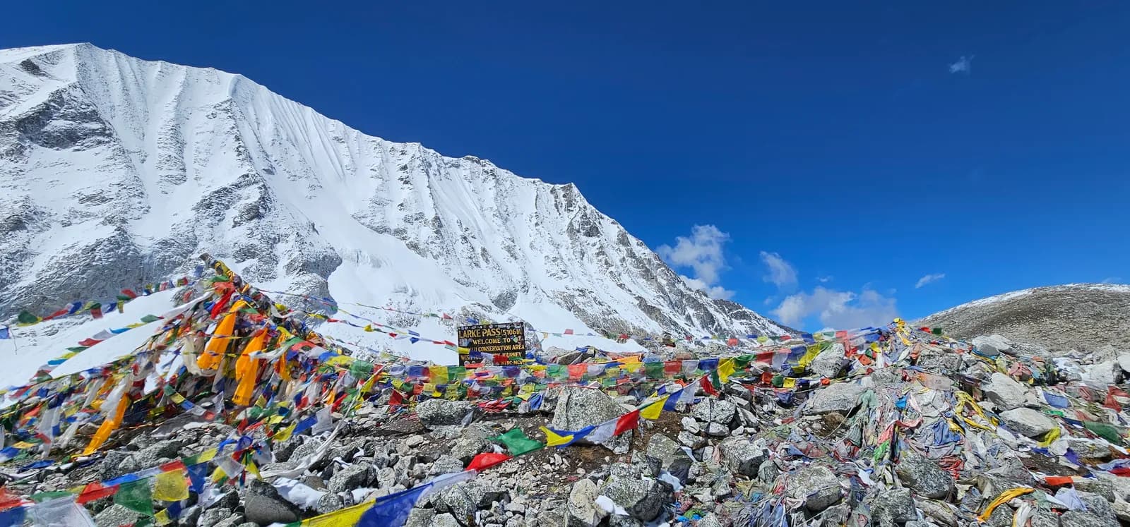
Start before dawn and climb steeply on moraine and snow to the top of Larkya La, at 5,106 m, with prayer flags and views of Manaslu, Himlung Himal and Cho Danda. The climb takes three to four hours, and the top is cold and windy. The descent is steep and icy, with a long moraine slope and a rocky path, to Bimthang, at about 3,720 m, a broad valley with views of Manaslu's western face. It is a very long day of eight to ten hours. Keep your group together and turn back if the weather turns.
Descend from Bimthang through rhododendron and pine forest, passing yak pastures, to Gho and Tilije, at about 2,300 m. The path follows the Dudh Khola and drops steeply through forest, with views of Manaslu behind you. The warmth and the thicker air are welcome after the pass. It is a five- to six-hour day with a steep descent, so use poles. Tilije has a few lodges and the road starts nearby. Rest, wash and eat well. You are now in the Annapurna Conservation Area.
Walk down the valley to Dharapani, at 1,860 m, where the Manaslu trail meets the Annapurna Circuit, a walk of about three hours. From here, a jeep takes you down the Marsyangdi valley to Besisahar, at 760 m, a drive of about three hours on a rough road. Besisahar is a busy town with shops and lodges. Have a hot shower, a good meal and a rest. Pay your guide and porters, and have a farewell dinner. Tomorrow is a long drive to Kathmandu.
You sleep 640 m higher than the night before, above the usual 500 m guideline. Take it slowly, drink plenty and watch for headache or nausea.
Drive from Besisahar to Kathmandu, a journey of six to seven hours along the Marsyangdi and Trishuli rivers, on a busy road. Start early to avoid delays. In Kathmandu, shower, repack and reflect on the trek. If you have time, visit Boudhanath or Pashupatinath, or shop in Thamel. Do not schedule an international flight for the same evening, because the road can be slow. Confirm that your permits and passport are in order, and thank your guide and porters for their help.
Acclimatisation
Sleeping altitude night by night. Bars in red climb more than 500 m from the night before; rest days are marked.
- Sleeping altitude
- Gain over 500 m
- Rest day
What it costs
Estimated all-in cost per person: lodge and food by altitude, transport, permits, and the guide and porters. The more trekkers share a guide and porters, the less each person pays. As of October 2026.
| Style | 1 trekker | 2 trekkers sharing | 4 trekkers sharing |
|---|---|---|---|
| Budget | $840–$1,250 | $670–$970 | $580–$850 |
| Mid-range | $1,400–$2,100 | $1,000–$1,500 | $840–$1,250 |
| Comfort | $1,550–$2,250 | $1,200–$1,800 | $1,050–$1,550 |
Share a guide, save money
At mid-range, a solo trekker pays about $1,400–$2,100; four trekkers sharing one guide and two porters pay about $840–$1,250 each (41% less at the top of the range).
Breakdown for 2 trekkers sharing
| Item | Budget | Mid-range | Comfort |
|---|---|---|---|
| Lodge and food | $290–$460 | $390–$610 | $520–$780 |
| Transport | $10–$40 | $160–$230 | $160–$230 |
| Permits | $180–$240 | $180–$240 | $180–$240 |
| Guide | $170–$250 | $170–$250 | $170–$250 |
| Porters | — | $90–$160 | $180–$310 |
Budget uses public transport and no porter; mid-range shares one porter between two trekkers and a private vehicle; comfort gives each trekker a porter. A guide is included where one is required or the style is mid-range or comfort.
Nightly lodge and food (room and a dal bhat meal)
5 nights Below 2,500 m: room $2–$9, dal bhat $4–$7 · 5 nights 2,500 to 3,800 m: room $4–$11, dal bhat $5–$11 · 3 nights Above 3,800 m: room $7–$19, dal bhat $8–$13
Permit fees (official sources)
Cost sources
- PriceNepal: Nepal Travel Cost Guide 2026 (2026-05-14)
- Third Rock Adventures: Nepal trek budget planner (2026-05-09)
- Himalayan Partner: Guide and porter price in Nepal 2026 (2026-02-10)
- Shikhar Adventure: Annapurna Circuit trek cost (2026-02-03)
- Nepal Tourism Board: Trekking Permit (2026-10-18)
Estimates from operator guides, not quotes. Tips, insurance, gear and Kathmandu hotels are not included; USD at the platform exchange rate.
Photos
Frequently asked questions
Hard. Days are long, lodges are basic and the Larkya La crossing is a serious high-altitude day.
Fourteen days from Kathmandu on this plan, including two rest days.
Yes: a Restricted Area Permit through a registered agency and a licensed guide. Reports say individuals can apply since March 2026; confirm the current rule.
Larkya La is 5,106 m.
October and November, and March to May.
It is not recommended: rain, landslides and cloud affect the lower valley, and the road is often closed.
Sources
Along the trail
Stays, medical help, water and sights on each day of the route.
1. Kathmandu → Machha Khola
- Tribhuvan International Airport · Airports & transport · 1,340 m
2. Machha Khola → Jagat
- Hot Springs · Nature · 816 m
- Viewpoint of Ganesh Himal & landslide area · Viewpoints · 944 m
- Punngpu · Nature · 1,310 m
- Himalayan Tourist Guest House · Stays · 1,335 m
- Manaslu Shani Hotel & Lodge · Stays · 1,353 m
- Jagat Guest House · Stays · 1,346 m
- Rubinala Inn · Stays · 1,340 m
Show all 22 places
- Hotel Chumvally Restaurant and Lodge · Stays · 862 m
- Hotel Hilltop · Stays · 857 m
- Manaslu Hotel & Lodge · Stays · 859 m
- Hot Springs · Nature · 816 m
- Mt. Everest Hotel · Stays · 879 m
- Shangri La Hotel · Stays · 890 m
- Sem Jang Ganesh Hotel · Stays · 888 m
- River View Guest House · Stays · 881 m
- Sangri La Hotel · Stays · 884 m
- Viewpoint of Ganesh Himal & landslide area · Viewpoints · 944 m
- 18 Saya Khola Family Guest House · Stays · 987 m
- Royal Mountain Hotel & Lodge · Stays · 984 m
- Budhi Gandaki Valley Gusethouse · Stays · 983 m
- Thulodhunga Hotel and Lodge · Stays · 1,146 m
- Punngpu · Nature · 1,310 m
- Yaru Guest House · Stays · 1,326 m
- Hosanna · Stays · 1,300 m
- Yuru Khola · Stays · 1,279 m
- Himalayan Tourist Guest House · Stays · 1,335 m
- Manaslu Shani Hotel & Lodge · Stays · 1,353 m
- Jagat Guest House · Stays · 1,346 m
- Rubinala Inn · Stays · 1,340 m
3. Jagat → Deng
- Jagat Health Unit · Medical · 1,335 m
- Mongolian cottage · Stays · 1,334 m
- Shrinki Guest House · Stays · 1,336 m
- Viewpoint · Viewpoints · 1,978 m
- Hotel Windy Valley & Garden · Stays · 1,873 m
- Namgyal Guest House · Stays · 1,884 m
Show all 17 places
- Jagat Health Unit · Medical · 1,335 m
- Mongolian cottage · Stays · 1,334 m
- Shrinki Guest House · Stays · 1,336 m
- Royal Guest House · Stays · 1,574 m
- Philim village and lodge · Stays · 1,570 m
- Hulchuki hotel and restaurant · Stays · 1,564 m
- Gorkha view hotel · Stays · 1,562 m
- Laprak Gurung Bamboo Cottage & Restaurant · Stays · 1,633 m
- Chum Nubri Ekle Bhatti Chisopi Guest House · Stays · 1,633 m
- Ekelebhatti Long Bridge Guest House & Restaurant · Stays · 1,611 m
- Akley Bhatti Hotel & Lodge · Stays · 1,620 m
- Kham-Sangbo Hotel & Lodge · Stays · 1,801 m
- Nyak Phedi Guest House · Stays · 1,681 m
- Viewpoint · Viewpoints · 1,978 m
- New Pewa Guest House · Stays · 2,002 m
- Hotel Windy Valley & Garden · Stays · 1,873 m
- Namgyal Guest House · Stays · 1,884 m
4. Deng → Namrung
- Health Post · Medical · 2,135 m
- Nubri Four Season Resort · Stays · 2,616 m
- Namrung Tibetan Guest House · Stays · 2,604 m
- Namrung Guest House · Stays · 2,617 m
- The River View Cottage · Stays · 2,599 m
Show all 19 places
- Manaslu Bamboo Hotel · Stays · 1,887 m
- Shangrila Home · Stays · 1,869 m
- Karma Hotel · Stays · 1,998 m
- Hotel Singla Guest house · Stays · 2,006 m
- Gapkaltal Guest House · Stays · 1,984 m
- 500 a Night · Stays · 1,981 m
- Bur Guest House · Stays · 2,090 m
- The Bur Guest House · Stays · 2,090 m
- Budhi Gandaki Hotel · Stays · 2,109 m
- Ghap Cottage Guest House · Stays · 2,133 m
- Gap Cottage · Stays · 2,135 m
- Health Post · Medical · 2,135 m
- Hotel Kyimolung · Stays · 2,161 m
- Jungle Hotel K.L.S.P · Stays · 2,251 m
- Organic Apple Farme Guest House · Stays · 2,545 m
- Nubri Four Season Resort · Stays · 2,616 m
- Namrung Tibetan Guest House · Stays · 2,604 m
- Namrung Guest House · Stays · 2,617 m
- The River View Cottage · Stays · 2,599 m
5. Namrung → Lho
- Huge waterfall · Nature · 2,642 m
- Lhaptang Guest House · Stays · 2,647 m
- Himal chuli hotel · Stays · 2,825 m
- Hotel Sherpa Lodge & Café - Magasin · Stays · 2,911 m
- Hotel Blue Sky · Stays · 3,169 m
Show all 11 places
- Huge waterfall · Nature · 2,642 m
- Lhaptang Guest House · Stays · 2,647 m
- Himal chuli hotel · Stays · 2,825 m
- Hotel Sherpa Lodge & Café - Magasin · Stays · 2,911 m
- Tashi Delek Lodge · Stays · 2,940 m
- Buddhi Gandaki Homestay and Teahouse · Stays · 2,998 m
- New hotel Himalaya · Stays · 2,982 m
- Norgyun Hotel · Stays · 3,012 m
- Zambala Manaslu Sho Guest House · Stays · 3,036 m
- Hamra Khaja Ghar Hotel · Stays · 3,036 m
- Hotel Blue Sky · Stays · 3,169 m
6. Lho → Samagaun
- Hill-top viewpoint towards Manaslu · Viewpoints · 3,328 m
- Namasté Guest House · Stays · 3,506 m
- Yetti · Stays · 3,510 m
- Shanti Guest House · Stays · 3,510 m
- The Happiness Guest House · Stays · 3,514 m
Show all 11 places
- Majestic Manaslu Cottages & Garden · Stays · 3,178 m
- Tashi Delek Hotel & Lodge · Stays · 3,176 m
- Lama Guest House · Stays · 3,187 m
- Lho Norbu Hotel · Stays · 3,199 m
- Hill-top viewpoint towards Manaslu · Viewpoints · 3,328 m
- Namasté Guest House · Stays · 3,506 m
- Yetti · Stays · 3,510 m
- Shanti Guest House · Stays · 3,510 m
- The Happiness Guest House · Stays · 3,514 m
- Royal Ghorka hotel and sharing idea cafe · Stays · 3,515 m
- Nubri Shyala Guest House · Stays · 3,515 m
7. Samagaun
Nothing mapped for this day yet.Nothing mapped for this day yet.8. Samagaun → Samdo
- Birendra Lake · Nature · 3,635 m
- Little Tibet · Stays · 3,852 m
- Cheese Karsay Lodge · Stays · 3,854 m
- Yak Hotel · Stays · 3,845 m
- Zambala Hotel · Stays · 3,855 m
Show all 17 places
- Tashi Delek Hotel · Stays · 3,522 m
- Samsgaun Hotel & Lodge · Stays · 3,528 m
- Peace Heaven Hotel & Lodge · Stays · 3,529 m
- Tashi Yangchen Hotel & Lodge · Stays · 3,530 m
- Norling · Stays · 3,527 m
- Mount Manaslu Lodge · Stays · 3,530 m
- Hotel Base Camp · Stays · 3,528 m
- Boddhisattva Hotel & Lodge · Stays · 3,530 m
- Joyful Hotel · Stays · 3,532 m
- Mandala Hotel · Stays · 3,532 m
- Birendra Lake · Nature · 3,635 m
- Little Tibet · Stays · 3,852 m
- Cheese Karsay Lodge · Stays · 3,854 m
- Yak Hotel · Stays · 3,845 m
- Zambala Hotel · Stays · 3,855 m
- New Tashi Deleg · Stays · 3,851 m
- Hotel SnowLion · Stays · 3,851 m
9. Samdo
Nothing mapped for this day yet.Nothing mapped for this day yet.10. Samdo → Dharamsala
- Larke Bazaar Hotel · Stays · 3,920 m
- Mt. Manaslu View · Viewpoints · 4,327 m
- Larke La Hotel & Lodge · Stays · 4,459 m
11. Dharamsala → Bimthang
- Viewpoint · Viewpoints · 4,848 m
- Drinking Water · Practical · 4,387 m
- Ponkar lake · Nature · 4,091 m
- Hotel Gangar Manaslu & Restaurant · Stays · 3,717 m
- Ponkar Ganga Hotel · Stays · 3,700 m
- Sushma Hotel & Restaurant · Stays · 3,705 m
- Cheers Lilita Hotel & Restaurant · Stays · 3,707 m
Show all 12 places
- Zambala Hotel · Stays · 4,474 m
- Peace Lodge · Stays · 4,478 m
- Viewpoint · Viewpoints · 4,848 m
- Drinking Water · Practical · 4,387 m
- Gurungseni Hotel and Restaurant · Stays · 4,389 m
- 6G Brothers Hotel & Restaurant · Stays · 4,387 m
- Kusang Hotel & Restaurant · Stays · 4,377 m
- Ponkar lake · Nature · 4,091 m
- Hotel Gangar Manaslu & Restaurant · Stays · 3,717 m
- Ponkar Ganga Hotel · Stays · 3,700 m
- Sushma Hotel & Restaurant · Stays · 3,705 m
- Cheers Lilita Hotel & Restaurant · Stays · 3,707 m
12. Bimthang → Tilije
- Small waterfall · Nature · 2,992 m
- The North Face · Stays · 2,266 m
- Tibetan hotel · Stays · 2,274 m
- Napa Valley · Stays · 2,269 m
- Tilche Village Hotel · Stays · 2,261 m
Show all 13 places
- Purdi Himalayan Seven Sister Hotel · Stays · 3,045 m
- Himlung Hotel & Restaurant · Stays · 3,042 m
- Small waterfall · Nature · 2,992 m
- 7 Sisters Guest House · Stays · 2,711 m
- New Himalayan cottage · Stays · 2,703 m
- Nirvana Garden · Stays · 2,529 m
- Larke Peak Guest House & Restaura · Stays · 2,527 m
- Hotel Super View & Restaurant · Stays · 2,514 m
- Manaslu hotel · Stays · 2,495 m
- The North Face · Stays · 2,266 m
- Tibetan hotel · Stays · 2,274 m
- Napa Valley · Stays · 2,269 m
- Tilche Village Hotel · Stays · 2,261 m
13. Tilije → Besisahar
- Viewpoint · Viewpoints · 1,921 m
- Crystal Guest House · Stays · 1,825 m
- Hayat Guest House · Stays · 1,818 m
- Hotel Gurkha's Inn & Restaurant · Stays · 1,816 m
- Manaslu Hotel Restaurant · Stays · 1,820 m
- Hayenga Waterfall · Nature · 2,053 m
Show all 19 places
- Hotel Tilche · Stays · 2,263 m
- River view · Stays · 2,257 m
- Monastery Home stay · Stays · 2,203 m
- Hotel California · Stays · 1,923 m
- Viewpoint · Viewpoints · 1,921 m
- 3 Sister Guest House · Stays · 1,887 m
- Kangaroo · Stays · 1,882 m
- Dafne Hotel · Stays · 1,881 m
- Kingfisher · Stays · 1,874 m
- Gyasumda Hotel & Restaurant · Stays · 1,877 m
- Peaceful Hotel · Stays · 1,876 m
- Crystal Guest House · Stays · 1,825 m
- Hayat Guest House · Stays · 1,818 m
- Hotel Gurkha's Inn & Restaurant · Stays · 1,816 m
- Manaslu Hotel Restaurant · Stays · 1,820 m
- Hayenga Waterfall · Nature · 2,053 m
- Tashi Delek Hotel · Stays · 1,809 m
- Phulbari Hostel & Restaurant · Stays · 1,823 m
- Manaslu Guest House · Stays · 1,813 m
14. Besisahar → Kathmandu
Nothing mapped for this day yet.Nothing mapped for this day yet.
Last verified on Oct 19, 2026Report outdated info