

Drive west from Pokhara along the Baglung road to Beni, the Myagdi district town where the Myagdi Khola meets the Kali Gandaki, at about 830 m. Operators allow four to five hours, depending on traffic and road repairs. Meet your guide, cook and porters here if the crew has not travelled with you, repack the loads and make a last check of boots, poles, spikes and sleeping bag. Buy snacks and batteries now, because nothing is sold above the road. The distance is short, so you arrive with the afternoon free to stretch your legs along the river and sort out any rental gear before the long camping stretch begins.
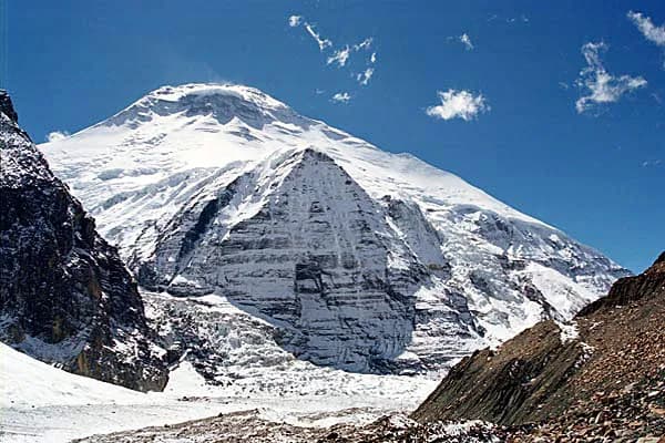
Dhaulagiri Circuit
A 17-day camping circuit from Pokhara: up the Myagdi Khola to Dhaulagiri Base Camp, over French Pass into the Hidden Valley and over Dhampus Pass to Marpha and Jomsom.
- Days17
- Max altitude5,360 m
- Distance117 km
- Ascent8,239 m
- DifficultyHard
- Best monthsMar–May, Oct–Nov
- Permits2
Photo: blackseav · CC BY 3.0
This itinerary is a draft and hasn't been verified yet. Always confirm stages with your guide.
Written by FindTrekkingPartner teamReviewed by FindTrekkingPartner teamHow we reviewFindTrekkingPartner
Dhaulagiri Circuit is a 17-day trek in the Dhaulagiri region of Nepal that climbs to 5,360 m. Foreign trekkers can find a partner for it on FindTrekkingPartner by posting a trip with their dates, budget and pace. Matches stay private until both trekkers agree, and the service is free. At mid-range rates a licensed guide costs about USD 159 per person over 17 days when four trekkers share, against USD 634 for one trekker alone. The best seasons are Mar–May, Oct–Nov. A licensed guide is required in practice here: the Nepal Tourism Board April 2023 rule is reported by 2026 operators to be enforced at checkpoints in national parks and conservation areas, with Langtang the strictest and Annapurna checking too (checked 19 October 2026). Hire a guide through a registered agency and confirm with them. Last verified: October 19, 2026. Sources: Nepal Tourism Board, DNPWC, Department of Immigration.
Sources:Department of Immigration, NepalNepal Tourism BoardDepartment of National Parks and Wildlife Conservation
Find a partner for Dhaulagiri Circuit
- Find a partner for Dhaulagiri CircuitNo open trips yet
Overview
Starts from PokharaPasses: French Pass, Dhampus Pass17 days · max 5,360 m
Best seasons: Mar–May, Oct–Nov · Permits: Annapurna Conservation Area Project (ACAP) entry permit, TIMS card issued through a registered agency
The Dhaulagiri Circuit is a 17-day camping trek that walks right around the Dhaulagiri massif, starting in the Myagdi valley beyond Beni and finishing in the Kali Gandaki valley at Marpha and Jomsom. It drives from Pokhara to Beni and follows the Myagdi Khola through Babiachaur, Dharapani, Muri, Boghara and Dobang, and climbs through Choriban Khola to Italian Base Camp at about 3,660 m. After a rest day it crosses the moraine via Glacier Camp to Dhaulagiri Base Camp at about 4,740 m, rests again, then crosses French Pass (about 5,360 m) to the Hidden Valley and Dhampus Pass (about 5,240 m) to Yak Kharka and Marpha. It covers about 117 km on foot with about 8,200 m of climbing, following three operator itineraries. It is hard: unsupplied camps, glacier travel, passes above 5,200 m and nights near minus 15 degrees. Spring and autumn are the seasons.
What the trek is like
The first three days are the gentlest: a jeep road and farmland along the Myagdi Khola, with Magar villages and terraced fields. From Muri the trail steepens into forest, and above Dobang it leaves the last settlement behind. From then until Marpha you sleep in tents, and the crew carries everything. The two base-camp sections follow rock and moraine beneath the vertical north face of Dhaulagiri and the neighbouring summits.
Permits and rules
You need the ACAP entry permit and a TIMS card, both of which your agency arranges. The Circuit is not a restricted area and has no minimum group size, but the route is unsupplied and glaciated, so treat a guide and crew as mandatory in practice. The pass days can be stopped by weather: your guide decides, and you should carry insurance that covers evacuation by helicopter.
Best season
Late March to early May and October to mid-November. Operators advise against the monsoon and winter, and say snow, wind and whiteout are possible on the passes even in season. The Hidden Valley can fall to minus 15 to minus 25 degrees Celsius at night.
Altitude
You sleep above 3,000 m on seven nights, above 4,000 m on four and at about 5,100 m on the Hidden Valley night. The two rest days at Italian Base Camp and Dhaulagiri Base Camp are essential, and the descent route from the high camps is back down the valley, not over the pass, if someone is sick.
Getting there and away
Pokhara to Beni is a four-to-five-hour drive. The trek ends at Jomsom, where the morning flight to Pokhara takes about 20 minutes but is often delayed by wind; keep one spare day or plan a jeep.
Lodges, food and costs
All camps are tented and the agency cooks. Costs are quoted by the agency; see the sourced permit fees and sample totals in the costs section.
Gear notes
Bring micro-spikes or light crampons and poles for the glacier and the Dhampus descent, a down jacket, a sleeping bag for minus 15 degrees and a pair of gaiters. Some operators also pack a light ice axe.
Extensions
From Marpha you can continue up the Kali Gandaki to Muktinath, or catch the flight from Jomsom and finish in Pokhara. The Hidden Valley also gives access to Dhampus Peak (about 6,000 m) for climbers with the right permit and experience, which is outside this plan.
Highlights
- Dhaulagiri Base Camp at about 4,740 m, under the north face of the world's seventh-highest peak
- French Pass (about 5,360 m) and the Hidden Valley beyond it
- Dhampus Pass and the long descent to the Kali Gandaki valley
- Marpha, the apple village of Mustang, and a flight out of Jomsom
- A quiet, fully supported camping trek far from the teahouse circuits
Route map
Route data from OpenStreetMap, not yet checked by our team. Use it for planning, not navigation.
Day by day
The first walking day starts on the jeep road up the Myagdi Khola, about 12 km on our mapped route with only a small net rise, and takes 5 to 6 hours in operator itineraries. The valley is wide and warm, with rice and millet terraces, bamboo groves, suspension bridges and Magar farmhouses. Babiachaur, at about 950 m by operator figures, is a roadside settlement where the crew pitches the first camp near the river. It is a gentle warm-up: use it to find a pace you could keep for six hours, drink steadily and get used to camp routine.
A longer second stage of 5 to 6 hours takes you to Dharapani (Myagdi), at about 1,400 m. On our mapped route it is about 17 km with roughly 1,200 m of climbing, mostly on the jeep road above the Myagdi Khola, and you cross side streams on suspension bridges. Villages, millet fields and stone houses line the way. The crew sets up camp near the village. Do not confuse this Dharapani with the one on the Annapurna Circuit; this one is a Magar settlement in the Myagdi valley.
The trail leaves the last farmland and climbs through forest above the river, with the first views of snow peaks opening on clear mornings. Muri, at about 1,800 m, is the last village of any size on the circuit, and Peregrine Treks calls this the most challenging of the early days because of the steady climbing, about 5 hours for 13 km on our route. Camp near the village. If you have an upset stomach or a problem with your boots, this is the last easy place to sort it out before the trail narrows into the gorge.
From Muri the path follows the Myagdi Khola into a deeper gorge, crossing and recrossing the river on bridges and climbing steeply in places. The forest closes in around you, with rhododendron and oak overhead and wet ground underfoot. Operators allow 5 to 6 hours for the 10 km to Boghara, at about 2,080 m, where the camp sits among trees close to the river. You gain and lose several hundred metres on the way, so pace yourself and keep the porters' loads in mind: the crew is carrying everything you will use for the next ten days.
The valley steepens and the path crosses side streams and passes waterfalls on the way to Dobang, at about 2,520 m. It is about 9 km and operators give 5 hours, with a gain of nearly 1,000 m through bamboo forest. Dobang is a wilderness campsite with no building, so from now on the crew cooks every meal. It is also the first night where the cold starts to bite. Keep dry layers for the evening, drink plenty of water and watch for headaches, which show whether you have climbed too fast.
You sleep 590 m higher than the night before, above the usual 500 m guideline. Take it slowly, drink plenty and watch for headache or nausea.
Climb a rocky trail and cross landslide-scarred slopes where the forest thins to juniper and shrubs. Choriban Khola, at about 3,110 m, is a campsite beside a stream, 5 to 6 km further and about 5 hours in operator itineraries, with a gain of about 780 m. This is your first night above 3,000 m and the first clear views of Dhaulagiri. The slopes above the trail are steep, so move steadily through exposed sections and do not stop under them. Eat and drink well in the evening, even if your appetite is dulled by the height.
You sleep 550 m higher than the night before, above the usual 500 m guideline. Take it slowly, drink plenty and watch for headache or nausea.
A short but tiring stage over rocky moraine and boulder fields takes you to Italian Base Camp at about 3,660 m. On our route it is only 3.7 km with a climb of about 470 m, but every operator allows around 7 hours because of the rough ground and the altitude, so do not judge the day by distance. The north face of Dhaulagiri finally comes into view. The camp is a flat meadow with streams, a classic spot for the first big acclimatisation rest. Arrive early, rest, and have your guide check how everyone feels.
A scheduled rest at 3,660 m. Spend the morning on a short, easy walk up to a viewpoint above camp, taking two to three hours, then return to sleep at the same height, which is the core of acclimatising. Wash clothes, dry boots, repack, and drink a lot. This is also your chance to ask your guide about the next days and check any gear: micro-spikes, poles, gaiters and gloves will all be needed. Do not push higher today, however well you feel; the point of the pause is to prepare for Glacier Camp and the base camp beyond.
You sleep 550 m higher than the night before, above the usual 500 m guideline. Take it slowly, drink plenty and watch for headache or nausea.
The trail climbs onto the glacier moraine and follows a rough, often snow-covered path to Glacier Camp, at about 4,210 m, a patch of flat rock beside the ice. Operators give 6 hours for about 7 km, with a climb of 1,250 m including a high point before the descent to camp. Parts of the route lie in a narrow gorge where stones fall, so move one at a time through exposed sections and follow your guide. The camp is cold and windy, with views of Tukuche Peak and the ice below Dhaulagiri.
You sleep 530 m higher than the night before, above the usual 500 m guideline. Take it slowly, drink plenty and watch for headache or nausea.
Walk up the glacier valley to Dhaulagiri Base Camp, at about 4,740 m, a day of about 7 hours that tests your breathing. On our mapped route it is 6.3 km with about 570 m of climbing; at this altitude that is slow going, and the crew will carry your sleeping kit. The base camp sits at the foot of the huge north face. In season you may see expedition tents. Eat, drink and rest early, and watch for headache and nausea: if you are unwell, tell your guide at once, since the next day is the crossing.
A second rest day at 4,740 m before the high pass. A short walk up the moraine gives views of the surrounding peaks, but most of the day is for resting, eating and checking gear for the crossing, with 2 to 3 hours of gentle walking at most. Your guide will look at the weather forecast and the snow conditions on French Pass and decide the start time. Pack crampons or spikes at the top of your bag, charge your headlamp and set your alarm for a very early start; the crossing begins in the dark.
The crux of the trek: a long, early start to climb steep snow and scree to French Pass, which operators put at about 5,360 m, with a wide spread between 5,240 m and 5,370 m. On our mapped route the day is 8.4 km with a climb of about 620 m, but operators allow 6 to 7 hours because of the snow and the altitude. The reward is a view across to Dhaulagiri and Tukuche Peak, then a descent into the Hidden Valley, a high basin at about 5,100 m. Camp is cold, usually well below freezing, so keep warm layers handy.
Climb to Dhampus Pass (about 5,240 to 5,290 m), look across to Nilgiri and the Annapurna range, and then make a long, steep descent of about 1,660 m over 14 km to the yak pastures of Yak Kharka, at about 3,680 m. Operators give 6 to 7 hours. The descent can be icy or loose: micro-spikes and poles help, and your knees will notice. The air thickens quickly and headaches fade, but the day is long, so keep eating. Trees reappear before Yak Kharka, and you camp on the first grass for days.
Continue down into the Kali Gandaki valley, a steep descent of about 1,080 m over 4 km on our route that operators allow 4 to 5 hours for because the ground is loose and the knees tired. Marpha, at about 2,670 m, is a village of flat-roofed whitewashed houses with a monastery and apple orchards, where lodges and showers return. You are now on the Annapurna Circuit side, and trekkers who walked from Besisahar pass through here. Treat yourself to apple pie or the local cider before the crew packs up for the last time.
Walk the short stretch from Marpha to Jomsom, about 6 km and two hours along the valley road and riverside tracks, with the wind often blowing up the gorge by late morning. Jomsom has the airport, the district hospital and shops, and the Kali Gandaki gorge is a fine place to spend the afternoon. Reconfirm your flight, pack and tip the crew: it is the last full day of the trek. Jomsom flights run early, and delays or cancellations are common, so most groups keep a day in hand.
Fly from Jomsom to Pokhara, a scenic flight of about 20 minutes through the Kali Gandaki gorge, usually in the early morning before the wind rises. If the wind keeps the plane on the ground, your agency can arrange a jeep ride down the valley, which takes most of a day. In Pokhara, transfer to your hotel, hand back any rented gear, and take a long, hot shower. With the circuit behind you, this is the right day to look back at the photos, share the best moments with the crew and rest your legs.
Acclimatisation
Sleeping altitude night by night. Bars in red climb more than 500 m from the night before; rest days are marked.
- Sleeping altitude
- Gain over 500 m
- Rest day
What it costs
Estimated all-in cost per person: lodge and food by altitude, transport, permits, and the guide and porters. The more trekkers share a guide and porters, the less each person pays. As of October 2026.
| Style | 1 trekker | 2 trekkers sharing | 4 trekkers sharing |
|---|---|---|---|
| Budget | $520–$820* | $520–$820* | $520–$820* |
| Mid-range | $1,350–$2,100* | $1,000–$1,600* | $890–$1,400* |
| Comfort | $1,500–$2,350* | $1,250–$2,000* | $1,150–$1,800* |
Share a guide, save money
At mid-range, a solo trekker pays about $1,350–$2,100; four trekkers sharing one guide and two porters pay about $890–$1,400 each (35% less at the top of the range).
Breakdown for 2 trekkers sharing
| Item | Budget | Mid-range | Comfort |
|---|---|---|---|
| Lodge and food | $370–$580 | $490–$770 | $650–$990 |
| Transport | $120–$200 | $120–$200 | $120–$200 |
| Permits | $30–$40 | $30–$40 | $30–$40 |
| Guide | — | $230–$360 | $230–$360 |
| Porters | — | $110–$200 | $230–$390 |
Budget uses public transport and no porter; mid-range shares one porter between two trekkers and a private vehicle; comfort gives each trekker a porter. A guide is included where one is required or the style is mid-range or comfort.
Nightly lodge and food (room and a dal bhat meal)
5 nights Below 2,500 m: room $2–$9, dal bhat $4–$7 · 7 nights 2,500 to 3,800 m: room $4–$11, dal bhat $5–$11 · 4 nights Above 3,800 m: room $7–$19, dal bhat $8–$13
Permit fees (official sources)
Not included
No published price found for: Pokhara to Beni by road. Totals marked * leave these out; ask your agency. This is a camping trek: crew, tents and food are quoted by the agency. Camping trek: crew, tents, kitchen and food are quoted by the agency and are not in this estimate.
Cost sources
- PriceNepal: Nepal Travel Cost Guide 2026 (2026-05-14)
- Third Rock Adventures: Nepal trek budget planner (2026-05-09)
- Himalayan Partner: Guide and porter price in Nepal 2026 (2026-02-10)
- Shikhar Adventure: Annapurna Circuit trek cost (2026-02-03)
- Nepal Tourism Board: Trekking Permit (2026-10-18)
Estimates from operator guides, not quotes. Tips, insurance, gear and Kathmandu hotels are not included; USD at the platform exchange rate.
Photos
Frequently asked questions
It is rated hard: a camping trek of 17 days with two rest days, several days above 4,000 m, two passes above 5,200 m and a glacier section. Experience at altitude and very good fitness are expected.
The route needs the ACAP entry permit (NPR 3,000 for foreigners per the NTNC e-permit page) and a TIMS card from an agency. It is not a restricted area.
This plan takes 17 days from Pokhara to Pokhara: a drive to Beni, 15 days of trekking and rest, and a flight from Jomsom. Operators range from 16 to 20 days.
Yes, two: one at Italian Base Camp (about 3,660 m) and one at Dhaulagiri Base Camp (about 4,740 m), both for acclimatisation, with a short walk to a viewpoint.
Operators advise micro-spikes or light crampons for the Chhonbardan glacier crossing and for the Dhampus Pass descent. Some also pack a light ice axe. Your guide will say what the season needs.
Operators do not advise it. Snow and wind can close the passes at any time, in winter the high camps are far below freezing and in the monsoon the approach has landslides and leeches.
Sources
Along the trail
Stays, medical help, water and sights on each day of the route.
1. Pokhara → Beni
- CIWEC Hospital Pokhara · Medical · 809 m
- Pokhara Airport · Airports & transport · 827 m
2. Beni → Babiachaur
- Myagdi Hospital · Medical · 853 m
- Hotel Hill View · Stays · 846 m
- Hotel Dolphin · Stays · 845 m
- Rojina Guest House · Stays · 833 m
- Arthunge Helipad · Airports & transport · 1,147 m
3. Babiachaur → Dharapani (Myagdi)
- Dharapani · Stays · 1,560 m
- Prena Guest House · Stays · 1,561 m
4. Dharapani (Myagdi) → Muri
- Sabina Guest House · Stays · 1,564 m
- Dhaulagiri Hotel & Restaurant · Stays · 1,628 m
- Homestay · Stays · 1,762 m
- Muri · Stays · 1,905 m
Show all 5 places
- Sabina Guest House · Stays · 1,564 m
- Dhaulagiri Hotel & Restaurant · Stays · 1,628 m
- Homestay · Stays · 1,762 m
- Namaste Guest House · Stays · 1,764 m
- Muri · Stays · 1,905 m
5. Muri → Boghara
- Maybe naura · Stays · 1,495 m
- Naura homestay · Stays · 1,516 m
6. Boghara → Dobang
- Baghara homestay and cafe · Stays · 1,995 m
- Hotel something · Stays · 1,940 m
- Dobhan · Stays · 2,499 m
- Dovan Hotel · Stays · 2,499 m
7. Dobang → Choriban Khola
- Sallaghari lodge · Stays · 3,155 m
8. Choriban Khola → Italian Base Camp
- Italian Base Camp · Stays · 3,631 m
9. Italian Base Camp
Nothing mapped for this day yet.Nothing mapped for this day yet.10. Italian Base Camp → Glacier Camp
- Viewpoint · Viewpoints · 3,693 m
11. Glacier Camp → Dhaulagiri Base Camp
- Glacier Camp · Stays · 4,166 m
- Dhaulagari Base Camp · Stays · 4,660 m
12. Dhaulagiri Base Camp
Nothing mapped for this day yet.Nothing mapped for this day yet.13. Dhaulagiri Base Camp → Hidden Valley
- French Pass · Nature · 5,370 m
14. Hidden Valley → Yak Kharka (Dhaulagiri)
- Hidden Valley Camp · Stays · 5,070 m
- Dhampus Pass · Nature · 5,290 m
- Elevation camp · Stays · 4,973 m
15. Yak Kharka (Dhaulagiri) → Marpha
- Primary Health Care Center · Medical · 2,658 m
- Paradise Guest House · Stays · 2,694 m
- Neeru Guest House · Stays · 2,695 m
- Marpha Palace · Stays · 2,694 m
- Viewpoint · Viewpoints · 2,689 m
16. Marpha → Jomsom
- Marpha Health Post · Medical · 2,701 m
- Viewpoint · Viewpoints · 2,691 m
- Dumba Lake · Nature · 2,828 m
- Hotel Sakura · Stays · 2,752 m
- Hotel Mountain Breeze · Stays · 2,759 m
- Shavana · Stays · 2,754 m
- Hotel Windy Valley · Stays · 2,751 m
- ACAP Safe Drinking Water Station · Practical · 2,747 m
Show all 25 places
- Marpha Health Post · Medical · 2,701 m
- Viewpoint · Viewpoints · 2,691 m
- Hotel Tanpopo · Stays · 2,690 m
- Hotel Sunrise · Stays · 2,690 m
- Dhaulagiri Guest House · Stays · 2,691 m
- Snow Leopard II · Stays · 2,692 m
- Hotel Royal Snow Leopard · Stays · 2,705 m
- Dumba Lake · Nature · 2,828 m
- Hotel Sakura · Stays · 2,752 m
- Hotel Mountain Breeze · Stays · 2,759 m
- Shavana · Stays · 2,754 m
- Hotel Windy Valley · Stays · 2,751 m
- Hotel Airport Inn · Stays · 2,749 m
- Jomsom Airport · Airports & transport · 2,743 m
- Hotel Snowland · Stays · 2,749 m
- Kali Gandaki Guest House · Stays · 2,748 m
- Neeru · Stays · 2,748 m
- Xanadu Homes · Stays · 2,747 m
- Hotel Majesty · Stays · 2,740 m
- Hotel Mountain View · Stays · 2,741 m
- Hotel Himilayan Inn · Stays · 2,740 m
- Hotel Mustang Monalisha · Stays · 2,743 m
- Hotel Trekkers Inn · Stays · 2,744 m
- Trekkers Inn · Stays · 2,746 m
- ACAP Safe Drinking Water Station · Practical · 2,747 m
17. Jomsom → Pokhara
- Mustang District Hospital · Medical · 2,740 m
Last verified on Oct 19, 2026Report outdated info