

Drive from Kathmandu east to Charikot and Singati, then north along the Tamakoshi and Rolwaling rivers to Chetchet, the roadhead at about 1,410 m. The drive takes 8 to 9 hours in a jeep, with a rough, muddy last stretch, passing terraced hills, small bazaars and views of the Gauri Shankar range on a clear day. The road is often blocked by landslides in the monsoon, so keep a spare day. Chetchet is a small village with simple lodges, and you spend the night here.
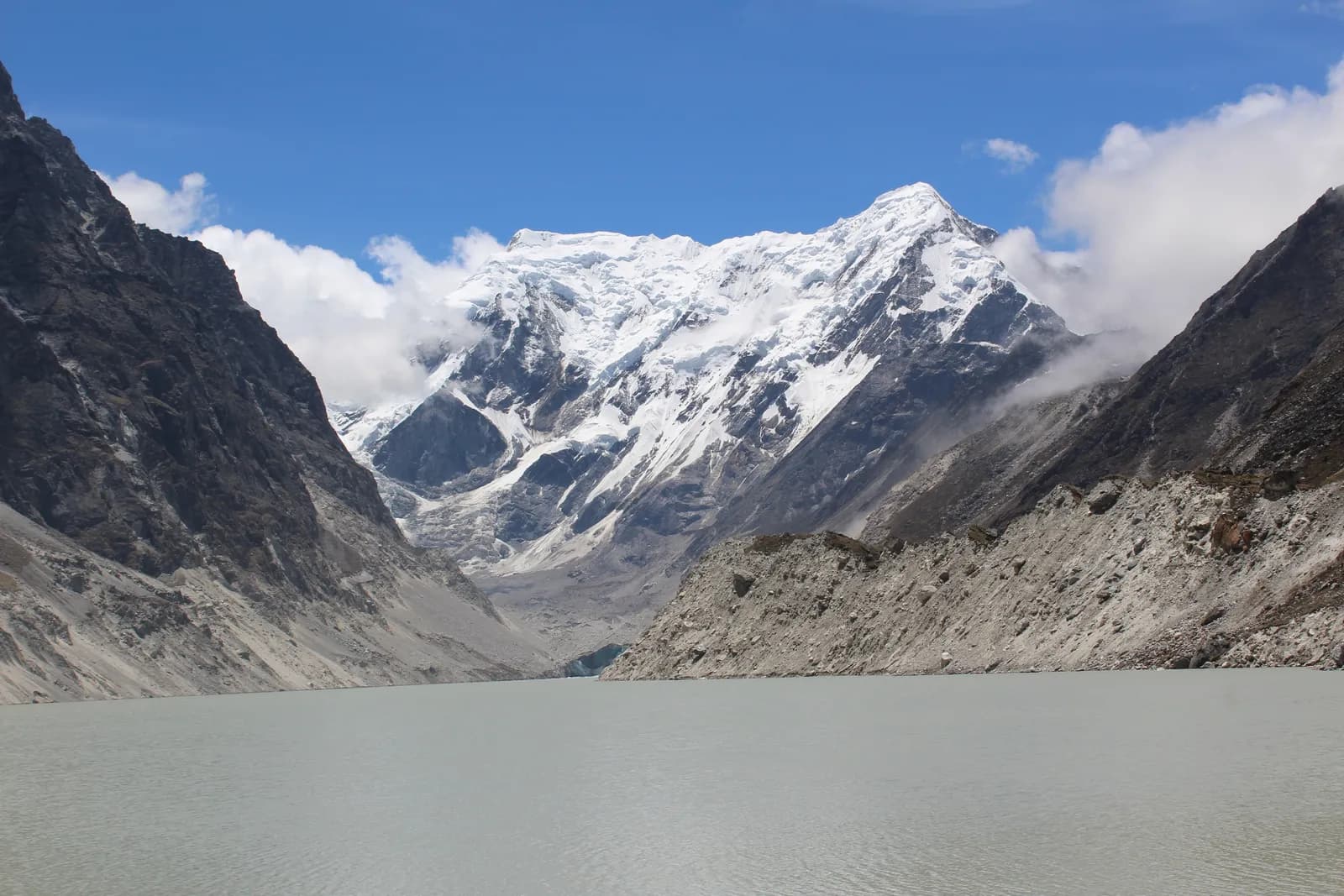
Rolwaling and Tsho Rolpa Trek
An 11-day road-access trek up the Rolwaling valley from Chetchet through Simigaon, Dongang, Beding and Na to Tsho Rolpa, a glacial lake at about 4,580 m under Gaurishankar.
- 일수11
- 최고 고도4,580 m
- 거리64.2 km
- 상승 고도3,847 m
- 난이도어려움
- 최적 시기Mar–May, Oct–Nov
- 퍼밋2
사진: Hrishav398 · CC BY-SA 4.0
영어로 표시됨 — 아직 번역되지 않았습니다.
이 일정은 초안이며 아직 확인되지 않았습니다. 구간은 항상 가이드와 확인하세요.
Written by FindTrekkingPartner team검토: FindTrekkingPartner team검토 방식FindTrekkingPartner
Rolwaling and Tsho Rolpa Trek은(는) 네팔 Rolwaling 지역의 11일 일정 트레킹으로, 최고 4,580 m까지 오릅니다. 외국인 트레커는 FindTrekkingPartner에 날짜, 예산, 페이스를 적어 트립을 올리면 이 트레킹의 파트너를 찾을 수 있습니다. 매칭은 두 트레커가 모두 동의하기 전까지 비공개로 유지되며, 서비스는 무료입니다. 중간 요금 기준으로 공인 가이드 비용은 트레커 4명이 함께할 때 11일 동안 1인당 약 USD 90, 혼자일 때는 USD 361입니다. 최적의 시즌은 Mar–May, Oct–Nov입니다. 이곳에서는 사실상 공인 가이드가 필요합니다. 2026년 운영업체들의 보고에 따르면 2023년 4월 네팔관광청 규정이 국립공원과 보전지역 검문소에서 시행되고 있으며, 랑탕이 가장 엄격하고 안나푸르나도 확인합니다(2026년 10월 19일 확인). 등록된 여행사를 통해 가이드를 고용하고 여행사에 확인하세요. 이 루트의 모집 중인 트립은 출발 월, 그룹 규모, 남은 자리와 함께 아래에 나와 있습니다. 최종 확인일: 2026년 10월 19일. 출처: 네팔관광청, DNPWC, 출입국관리국.
출처:Department of Immigration, NepalNepal Tourism BoardDepartment of National Parks and Wildlife Conservation
Rolwaling and Tsho Rolpa Trek 파트너 찾기
- Rolwaling and Tsho Rolpa Trek 파트너 찾기아직 모집 중인 트립이 없습니다
개요
출발지: Kathmandu11일 · 최고 4,580 m
최적 시즌: Mar–May, Oct–Nov · 퍼밋: Gaurishankar Conservation Area entry permit, TIMS card where required
The Rolwaling and Tsho Rolpa trek is an 11-day journey up a hidden Sherpa valley in Dolakha District, east of Langtang, to one of Nepal's largest glacial lakes at about 4,580 m. It drives from Kathmandu to Chetchet in a day, climbs to Simigaon, Dongang and Beding, rests at Beding, continues to Na for a day trip to Tsho Rolpa under the pyramid of Gaurishankar, 7,134 m, and returns by the same trail before the drive back. The route covers about 64 km on foot, with about 3,850 m of climbing, and sleeps up to about 4,190 m at Na. The valley lies in the Gaurishankar Conservation Area, so you need the conservation area permit and and a guide is strongly advised, but no restricted-area permit. The trek is hard because of steep trails and altitude, and the best months are October and November, and March to May. It suits fit trekkers who want a quiet valley close to Kathmandu.
What the trek is like
The trail starts above the Tamakoshi and Rolwaling rivers at Chetchet, then climbs steeply through terraces and forest to Simigaon, the first Sherpa village. From there it follows the Rolwaling Khola through rhododendron, oak and fir forest, crossing the river on bridges, to Dongang and then up to Beding, a village of stone houses and yak pastures on an open terrace. Above Beding the valley widens into meadows and moraine, and Na is a seasonal settlement at the foot of the lake trail. The lake itself sits behind a moraine dam, with the glacier and the peaks of the Rolwaling Himal behind it.
Highlights
- Tsho Rolpa, a glacial lake about 4,580 m high in the Rolwaling Valley
- Views of Gaurishankar, Menlungtse and the Rolwaling Himal from Beding and Na
- Simigaon and Beding, Sherpa villages with gompas and mani walls
- Rhododendron and fir forest, with chances of red panda and Himalayan tahr
- A trek that starts and ends with a road drive, with no flights
Permits and rules
You need a Gaurishankar Conservation Area entry permit, bought through your agency or at the checkpoint, and a TIMS card where the local office asks for it. Rolwaling is not a restricted area. The Nepal Tourism Board April 2023 rule requires foreign trekkers to use a licensed guide in national parks and conservation areas, and 2026 operator reports say checkpoints enforce it in Annapurna (ACAP), Langtang (the strictest) and most other parks, but not in Khumbu, where the municipality opted out (checked 19 October 2026). See the guide rule by region. Fees differ for foreigners, SAARC nationals and Nepalis, so ask for current amounts and check them with the National Trust for Nature Conservation or the Department of National Parks and Wildlife Conservation.
Best season
October and November are the best months, with stable weather and clear views. March to May bring rhododendron, though snow can linger above Beding early in spring. The monsoon has leeches, landslides and cloud, and December to February are very cold with snow above Dongang. Allow a spare day for the road.
Altitude
The plan climbs from Chetchet at about 1,410 m to Simigaon (about 1,970 m), Dongang (about 2,790 m) and Beding (about 3,710 m), then to Na (about 4,190 m), with a rest day at Beding and a day trip to the lake at about 4,580 m. The gain from Dongang to Beding is about 1,050 m in one day, so go slowly. Watch for headache, nausea and poor sleep, never ascend with symptoms, and descend if they worsen. Discuss altitude medicine with your doctor.
Getting there and away
Drive from Kathmandu via Charikot and Singati to Chetchet, about 8 to 9 hours in a jeep, with a rough last section. The road is prone to landslides in the monsoon, and in some years it ends at Singati, adding days. The return is the same drive on the last day. There are no flights, and a spare day for the road is wise.
Lodges, food and costs
Simple lodges and homestays operate at Chetchet, Simigaon, Dongang, Beding and Na, with dal bhat, noodles, potatoes and tea. Rooms are basic, with blankets, and during busy periods some groups camp at Na. Prices rise with altitude, and you should bring cash for the whole trek, because there are no machines beyond Charikot.
Packing list
Broken-in boots, waterproof layers, a down jacket, a sleeping bag rated to about minus 10 to minus 15 C, gloves, hat, sunglasses, sun cream, trekking poles, a headlamp, water purification and a first-aid kit. In the monsoon, add leech socks and a rain cover.
Who this trek suits and how to prepare
The trek suits fit trekkers who want a remote valley without flights. The climbs are steep, and the descent from Beding to Simigaon is a long day of about 19 km, so prepare with hill walks, stair training and some days with a loaded pack.
The plan at a glance
Day 1 drives to Chetchet. Days 2 to 4 walk to Simigaon, Dongang and Beding, with a rest day on day 5. Day 6 walks to Na and day 7 is the day trip to Tsho Rolpa. Days 8 to 10 return to Beding, Simigaon and Chetchet, and day 11 drives to Kathmandu.
Extensions
Add a day at Na for a walk toward Yalung Ri or a day in Simigaon for weather. Experienced trekkers with a specialist agency can cross the Tashi Lapcha, at about 5,755 m, to Thame in the Everest region, which needs technical equipment and the right permits. Others combine Rolwaling with the Everest region by road.
Practical tips from the trail
- Walking times in the day plan are estimates from distance and climb, checked against operator itineraries; real times differ with pace, load and weather.
- Go to the lake early, when the air is clear and the winds are light.
- Use poles on the long descent from Beding to Simigaon.
- Keep a warm layer and a waterproof jacket in your day bag.
- Do not camp on the dam, and follow your guide's advice near the lake.
- Book the return jeep in advance, since few vehicles wait at Chetchet.
Responsible trekking
Take rubbish out, do not swim or camp at the lake, walk clockwise around mani walls, buy from local lodges and ask before photographing people.
하이라이트
- Tsho Rolpa, one of the biggest glacial lakes in Nepal, at about 4,580 m
- Gaurishankar (7,134 m) and the Rolwaling Himal
- Sherpa villages at Simigaon, Beding and Na
- Rhododendron and fir forest in the Gaurishankar Conservation Area
- A quiet valley reached by road in a day
루트 지도
OpenStreetMap의 루트 데이터이며 아직 저희 팀이 확인하지 않았습니다. 계획용으로만 사용하고 길 안내용으로는 사용하지 마세요.
일별 일정
전날 밤보다 560 m 높은 곳에서 잡니다. 일반 권장 기준인 500 m를 넘습니다. 천천히 움직이고, 물을 충분히 마시고, 두통이나 메스꺼움을 살피세요.
A short walking day from Chetchet to Simigaon at about 1,970 m, about 2 km but with a steep climb of nearly 600 m, taking 2 to 3 hours. The path climbs through terraces, forest and stone steps to the first Sherpa village of the valley, with a gompa, mani walls and potato fields. Simigaon has simple lodges and good views up the valley. Use the afternoon to rest, drink water and prepare for tomorrow's longer day. The air is cool and the village is quiet.
전날 밤보다 820 m 높은 곳에서 잡니다. 일반 권장 기준인 500 m를 넘습니다. 천천히 움직이고, 물을 충분히 마시고, 두통이나 메스꺼움을 살피세요.
Walk from Simigaon to Dongang at about 2,790 m, about 9 km with a climb of 1,010 m, taking 4.5 to 6 hours. The trail follows the Rolwaling Khola through rhododendron, oak and fir forest, crossing the river on bridges and passing small waterfalls. Dongang is a forest clearing with a few lodges and the base for the climb to Beding. The air cools and views open. Rest, eat well and keep warm layers handy, because temperatures fall quickly in the evening.
전날 밤보다 920 m 높은 곳에서 잡니다. 일반 권장 기준인 500 m를 넘습니다. 천천히 움직이고, 물을 충분히 마시고, 두통이나 메스꺼움을 살피세요.
A steady climb from Dongang to Beding at about 3,710 m, about 10 km with a climb of 1,050 m, taking 5 to 6 hours. The valley opens as you leave the forest and enter meadows and moraine, with views of Gaurishankar and the Rolwaling Himal ahead. Beding is the main Sherpa village of the upper valley, with stone houses, a gompa, mani walls and yak herds. Settle in, watch for symptoms of altitude sickness and drink plenty of water. Tomorrow is a rest day.
A rest and acclimatisation day at Beding. Visit the gompa, walk around the village and take an easy hike up the meadows above the houses for views of Gaurishankar and the valley, returning by the afternoon. The aim is to sleep at the same height as the day before, and to let your body adapt. Drink water, eat well and talk to your guide about the route and weather. Use the afternoon to dry gear and charge power banks if the lodge has solar power.
Walk from Beding to Na at about 4,190 m, about 6 km with a climb of 490 m, taking 2.5 to 3.5 hours. The trail follows the valley through meadows and moraine, with views of Gaurishankar and the glacier basin. Na is a seasonal settlement of a few lodges and yak huts, used by herders in summer. It is cold and windy, so put on your warm layers early. Rest, drink water and watch for symptoms of altitude sickness. Tomorrow is the lake.
A day trip from Na to Tsho Rolpa at about 4,580 m and back, about 9 km with 380 m of climbing, taking 6 to 8 hours. The trail climbs on moraine to the lake, a glacial lake held by a moraine dam under the Trakarding glacier, with views of Gaurishankar and the Rolwaling Himal. Start early, carry food and water, and follow your guide's advice near the lake edge. Do not camp on the dam or swim in the lake. Return to Na for the night.
Descend from Na to Beding at about 3,710 m, about 6 km with a descent of 470 m, taking 1.5 to 2.5 hours. The trail retraces the meadows and moraine, with views of Gaurishankar and the valley behind you. The thicker air feels welcome, and your appetite should improve. Beding's lodges offer hot meals and a warm room. Use the afternoon to rest, wash and dry gear. Tomorrow is a long descent, so prepare your legs. Keep a warm layer on, since the afternoon cools quickly at this height.
A long descent from Beding to Simigaon at about 1,970 m, about 19 km with 2,030 m of descent and 310 m of climbing, taking 5.5 to 8 hours. The trail follows the Rolwaling Khola through Dongang, crossing bridges and forest, and ends with a steep drop to the Sherpa village. Use poles and take short breaks, because the knees take a pounding. The air warms as you descend, and leeches can appear in wet weather. Simigaon's lodges are simple but welcoming.
A short walk from Simigaon down to Chetchet at about 1,410 m, about 2 km with a drop of 600 m, taking 1 to 1.5 hours. The steep path follows the same route as the first day, and the knees may complain. Your jeep waits at the roadhead, or you rest in a lodge and drive in the morning. Use the time to thank your crew, wash and repack. The warm air and the sounds of the valley make the last evening pleasant.
Drive from Chetchet back to Kathmandu, about 8 to 9 hours via Singati and Charikot. The road is rough at first and gets better as you reach the highway. Leave early to arrive in Kathmandu in the afternoon, and keep a spare day in the schedule in case landslides block the road. Back in the hotel, shower, repack and celebrate with a good dinner. Tip your guide and porters according to your agency's guidelines. Keep your passport and permit copies in your hand luggage.
고소 적응
밤마다의 숙박 고도입니다. 빨간 막대는 전날 밤보다 500 m 넘게 올라가는 날이며, 휴식일은 표시됩니다.
- 숙박 고도
- 500 m 초과 상승
- 휴식일
비용
1인당 예상 총비용: 고도별 롯지와 식사, 교통, 퍼밋, 가이드와 포터. 가이드와 포터를 나누는 트레커가 많을수록 1인당 부담이 줄어듭니다. 2026년 10월 기준.
| 스타일 | 트레커 1명 분담 | 트레커 2명 분담 | 트레커 4명 분담 |
|---|---|---|---|
| 저예산 | US$550–US$850* | US$410–US$630* | US$340–US$520* |
| 중간 | US$770–US$1,200* | US$560–US$860* | US$490–US$750* |
| 편안함 | US$870–US$1,350* | US$730–US$1,100* | US$660–US$990* |
가이드를 나누고 비용 절약
중간형 기준으로 혼자 트레킹하면 약 US$770–US$1,200, 트레커 4명이 가이드 1명과 포터 2명을 나누면 1인당 약 US$490–US$750입니다 (범위 상단 기준 38% 절감).
2명 분담 시 내역
| 항목 | 저예산 | 중간 | 편안함 |
|---|---|---|---|
| 롯지 및 식사 | US$210–US$350 | US$290–US$460 | US$390–US$600 |
| 퍼밋 | US$50–US$60 | US$50–US$60 | US$50–US$60 |
| 가이드 | US$130–US$230 | US$130–US$230 | US$130–US$230 |
| 포터 | — | US$70–US$120 | US$140–US$230 |
예산형은 대중교통을 이용하고 포터가 없습니다. 중간형은 트레커 두 명이 포터 한 명을 나누고 전용 차량을 씁니다. 편안형은 트레커마다 포터가 한 명씩 있습니다. 가이드는 필수이거나 스타일이 중간형 또는 편안형인 경우에 포함됩니다.
1박 롯지 및 식사 (객실과 달밧 식사)
4박 Below 2,500 m: 객실 US$2–US$9, 달밧 US$4–US$7 · 4박 2,500 to 3,800 m: 객실 US$4–US$11, 달밧 US$5–US$11 · 2박 Above 3,800 m: 객실 US$7–US$19, 달밧 US$8–US$13
퍼밋 요금 (공식 출처)
포함되지 않음
공개된 가격을 찾지 못한 항목: Kathmandu to Chetchet jeep, out and back. *로 표시된 총액에는 이 항목이 빠져 있으니 에이전시에 문의하세요.
비용 출처
- PriceNepal: Nepal Travel Cost Guide 2026 (2026-05-14)
- Third Rock Adventures: Nepal trek budget planner (2026-05-09)
- Himalayan Partner: Guide and porter price in Nepal 2026 (2026-02-10)
- Shikhar Adventure: Annapurna Circuit trek cost (2026-02-03)
- Nepal Tourism Board: Trekking Permit (2026-10-18)
운영사 가이드를 바탕으로 한 추정치이며 견적이 아닙니다. 팁, 보험, 장비, 카트만두 호텔은 포함되지 않으며 USD는 플랫폼 환율을 적용했습니다.
사진
자주 묻는 질문
You need the Gaurishankar Conservation Area entry permit. Rolwaling is not a restricted area, and no Restricted Area Permit is required for Tsho Rolpa.
The Nepal Tourism Board April 2023 rule requires foreign trekkers to use a licensed guide in national parks and conservation areas, and 2026 operator reports say checkpoints enforce it in Annapurna (ACAP), Langtang (the strictest) and most other parks, but not in Khumbu, where the municipality opted out (checked 19 October 2026). Confirm with a registered agency. Lodges are few and the trails are steep, so a guide is advised.
Eleven days from Kathmandu on this plan, including two driving days, six walking days, a rest day at Beding and the lake day trip from Na. Allow a spare day for the road.
About 4,580 m. Na, where you sleep, is at about 4,190 m.
It is a glacial lake with an outburst flood risk for villages downstream, and an early warning system was installed in the late 1990s. Trekkers visit the shore safely with a guide but should not camp on the dam.
October and November, and March to May. The monsoon has leeches and landslides, and winter closes the upper valley.
Drive from Kathmandu via Charikot and Singati in 8 to 9 hours. The road can be blocked by landslides, and there is no flight.
출처
- Tsho Rolpa Lake Trek, 10 days (Trekking in Nepal)
- Rolwaling Valley Trek (Himalaya Trip)
- Rolwaling Himal (Wikipedia)
- Tsho Rolpa (Wikipedia)
- Gaurishankar Conservation Area (Wikipedia)
- National Trust for Nature Conservation
- Department of National Parks and Wildlife Conservation, Nepal
- Nepal Tourism Board
- OpenStreetMap (elevation tags of villages and lakes)
트레일 주변
루트의 매일마다 있는 숙소, 의료 지원, 식수, 볼거리입니다.
1. Kathmandu → Chetchet
- Tribhuvan International Airport · 공항 및 교통 · 1,340 m
2. Chetchet → Simigaon
이 날에 지도에 표시된 항목이 아직 없습니다.이 날에 지도에 표시된 항목이 아직 없습니다.3. Simigaon → Dongang
- Bedrock · 자연 · 2,825 m
4. Dongang → Beding
이 날에 지도에 표시된 항목이 아직 없습니다.이 날에 지도에 표시된 항목이 아직 없습니다.5. Beding
이 날에 지도에 표시된 항목이 아직 없습니다.이 날에 지도에 표시된 항목이 아직 없습니다.6. Beding → Na
- Maelungtse View Lodge · 숙소 · 3,728 m
- Josef Phurba Lodge · 숙소 · 4,187 m
7. Na
- Na-View Point Hotel Camp Site · 숙소 · 4,185 m
- Na-View Point Hotel · 숙소 · 4,187 m
- Viewpoint · 전망대 · 4,554 m
- Tsho Rolpa Lake · 자연 · 4,552 m
8. Na → Beding
이 날에 지도에 표시된 항목이 아직 없습니다.이 날에 지도에 표시된 항목이 아직 없습니다.9. Beding → Simigaon
- Surmuche Hotel · 숙소 · 2,513 m
- Gaurishankar hotel · 숙소 · 2,010 m
- Sumigaun · 숙소 · 2,009 m
10. Simigaon → Chetchet
이 날에 지도에 표시된 항목이 아직 없습니다.이 날에 지도에 표시된 항목이 아직 없습니다.11. Chetchet → Kathmandu
이 날에 지도에 표시된 항목이 아직 없습니다.이 날에 지도에 표시된 항목이 아직 없습니다.
2026. 10. 19. 최종 확인오래된 정보 신고