

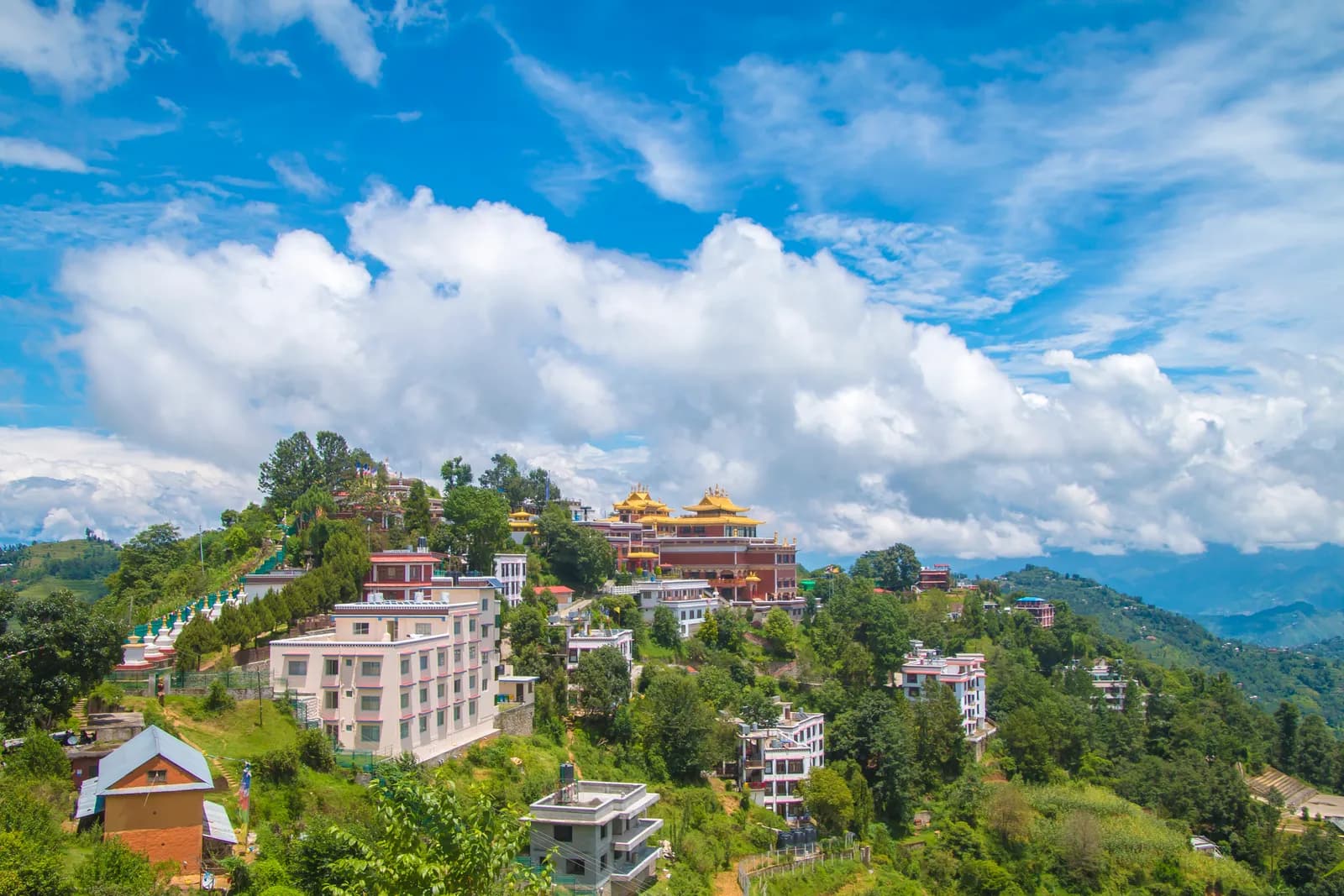
Travel from Kathmandu to Dhulikhel by taxi or bus and start walking early. The trail leaves town through villages, terraced fields and patches of forest and climbs gently to Namo Buddha, about two and a half hours on, where the golden roofs of Thrangu Tashi Yangtse monastery stand above the stupa. Have lunch there and visit the monastery. Then walk downhill towards Panauti, another two and a half hours by the guide's account, passing farms and small villages, and finish in the old Newar town. On our map the day is 19.4 km with 610 m of climbing and 720 m of descent, mostly on quiet roads and tracks. Take a taxi from Panauti back to Kathmandu.
Namo Buddha Day Hike
A one-day walk from Dhulikhel through terraced farmland and forest to the Namo Buddha monastery hill (about 1,750 m) and down to the Newar town of Panauti, 19.4 km on our map.
- Hari1
- Ketinggian maks.1.750 m
- Jarak18,8 km
- Pendakian547 m
- KesulitanMudah
- Bulan terbaikMar–May, Sep–Nov
Rencanakan trip dengan rencana perjalanan iniCari partner untuk Namo Buddha Day HikeLihat keberangkatan per minggu
Foto: Rukeshmdr12 · CC BY-SA 4.0
Ditampilkan dalam bahasa Inggris — belum diterjemahkan.
Rencana perjalanan ini masih draf dan belum diverifikasi. Selalu konfirmasikan tahapannya dengan pemandu Anda.
Written by FindTrekkingPartner teamDitinjau oleh FindTrekkingPartner teamCara kami meninjauFindTrekkingPartner
Namo Buddha Day Hike adalah trek 1 hari di wilayah Kathmandu Valley, Nepal, yang mendaki hingga 1.750 m. Trekker asing dapat mencari teman untuk trek ini di FindTrekkingPartner dengan memposting trip berisi tanggal, anggaran, dan kecepatan mereka. Kecocokan tetap privat sampai kedua trekker setuju, dan layanannya gratis. Pada tarif menengah, pemandu berlisensi memerlukan sekitar USD 9 per orang selama 1 hari jika empat trekker berbagi, dibandingkan USD 37 untuk satu trekker sendirian. Musim terbaik adalah Oct–Nov, Mar–Apr. Pemandu berlisensi tidak diwajibkan di rute terbuka seperti ini (dicek 19 Oktober 2026): kotamadya Khumbu keluar dari aturan Nepal Tourism Board April 2023 dan hiking harian tidak memerlukannya, tetapi pemandu tetap sangat disarankan, jadi konfirmasikan dengan agen Anda. Trip terbuka untuk rute ini tercantum di bawah, lengkap dengan bulan berangkat, ukuran grup, dan sisa tempat. Terakhir diverifikasi: 19 Oktober 2026. Sumber: Nepal Tourism Board, DNPWC, Department of Immigration.
Sumber:Department of Immigration, NepalNepal Tourism BoardDepartment of National Parks and Wildlife Conservation
Cari teman untuk Namo Buddha Day Hike
- Cari teman untuk Namo Buddha Day HikeBelum ada trip terbuka
- Cari teman untuk Shivapuri Peak Day HikeBelum ada trip terbuka
- Cari teman untuk Nagarkot to Changu Narayan Day HikeBelum ada trip terbuka
- Cari teman untuk Chisapani Nagarkot TrekBelum ada trip terbuka
- Cari teman untuk Champadevi Day HikeBelum ada trip terbuka
- Cari teman untuk Phulchowki Day HikeBelum ada trip terbuka
Ikhtisar
Mulai dari Dhulikhel1 hari · maks. 1.750 m
Musim terbaik: Mar–May, Sep–Nov
The Namo Buddha hike is a one-day walk from Dhulikhel, on the eastern rim of the Kathmandu Valley, through terraced farmland and forest to the Namo Buddha monastery hill, then downhill to the old Newar town of Panauti. On our map the walk is about 19.4 km with 610 m of climbing and 720 m of descent, partly on quiet roads. Operators allow five to six hours including rests, and one guide gives about two and a half hours from Dhulikhel to Namo Buddha and another two and a half to Panauti, a total of 14 to 16 km. We say allow six to seven hours, because our mapped route is longer. The highest point is about 1,750 m. A taxi from Kathmandu to Dhulikhel takes about an hour. None of our sources lists a permit.
The plan follows an operator itinerary and a day-trip guide that agree on the order, Dhulikhel to Namo Buddha to Panauti, and on the lunch stop at the monastery hill. Our map follows roads and tracks because OpenStreetMap has few footpaths here, so it is longer than the guide's 14 to 16 km.
What the hike is like
The trail leaves Dhulikhel through villages and terraced fields, with patches of forest, and climbs gently to Namo Buddha, where Thrangu Tashi Yangtse monastery stands with golden roofs above a stupa. According to Wikipedia, the site recalls a past life of the Buddha who gave his body to save a tigress and her cubs. A stairway through the woods links the stupa to the legend site. After lunch the way drops towards Panauti, an ancient Newari town.
Permits and rules
None of our sources lists a permit or park fee. Monuments and monasteries may charge small entrance fees; operator pages include them in their price without giving amounts. Remove shoes before entering temples and dress modestly.
Best season
Spring (March to May) and autumn (September to November) are the most popular, according to an operator, and winter and monsoon walks are possible.
Getting there and away
Dhulikhel is about an hour by taxi from Kathmandu, or an operator transfer of about 1.5 hours. Local buses run from Ratna Park to Dhulikhel. From Panauti local buses also run from Ratna Park with changes involved, and a taxi is simpler.
Difficulty and fitness
The walk is easy to moderate: 610 m of climbing spread over most of a day. Carry water and a packed lunch, and start by 8 am to reach Panauti before dark.
Budget notes
There is no permit fee. Pay for a taxi or bus to Dhulikhel and a taxi from Panauti, plus lunch. The costs section shows the taxis as lines to check.
Sorotan
- Namo Buddha, a Buddhist pilgrimage site above terraced fields
- Thrangu Tashi Yangtse monastery with its golden roofs
- Terraces, villages and forest between Dhulikhel and Panauti
- Panauti, an old Newar town at the end of the walk
- Mostly gentle going with little altitude gain
Peta rute
Data rute dari OpenStreetMap, belum diperiksa tim kami. Gunakan untuk perencanaan, bukan navigasi.
Hari demi hari
Biayanya
Perkiraan biaya total per orang: lodge dan makanan menurut ketinggian, transportasi, izin, serta pemandu dan porter. Semakin banyak trekker berbagi pemandu dan porter, semakin sedikit yang dibayar tiap orang. Per Oktober 2026.
| Gaya | 1 trekker berbagi | 2 trekker berbagi | 4 trekker berbagi |
|---|---|---|---|
| Hemat | — | — | — |
| Menengah | US$40–US$80* | US$20–US$40* | US$10–US$30* |
| Nyaman | US$40–US$80* | US$30–US$50* | US$20–US$40* |
Bagi pemandu, hemat uang
Pada kisaran menengah, trekker solo membayar sekitar US$40–US$80; empat trekker berbagi satu pemandu dan dua porter membayar sekitar US$10–US$30 per orang (66% lebih murah di ujung atas kisaran).
Rincian untuk 2 trekker berbagi
| Item | Hemat | Menengah | Nyaman |
|---|---|---|---|
| Pemandu | — | US$10–US$30 | US$10–US$30 |
| Porter | — | US$0–US$20 | US$10–US$30 |
Hemat memakai transportasi umum dan tanpa porter; menengah berbagi satu porter untuk dua trekker dan kendaraan pribadi; nyaman memberi setiap trekker seorang porter. Pemandu disertakan jika diwajibkan atau gayanya menengah atau nyaman.
Tidak termasuk
Tidak ditemukan harga yang dipublikasikan untuk: Kathmandu to Dhulikhel by taxi; Panauti to Kathmandu by taxi. Total bertanda * tidak menyertakannya; tanyakan ke agen Anda. A day hike: no lodging and no permit. A guide is optional.
Sumber biaya
- PriceNepal: Nepal Travel Cost Guide 2026 (2026-05-14)
- Third Rock Adventures: Nepal trek budget planner (2026-05-09)
- Himalayan Partner: Guide and porter price in Nepal 2026 (2026-02-10)
- Shikhar Adventure: Annapurna Circuit trek cost (2026-02-03)
- Nepal Tourism Board: Trekking Permit (2026-10-18)
Perkiraan dari panduan operator, bukan penawaran harga. Tip, asuransi, perlengkapan, dan hotel di Kathmandu tidak termasuk; USD dengan kurs platform.
Foto
Pertanyaan yang sering diajukan
Operators allow five to six hours including rests. One guide gives about 2.5 hours from Dhulikhel to Namo Buddha and another 2.5 to Panauti, 14 to 16 km. Our mapped route is 19.4 km, so allow six to seven hours.
An operator gives a maximum height of about 1,750 m for the hike.
None of our sources lists a permit or park fee. Operator prices include small monument entrance fees without naming amounts.
Our plan and the operator itinerary go from Dhulikhel to Namo Buddha for lunch and then downhill to Panauti, which keeps the climbing gentle.
Take a taxi from Panauti, about an hour, which a day-trip guide calls simpler than local buses that involve changes.
Sumber
Di sepanjang jalur
Penginapan, bantuan medis, air, dan pemandangan di setiap hari rute.
1. Dhulikhel → Panauti
- Dhulikhel Hospital · Medis · 1.523 m
- Dhulikhel Clinic Center · Medis · 1.501 m
- Pond · Praktis · 1.549 m
- Water Tank · Praktis · 1.658 m
- Bhimsensthan Viewpoint · Titik pandang · 1.546 m
- V-sign Guest House · Penginapan · 1.449 m
- Maneshwori Mo:Mo · Penginapan · 1.447 m
- Namaste Samudai Home Stay · Penginapan · 1.450 m
Show all 53 places
- R.K Pharmacy · Medis · 1.525 m
- Achutan Pharmacy · Medis · 1.524 m
- Balaram Pharmacy · Medis · 1.525 m
- Dhulikhel Hospital · Medis · 1.523 m
- Dhulikhel Clinic Center · Medis · 1.501 m
- Ku Helipad · Bandara & transportasi · 1.470 m
- Pediatrics and Gyn/Obs · Medis · 1.510 m
- Pond · Praktis · 1.549 m
- Love Bird · Penginapan · 1.550 m
- Dada Pari Lama Hotel · Penginapan · 1.555 m
- Sanu Khaja Ghar · Penginapan · 1.556 m
- Star Momo · Penginapan · 1.556 m
- Sanjibani Newari Khaja Ghar · Penginapan · 1.558 m
- Timal Hotel · Penginapan · 1.558 m
- Bishal Hotel · Penginapan · 1.558 m
- Mama ko hotel · Penginapan · 1.558 m
- Roshi bhojanalaye · Penginapan · 1.557 m
- Sanjibani · Penginapan · 1.559 m
- Krishna bhojanayala · Penginapan · 1.559 m
- Water Tank · Praktis · 1.658 m
- Drinking Water · Praktis · 1.536 m
- Bhimsensthan Viewpoint · Titik pandang · 1.546 m
- Hotel Green Peace Lodge And Resort · Penginapan · 1.547 m
- Pancha tamang hotel · Penginapan · 1.703 m
- Aahana Pharmacy · Medis · 1.667 m
- Ram Gopal Baidya Medical Centre · Medis · 1.640 m
- Sornim Phamacy · Medis · 1.640 m
- Kulung hotel · Penginapan · 1.704 m
- Namobuddha Hotel And Lodge · Penginapan · 1.707 m
- Thrangu Phende Clinic · Medis · 1.721 m
- Stupa view point · Titik pandang · 1.760 m
- Viewpoint · Titik pandang · 1.757 m
- Namobuddha Motel · Penginapan · 1.672 m
- Sankhu Homestay · Penginapan · 1.514 m
- Pariwar Syasthya Clinic · Medis · 1.454 m
- Prathamik Swasthya Kendra, Sunthan · Medis · 1.499 m
- Panauti Hospital · Medis · 1.453 m
- Rebika Pharmacy · Medis · 1.454 m
- Krishnamohan Pharmacy · Medis · 1.454 m
- Samudayik ATM · Praktis · 1.450 m
- V-sign Guest House · Penginapan · 1.449 m
- Machhe Pharmacy · Medis · 1.449 m
- Maneshwori Mo:Mo · Penginapan · 1.447 m
- Bhairab Hospital · Medis · 1.450 m
- Prakash Drug House · Medis · 1.447 m
- Karmacharya Pharma · Medis · 1.450 m
- SomSarobar Medical Hall · Medis · 1.447 m
- Rehab Center · Medis · 1.471 m
- Red Cross · Medis · 1.457 m
- Panauti Public Health Post · Medis · 1.452 m
- Namaste Samudai Home Stay · Penginapan · 1.450 m
- Tap (Dhunge Dharo) · Praktis · 1.452 m
- Gita devi ozone mart · Medis · 1.444 m