

Drive from Kathmandu to Nagarkot, about 1.5 hours, ideally for sunrise, and have tea before you start. The trail leaves the ridge and descends through pine and rhododendron forest and terraced fields, passing Tamang and Newar villages. About two and a half hours on, you reach Telkot, the midway rest stop, where you can visit a small monastery. The way continues downhill with a few gentle ascents to Changu Narayan, a hilltop temple on the UNESCO World Heritage list, where lunch and sightseeing end the day. On our map it is 11.7 km with 150 m of climbing and 535 m of descent, mostly on village roads and tracks. A vehicle back to Kathmandu takes about an hour.
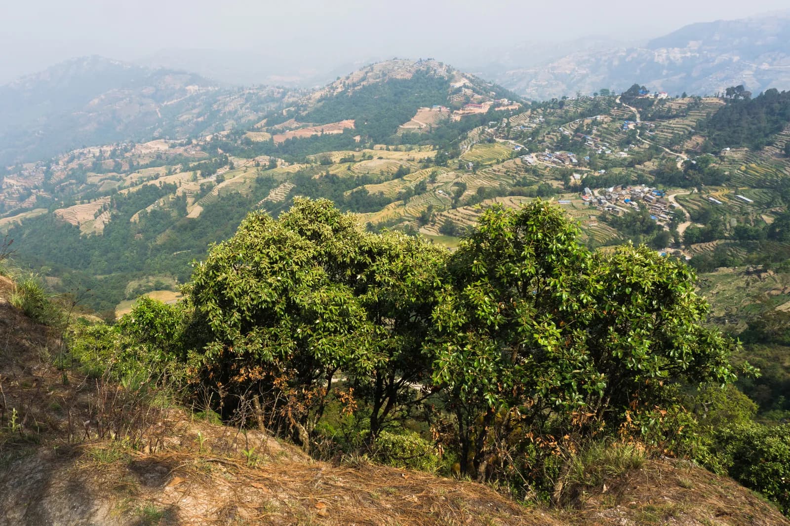
Nagarkot to Changu Narayan Day Hike
A one-day downhill walk from the ridge village of Nagarkot through Telkot and Newar and Tamang villages to Changu Narayan temple, 11.7 km on our map, mostly downhill.
- Hari1
- Ketinggian maks.2.175 m
- Jarak11,7 km
- Pendakian149 m
- KesulitanMudah
- Bulan terbaikMar–May, Oct–Nov
Rencanakan trip dengan rencana perjalanan iniCari partner untuk Nagarkot to Changu Narayan Day HikeLihat keberangkatan per minggu
Foto: Alexey Komarov · CC BY-SA 4.0
Ditampilkan dalam bahasa Inggris — belum diterjemahkan.
Rencana perjalanan ini masih draf dan belum diverifikasi. Selalu konfirmasikan tahapannya dengan pemandu Anda.
Written by FindTrekkingPartner teamDitinjau oleh FindTrekkingPartner teamCara kami meninjauFindTrekkingPartner
Nagarkot to Changu Narayan Day Hike adalah trek 1 hari di wilayah Kathmandu Valley, Nepal, yang mendaki hingga 2.175 m. Trekker asing dapat mencari teman untuk trek ini di FindTrekkingPartner dengan memposting trip berisi tanggal, anggaran, dan kecepatan mereka. Kecocokan tetap privat sampai kedua trekker setuju, dan layanannya gratis. Pada tarif menengah, pemandu berlisensi memerlukan sekitar USD 9 per orang selama 1 hari jika empat trekker berbagi, dibandingkan USD 37 untuk satu trekker sendirian. Musim terbaik adalah Oct–Nov, Mar–Apr. Pemandu berlisensi tidak diwajibkan di rute terbuka seperti ini (dicek 19 Oktober 2026): kotamadya Khumbu keluar dari aturan Nepal Tourism Board April 2023 dan hiking harian tidak memerlukannya, tetapi pemandu tetap sangat disarankan, jadi konfirmasikan dengan agen Anda. Trip terbuka untuk rute ini tercantum di bawah, lengkap dengan bulan berangkat, ukuran grup, dan sisa tempat. Terakhir diverifikasi: 19 Oktober 2026. Sumber: Nepal Tourism Board, DNPWC, Department of Immigration.
Sumber:Department of Immigration, NepalNepal Tourism BoardDepartment of National Parks and Wildlife Conservation
Cari teman untuk Nagarkot to Changu Narayan Day Hike
- Cari teman untuk Nagarkot to Changu Narayan Day HikeBelum ada trip terbuka
- Cari teman untuk Shivapuri Peak Day HikeBelum ada trip terbuka
- Cari teman untuk Chisapani Nagarkot TrekBelum ada trip terbuka
- Cari teman untuk Champadevi Day HikeBelum ada trip terbuka
- Cari teman untuk Phulchowki Day HikeBelum ada trip terbuka
- Cari teman untuk Namo Buddha Day HikeBelum ada trip terbuka
Ikhtisar
Mulai dari Nagarkot1 hari · maks. 2.175 m
Musim terbaik: Mar–May, Oct–Nov
The Nagarkot to Changu Narayan hike is a one-day downhill walk from the ridge village of Nagarkot, about 2,150 m, through Telkot and a string of Tamang and Newar villages to the temple hill of Changu Narayan. On our map the walk is about 11.7 km with 150 m of climbing and 535 m of descent, on village roads, tracks and forest paths. Operators give about 14 km and four to five hours, with a rest stop at Telkot, so our shorter map line looks a little brisk. You drive about 1.5 hours from Kathmandu to Nagarkot, ideally in time for the sunrise view, and take about an hour back from Changu Narayan, or a short bus ride to Bhaktapur. The Nagarkot viewpoint and the Changu Narayan temple charge entrance fees. Carry water and lunch.
The plan follows two operator itineraries that agree on Nagarkot, Telkot and the temple, and on the timing of about four and a half hours with a break. Heights differ: sources give Nagarkot at 2,100 to 2,195 m, and Wikivoyage gives 2,163 m. The same descent is the last day of our Chisapani Nagarkot trek.
What the hike is like
The trail leaves Nagarkot's ridge and descends through pine and rhododendron forest and terraced fields, passing small Tamang and Newar villages. Telkot is the midway rest stop, with an optional monastery visit. The path is wide and easy as long as you wear hiking shoes, with a few gentle ascents. Changu Narayan sits on a hilltop. According to Wikipedia it was listed as a UNESCO World Heritage Site in 1979 and stands about 12 km east of Kathmandu, and a pillar there dates to 464 AD.
Permits and rules
None of our sources lists a park permit for this route. Two entrance fees apply: the Nagarkot viewpoint and the Changu Narayan temple, which operators include in their prices without giving amounts. Dress modestly at the temple and keep to the marked path.
Best season
October to November and March to May, according to operators, who also say it can be walked all year. Autumn and spring have the clearest mountain views; Nagarkot sunrise views are best before cloud builds.
Getting there and away
A taxi from Kathmandu to Nagarkot costs NPR 2,000 to 3,000 one way and takes 1.5 to 2 hours, according to Wikivoyage. Public buses via Bhaktapur cost under NPR 100 and take about two hours. From Changu Narayan a private vehicle takes about one hour to Kathmandu, or a short bus ride reaches Bhaktapur.
Difficulty and fitness
The route is easy: it descends 535 m over 11.7 km, on wide paths and quiet roads. Wear shoes with grip, carry two litres of water, and start by 9 am.
Budget notes
The main cost is the taxi to Nagarkot, NPR 2,000 to 3,000 one way, plus the two entrance fees and lunch. The return from Changu Narayan is shown as a line to check.
Sorotan
- Nagarkot at about 2,150 m, a classic Himalayan viewpoint
- Telkot, the midway rest stop, with an optional monastery visit
- Pine and rhododendron forest, terraced fields and Tamang and Newar villages
- Changu Narayan, a hilltop temple and UNESCO World Heritage Site
- Mostly downhill, so easy on the legs
Peta rute
Data rute dari OpenStreetMap, belum diperiksa tim kami. Gunakan untuk perencanaan, bukan navigasi.
Hari demi hari
Biayanya
Perkiraan biaya total per orang: lodge dan makanan menurut ketinggian, transportasi, izin, serta pemandu dan porter. Semakin banyak trekker berbagi pemandu dan porter, semakin sedikit yang dibayar tiap orang. Per Oktober 2026.
| Gaya | 1 trekker berbagi | 2 trekker berbagi | 4 trekker berbagi |
|---|---|---|---|
| Hemat | US$10–US$30* | US$0–US$20* | US$0–US$10* |
| Menengah | US$60–US$100* | US$30–US$50* | US$10–US$30* |
| Nyaman | US$60–US$100* | US$30–US$60* | US$20–US$50* |
Bagi pemandu, hemat uang
Pada kisaran menengah, trekker solo membayar sekitar US$60–US$100; empat trekker berbagi satu pemandu dan dua porter membayar sekitar US$10–US$30 per orang (68% lebih murah di ujung atas kisaran).
Rincian untuk 2 trekker berbagi
| Item | Hemat | Menengah | Nyaman |
|---|---|---|---|
| Transportasi | US$0–US$20 | US$0–US$20 | US$0–US$20 |
| Pemandu | — | US$10–US$30 | US$10–US$30 |
| Porter | — | US$0–US$20 | US$10–US$30 |
Hemat memakai transportasi umum dan tanpa porter; menengah berbagi satu porter untuk dua trekker dan kendaraan pribadi; nyaman memberi setiap trekker seorang porter. Pemandu disertakan jika diwajibkan atau gayanya menengah atau nyaman.
Tidak termasuk
Tidak ditemukan harga yang dipublikasikan untuk: Changu Narayan to Kathmandu by taxi. Total bertanda * tidak menyertakannya; tanyakan ke agen Anda. A day hike: no lodging and no permit; viewpoint and temple entrance fees apply but no amounts are published in our sources.
Sumber biaya
- PriceNepal: Nepal Travel Cost Guide 2026 (2026-05-14)
- Third Rock Adventures: Nepal trek budget planner (2026-05-09)
- Himalayan Partner: Guide and porter price in Nepal 2026 (2026-02-10)
- Shikhar Adventure: Annapurna Circuit trek cost (2026-02-03)
- Nepal Tourism Board: Trekking Permit (2026-10-18)
Perkiraan dari panduan operator, bukan penawaran harga. Tip, asuransi, perlengkapan, dan hotel di Kathmandu tidak termasuk; USD dengan kurs platform.
Foto
Pertanyaan yang sering diajukan
Operators give four to five hours and about 14 km. Our map shows 11.7 km with 150 m of climbing and 535 m of descent.
Mostly. Operators describe it as relatively easy downhill with a few gentle ascents, from about 2,150 m at Nagarkot down to the temple hill.
Wikivoyage gives NPR 2,000 to 3,000 one way, taking 1.5 to 2 hours. Public buses via Bhaktapur cost under NPR 100 and take about two hours.
None of our sources lists a park permit. The Nagarkot viewpoint and Changu Narayan temple charge entrance fees; operators include them without giving the amounts.
Yes. Operators drive from Kathmandu about 1.5 hours to Nagarkot for tea and the view before starting the walk.
Sumber
Di sepanjang jalur
Penginapan, bantuan medis, air, dan pemandangan di setiap hari rute.
1. Nagarkot → Changu Narayan
- Club Himalaya · Penginapan · 1.924 m
- Viewpoint · Titik pandang · 1.662 m
- Narayan Hiti · Praktis · 1.467 m
- Chayanath health care · Medis · 1.334 m
- Infirmary · Medis · 1.335 m
- The Nest Guest Gouse · Penginapan · 1.509 m
- Drinking Water · Praktis · 1.538 m
- Gam Dhoka Park · Titik pandang · 1.507 m
Show all 25 places
- Club Himalaya · Penginapan · 1.924 m
- Himalayan guest house · Penginapan · 1.910 m
- Hotel Nagarkot Peak · Penginapan · 1.904 m
- Hotel Nagarkot Holiday Inn · Penginapan · 1.907 m
- Hotel Himalayan heart · Penginapan · 1.904 m
- Hotel Himalyan heart · Penginapan · 1.903 m
- Hotel Sakura Durbar · Penginapan · 1.903 m
- Nagarkot Food Home · Penginapan · 1.910 m
- Langtang View Nagarkot Bed & Breakfast · Penginapan · 1.917 m
- Hotel Panaroma Inn Restaurant & Bar · Penginapan · 1.906 m
- Panaroma inn · Penginapan · 1.905 m
- Silver Mountain · Penginapan · 1.903 m
- Gaurisankhar · Penginapan · 1.904 m
- Sister’s homestay · Penginapan · 1.780 m
- Hotel Sunrise · Penginapan · 1.790 m
- Viewpoint · Titik pandang · 1.662 m
- Nagarkot Waterfall · Alam · 1.513 m
- Hotel Rudrakshya · Penginapan · 1.632 m
- Muskan Pharma · Medis · 1.371 m
- Narayan Hiti · Praktis · 1.467 m
- Drinking Water · Praktis · 1.538 m
- Gam Dhoka Park · Titik pandang · 1.507 m
- Chayanath health care · Medis · 1.334 m
- Infirmary · Medis · 1.335 m
- The Nest Guest Gouse · Penginapan · 1.509 m