

Fly from Kathmandu to Bhadrapur, an hour east in the Terai plains at about 100 m. The flight crosses the foothills and, on clear mornings, shows Kanchenjunga on the horizon. Transfer to a hotel in Bhadrapur or Birtamod, where you can check your restricted-area permit papers, repack for the drive and buy any last supplies. Flights to Bhadrapur are often delayed by cloud, so keep the afternoon free and do not plan anything tight. Dinner is simple, and an early night helps before tomorrow's long drive north.
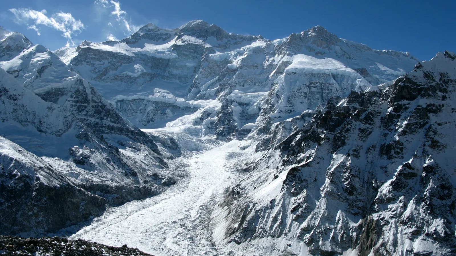
Kanchenjunga Circuit
A remote 21-day circuit of the world's third-highest mountain: the north base camp at Pangpema, three passes between 4,600 and 4,700 m, and the Yalung glacier at Ramche.
- Hari21
- Ketinggian maks.5.140 m
- Jarak138 km
- Pendakian7.761 m
- KesulitanSulit
- Bulan terbaikMar–May, Oct–Nov
- Izin3
Rencanakan trip dengan rencana perjalanan iniCari partner untuk Kanchenjunga CircuitLihat keberangkatan per minggu
Foto: Tomabarker · CC BY 3.0
Ditampilkan dalam bahasa Inggris — belum diterjemahkan.
Rencana perjalanan ini masih draf dan belum diverifikasi. Selalu konfirmasikan tahapannya dengan pemandu Anda.
Written by FindTrekkingPartner teamDitinjau oleh FindTrekkingPartner teamCara kami meninjauFindTrekkingPartner
Kanchenjunga Circuit adalah trek 21 hari di wilayah Kanchenjunga, Nepal, yang mendaki hingga 5.140 m. Trekker asing dapat mencari teman untuk trek ini di FindTrekkingPartner dengan memposting trip berisi tanggal, anggaran, dan kecepatan mereka. Kecocokan tetap privat sampai kedua trekker setuju, dan layanannya gratis. Pada tarif menengah, pemandu berlisensi memerlukan sekitar USD 196 per orang selama 21 hari jika empat trekker berbagi, dibandingkan USD 784 untuk satu trekker sendirian. Musim terbaik adalah Mar–May, Oct–Nov. Ini adalah area terbatas, sehingga pemandu berlisensi yang disewa melalui agen terdaftar menjadi bagian dari izin, dan seluruh grup bepergian dengan satu izin agen. Trip terbuka untuk rute ini tercantum di bawah, lengkap dengan bulan berangkat, ukuran grup, dan sisa tempat. Terakhir diverifikasi: 19 Oktober 2026. Sumber: Nepal Tourism Board, DNPWC, Department of Immigration.
Sumber:Department of Immigration, NepalNepal Tourism BoardDepartment of National Parks and Wildlife Conservation
Cari teman untuk Kanchenjunga Circuit
- Cari teman untuk Kanchenjunga Circuit1 trip terbuka
Ikhtisar
Mulai dari KathmanduPass: Sele La, Mirgin La, Sinelapche La21 hari · maks. 5.140 m
Musim terbaik: Mar–May, Oct–Nov · Izin: Kanchenjunga restricted area permit (Department of Immigration, via a registered agency), Kanchenjunga Conservation Area entry permit, TIMS card where required
The Kanchenjunga Circuit is a 21-day trek around the Nepal side of the world's third-highest mountain, 8,586 m, in Taplejung District. It flies from Kathmandu to Bhadrapur, drives to Taplejung and Sekathum, follows the Ghunsa Khola up to Pangpema, the north base camp at about 5,140 m, then crosses the Sele La, Mirgin La and Sinelapche La to Tseram and Ramche on the Yalung glacier, and descends to Yamphudin for the drive out. It is a restricted-area trek that needs a Restricted Area Permit through a registered agency, the Kanchenjunga Conservation Area permit and a licensed guide. The route covers about 143 km on foot with 8,200 m of climbing, and it suits fit, experienced trekkers with previous high-altitude walking. Lodges are simple, and many agencies camp at the highest stops. October to November and April to May are the best months, and you should keep spare days for weather.
What the trek is like
The trail leaves the road at Sekathum, a warm, terraced valley at about 1,850 m, and climbs through bamboo, rhododendron and fir forest on a clearly marked path. At Ghunsa (3,440 m) you reach a Sherpa and Tibetan-speaking village with a monastery, and the scenery becomes open yak pasture. Above Kambachen the valley widens into moraine and glacier views of Jannu, Kangbachen and the north face of Kanchenjunga, ending at Pangpema. After a rest at Ghunsa you cross the three passes in one long day and drop to Tseram, then walk up to Ramche for the view of the Yalung glacier and the south face. The final days descend through terraced Limbu villages to the road.
Highlights
- Pangpema, the north base camp, with the north face of Kanchenjunga above the Kangchenjunga glacier
- Ghunsa, the highest year-round village, and Kambachen below Jannu
- Three passes at 4,640, 4,650 and 4,709 m between Selele and Tseram, according to OpenStreetMap
- Ramche and the Oktang viewpoint above the Yalung glacier
- Rhododendron forest in spring, cardamom terraces and Limbu farm villages in the lower valleys
Permits and rules
You need a Restricted Area Permit from the Department of Immigration, issued through a registered trekking agency, a Kanchenjunga Conservation Area entry permit and, where asked, a TIMS card. A licensed guide must accompany you throughout. Reports of a March 2026 notice say individual foreigners may apply, but the permit still needs an agency and a guide. Fees have changed more than once, so ask the agency for the current amounts and check them with the Department of Immigration and the conservation area office. Carry several copies of your passport and permits for the check posts.
Best season
October and November have the clearest weather, and April and May bring rhododendron and long days. The passes may be snowbound in March and from late November. The monsoon has leeches, landslides and cloud, and winter is very cold. Keep two spare days in case a pass is closed or the road is blocked.
Altitude
The plan sleeps at 3,440 m in Ghunsa, 4,090 m in Kambachen, 4,770 m in Lhonak and 4,210 m in Selele, with rest days at Ghunsa and a day trip to Pangpema from Lhonak. The south side repeats the climb to Ramche at 4,480 m. Ascend slowly, drink water, and be honest about headaches and nausea. Never ascend with symptoms, and descend if they worsen. Discuss altitude medicine with a doctor before you go.
Getting there and away
Fly Kathmandu to Bhadrapur, then drive to Taplejung (9 to 10 hours) and on to Sekathum by jeep (4 to 5 hours). At the end, a jeep from Yamphudin to Taplejung takes 6 to 7 hours in dry weather, followed by the drive to Bhadrapur and the flight back. Flights are often delayed by cloud, so avoid tight onward connections.
Lodges, food and costs
Lodges at Sekathum, Amjilosa, Gyabla, Ghunsa and Kambachen serve dal bhat, noodles, eggs and tea in simple rooms. Higher up, Lhonak, Selele, Tseram and Ramche have small seasonal lodges or camps, so many groups carry tents and a cook. Prices rise with altitude because everything is carried in. Bring cash for the whole trek, because there are no machines beyond Taplejung.
Packing list
Broken-in boots, waterproof jacket and trousers, a down jacket, a sleeping bag rated to about minus 15 C, warm gloves and hat, sunglasses, gaiters, microspikes for early or late snow, trekking poles, a headlamp, water purification and a first-aid kit.
Who this trek suits and how to prepare
The circuit suits fit trekkers with previous multi-day experience and comfort at 4,000 to 5,000 m. Prepare with long hill walks with a loaded pack, stair training and, if possible, a warm-up trek at altitude. The long pass day needs good stamina.
The plan at a glance
Days 1 to 3 fly and drive to Sekathum. Days 4 to 6 walk to Amjilosa, Gyabla and Ghunsa, with a rest day on day 7. Days 8 to 10 go to Kambachen, Lhonak and Pangpema and back. Days 11 to 13 return to Ghunsa, climb to Selele and cross the passes to Tseram. Days 14 to 16 visit Ramche and return to Tseram. Days 17 to 19 descend to Tortongdin, Yamphudin and Taplejung, and days 20 and 21 drive to Bhadrapur and fly to Kathmandu.
Extensions
Add a day or two at Ghunsa for weather, take the Oktang walk above Ramche, or visit the Pathibhara temple above Taplejung on the road out. For the north base camp alone, return from Pangpema to Sekathum in the same days as the way up, which cuts about five days.
Practical tips from the trail
- Walking times in the day plan are estimates from distance and climb, checked against operator itineraries; real times differ with pace, load and weather.
- Start early on the pass day and carry lunch, because there are no stops between Selele and Tseram.
- Check snow conditions at Selele before you commit to the passes.
- Keep a warm layer and a rain shell in your day bag all the way.
- Book the return jeep from Yamphudin in advance.
- Carry cash and small notes, as villages have no machines.
Responsible trekking
Take rubbish out, avoid single-use plastic and ask before photographing people and monasteries. Walk clockwise around mani walls, buy from local lodges and do not feed wildlife.
Sorotan
- Pangpema, the north base camp of Kanchenjunga at about 5,140 m
- Ghunsa and Kambachen, high Sherpa villages
- The Sele La, Mirgin La and Sinelapche La passes
- Ramche and the Yalung glacier on the south side
- Rhododendron forest, Limbu villages and cardamom terraces
Peta rute
Data rute dari OpenStreetMap, belum diperiksa tim kami. Gunakan untuk perencanaan, bukan navigasi.
Hari demi hari
Anda tidur 1.670 m lebih tinggi dari malam sebelumnya, di atas pedoman umum 500 m. Berjalanlah perlahan, minum banyak air, dan waspadai sakit kepala atau mual.
Drive north from Bhadrapur through tea country and the hills of Ilam or Phidim to Taplejung, also called Phungling, the district headquarters at about 1,800 m. The road is 9 to 10 hours of winding hill driving, often through cloud and on rough stretches, so travel with water and snacks. You cross several ridges, pass cardamom fields and Limbu villages, and finally climb to Taplejung, a busy bazaar. Check in with the conservation area office if your guide asks, buy cash and spend the night in a lodge.
A short, rough jeep drive of 4 to 5 hours takes you from Taplejung down toward the Tamor valley and up to Sekathum, the roadhead for the north trail at about 1,850 m. It is a warm, terraced hamlet with simple lodges, and the first checkpost for your permits. Meet your porters, sort the loads and walk a short way along the river if your legs need it. Tomorrow starts the climb into the Kanchenjunga valley, so take it easy tonight and keep your passport and permit copies handy.
Anda tidur 590 m lebih tinggi dari malam sebelumnya, di atas pedoman umum 500 m. Berjalanlah perlahan, minum banyak air, dan waspadai sakit kepala atau mual.
The first walking day follows the river, crosses it on a suspension bridge and climbs steadily through terraced fields and bamboo forest to Amjilosa at about 2,440 m. The route is about 8 km with 1,100 m of climbing, so allow 4.5 to 6 hours, with a long uphill at the end. The air is humid and warm, with cardamom and millet around the houses, and leeches can appear in wet weather. Lodges in Amjilosa are simple. Keep your daypack light and drink plenty of water.
Climb from Amjilosa through the forest to Gyabla at about 2,710 m, a short day of about 7 km. The path crosses side streams and runs high above the river, with views of waterfalls and bamboo thickets. Gyabla is a Limbu and Sherpa village of stone houses with a small monastery. You gain only about 660 m, so there is time to rest and wash clothes before the higher stages. Cardamom is a cash crop here, and you may see it drying by the lodges.
Anda tidur 730 m lebih tinggi dari malam sebelumnya, di atas pedoman umum 500 m. Berjalanlah perlahan, minum banyak air, dan waspadai sakit kepala atau mual.
A longer day of about 10 km follows the valley through rhododendron and fir forest to Ghunsa, a Sherpa and Tibetan-speaking village at about 3,440 m. The trail crosses the Ghunsa Khola several times on suspension bridges, with a gain of about 800 m and a final steady climb into open pasture. Ghunsa has a gompa, a school and a village health post. The air is thinner and nights are cold, so put on your warm layers early, and eat well. Tomorrow is a rest day for acclimatisation.
Rest and acclimatise at Ghunsa. Walk slowly to the monastery above the village or take an easy hike up the side valley toward Ghunsa Kharka, returning by the afternoon, then rest, read and drink plenty of water. The aim is to sleep at the same height as the day before, and to let your body adapt. Check your gear, charge power banks if the lodge has solar power, and talk to your guide about the route and weather. Watch for headache, nausea and poor sleep.
Anda tidur 650 m lebih tinggi dari malam sebelumnya, di atas pedoman umum 500 m. Berjalanlah perlahan, minum banyak air, dan waspadai sakit kepala atau mual.
Walk up the Ghunsa Khola from Ghunsa to Kambachen at about 4,090 m, about 10 km with a climb of 730 m. The valley opens into big pastures with views of Jannu and Kangbachen, and you cross landslide zones and wooden bridges. Allow 4 to 5 hours, and keep a steady pace in the thinner air. Kambachen is a seasonal settlement of stone lodges and yak herders' huts at the head of the valley. Nights are cold, so use your down jacket early and keep your bottle from freezing.
Anda tidur 680 m lebih tinggi dari malam sebelumnya, di atas pedoman umum 500 m. Berjalanlah perlahan, minum banyak air, dan waspadai sakit kepala atau mual.
A shorter day of about 9 km climbs on the moraine to Lhonak at about 4,770 m, with the Jannu viewpoint on the way. The walk takes 4 to 5 hours, with a climb of about 670 m, and the views of the Kangchenjunga glacier and its seracs are spectacular. Lhonak is a small seasonal camp on a lake-edge terrace, with simple lodges and cold nights. Rest well, eat plenty and watch for symptoms of altitude sickness. Tomorrow is the long day to the north base camp.
A long day to Pangpema, the north base camp at about 5,140 m, and back to Lhonak. The out-and-back route is about 15 km with 550 m of climbing, taking 9 to 10 hours in good conditions, and the trail follows the moraine of the Kangchenjunga glacier with views of the north face. The air is thin and cold, so start early, carry food and water and keep a warm layer on. You earn the best view of Kanchenjunga from Nepal. Turn around if the weather turns or symptoms appear.
Descend from Lhonak back down the valley to Ghunsa, a long day of about 20 km, with a climb of only 100 m and a loss of 1,420 m. Allow 5 to 7 hours, and set off early. The thicker air helps your appetite and sleep, and the trail passes Kambachen and the big pastures you climbed earlier. Ghunsa feels warm after Lhonak, and its lodges have hot meals. Your knees will notice the descent, so use poles and take short breaks.
Anda tidur 770 m lebih tinggi dari malam sebelumnya, di atas pedoman umum 500 m. Berjalanlah perlahan, minum banyak air, dan waspadai sakit kepala atau mual.
Leave Ghunsa and climb south-west to Selele at about 4,210 m, a short but steep day of about 6 km with a climb of 840 m. The trail climbs through forest and open pasture above the tree line, with views back toward Jannu. Selele is a small seasonal camp, and from here the three passes lie ahead. Rest, hydrate and prepare for tomorrow's long crossing. The forecast matters: if snow is falling or fresh, your guide may delay a day. Check the weather forecast with your guide before bed.
The big pass day. From Selele you cross the Sele La at about 4,640 m, the Mirgin La at about 4,650 m and the Sinelapche La at about 4,709 m, then descend to Tseram at about 3,860 m. The route is about 9 km, with 610 m of climbing and 940 m of descent, but it is slow, rocky and exposed, so allow 6 to 8 hours. Carry lunch, water and warm layers, start early and keep together. Views of Jannu and Kabru on clear days are worth the effort.
Anda tidur 620 m lebih tinggi dari malam sebelumnya, di atas pedoman umum 500 m. Berjalanlah perlahan, minum banyak air, dan waspadai sakit kepala atau mual.
Walk up the valley from Tseram to Ramche at about 4,480 m, about 7 km with a climb of 620 m, taking 3 to 4 hours. The trail runs on the moraine through rhododendron, juniper and dwarf bushes with views of Kabru, Rathong and the Yalung glacier. Ramche is a seasonal camp with a few lodges and a small gompa, and it faces the south side of Kanchenjunga. After arriving, rest and drink water. Tomorrow is a short exploration day. Keep a steady pace, because the altitude gain adds up.
A rest and acclimatisation day at Ramche. Walk up the path toward Oktang, on the way to the Kanchenjunga south base camp, for about 3 to 4 hours there and back. The route climbs about 290 m on a clear path to a viewpoint above the Yalung glacier with views of the south face and the Yalung Kang peak. Do not go beyond the signed viewpoints without your guide. Return to Ramche for lunch and rest. The nights are very cold, so keep a warm sleeping system.
Descend from Ramche to Tseram, about 7 km and 600 m down in 2 to 3 hours, retracing the moraine and forest trail. The lower air feels thick and warm, and you can enjoy the views you missed on the way up. Tseram has a few lodges and camping fields in a quiet valley. Use the afternoon to rest, wash and dry gear. Tomorrow is a long descent through forest toward the Limbu villages. Take photographs on the way down, because the morning light shows the Yalung glacier at its best.
Walk from Tseram down the valley to Tortongdin, at about 3,000 m, a descent of about 870 m over 8.6 km. Allow 2 to 3.5 hours for the walk, longer if the path is wet. The trail passes through rhododendron and fir forest, crossing the stream on logs and bridges. Tortongdin has a few simple lodges and a small shrine. Spend the afternoon resting, because tomorrow is a long, steep day to Yamphudin. Pack your rain jacket in the top of the bag, because forest showers are common.
A long descent from Tortongdin to Yamphudin at about 1,700 m, about 13 km with 2,080 m of descent and 770 m of climbing. Allow 5 to 7 hours, and take poles, because the knees take a pounding. The trail crosses forest, ridges and cardamom fields to the first Limbu village on this side, with homestays and shops. It is warm and humid after the high camps, and leeches can appear in wet weather. Yamphudin is a base for the jeep road out.
A jeep from Yamphudin to Taplejung, about 6 to 7 hours in dry weather, passing Khebang and Phumphedanda on a rough road that can be blocked by landslides in the monsoon. Your guide will arrange the vehicle. The drive crosses ridges and the Tamor valley with views of tea gardens and terraces. Taplejung is a good place for a hot shower, a laundry and a last meal of the trek. Use the afternoon to rest and pack. Check the vehicle and the road conditions with your guide the evening before.
A long drive from Taplejung to Bhadrapur or Birtamod, about 9 to 10 hours, descending from the hills into the Terai plains. The road is winding, with stops for lunch and views of tea gardens near Ilam. Travel with water and snacks, and expect the heat to rise sharply as you descend. Check into a hotel near the airport, and plan an early night. If your flight is tomorrow morning, arrive in good time and keep your documents ready. If the road is delayed by landslides, your agency will arrange a hotel for an extra night.
Anda tidur 1.300 m lebih tinggi dari malam sebelumnya, di atas pedoman umum 500 m. Berjalanlah perlahan, minum banyak air, dan waspadai sakit kepala atau mual.
Fly from Bhadrapur back to Kathmandu, about one hour, and transfer to your hotel. The flight offers a final view of Kanchenjunga and the Himalaya on clear mornings. Back in Kathmandu, you can shower, repack and explore Thamel. Keep a spare day after the trek in case the flight is delayed. Tip your guide and porters according to your agency's guidelines, and celebrate a hard and rewarding journey with a good meal. Keep your passport and permit copies in your hand luggage for the airport checks.
Aklimatisasi
Ketinggian tempat tidur malam demi malam. Batang merah naik lebih dari 500 m dari malam sebelumnya; hari istirahat ditandai.
- Ketinggian tempat tidur
- Kenaikan lebih dari 500 m
- Hari istirahat
Biayanya
Perkiraan biaya total per orang: lodge dan makanan menurut ketinggian, transportasi, izin, serta pemandu dan porter. Semakin banyak trekker berbagi pemandu dan porter, semakin sedikit yang dibayar tiap orang. Per Oktober 2026.
| Gaya | 1 trekker berbagi | 2 trekker berbagi | 4 trekker berbagi |
|---|---|---|---|
| Hemat | US$1.150–US$1.700* | US$870–US$1.300* | US$730–US$1.100* |
| Menengah | US$1.500–US$2.350* | US$1.100–US$1.700* | US$1.000–US$1.500* |
| Nyaman | US$1.700–US$2.600* | US$1.450–US$2.200* | US$1.300–US$1.950* |
Bagi pemandu, hemat uang
Pada kisaran menengah, trekker solo membayar sekitar US$1.500–US$2.350; empat trekker berbagi satu pemandu dan dua porter membayar sekitar US$1.000–US$1.500 per orang (36% lebih murah di ujung atas kisaran).
Rincian untuk 2 trekker berbagi
| Item | Hemat | Menengah | Nyaman |
|---|---|---|---|
| Lodge dan makanan | US$490–US$760 | US$650–US$990 | US$850–US$1.300 |
| Izin | US$80–US$90 | US$80–US$90 | US$80–US$90 |
| Pemandu | US$280–US$430 | US$280–US$430 | US$280–US$430 |
| Porter | — | US$110–US$200 | US$230–US$390 |
Hemat memakai transportasi umum dan tanpa porter; menengah berbagi satu porter untuk dua trekker dan kendaraan pribadi; nyaman memberi setiap trekker seorang porter. Pemandu disertakan jika diwajibkan atau gayanya menengah atau nyaman.
Lodge dan makanan per malam (kamar dan seporsi dal bhat)
7 malam Below 2,500 m: kamar US$2–US$9, dal bhat US$4–US$7 · 5 malam 2,500 to 3,800 m: kamar US$4–US$11, dal bhat US$5–US$11 · 8 malam Above 3,800 m: kamar US$7–US$19, dal bhat US$8–US$13
Biaya izin (sumber resmi)
Tidak termasuk
Tidak ditemukan harga yang dipublikasikan untuk: Kathmandu to Bhadrapur flight (return); Bhadrapur to Taplejung and Taplejung to trailhead jeeps. Total bertanda * tidak menyertakannya; tanyakan ke agen Anda. Flights and jeep legs marked check have no published fare in our sources. Many stops are basic lodges or camps.
Sumber biaya
- PriceNepal: Nepal Travel Cost Guide 2026 (2026-05-14)
- Third Rock Adventures: Nepal trek budget planner (2026-05-09)
- Himalayan Partner: Guide and porter price in Nepal 2026 (2026-02-10)
- Shikhar Adventure: Annapurna Circuit trek cost (2026-02-03)
- Kantipur: Suketar-Kathmandu flight fare (2026-04-06)
Perkiraan dari panduan operator, bukan penawaran harga. Tip, asuransi, perlengkapan, dan hotel di Kathmandu tidak termasuk; USD dengan kurs platform.
Foto
Pertanyaan yang sering diajukan
Hard. It is long, remote and high, with several nights above 4,000 m, a pass day of 6 to 8 hours and basic lodges. Previous multi-day trekking experience is needed.
Yes: a Restricted Area Permit through a registered agency, the Kanchenjunga Conservation Area permit and a licensed guide. Reports of a March 2026 notice say individuals may apply, but confirm the current rule.
Twenty-one days from Kathmandu on this plan, including the flight to Bhadrapur and two long drives. Many agencies allow 24 to 27 days for weather and acclimatisation.
Pangpema is at about 5,140 m, and the passes between Selele and Tseram reach about 4,700 m. Ramche is at about 4,480 m.
October and November, and April and May. March and late November can have snow on the passes, and the monsoon is wet.
Yes. Many agencies sell Pangpema alone as a 16 to 18 day out-and-back trek, which skips the passes and the south side.
Lodges exist up to Kambachen, and at Lhonak, Selele, Tseram and Ramche there are small seasonal lodges or camps. Agencies often carry tents and a cook for the upper stages.
Sumber
- Kanchenjunga Circuit itinerary (KimKim)
- Top three itineraries for the Kanchenjunga Circuit (Nepal Trekking Experts)
- Kangchenjunga (Wikipedia)
- Kanchenjunga Conservation Area (Wikipedia)
- Department of Immigration, Nepal
- Restrictions on trekking for foreigners in controlled areas of 13 districts (Kantipur, 6 May 2026)
- Department of National Parks and Wildlife Conservation, Nepal
- Nepal Tourism Board
- Himalayan Rescue Association
- OpenStreetMap (elevation tags of passes, peaks and villages)
Di sepanjang jalur
Penginapan, bantuan medis, air, dan pemandangan di setiap hari rute.
1. Kathmandu → Bhadrapur
- Tribhuvan International Airport · Bandara & transportasi · 1.340 m
2. Bhadrapur → Taplejung
- Taplejung Airport · Bandara & transportasi · 2.419 m
3. Taplejung → Sekathum
Belum ada yang dipetakan untuk hari ini.Belum ada yang dipetakan untuk hari ini.4. Sekathum → Amjilosa
- Sekathum Itahari Guest House · Penginapan · 1.605 m
- Ithari Hotel & Lodge · Penginapan · 1.673 m
- Lama Tar Guest House · Penginapan · 1.903 m
5. Amjilosa → Gyabla
Belum ada yang dipetakan untuk hari ini.Belum ada yang dipetakan untuk hari ini.6. Gyabla → Ghunsa
- Lhasa Guest House · Penginapan · 3.240 m
- Dzonga family house Ghunsa · Penginapan · 3.420 m
7. Ghunsa
Belum ada yang dipetakan untuk hari ini.Belum ada yang dipetakan untuk hari ini.8. Ghunsa → Kambachen
Belum ada yang dipetakan untuk hari ini.Belum ada yang dipetakan untuk hari ini.9. Kambachen → Lhonak
Belum ada yang dipetakan untuk hari ini.Belum ada yang dipetakan untuk hari ini.10. Lhonak
- Kanchenjunga Iceland Guest House Lonak · Penginapan · 4.750 m
- Kanchenjunga Iceland Guest House · Penginapan · 4.750 m
- KBC teahouse · Penginapan · 5.138 m
- Kangchenjunga North Base Camp · Penginapan · 5.137 m
11. Lhonak → Ghunsa
- Kanchenjunga Iceland · Penginapan · 4.753 m
- Kaanchenjunga white house · Penginapan · 4.090 m
- Jannu Phaktanglung View Point · Titik pandang · 4.006 m
12. Ghunsa → Selele
- Selele · Penginapan · 3.415 m
- Kanchenjunga guest house · Penginapan · 3.413 m
13. Selele → Tseram
- Hillside Lodge · Penginapan · 4.238 m
- Sele La · Alam · 4.640 m
- Viewpoint · Titik pandang · 4.614 m
- Mirgin La · Alam · 4.650 m
- Sinelapche La · Alam · 4.709 m
14. Tseram → Ramche
- Upper-Tseram · Penginapan · 4.094 m
15. Ramche
- Okhordung (Oktang) · Titik pandang · 4.766 m
16. Ramche → Tseram
- 8586 · Penginapan · 3.881 m
17. Tseram → Tortongdin
- Alojamiento · Penginapan · 2.999 m
18. Tortongdin → Yamphudin
Belum ada yang dipetakan untuk hari ini.Belum ada yang dipetakan untuk hari ini.19. Yamphudin → Taplejung
Belum ada yang dipetakan untuk hari ini.Belum ada yang dipetakan untuk hari ini.20. Taplejung → Bhadrapur
Belum ada yang dipetakan untuk hari ini.Belum ada yang dipetakan untuk hari ini.21. Bhadrapur → Kathmandu
Belum ada yang dipetakan untuk hari ini.Belum ada yang dipetakan untuk hari ini.
Terakhir diverifikasi pada 19 Okt 2026Laporkan info yang sudah usang