

Fly from Kathmandu to Nepalgunj, a flight of 45 to 60 minutes south-west to the hot plains of the Terai near the Indian border. Nepalgunj is the hub for far-west flights, and it is often very hot. Transfer to your hotel, meet the guide and crew and check the permits. The Simikot flight goes in the morning and the baggage allowance is strict, so repack carefully and leave excess luggage at the hotel. Drink plenty of water, eat early and rest; the next day's flight is weather dependent.
Limi Valley Trek
An 18-day restricted-area loop: fly to Simikot, follow the Humla Karnali to Hilsa and over the Nara La to Til, Halji and Jang, return over the Nyalu La and walk back to Simikot.
- Hari18
- Ketinggian maks.4.940 m
- Jarak193 km
- Pendakian8.448 m
- KesulitanSulit
- Bulan terbaikApr–Jun, Sep–Nov
- Izin2
Rencanakan trip dengan rencana perjalanan iniCari partner untuk Limi Valley TrekLihat keberangkatan per minggu
Foto: Wang Lama · CC BY-SA 4.0
Ditampilkan dalam bahasa Inggris — belum diterjemahkan.
Rencana perjalanan ini masih draf dan belum diverifikasi. Selalu konfirmasikan tahapannya dengan pemandu Anda.
Written by FindTrekkingPartner teamDitinjau oleh FindTrekkingPartner teamCara kami meninjauFindTrekkingPartner
Limi Valley Trek adalah trek 18 hari di wilayah Humla, Nepal, yang mendaki hingga 4.940 m. Trekker asing dapat mencari teman untuk trek ini di FindTrekkingPartner dengan memposting trip berisi tanggal, anggaran, dan kecepatan mereka. Kecocokan tetap privat sampai kedua trekker setuju, dan layanannya gratis. Pada tarif menengah, pemandu berlisensi memerlukan sekitar USD 168 per orang selama 18 hari jika empat trekker berbagi, dibandingkan USD 672 untuk satu trekker sendirian. Musim terbaik adalah Apr–Jun, Sep–Nov. Ini adalah area terbatas, sehingga pemandu berlisensi yang disewa melalui agen terdaftar menjadi bagian dari izin, dan seluruh grup bepergian dengan satu izin agen. Trip terbuka untuk rute ini tercantum di bawah, lengkap dengan bulan berangkat, ukuran grup, dan sisa tempat. Terakhir diverifikasi: 19 Oktober 2026. Sumber: Nepal Tourism Board, DNPWC, Department of Immigration.
Sumber:Department of Immigration, NepalNepal Tourism BoardDepartment of National Parks and Wildlife Conservation
Cari teman untuk Limi Valley Trek
- Cari teman untuk Limi Valley TrekBelum ada trip terbuka
Ikhtisar
Mulai dari KathmanduPass: Nara La, Lamka La, Nyalu La18 hari · maks. 4.940 m
Musim terbaik: Apr–Jun, Sep–Nov · Izin: Humla restricted-area permit (Department of Immigration, via a registered agency), TIMS card issued through a registered agency
The Limi Valley trek is an 18-day loop through the far north-west of Nepal, from Simikot, the district capital of Humla, up the Humla Karnali to Hilsa on the Tibet border and over the Nara La to the three Limi villages of Til, Halji and Jang. It flies from Kathmandu to Nepalgunj and on to Simikot, walks through Dharapuri, Kermi, Yalbang, Tumkot and Yari to Hilsa, crosses the Lamka La to Til, visits Halji and Jang, then takes the long wilderness stages via Talung and the Nyalu La to Shinjungma, returns to Kermi and Simikot, and flies out. The walking covers about 190 km with 8,400 m of climbing, following four operator itineraries. Humla is a restricted area: the Nepal Tourism Board lists the permit at USD 50 per person for the first week, plus USD 10 per day after, through a registered agency, with a licensed guide. The seasons are April to June and September to November, and the flights need spare days.
What the trek is like
The first six days follow the Karnali upstream through pine forest and Tibetan-influenced villages with stone houses and monasteries. After Hilsa the valley opens into the high Limi plateau, with barley fields and juniper, then the three villages. The trek's second half is a remote loop with no villages for two days before Kermi.
Permits and rules
The restricted-area permit is arranged through a registered trekking agency. The Nepal Tourism Board gives the fee as USD 50 per person for the first week and USD 10 per day beyond it. A licensed guide through a registered agency is required. Since 22 March 2026 one trekker can apply, so a group of two is no longer a minimum, but a partner halves the guide cost. A TIMS card is also arranged by the agency.
Best season
April to June and September to November; avoid December to February. Passes need clear weather, and the monsoon brings landslides and flight cancellations.
Altitude
You climb from Simikot at about 2,950 m to Yari at about 3,700 m in four days and cross the Nara La at about 4,620 m. The highest night is Talung at about 4,370 m, below the Nyalu La at about 4,940 m. There are no spare acclimatisation days in this plan, so build one into the Hilsa to Til section or add a day at Jang.
Getting there and away
Fly Kathmandu to Nepalgunj and on to Simikot, then reverse. Flights are often delayed by weather, so keep at least two spare days at the end.
Lodges, food and costs
Facilities are scarce, so the agency supplies the crew, tents and food, with homestays where available. See the costs section for the sourced permit fee and sample costs.
Extensions
You can extend the trek by adding rest days at Jang or Halji, or by continuing from Hilsa towards the Kailash pilgrimage route, which has its own border rules.
Sorotan
- The Humla Karnali gorge from Simikot to the Tibet border at Hilsa
- Til, Halji and Jang, three Tibetan villages at 3,700 to 4,100 m
- Rinchenling monastery in Halji, a Drikung Kagyu temple
- The Nara La (about 4,620 m) and the Nyalu La (about 4,940 m)
- One of the most remote trekking circuits in Nepal
Peta rute
Data rute dari OpenStreetMap, belum diperiksa tim kami. Gunakan untuk perencanaan, bukan navigasi.
Hari demi hari
Anda tidur 2.800 m lebih tinggi dari malam sebelumnya, di atas pedoman umum 500 m. Berjalanlah perlahan, minum banyak air, dan waspadai sakit kepala atau mual.
Fly from Nepalgunj to Simikot in a small plane, about 40 to 45 minutes over the Churen Himal, landing on the high strip above the town at about 2,900 to 2,950 m. Simikot is the district capital of Humla, with a bazaar, a hospital and a few lodges. Flights are often delayed by wind or cloud, and the day may turn into a wait at the airstrip. Walk around the town, drink water and let the body adjust to the altitude. Your crew will finalise loads for the porters.
The first walk descends from Simikot over a ridge and through forest, passing the village of Majgaon, to Dharapuri at about 2,300 m, near the Humla Karnali. Operators give 4 to 5 hours; our mapped route is about 9 km with a net descent. The path has a short climb to a pass at about 3,000 m, then a long descent. Dharapuri is a lower, warmer village on the river, with fields and a few lodges or camping areas. You will start to hear the Karnali from here on.
Follow the Humla Karnali upstream to Kermi, at about 2,670 m, in about 4 hours and 10 km. The path runs through pine forest, villages and fields, with the river always nearby, though on our mapped route it follows tracks and roads that run along the valley. Kermi is known for its hot springs, so you can soak your legs after the walk. There are lodges and camping places. It is an easy day, so use it to get your pace right and drink well, because the altitude rises quickly over the following days.
Continue up the Karnali, crossing a small pass and a suspension bridge over the Salli river, to Yalbang, at about 3,020 m. Operators give 5 to 6 hours for the 11 km, with about 600 m of climbing. The first Tibetan-style village on the route has stone houses and a gompa. Walk gently, as you gain height quickly; sleeping above 3,000 m, you may feel the first headache. The crew can pitch tents near the village or use basic lodging, and the river valley opens up around you.
Climb gradually to Tumkot, at about 3,380 m, passing farms and rocky slopes on a walk of 5 to 6 hours and about 14 km. Tumkot has the Dhungkar Choezom monastery, mentioned in operator itineraries, and a pleasant setting above the river. Operators sometimes stop at Muchu instead, a shorter walk of about 4 hours that splits the day. The air is dry here and the sun strong, so use sun cream and carry plenty of water, since the slopes give little shade. Keep an eye on how everyone in the group is feeling, as the nights now start above 3,000 m.
Pine gives way to juniper as you climb above 3,500 m, on a walk of 4 to 5 hours and about 14 km to Yari, at about 3,700 m, near the first high-altitude pastures. Some groups camp a little beyond at Thado Dunga, about 30 minutes further. Keep a slow pace, drink often and watch your appetite and sleep. Tomorrow is the first pass, the Nara La, so go to bed early and check that your jacket, hat and gloves are within easy reach for the early start.
Cross the Nara La, at about 4,620 m, in a long day of 6 to 7 hours and about 20 km on our mapped route, with about 860 m of climbing, then descend to Hilsa, at about 3,720 m, on the Tibet border. The pass is the traditional pilgrim route to Mount Kailash. Hilsa sits on the Karnali beside a bridge to Tibet, with a hospital, and the Great Himalaya Trail's Nepal section ends here. Start early to cross before the wind and cloud, and stay close to your guide.
Follow the upper Karnali towards Limi in 5 to 6 hours, on rocky and in places steep ground, to a campsite at Manepeme at about 3,900 m, beside the river. On our mapped route it is 11 km with a gain of about 700 m, with a mix of tracks and road. The valley is wide and treeless, and you are well into Tibetan country: look for prayer flags, mani walls and herders. The camp is cold at night, so layer up, drink warm drinks and keep your water bottle from freezing.
Cross the Lamka La, at about 4,300 m, and enter the Limi valley, then reach Til, the first of the three Limi villages, at about 4,000 m, after about 6 hours and 12 km. Til is a stone-house village among barley fields, with views of the valley. It is the first of three villages in a very remote valley. The crew camps near the village or arranges homestays. Eat well, rest and take it easy on the second night at altitude.
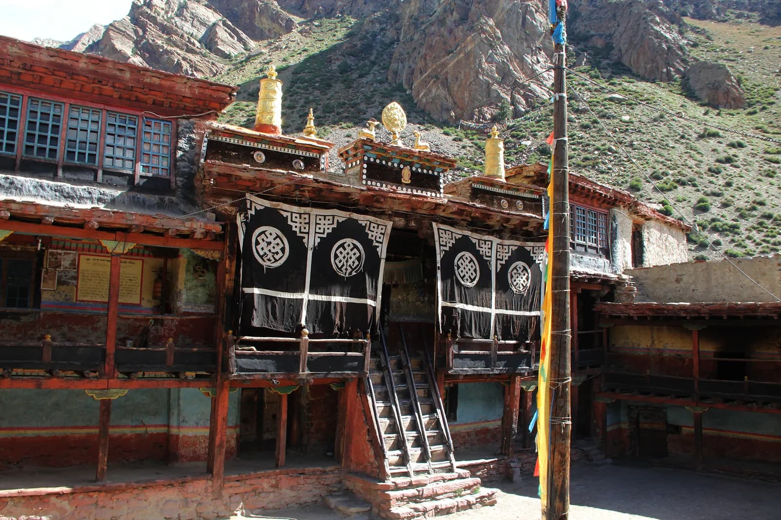
Descend to the Limi river and follow the valley to Halji, the largest Limi village, at about 3,660 m, in about 3 to 4 hours and 9 km. Halji's Rinchenling monastery belongs to the Drikung Kagyu school, and popular accounts date it to the 11th century, although other scholars place it later. Ask your guide to arrange a visit and be respectful: remove your hat and shoes, ask before taking photos and walk clockwise around chortens. You have time in the afternoon to wander the village lanes.
Walk up the valley to Jang, the highest of the three Limi villages, at about 3,930 m, through barley fields and pasture. Operators give 4 hours for the 9.5 km, and Travels with Teri adds an acclimatisation rest day here. Jang has stone houses, a gompa, mani walls and prayer flags, and the sunsets are fine. The next day starts a long remote stretch, so use the afternoon to check your gear, repack and charge devices. You will not see a village again until Kermi.
A long, empty stage of about 8 hours and 17 km climbs to Talung, at about 4,370 m, the highest overnight of the trek. There are no villages until Kermi, so this is the start of a wilderness section. The trail follows the valley across open slopes and passes small herders' camps. Pace yourself and drink often: you sleep above 4,000 m and tomorrow is the hardest day. Use your layers and a warm sleeping bag; frost is common at the camp.
The hardest day: a long climb to the Nyalu La, at about 4,940 to 5,000 m depending on the source, then a long descent to Shinjungma, at about 3,620 m. Operators give about 8 hours; our mapped route is 21 km with about 1,300 m of descent. The pass has wide views of the valleys behind and ahead. Start at first light, carry a packed lunch and check the weather: if a storm or heavy snow threatens, your guide may decide to wait. Descend slowly on the loose ground, using poles to save your knees.
Descend through birch and pine forest to the Karnali valley and the hot springs at Kermi, at about 2,670 m, in about 7 hours and 15 km, mostly downhill. The trail drops almost 1,000 m. You return to lodges and a lower, warmer climate, and the evening soak at Kermi is a reward. If you are tired, take the descent slowly: the knees take a beating. Tonight you are back among villages and fields, and the crew will want a celebration dinner.
Walk back to Simikot in about 6 to 7 hours, a day of about 19 km and 1,100 m of climbing, mostly uphill after Dharapuri. Operators split this day in other itineraries (Kermi to Dharapuri, then Dharapuri to Simikot), which makes for a gentler pace. The trail follows the Karnali downstream, then climbs the ridge past Majgaon to Simikot. Check in at a lodge and reconfirm the flight. Keep your boots and poles handy in case the plane is delayed and you need to fill a day.
Fly from Simikot to Nepalgunj, about 40 to 45 minutes, usually in the morning, weather permitting. If the wind keeps the plane on the ground, your agency can arrange a spare day in Simikot. Flights are the most common cause of delay on this trek. In Nepalgunj you transfer to the hotel, wash and rest, then use the afternoon to book the onward flight to Kathmandu or to sort the paperwork with the agency. The town is hot and dusty after the mountains, so drink plenty of water and enjoy a proper shower and a restaurant meal.
Anda tidur 1.250 m lebih tinggi dari malam sebelumnya, di atas pedoman umum 500 m. Berjalanlah perlahan, minum banyak air, dan waspadai sakit kepala atau mual.
Fly from Nepalgunj to Kathmandu, about an hour, and transfer to your hotel. If the Simikot flight ran on schedule, you may be able to take an earlier connection. Back in the capital, hand back any rented gear, settle accounts with the crew and say your thanks, then check that your passport, receipts and permit copies are all in order. Use the evening to eat out, sort photos and rest your legs. If you have a spare day before your international flight, a visit to Patan or Boudhanath will contrast with the remote valleys you have just left.
Aklimatisasi
Ketinggian tempat tidur malam demi malam. Batang merah naik lebih dari 500 m dari malam sebelumnya; hari istirahat ditandai.
- Ketinggian tempat tidur
- Kenaikan lebih dari 500 m
- Hari istirahat
Biayanya
Perkiraan biaya total per orang: lodge dan makanan menurut ketinggian, transportasi, izin, serta pemandu dan porter. Semakin banyak trekker berbagi pemandu dan porter, semakin sedikit yang dibayar tiap orang. Per Oktober 2026.
| Gaya | 1 trekker berbagi | 2 trekker berbagi | 4 trekker berbagi |
|---|---|---|---|
| Hemat | US$1.200–US$1.800* | US$990–US$1.450* | US$870–US$1.250* |
| Menengah | US$1.550–US$2.350* | US$1.250–US$1.850* | US$1.100–US$1.650* |
| Nyaman | US$1.750–US$2.600* | US$1.500–US$2.250* | US$1.400–US$2.050* |
Bagi pemandu, hemat uang
Pada kisaran menengah, trekker solo membayar sekitar US$1.550–US$2.350; empat trekker berbagi satu pemandu dan dua porter membayar sekitar US$1.100–US$1.650 per orang (30% lebih murah di ujung atas kisaran).
Rincian untuk 2 trekker berbagi
| Item | Hemat | Menengah | Nyaman |
|---|---|---|---|
| Lodge dan makanan | US$400–US$640 | US$540–US$850 | US$720–US$1.100 |
| Transportasi | US$200–US$290 | US$200–US$290 | US$200–US$290 |
| Izin | US$150–US$160 | US$150–US$160 | US$150–US$160 |
| Pemandu | US$230–US$360 | US$230–US$360 | US$230–US$360 |
| Porter | — | US$100–US$180 | US$210–US$360 |
Hemat memakai transportasi umum dan tanpa porter; menengah berbagi satu porter untuk dua trekker dan kendaraan pribadi; nyaman memberi setiap trekker seorang porter. Pemandu disertakan jika diwajibkan atau gayanya menengah atau nyaman.
Lodge dan makanan per malam (kamar dan seporsi dal bhat)
3 malam Below 2,500 m: kamar US$2–US$9, dal bhat US$4–US$7 · 10 malam 2,500 to 3,800 m: kamar US$4–US$11, dal bhat US$5–US$11 · 4 malam Above 3,800 m: kamar US$7–US$19, dal bhat US$8–US$13
Biaya izin (sumber resmi)
Tidak termasuk
Tidak ditemukan harga yang dipublikasikan untuk: Nepalgunj to Simikot flight (return). Total bertanda * tidak menyertakannya; tanyakan ke agen Anda. Ini adalah trek berkemah: kru, tenda, dan makanan ditawarkan oleh agen. Camping trek: crew, tents, kitchen and food are quoted by the agency and are not in this estimate.
Sumber biaya
- PriceNepal: Nepal Travel Cost Guide 2026 (2026-05-14)
- Third Rock Adventures: Nepal trek budget planner (2026-05-09)
- Himalayan Partner: Guide and porter price in Nepal 2026 (2026-02-10)
- Shikhar Adventure: Annapurna Circuit trek cost (2026-02-03)
- Nepal Tourism Board: Trekking Permit (2026-10-18)
Perkiraan dari panduan operator, bukan penawaran harga. Tip, asuransi, perlengkapan, dan hotel di Kathmandu tidak termasuk; USD dengan kurs platform.
Foto
Pertanyaan yang sering diajukan
Yes. Humla is a restricted area. The Nepal Tourism Board lists USD 50 per person for the first week and USD 10 per day beyond, arranged through a registered agency. Operators also require a licensed guide.
This plan takes 18 days from Kathmandu to Kathmandu: two days of flights at each end, 14 days on foot and no spare day. Most operators allow 18 to 21 days.
Operators give about 4,940 to 4,949 m; one says 5,001 m. The Nara La is about 4,620 m and the Lamka La about 4,300 m.
Not in this plan, although Travels with Teri adds an acclimatisation day at Jang. Add a day at Til or Jang if you can; flight buffer days are separate.
No. Humla is a restricted area and a licensed guide and a registered agency are required. Since 22 March 2026 one trekker can apply, so you no longer need a group of two, but a partner halves the guide cost.
No. It is a long, remote route with passes above 4,600 m, 14 walking days and slow evacuation. Experience of multi-week high-altitude trekking is expected.
Sumber
Di sepanjang jalur
Penginapan, bantuan medis, air, dan pemandangan di setiap hari rute.
1. Kathmandu → Nepalgunj
- Tribhuvan International Airport · Bandara & transportasi · 1.340 m
Show all 2 places
- Tribhuvan International Airport · Bandara & transportasi · 1.340 m
- Nepalgunj Airport · Bandara & transportasi · 165 m
2. Nepalgunj → Simikot
- Simikot Airport · Bandara & transportasi · 2.818 m
Show all 2 places
- Simikot Airport · Bandara & transportasi · 2.818 m
- Simikot Airpot Helipad · Bandara & transportasi · 2.971 m
3. Simikot → Dharapuri
- Humla District Hospital · Medis · 2.937 m
- Laxmi Aayurbedic Medical Hall · Medis · 2.949 m
- Hotel Panchamukhi · Penginapan · 2.981 m
- Hotel Mansarovar · Penginapan · 2.986 m
- Water_tap · Praktis · 3.036 m
- Raling hotel · Penginapan · 2.990 m
- Drinking Water · Praktis · 3.265 m
- Namaste Shahi Hotel · Penginapan · 2.343 m
Show all 13 places
- Hotel Panchamukhi · Penginapan · 2.981 m
- Laxmi Aayurbedic Medical Hall · Medis · 2.949 m
- Kishan Micro Finance · Praktis · 2.992 m
- Hotel Mansarovar · Penginapan · 2.986 m
- Humla District Hospital · Medis · 2.937 m
- Water_tap · Praktis · 3.036 m
- Raling hotel · Penginapan · 2.990 m
- SB Hotel · Penginapan · 2.995 m
- Sunny Guest House · Penginapan · 3.006 m
- Sun Valley Resort Hotel · Penginapan · 3.022 m
- Drinking Water · Praktis · 3.265 m
- Manshorowar Shari Hotel · Penginapan · 2.483 m
- Namaste Shahi Hotel · Penginapan · 2.343 m
4. Dharapuri → Kermi
- Tarku Khola Hotel · Penginapan · 2.414 m
- Teahouse · Penginapan · 2.490 m
- Kalakaghun Hotel [extremely basic - 2026] · Penginapan · 2.478 m
5. Kermi → Yalbang
- Kermi Camp Side · Penginapan · 2.795 m
6. Yalbang → Tumkot
- Drinking Water · Praktis · 2.980 m
- Riverside Hotel · Penginapan · 3.088 m
- Homestay Yalbang · Penginapan · 3.082 m
- Namkhyung Mahamaya Basic School Playground · Bandara & transportasi · 3.118 m
- Humla Himalyan Hotel - [lot of drunk people] · Penginapan · 3.125 m
7. Tumkot → Yari
- Drinking Water · Praktis · 3.182 m
- Yari Hotel · Penginapan · 3.784 m
8. Yari → Hilsa
- Himalaya Guest House · Penginapan · 3.786 m
- Hotel Snow Lion · Penginapan · 3.643 m
- Special Health Camp · Medis · 3.632 m
- Hilsa Hospital · Medis · 3.639 m
- Khang Jong Limi Hotel · Penginapan · 3.638 m
9. Hilsa → Manepeme
- Hotel Manasovar Restaurant and Bar · Penginapan · 3.633 m
- Sange Hotel and Lodge · Penginapan · 3.630 m
- Himalaya Hotel, Restaurant and Bar · Penginapan · 3.632 m
10. Manepeme → Til
- On the way to Hilsha from Til · Titik pandang · 4.265 m
- Drinking Water · Praktis · 3.933 m
11. Til → Halji
- Drinking Water · Praktis · 3.930 m
12. Halji → Jang
- Drinking Water · Praktis · 3.732 m
13. Jang → Talung
- Limi Resort, Tokche, Tumling · Penginapan · 4.179 m
- Selima Tso · Alam · 4.259 m
14. Talung → Shinjungma
Belum ada yang dipetakan untuk hari ini.Belum ada yang dipetakan untuk hari ini.15. Shinjungma → Kermi
- Salli Lodge and Restaurant · Penginapan · 2.975 m
16. Kermi → Simikot
- Drinking Water · Praktis · 2.373 m
- Dharapori Hotel [Open - 2026] · Penginapan · 2.342 m
- Sunshine Medical Hospital · Medis · 2.955 m
- Simikot lagna · Titik pandang · 3.233 m
- Hotel Bijaya · Penginapan · 3.011 m
- Kailash - 2026 · Penginapan · 3.009 m
- CFD Humla · Penginapan · 3.015 m
- Health Us Nepal Medical Center · Medis · 2.961 m
Show all 11 places
- Chyachhara Jharna · Alam · 2.456 m
- Drinking Water · Praktis · 2.373 m
- Dharapori Hotel [Open - 2026] · Penginapan · 2.342 m
- Manshorowar Shahi Hotel - 2026 · Penginapan · 2.499 m
- Sunshine Medical Hospital · Medis · 2.955 m
- Dada Hotel · Penginapan · 3.271 m
- Simikot lagna · Titik pandang · 3.233 m
- Hotel Bijaya · Penginapan · 3.011 m
- Kailash - 2026 · Penginapan · 3.009 m
- CFD Humla · Penginapan · 3.015 m
- Health Us Nepal Medical Center · Medis · 2.961 m
17. Simikot → Nepalgunj
Belum ada yang dipetakan untuk hari ini.Belum ada yang dipetakan untuk hari ini.18. Nepalgunj → Kathmandu
Belum ada yang dipetakan untuk hari ini.Belum ada yang dipetakan untuk hari ini.
Terakhir diverifikasi pada 19 Okt 2026Laporkan info yang sudah usang