

Khaptad
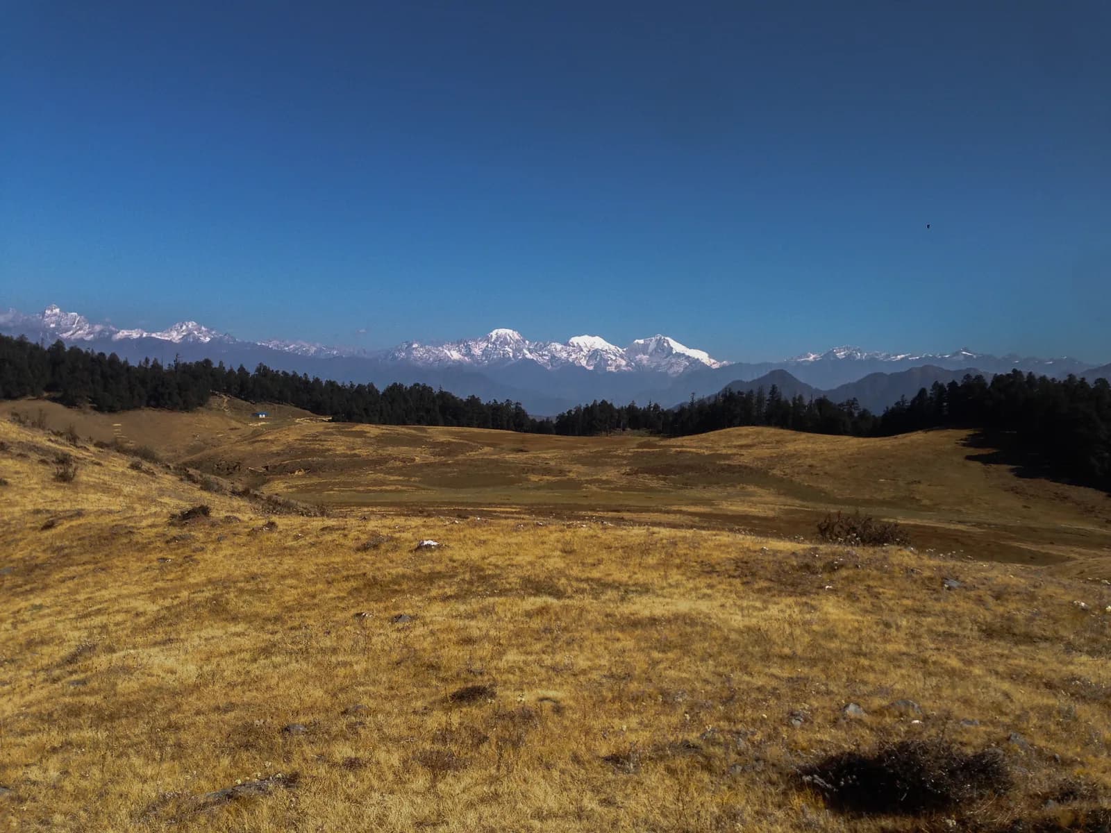
Khaptad is a high meadow plateau at about 3,000 m in far-western Nepal, protected as Khaptad National Park, with the ashram of Khaptad Baba and a sacred lake, reached by flight to Dhangadhi and a long drive to Silgadhi.
- अधिकतम ऊँचाईPark high point (about 3,300 m)
- दिन9–12
- कठिनाईमध्यम
- सबसे अच्छे महीनेMar–May, Oct–Dec
- परमिट2 परमिट
फ़ोटो: Utsab Raj Giri · CC BY-SA 4.0
Check that your policy covers helicopter evacuation and trekking at this region's altitude. We don't sell insurance.
What to look forWritten by FindTrekkingPartner teamFindTrekkingPartner team द्वारा समीक्षितहम समीक्षा कैसे करते हैंFindTrekkingPartner
Khaptad नेपाल का एक ट्रेकिंग क्षेत्र है, जहां 10 दिन के रूट हैं जो 3,276 मीटर तक चढ़ते हैं। विदेशी ट्रेकर FindTrekkingPartner पर अपनी तारीखों, बजट और रफ़्तार के साथ ट्रिप पोस्ट करके यहां के ट्रेक के लिए पार्टनर खोज सकते हैं। मैच तब तक निजी रहते हैं जब तक दोनों ट्रेकर सहमत न हों, और सेवा मुफ़्त है। मध्यम दरों पर लाइसेंस प्राप्त गाइड का खर्च चार ट्रेकर के साझा करने पर 10 दिनों में प्रति व्यक्ति लगभग USD 93 है, जबकि अकेले एक ट्रेकर के लिए USD 373। सबसे अच्छे मौसम Mar–May, Oct–Dec हैं। यहां व्यवहार में लाइसेंस प्राप्त गाइड ज़रूरी है: 2026 के ऑपरेटरों के अनुसार नेपाल पर्यटन बोर्ड का अप्रैल 2023 का नियम राष्ट्रीय उद्यानों और संरक्षण क्षेत्रों की चौकियों पर लागू किया जाता है, जिसमें लांगटांग सबसे सख़्त है और अन्नपूर्णा भी जांच करता है (19 अक्टूबर 2026 को जांचा गया)। पंजीकृत एजेंसी के माध्यम से गाइड रखें और उनसे पुष्टि करें। अंतिम सत्यापन: 19 अक्टूबर 2026। स्रोत: नेपाल पर्यटन बोर्ड, DNPWC, आव्रजन विभाग।
स्रोत:Department of Immigration, NepalNepal Tourism BoardDepartment of National Parks and Wildlife Conservation
- Khaptad National Park Trek के लिए पार्टनर खोजेंअभी कोई खुली ट्रिप नहीं
परिचय
- लाइसेंसधारी गाइड
- विदेशी ट्रेकर्स के लिए ज़रूरी
- न्यूनतम ग्रुप
- 1 ट्रेकर
NTB rule (Apr 2023), enforced at checkpoints in national parks and conservation areas (2026 operator reports; checked 19 October 2026). Khaptad is not a restricted area: the Nepal Tourism Board's Bajhang entry covers only Saipal Rural Municipality. The park entry permit is NPR 3,000 for foreigners. The trails are lightly marked and lodging is sparse, so most visitors go with an agency.
लोकप्रिय ट्रेक
शुरुआती स्थान
Kathmandu, Dhangadhi, Silgadhi, Jhigrana
कैसे पहुँचें
Fly Kathmandu to Dhangadhi (about an hour), then drive about 8 to 9 hours to Silgadhi in Doti, the usual trail start. Another approach is by road or air to Nepalgunj and about 6 hours by road to Silgadhi. Landslides can close roads in the monsoon; flights in the far west are often delayed.
Khaptad is a high grassland plateau in far-western Nepal, protected as Khaptad National Park, where rolling meadows, oak and pine forest, a sacred lake and a hermit's ashram sit at about 3,000 m. The park covers 225 square kilometres across Bajhang, Bajura, Achham and Doti districts and ranges from about 1,400 m to 3,300 m. The usual trek flies from Kathmandu to Dhangadhi, drives about nine hours to Silgadhi, walks up the Jhigrana and Bichpani route onto the plateau, and returns the same way, in nine or ten days. It is not a restricted area, the foreign entry fee is NPR 3,000, lodging is sparse, and the best months are March to May and October to December. Few foreigners come, so the plateau is quiet, and the walk gives a rare look at the far west without a long expedition.
About Khaptad National Park
Khaptad National Park was established in 1984, on the advice of the ascetic known as Khaptad Baba, according to Wikipedia. It covers 225 square kilometres in four districts of the far west, Bajhang, Bajura, Achham and Doti, and a buffer zone of 216 square kilometres was declared in 2006. The elevation runs from about 1,400 m to 3,300 m, and the plateau that gives the park its character lies at about 3,000 m, a broad area of rolling grass called patan, with stands of oak, pine, fir and rhododendron on the edges.
The park's list of life is long for its size. Wikipedia counts 567 flowering plant species, of which 224 are medicinal, 23 mammals, 287 birds and 23 amphibians and reptiles. In summer the meadows carry a spread of wildflowers, and many local families still collect herbs on the park's edge. The plateau feels very different from the high Himalayan treks, since the walking is on soft grass and forest tracks and the views are across rows of hills toward snow peaks on the Saipal horizon.
Khaptad Baba and the sacred sites
The park's spiritual centre is the ashram of Sachidananda Saraswati, known as Khaptad Baba. The Great Himalaya Trail description says that he spent some fifty years meditating at his hermitage in the plateau, that he died in 1996, and that a statue of him stands on the ashram porch. The hermitage is a low house with a slate roof beside an open yard, and pilgrims and trekkers visit it in peace.
Other sites are Tribeni, which the same source describes as the confluence of three streams with a Shiva temple at about 3,010 m, and Sahashra Linga, a hill of many stone lingams at about 3,276 m, the highest point mentioned for the park and a five-hour return walk from the park headquarters. Khaptad Daha is a lake beside the trail towards Kolti, where local people believe Shiva bathed. Treat the ashram, Tribeni and the lake as shrines: dress modestly and keep noise down.
The far west around the park
Silgadhi is the headquarters of Doti District, a district of 2,025 square kilometres in Sudurpashchim Province. Wikipedia explains that Doti was a medieval kingdom, founded by a member of the Katyuri dynasty of Kumaon and ruled by the Raikas, and that it passed to the expanding Nepali kingdom in 1790. The old fort sites and village temples around Dipayal and Silgadhi are a reminder that this corner of Nepal has its own long history and its own dialects and customs, which differ from those of the east.
The park is shared by four districts, and each side has its own access road. The Doti side from Silgadhi is the most used for foreigners. The Bajhang side from Chainpur and Tamail, and the Bajura side from Martadi, are less used and are described by a few operators. The Doti entry gives the clearest trail, and it is the one we map.
How the trek feels
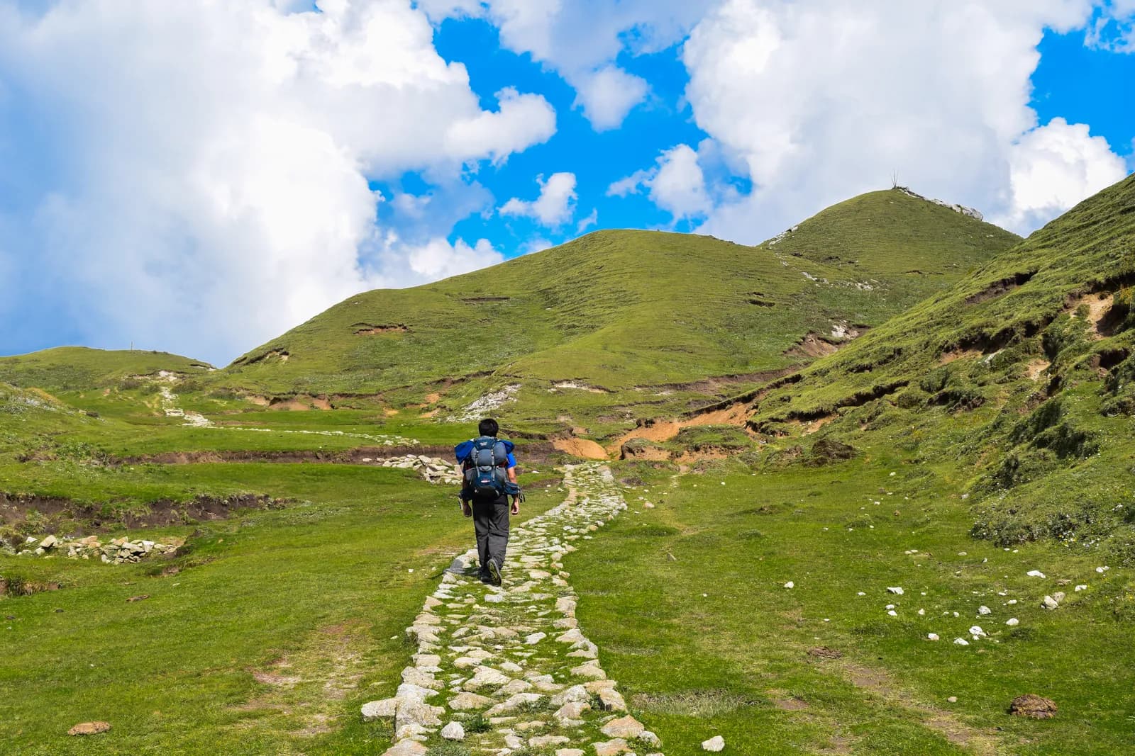
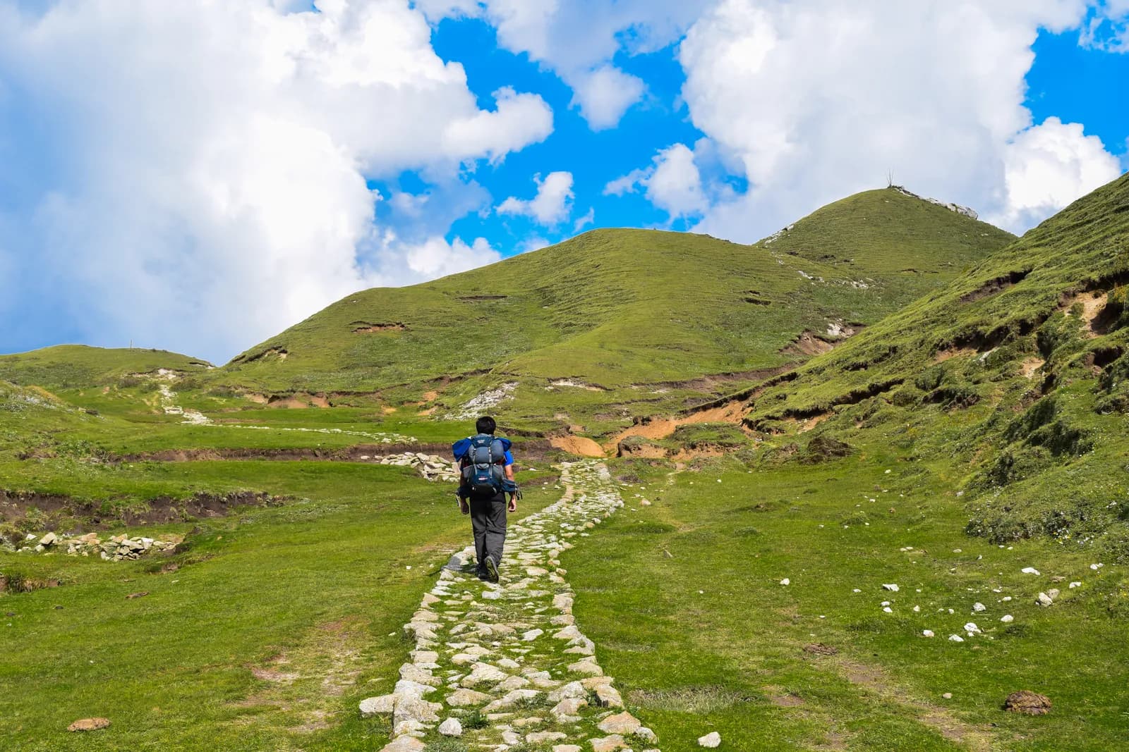
The first walking day is a long climb on the valley road. On our map the 17.7 km from Silgadhi to Jhigrana is mostly on a motor road, about 7 to 8 hours of walking, and some groups hire a vehicle for part of it. The second day, from Jhigrana to Bichpani Camp, is a short and steep 6 km on a marked path through forest, with about 920 m of climbing, and the third crosses nearly level grass for about 9.5 km to Khaptad. That is the best day of the trek: the trail rolls across open meadow, passes stands of oak and fir, and the Saipal range shows on the horizon in clear weather.
The rest day on the plateau is the time for Khaptad Daha, which our map puts at about 3 km from the lodge area, the ashram and, for strong walkers, Sahashra Linga. The way down is the same as the way up, but faster: Khaptad to Jhigrana is a long downhill day of about 15.7 km, and Jhigrana to Silgadhi is another 17.7 km on the road.
Plants and wildlife
The meadows are the feature, and many are carpeted with wildflowers in the summer and early autumn. The forest edge holds oak, pine, fir and rhododendron, and the plateau is known for medicinal herbs that people collect. Birds are the easiest wildlife to see, with 287 species on the park list, and the quiet mornings are the best time. Larger mammals, of which Wikipedia lists 23, keep to the forest and are rarely seen on the trail. Please keep to the paths on the meadows, as the thin turf is easily damaged, and do not pick plants.
Getting there
Access is long. From Kathmandu you can fly to Dhangadhi in about an hour, according to the operator itineraries we read, and then drive about eight to nine hours to Silgadhi, the headquarters of Doti District and the usual trail start. The Great Himalaya Trail page describes a different approach: drive or fly to Nepalgunj, then about six hours by road to Silgadhi. Roads in the west are cut by landslides in the monsoon, so build spare days into the plan, and consider the flight option, since a bus from Kathmandu to Doti takes around twenty hours with changes.
Silgadhi sits at about 1,330 m on the elevation model, and a road now runs up the valley towards Jhigrana, so a vehicle can carry you part of the way on request. The trail itself starts in earnest above Jhigrana, which is at about 2,250 m.
When to go
Operators give March to May and October to December as the best periods. The Great Himalaya Trail page warns that winter snow closes the park from late December to the end of February, and that monsoon rain can close roads and damage infrastructure for weeks. In spring the rhododendron is in flower and the meadows are green; in autumn the air is clear and the grass turns gold. Mid-summer is wet, and the Great Himalaya Trail page mentions a festival fair at Tribeni on a full-moon day.
The Khaptad National Park trek
The standard plan is the Khaptad National Park trek, nine to ten days from Kathmandu to Kathmandu. After the drive to Silgadhi, the first walking day climbs by the valley road to Jhigrana, the second climbs a marked trail to Bichpani Camp, the third crosses the plateau to Khaptad, and the fourth is a day for Khaptad Daha and the ashram. The return retraces the route to Jhigrana and Silgadhi, then drives to Dhangadhi and flies to Kathmandu. On our map the walking is about 72 km with about 3,330 m of climbing.
Other operators describe a different version: one starts in Bajhang at Tamail and finishes at Silgadhi, and another starts from Silgadhi and returns by way of Darugaon and Tamail. The Great Himalaya Trail notes that the most popular option is to return to Silgadhi by the route you came on.
Permits and rules
Khaptad is not in the Nepal Tourism Board's restricted-area list for 2026. The Bajhang entry in that list applies only to Saipal Rural Municipality, which is a different part of the district, so no Department of Immigration permit is needed for a Khaptad trek. The park entry fee is NPR 3,000 per person per entry for foreigners and NPR 1,500 for SAARC nationals, according to the Nepal Tourism Board's park entry fee table. One operator page gives NPR 1,500 as the foreigner fee, which matches the SAARC figure on the official table, so use the official numbers. A TIMS card is listed as a line to check.
Carry your passport for the checkpoints at Jhigrana and the park entrance. A guide is not legally required by a restricted-area rule, but the trails are lightly marked and few people speak English in the villages, so most visitors go with an agency.
Lodging, food and costs
Lodging is sparse. Operators describe tented camps at Bichpani and on the plateau and homestays at several villages, and Silgadhi, Jhigrana and Dhangadhi have simple lodges. Plan this as a camping trek with local staff unless your agency confirms rooms in advance. Our cost estimate adds Nepal-wide lodge and food ranges for the town nights, shows flights and road transfers as lines to check, because we found no published fares, and states that tents, crew and food for the plateau are quoted by the agency.
Altitude and safety
The plateau is at about 3,000 m, so altitude sickness is rare and mild, but the climb from Jhigrana to Bichpani gains about 920 m in a short distance and the second night is above 3,000 m. Weather changes fast on open grassland, with thunderstorms in summer and snow in winter. Help is far away, so go with someone who knows the trails, carry a first-aid kit and a working phone, and never rely on a straight line across the meadows in mist.
Practical tips
- Reserve flights and the road transfer early, because seats to Dhangadhi fill in the main seasons.
- Allow two spare days, because weather and road closures are common.
- Bring a warm sleeping bag, since camp nights at 3,000 m are cold even in spring.
- Carry cash for the park gate and for homestays, because there are no machines on the plateau.
- Respect the ashram and the lake as shrines, and carry out your waste.
Sources and how we checked them
The route plan combines a nine-day operator itinerary that names Silgadhi, Bichpani, Khaptad and the return, an eleven-day operator plan that names Silgadhi, Jhigrana, Bichpani and Khaptad, and the Great Himalaya Trail description. Park facts come from Wikipedia, the entry fee from the Nepal Tourism Board, and the walking distances from our map. Where operators disagree about heights, such as the 2,743 m given for Bichpani, which is far from the elevation model, we leave the number out of the itinerary.
इस क्षेत्र के सभी रूट
यहाँ हमारे कवर किए सभी मानक रूट। किसी रूट पर टैप करके उसका दिन-ब-दिन यात्रा-कार्यक्रम खोलें।
रूट की तुलना करें
अपने लिए सही रूट खोजने के लिए रूट को लंबाई, ऊँचाई, कठिनाई या अनुमानित खर्च से क्रमबद्ध करें।
दिन ↑ के अनुसार क्रमबद्ध
| रूट | |||||
|---|---|---|---|---|---|
| Khaptad National Park Trek | 10 | 3,276 मी | मध्यम | 72.5 किमी | NPR 41,000 से |
खर्च एक अनुमान है: क्षेत्र की बजट-स्टाइल दैनिक दर गुणा दिन, उड़ानों और परमिट के बिना।
ट्रेक के लिए सबसे अच्छा समय
हाइलाइट किए गए महीने ट्रेकिंग के सुझाए गए मौसम हैं। Mar–May · Oct–Dec
सबसे अच्छा मौसमअन्य महीने
Live conditions
Notes entered by our team from the sources linked on each item. Conditions change quickly, so confirm with your guide or lodge before you set off.
Best seasons: Mar–May · Oct–Dec
Nothing recent on file. Check with your guide or lodge before you go.
परमिट और शुल्क
शुल्क प्रति व्यक्ति है और आपके राष्ट्रीयता समूह पर निर्भर करता है।
| परमिट | विदेशी | SAARC | नेपाली |
|---|---|---|---|
Khaptad National Park entry permit | NPR 3,000 | NPR 1,500 | — |
TIMS card (trekking agency issued) | NPR 2,000 | NPR 1,000 | — |
- कहाँ से लें
Department of National Parks and Wildlife Conservation
Trekking agency / Nepal Tourism Board
दैनिक ख़र्च
टीहाउस ट्रेक पर प्रति व्यक्ति प्रतिदिन। गाइड और पोर्टर का ख़र्च प्रति ग्रुप/पोर्टर प्रतिदिन है। अक्टूबर 2026 तक।
Khaptad National Park Trek का सामान्य कुल खर्च, 2 ट्रेकर्स साथ में
- किफ़ायती
- $190–$300
- मध्यम बजट
- $420–$650
- आरामदायक
- $550–$840
| शैली | प्रतिदिन | गाइड / दिन | पोर्टर / दिन | नमूना कुल |
|---|---|---|---|---|
| किफ़ायती | NPR 2,900–4,800 | NPR 5,000 | NPR 2,750 | NPR 21,300–34,800 |
| मध्यम बजट | NPR 4,100–6,500 | NPR 5,000 | NPR 2,750 | NPR 29,700–47,700 |
| आरामदायक | NPR 5,500–8,400 | NPR 5,000 | NPR 2,750 | NPR 40,500–62,400 |
किफ़ायती: The Kathmandu to Dhangadhi flight takes about an hour and the road to Silgadhi 8 to 9 hours. No fares are published in our sources, so both legs are shown as lines to check. Tents, crew and food on the plateau are quoted by the agency.
मध्यम बजट: The Kathmandu to Dhangadhi flight takes about an hour and the road to Silgadhi 8 to 9 hours. No fares are published in our sources, so both legs are shown as lines to check. Tents, crew and food on the plateau are quoted by the agency.
आरामदायक: The Kathmandu to Dhangadhi flight takes about an hour and the road to Silgadhi 8 to 9 hours. No fares are published in our sources, so both legs are shown as lines to check. Tents, crew and food on the plateau are quoted by the agency.
नियम और अच्छे तरीके
गाइड
- सभी क्षेत्र
Foreign trekkers must trek with a licensed guide in national parks and conservation areas (in force since April 2023). Enforcement varies by region, so verify the current rule before you go.
परमिट
- सभी क्षेत्र
Carry your permits at all times; they are checked at several checkpoints along every route.
सुरक्षा और ऊँचाई
- सभी क्षेत्र
Buy travel insurance that covers helicopter rescue to at least 6,000 m.
- सभी क्षेत्र
Climb high, sleep low: above 3,000 m, avoid raising your sleeping altitude by more than about 500 m per day, and add rest days.
संरक्षण
- सभी क्षेत्र
Carry out all non-burnable waste (batteries, plastic, wrappers) and use a refillable water bottle.
संस्कृति
- सभी क्षेत्र
Respect monasteries: walk clockwise around stupas and mani walls, and remove shoes where asked.
- सभी क्षेत्र
Ask before photographing people, especially at religious sites and ceremonies.
ड्रोन
- सभी क्षेत्र
No drones without prior permission from the relevant authority.
फ़ोटो
अक्सर पूछे जाने वाले सवाल
In far-western Nepal, shared by Bajhang, Bajura, Achham and Doti districts. It was established in 1984, covers 225 square kilometres and ranges from about 1,400 m to 3,300 m, according to Wikipedia.
NPR 3,000 per person per entry for foreigners and NPR 1,500 for SAARC nationals, according to the Nepal Tourism Board's park fee table. Some operator pages quote the SAARC figure, so use the official one.
No. The Nepal Tourism Board's restricted list names only Saipal Rural Municipality in Bajhang, which is a different part of the district, so no Department of Immigration permit is needed.
Fly Kathmandu to Dhangadhi, drive about 8 to 9 hours to Silgadhi, and walk up the Jhigrana road. Another route goes through Nepalgunj, then about 6 hours by road. A bus from Kathmandu to Doti takes around 20 hours.
March to May and October to December. The Great Himalaya Trail page says winter snow closes the park from late December to the end of February, and monsoon rain can close roads for weeks.
An ascetic who meditated in the plateau for about fifty years and died in 1996, according to the Great Himalaya Trail page. The park was set up on his advice, and his ashram is a pilgrimage site.
Very little. Operators describe tents at Bichpani and on the plateau and homestays or simple lodges in the villages, so plan it as a camping trek with an agency.
The plateau is at about 3,000 m on the elevation model. The park's high point, Sahashra Linga, is about 3,276 m, according to the Great Himalaya Trail page and an operator.
ओपन ट्रिप
Khaptad के बारे में गाइड
 कवर फ़ोटो: Kunja Shrestha, CC BY-SA 4.0
 कवर फ़ोटो: Nirmal Joshi, CC BY 2.0
 कवर फ़ोटो: McKay Savage from London, UK, CC BY 2.0
 कवर फ़ोटो: Anil Bhatta, CC BY-SA 4.0
 कवर फ़ोटो: Wang Lama Humla, CC BY-SA 4.0
स्रोत
Khaptad ट्रेक के लिए तैयार?
इन तारीखों के लिए ट्रेकिंग पार्टनर खोजें या अपना रूट प्लान करना शुरू करें।