

Leave Kathmandu early for the drive north to Syabrubesi, at about 1,500 m, on the Trisuli road past Trisuli Bazaar and the approach to Langtang. Operators give 6 to 9 hours depending on the vehicle and the state of the road; the bus is slower and cheaper than a jeep. The road is narrow and winding, with some landslide sections. Syabrubesi is the busy start of the Langtang and Tamang Heritage routes, so you will see other trekkers. Check in to a lodge, confirm your permit paperwork with the guide, pack a daypack and have an early night before the first walking day.
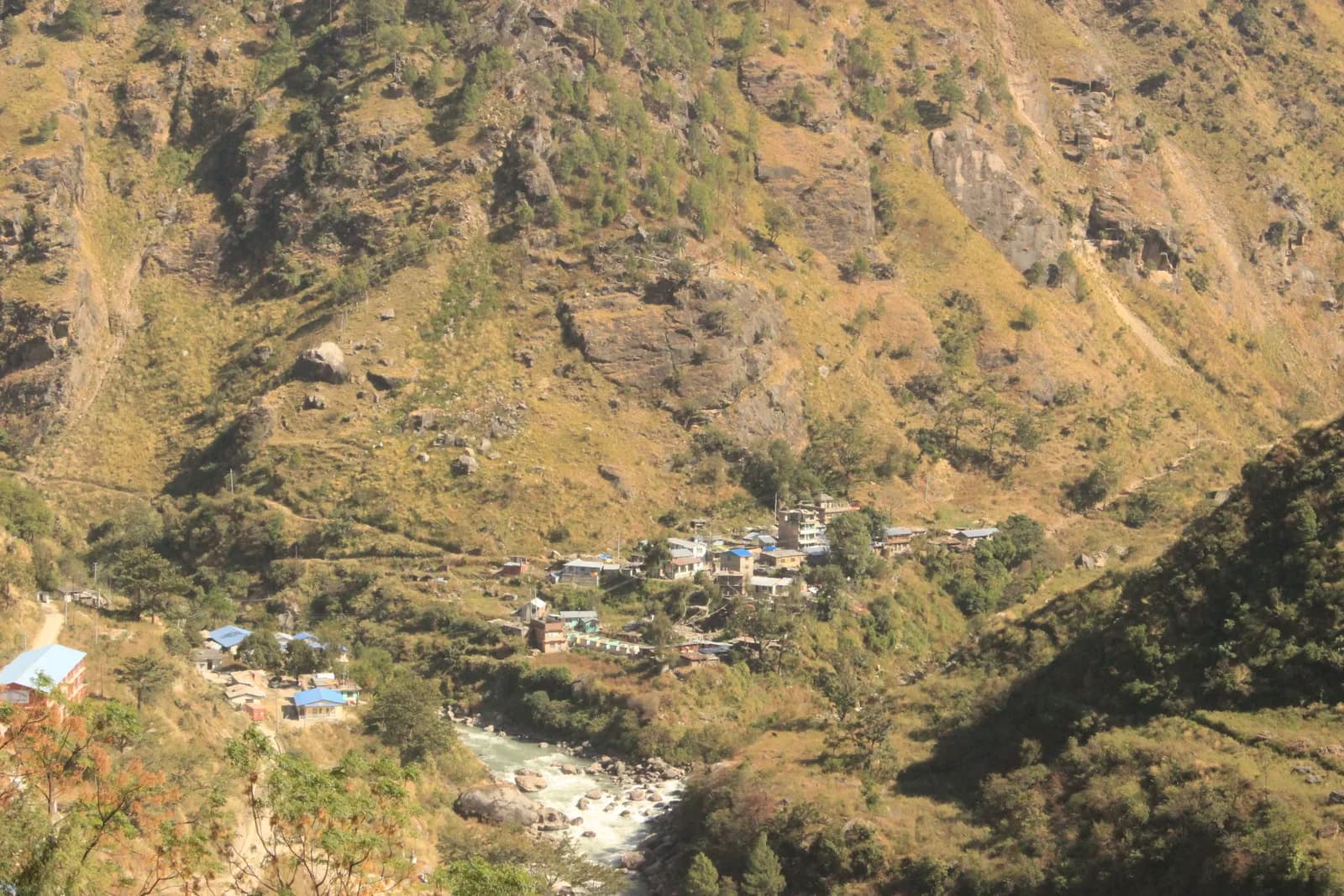
Ruby Valley and Ganesh Himal Trek
A 7-day village trek from Syabrubesi over Pangsang Pass to Tipling and Chalish, with a rest day around Chalish and a drive back through Dhading Besi.
- दिन7
- अधिकतम ऊँचाई3,850 मी
- दूरी43.7 किमी
- चढ़ाई3,638 मी
- कठिनाईमध्यम
- सबसे अच्छे महीनेMar–May, Oct–Nov
- परमिट2
इस यात्रा-कार्यक्रम के साथ ट्रिप की योजना बनाएँRuby Valley and Ganesh Himal Trek के लिए पार्टनर खोजेंहफ़्ते के अनुसार प्रस्थान देखें
फ़ोटो: Rajivkilanashrestha · CC BY-SA 4.0
चेतावनीRuby Valley: the Syabrubesi start is not currently reliable
This route drives to Syabrubesi on day 1 and finishes at Chalish with a drive back through Dhading Besi. On 26 August 2026 a large rock-and-ice collapse from the north face of Langtang Lirung sent a debris flow down the Lhende Khola into the Bhote Koshi and Trishuli rivers, hitting Rasuwagadhi, Timure, Syabrubesi and Betrawati (ICIMOD). Many bridges and long stretches of the Pasang Lhamu Highway were damaged, and a large number of people died or are missing; reported figures differ by source.
Syabrubesi, the usual Langtang road-head, is reported destroyed or closed as a trekking gateway, with the bridge to it swept away; restoration depends on the Betrawati highway reopening. The Trishuli Bazaar-Betrawati-Dhunche road was reported still closed for repair as of 21 September. A light-vehicle track has reopened, and agencies projected the remaining gaps passable no earlier than mid-October; that is a projection, not an official date.
We found no source on the condition of the Ruby Valley trail itself or a reopening date. We found no official reopening notice. Check current road and trail conditions with Langtang National Park and your trekking agency before booking, and do not rely on this summary alone.
स्थिति की जाँच 2026-10-19 को हुई।
स्रोत: ICIMOD: Kyirong-Rasuwa flood, 26 August 2026 · Nepal Pyramids: Langtang Valley trek update after the 2026 flooding · Republica: locals reopen flood-damaged Langtang trekking route (16 Oct)
अंग्रेज़ी में दिखाया गया — अभी अनुवाद नहीं हुआ।
यह यात्रा-कार्यक्रम ड्राफ़्ट है और अभी सत्यापित नहीं हुआ है। चरणों की पुष्टि हमेशा अपने गाइड से करें।
Written by FindTrekkingPartner teamFindTrekkingPartner team द्वारा समीक्षितहम समीक्षा कैसे करते हैंFindTrekkingPartner
Ruby Valley and Ganesh Himal Trek नेपाल के Ganesh Himal क्षेत्र में 7 दिन का ट्रेक है, जो 3,850 मीटर तक चढ़ता है। विदेशी ट्रेकर FindTrekkingPartner पर अपनी तारीखों, बजट और रफ़्तार के साथ ट्रिप पोस्ट करके इसके लिए पार्टनर खोज सकते हैं। मैच तब तक निजी रहते हैं जब तक दोनों ट्रेकर सहमत न हों, और सेवा मुफ़्त है। मध्यम दरों पर लाइसेंस प्राप्त गाइड का खर्च चार ट्रेकर के साझा करने पर 7 दिनों में प्रति व्यक्ति लगभग USD 65 है, जबकि अकेले एक ट्रेकर के लिए USD 261। सबसे अच्छे मौसम Mar–May, Oct–Nov हैं। यहां व्यवहार में लाइसेंस प्राप्त गाइड ज़रूरी है: 2026 के ऑपरेटरों के अनुसार नेपाल पर्यटन बोर्ड का अप्रैल 2023 का नियम राष्ट्रीय उद्यानों और संरक्षण क्षेत्रों की चौकियों पर लागू किया जाता है, जिसमें लांगटांग सबसे सख़्त है और अन्नपूर्णा भी जांच करता है (19 अक्टूबर 2026 को जांचा गया)। पंजीकृत एजेंसी के माध्यम से गाइड रखें और उनसे पुष्टि करें। अंतिम सत्यापन: 19 अक्टूबर 2026। स्रोत: नेपाल पर्यटन बोर्ड, DNPWC, आव्रजन विभाग।
स्रोत:Department of Immigration, NepalNepal Tourism BoardDepartment of National Parks and Wildlife Conservation
Ruby Valley and Ganesh Himal Trek के लिए पार्टनर खोजें
- Ruby Valley and Ganesh Himal Trek के लिए पार्टनर खोजेंअभी कोई खुली ट्रिप नहीं
परिचय
Kathmandu से शुरूदर्रे: Pangsang Pass7 दिन · अधिकतम 3,850 मी
सबसे अच्छा मौसम: Mar–May, Oct–Nov · परमिट: Langtang National Park entry permit, TIMS card where required
The Ruby Valley trek is a seven-day walk through the villages and forests on the south-west side of Ganesh Himal. It drives from Kathmandu to Syabrubesi, the Langtang trailhead, walks over Bahun Danda to the Tamang village of Gatlang, climbs to the forest camp at Somdang (about 3,270 m), crosses Pangsang Pass at about 3,850 m and descends to Tipling, then walks through the Tamang village of Sertung to Chalish, with a rest day around Chalish for Sertung and the Tatopani hot spring before a drive back to Kathmandu via Dhading Besi. The walking adds up to about 44 km on our mapped route with roughly 3,600 m of climbing, following the stages of the Nepal Alternative Treks, Himalaya Trip and Peregrine itineraries in the sources. It is a moderate trek, needs the Langtang National Park permit and no restricted-area permit, and runs best from late September to early December and in spring.
What the trek is like
The first day on foot climbs from the Bhote Koshi valley through forest to Bahun Danda and on to Gatlang, a village of dark stone houses at about 2,300 m. The next two days go up into pine and rhododendron forest to Somdang and over Pangsang Pass, where on clear days Ganesh Himal fills the northern horizon. The final descent leads through millet and maize terraces to Tipling and Chalish, villages where local families run homestays.
Permits and rules
The Langtang National Park entry permit is NPR 3,000 for foreigners (Nepal Tourism Board). A TIMS card is listed by some operators. The trek is not in a restricted area, so there is no minimum group size, but trails above Somdang are quiet, so most people go with a guide.
Best season
Mid-September to mid-December and March to May. Monsoon trails are slippery and leech-prone.
Altitude
The highest overnight is Somdang at about 3,270 m and the pass is about 3,850 m, so most people feel the height only as a little breathlessness. Walk slowly and drink well.
Getting there and away
Kathmandu to Syabrubesi is 6 to 9 hours by road, and Chalish to Kathmandu about 8 hours via Dhading Besi. Plan one spare day if road works or landslides are reported.
Lodges, food and costs
Homestays and simple guesthouses serve dal bhat. See the permit fees and sample costs in the costs section.
Extensions
Operators extend the trek with an acclimatisation day at Somdang, a walk on to Jharlang and Darkha, or a longer circuit through Hindung to Ganesh Himal Base Camp, which has no lodges.
मुख्य आकर्षण
- Gatlang, a Tamang village of stone houses and pilgrim lake
- Somdang, a forest camp at about 3,270 m below Ganesh Himal
- Pangsang Pass at about 3,850 m, with views of the Ganesh Himal range
- Tipling and Chalish, farming villages with homestays and the Tatopani hot spring nearby
- A moderate trek with no restricted-area permit
रूट मैप
रूट डेटा OpenStreetMap से है, हमारी टीम ने अभी जाँचा नहीं है। इसे प्लानिंग के लिए इस्तेमाल करें, नेविगेशन के लिए नहीं।
दिन-ब-दिन
आप पिछली रात से 834 मी ऊँचाई पर सोएँगे, जो 500 मी की सामान्य सीमा से ज़्यादा है। धीरे चलें, खूब पानी पिएँ और सिरदर्द या मतली पर नज़र रखें।
Cross to the west bank of the Bhote Koshi and climb through forest and farmland over Bahun Danda to Gatlang, at about 2,300 m. Operators allow 4 to 6 hours for the 11 km, and the gain is about 1,060 m. Gatlang is a Tamang village of stone houses, wooden balconies and prayer flags, with a pilgrim lake nearby. Walk through the lanes in the afternoon, and be respectful when entering temples or taking photos of people. Homestay families cook dal bhat and local food. The altitude is modest, but drink a lot and climb slowly.
आप पिछली रात से 934 मी ऊँचाई पर सोएँगे, जो 500 मी की सामान्य सीमा से ज़्यादा है। धीरे चलें, खूब पानी पिएँ और सिरदर्द या मतली पर नज़र रखें।
A long day of 6 to 7 hours takes you from Gatlang to Somdang, at about 3,270 m, climbing about 1,500 m over 12.6 km. The trail goes through dense pine and rhododendron forest, passing Khurpu Bhanjyang, a saddle of about 3,700 m on the map, before the final stretch to Somdang. The hamlet has a few guesthouses on a clearing with views down the valley. It is the highest night of the trek, so go slowly, eat well and wrap up in the evening, when the air turns cold quickly.
The hardest day: leave early and climb above the tree line to Pangsang Pass, at about 3,850 m, where the views take in the Ganesh Himal range on a clear morning. Then descend steeply through forest to Tipling, at about 2,000 m, a drop of about 1,800 m from the pass over 15 km on our mapped route. Operators allow 7 to 8 hours in total, and some call it 8 to 10, so start at first light and carry lunch. Poles are a great help on the knee-jarring descent. Tipling's homestays give a welcome rest at the end.
Walk down from Tipling through millet and maize terraces to Sertung, a Tamang village, and on to Chalish Gaon at about 1,675 m. Operators give 3 to 5 hours for the day, depending on how long you spend among the Sertung houses. Our map follows the footpath through Sertung: 4.7 km with about 360 m of climbing and 690 m of descent, so the day is short on distance but has a lot of up and down. One operator counts 12 km for the same day because it also visits upper villages that OpenStreetMap does not map. Stop in Sertung for tea, then continue to Chalish, home to Gurung, Ghale and Kami families, where the lower altitude and warmer evenings make a pleasant place to rest.
A rest day around Chalish with an optional walk of about 4 to 5 hours: operators suggest a round trip to Sertung, a viewpoint, and the Tatopani hot spring, where you can soak tired legs. The route is gentle and mostly on village paths, and you can shorten it or skip it. Ask your host about a cultural evening if you want music and dance, usually arranged on request. This is also the sensible day to wash clothes, back up photos and repack for the road, because the last day is a long drive.
Drive from Chalish via Dhading Besi to Kathmandu, a journey of about 8 hours on the Dhading and Prithvi roads. Operators quote between 7 and 9 hours with a mix of private jeep and bus; the stretch to Dhading Besi is rough and slow, and the rest is on tarmac. Leave early, take snacks and water, and keep a spare day in your plans if the monsoon or road works are reported. Back in Kathmandu, hand back any rented gear and settle up with the guide and drivers.
अनुकूलन
रात-दर-रात सोने की ऊँचाई। लाल बार पिछली रात से 500 मी से ज़्यादा चढ़ाई दिखाते हैं; आराम के दिन चिह्नित हैं।
- सोने की ऊँचाई
- 500 मी से ज़्यादा बढ़ोतरी
- आराम का दिन
कितना खर्च होता है
प्रति व्यक्ति कुल अनुमानित खर्च: ऊँचाई के हिसाब से लॉज और खाना, परिवहन, परमिट, और गाइड व पोर्टर। जितने ज़्यादा ट्रेकर्स गाइड और पोर्टर साझा करते हैं, हर व्यक्ति उतना कम देता है। अक्टूबर 2026 तक।
| स्टाइल | 1 ट्रेकर | 2 ट्रेकर साथ में | 4 ट्रेकर साथ में |
|---|---|---|---|
| किफ़ायती | $340–$430 | $240–$330 | $190–$280 |
| मध्यम बजट | $770–$1,150 | $470–$700 | $340–$510 |
| आरामदायक | $820–$1,200 | $560–$830 | $430–$650 |
गाइड साझा करें, पैसे बचाएँ
मध्यम श्रेणी में अकेला ट्रेकर लगभग $770–$1,150 देता है; एक गाइड और दो पोर्टर साझा करने वाले चार ट्रेकर्स हर एक लगभग $340–$510 देते हैं (ऊपरी सीमा पर 55% कम)।
साथ में 2 ट्रेकर्स के लिए ब्योरा
| मद | किफ़ायती | मध्यम बजट | आरामदायक |
|---|---|---|---|
| लॉज और खाना | $100–$170 | $130–$230 | $190–$300 |
| परिवहन | $100–$130 | $150–$220 | $150–$220 |
| परमिट | $30–$40 | $30–$40 | $30–$40 |
| गाइड | — | $100–$160 | $100–$160 |
| पोर्टर | — | $30–$70 | $70–$130 |
बजट में सार्वजनिक परिवहन है और पोर्टर नहीं; मध्यम में दो ट्रेकर्स के बीच एक पोर्टर और निजी वाहन है; आरामदायक में हर ट्रेकर को एक पोर्टर मिलता है। जहाँ गाइड ज़रूरी है या स्टाइल मध्यम या आरामदायक है, वहाँ गाइड शामिल है।
प्रति रात लॉज और खाना (कमरा और एक दाल भात)
5 रातें Below 2,500 m: कमरा $2–$9, दाल भात $4–$7 · 1 रात 2,500 to 3,800 m: कमरा $4–$11, दाल भात $5–$11
परमिट शुल्क (आधिकारिक स्रोत)
खर्च के स्रोत
- PriceNepal: Nepal Travel Cost Guide 2026 (2026-05-14)
- Third Rock Adventures: Nepal trek budget planner (2026-05-09)
- Himalayan Partner: Guide and porter price in Nepal 2026 (2026-02-10)
- Shikhar Adventure: Annapurna Circuit trek cost (2026-02-03)
- Nepal Tourism Board: Trekking Permit (2026-10-18)
- Mount Mania: Ruby Valley trek (2026-10-18)
ऑपरेटर गाइड से अनुमान, कोटेशन नहीं। टिप, बीमा, गियर और काठमांडू के होटल शामिल नहीं हैं; USD प्लेटफ़ॉर्म की विनिमय दर पर।
फ़ोटो
अक्सर पूछे जाने वाले सवाल
It is a moderate trek of 7 days with one hard day, Somdang to Tipling, of 7 to 8 hours over Pangsang Pass. The highest night is about 3,270 m.
Operators list the Langtang National Park entry permit, which the Nepal Tourism Board puts at NPR 3,000 for foreigners. It is not a restricted area.
It suits fit first-timers who are used to 5 to 8 hour days. The altitude is modest, but lodging is basic homestays and the trails are quieter than the main circuits.
By road: operators allow about 8 hours from Chalish via Dhading Besi to Kathmandu, by private jeep or a mix of jeep and bus.
Operators offer an 11 to 12 day circuit that adds Hindung and the base camp, but there are no hotels at the base camp, so it needs camping support.
स्रोत
- Ruby Valley Trek 7 days (Nepal Alternative Treks)
- Ruby Valley Trek (Himalaya Trip)
- Ruby Valley Trek (Peregrine Treks)
- Ruby Valley Trek 10 days (Mount Mania)
- Ganesh Himal (Wikipedia)
- Nepal Tourism Board: Park Entry Fees
- Ruby Valley Home Stay Trek (Himalayan Local Guide)
- Sirtung (Sertung), Dhading (Wikipedia)
ट्रेल के किनारे
रूट के हर दिन ठहरने की जगहें, चिकित्सा सहायता, पानी और देखने लायक जगहें।
1. Kathmandu → Syabrubesi
- त्रिभुवन अन्तर्राष्ट्रीय विमानक्षेत्र · हवाई अड्डे और परिवहन · 1,340 मी
2. Syabrubesi → Gatlang
- Temple · व्यूपॉइंट · 2,323 मी
- Ronga Bhaniyan · प्रकृति · 2,240 मी
- Tamang Home · ठहरने की जगहें · 2,358 मी
- Pador Peak Guest House · ठहरने की जगहें · 2,343 मी
- Stone Woodland Guest House · ठहरने की जगहें · 2,302 मी
- Langtang View Guest House · ठहरने की जगहें · 2,268 मी
Show all 10 places
- Temple · व्यूपॉइंट · 2,323 मी
- Bagung view point Hotel & Lodge · ठहरने की जगहें · 2,243 मी
- Goljung Danda Chhamgang Hotel & Lodge · ठहरने की जगहें · 2,243 मी
- Ronga Bhaniyan · प्रकृति · 2,240 मी
- Unique Lunch Place with Home Stay · ठहरने की जगहें · 2,293 मी
- Gyalbo Guest House · ठहरने की जगहें · 2,314 मी
- Tamang Home · ठहरने की जगहें · 2,358 मी
- Pador Peak Guest House · ठहरने की जगहें · 2,343 मी
- Stone Woodland Guest House · ठहरने की जगहें · 2,302 मी
- Langtang View Guest House · ठहरने की जगहें · 2,268 मी
3. Gatlang → Somdang
- Langatang View Guest House · ठहरने की जगहें · 2,267 मी
- Gatlang guest house · ठहरने की जगहें · 2,323 मी
- Royal Gatlang Guest House · ठहरने की जगहें · 2,334 मी
- Parvati Kund · प्रकृति · 2,600 मी
- Somdang Valley Lodge · ठहरने की जगहें · 3,276 मी
Show all 8 places
- Langatang View Guest House · ठहरने की जगहें · 2,267 मी
- Gatlang guest house · ठहरने की जगहें · 2,323 मी
- Royal Gatlang Guest House · ठहरने की जगहें · 2,334 मी
- Hotel Zeppa · ठहरने की जगहें · 2,336 मी
- Parvati Kund · प्रकृति · 2,600 मी
- Parbati Kunda Guest House · ठहरने की जगहें · 2,655 मी
- Ruby Valley Guest House & Homestay · ठहरने की जगहें · 2,673 मी
- Somdang Valley Lodge · ठहरने की जगहें · 3,276 मी
4. Somdang → Tipling
- Trail to Guesthouses · व्यूपॉइंट · 2,244 मी
- Ashok Ruby Valley Homestay · ठहरने की जगहें · 2,224 मी
- Tipling Homestay · ठहरने की जगहें · 2,216 मी
- Ruby Valley Tipling Hotel · ठहरने की जगहें · 2,238 मी
- Edwin Tamang Homestay · ठहरने की जगहें · 2,050 मी
5. Tipling → Chalish
- Ganesh Himal Hotel · ठहरने की जगहें · 1,936 मी
- Healthpost · चिकित्सा · 1,990 मी
6. Chalish
इस दिन के लिए अभी कुछ मैप नहीं हुआ है।इस दिन के लिए अभी कुछ मैप नहीं हुआ है।7. Chalish → Kathmandu
इस दिन के लिए अभी कुछ मैप नहीं हुआ है।इस दिन के लिए अभी कुछ मैप नहीं हुआ है।
अंतिम बार 19 अक्टू॰ 2026 को सत्यापितपुरानी जानकारी की रिपोर्ट करें