

Drive by jeep from Kathmandu to Ringmu, about ten hours to Salleri and about an hour more up the hill, according to the Kathmandu Post. The road crosses several ridges and can be slowed by landslides in the monsoon. Ringmu, at about 2,800 m, is known for houses painted blue and white, and the Post's writer slept in a hotel with a wooden interior. Settle in, buy any snacks you need, and check with your guide how many days you will spend above 4,000 m. The next day is short, which helps you acclimatise.
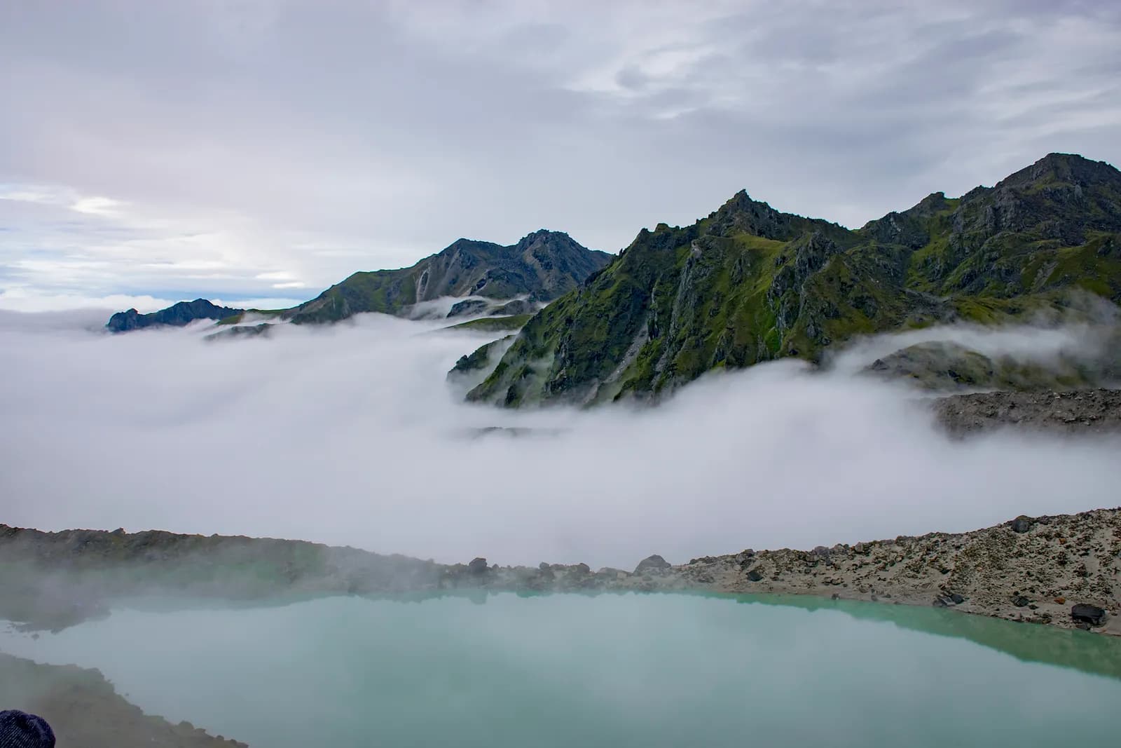
Dudh Kunda Trek
A six-day trek from Ringmu in Solu over Taksindu to Sano Beni and the sacred lake of Dudh Kunda at about 4,560 m below Numbur Himal, with a road start and finish.
- ימים6
- גובה מרבי4,561 מ'
- מרחק37.7 ק"מ
- עלייה2,439 מ'
- קושיקשה
- החודשים הטובים ביותרMar–May, Sep–Nov
- היתרים3
תמונה: Chandra Chakradhar · CC BY-SA 4.0
מוצג באנגלית — טרם תורגם.
המסלול הזה הוא טיוטה וטרם אומת. תמיד אמתו את השלבים עם המדריך שלכם.
Written by FindTrekkingPartner teamנבדק על ידי FindTrekkingPartner teamאיך אנחנו בודקיםFindTrekkingPartner
Dudh Kunda Trek הוא טרק של 6 ימים באזור Solu בנפאל, שמטפס עד 4,561 מ'. מטיילים זרים יכולים למצוא לו שותף ב-FindTrekkingPartner בפרסום טיול עם התאריכים, התקציב והקצב שלהם. ההתאמות נשארות פרטיות עד ששני המטיילים מסכימים, והשירות חינמי. במחירי טווח הביניים מדריך מורשה עולה כ-56 דולר ארה״ב לאדם על פני 6 ימים כשארבעה מטיילים חולקים, לעומת 224 דולר ארה״ב למטייל יחיד. העונות הטובות ביותר הן Mar–May, Sep–Nov. בפועל נדרש כאן מדריך מורשה: לפי דיווחי מפעילים מ-2026, כלל מועצת התיירות של נפאל מאפריל 2023 נאכף במחסומים בפארקים לאומיים ובאזורי שימור, כשלנגטנג היא המחמירה ביותר ואנאפורנה בודקת גם היא (נבדק ב-19 באוקטובר 2026). שכרו מדריך דרך סוכנות רשומה ואשרו מולה. טיולים פתוחים למסלול זה מופיעים למטה, עם חודש יציאה, גודל קבוצה ומקומות פנויים. אומת לאחרונה: 19 באוקטובר 2026. מקורות: מועצת התיירות של נפאל, DNPWC, מחלקת ההגירה.
מקורות:Department of Immigration, NepalNepal Tourism BoardDepartment of National Parks and Wildlife Conservation
מצאו שותף לDudh Kunda Trek
- מצאו שותף לDudh Kunda Trekעדיין אין טיולים פתוחים
- מצאו שותף לPikey Peak Trekעדיין אין טיולים פתוחים
סקירה
יוצא מ-Kathmandu6 ימים · עד 4,561 מ'
העונות הטובות ביותר: Mar–May, Sep–Nov · היתרים: No restricted-area permit, Outside Sagarmatha National Park, Ask your agency about any local trek card
The Dudh Kunda trek is a six-day walk from the village of Ringmu, above Salleri in Solukhumbu, to a high glacial lake at about 4,560 m under Numbur Himal that is sacred to Hindus and Buddhists. A jeep takes you from Kathmandu to Ringmu in about ten to eleven hours, the trail climbs through Taksindu to the inn at Sano Beni at about 4,000 m, and a day trip reaches the lake and returns. The walk back to Ringmu and a drive to Kathmandu finish the trip. It covers about 38 km with 2,440 m of climbing, and it is harder than the distances suggest, because two nights are at about 4,000 m and the stage from Taksindu to Sano Beni climbs 1,300 m. It needs no flight and no restricted-area permit, and warm clothing and a good sleeping bag matter more than technical gear.
The plan follows the Kathmandu Post's account of its Dudh Kunda walk, which uses the same stops, and an operator's day-by-day notes that route through Taksindu and Sano Beni; Alpine Adventure Club sells a longer cultural trail through Taksindu and Nunthala. Lodging is thin at Sano Beni, and the Post's writer found only a roughly built house, so carry a good sleeping bag, check with your agency, and allow time to acclimatise. The best months are March to May and September to November, and pilgrims come in the August full-moon week.
Difficulty and fitness
The trek is hard for its length. Sano Beni and the lake are at about 4,000 m and 4,560 m, you sleep at 4,000 m on two nights, and the climb from Taksindu is about 1,300 m in one day. It suits fit trekkers who have spent time above 3,500 m before, and the rest day at Sano Beni is part of the acclimatisation, not a spare day.
Budget notes
The Kathmandu Post gives NPR 13,000 per person for its own trip. Our estimate on the costs section uses Nepal-wide lodge and meal ranges with a guide, a porter and road transport, and shows the jeep fare as a line to check. Allow for a good sleeping bag and for a guide who knows the Taksindu to Sano Beni ridge.
What to pack
A warm sleeping bag rated well below freezing, a down jacket, gloves, a hat, waterproofs, a headlamp and snacks. Do not rely on finding food or rooms at Sano Beni without confirming first.
נקודות עיקריות
- Dudh Kunda, a pilgrimage lake at about 4,560 m below Numbur Himal
- The Kamidanda viewpoint, with Everest and Kanchenjunga on a clear day
- Taksindu monastery and the Taksindu La kani gate
- Quiet trails, with almost no other trekkers outside August
- A pilgrim festival in the full-moon week of August
מפת מסלול
נתוני המסלול מ-OpenStreetMap ועדיין לא נבדקו על ידי הצוות שלנו. השתמשו בהם לתכנון, לא לניווט.
יום אחר יום
A short walk of about 2.2 km and 250 m, one to two hours by our estimate, takes you from Ringmu to Taksindu, at about 2,925 m, along a marked path with views back to the valley. Taksindu has a Sherpa monastery below Taksindu La, a pass at about 3,070 m on OpenStreetMap, where a Buddhist gate stands. Visit the monastery and the pass in the afternoon. The easy day is deliberate: tomorrow is long and climbs a long way, so rest, drink water and sleep as well as you can.
A long day of about 12 km and 1,310 m of climbing, seven to eight hours by our estimate, leads from Taksindu to Sano Beni. The path is marked, with rhododendron forest below and open pasture above, and the operator notes mention the Kamu Dada hotel and Aakhey Pokhari lakes as stops. Sano Beni is at about 4,010 m on the elevation model, and the inn there is basic. The Post's writer found lodging a hardship, so confirm your arrangements first. You gain a great deal of altitude today, so go slowly and watch for headache.
A day out and back from Sano Beni to Dudh Kunda: about 10.5 km round trip, with 660 m of climbing and descent, six to seven hours in all. The Post's writer climbed for about three hours to reach the lake at 4,561 m under Numbur Himal, which is held sacred, and returned to Sano Beni the same day. The weather often turns, so start early and turn back if it does. Walk quietly, do not disturb offerings, and avoid swimming. The night at Sano Beni gives you a second night at about 4,000 m before you descend.
A downhill day of about 12.8 km, 1,410 m of descent, five to six hours by our estimate, takes you from Sano Beni back along the ridge to Taksindu and on to Ringmu. The air thickens and the forest returns as you descend, and your knees will feel the drop. Kamidanda, the viewpoint above Ringmu, shows Everest and Kanchenjunga on a clear day, according to the Post, and new homestays were being built there. The hotel at Ringmu feels luxurious after Sano Beni.
Drive from Ringmu to Kathmandu, about an hour to Salleri and ten hours onward, according to the Post and Nepal Traveller, who give eight to twelve hours depending on conditions. Leave early, because daylight matters on the mountain road. Bring snacks, and allow a spare day before an international flight, as landslides can close the road. If you are connecting to a flight, you may prefer to fly from Phaplu, but flights depend on weather.
כמה זה עולה
עלות משוערת הכול כלול לאדם: לינה ואוכל לפי גובה, תחבורה, היתרים, מדריך וסבלים. ככל שיותר מטיילים חולקים מדריך וסבלים, כל אחד משלם פחות. נכון ל-אוקטובר 2026.
| סגנון | מטייל 1 | 2 מטיילים שחולקים עלויות | 4 מטיילים שחולקים עלויות |
|---|---|---|---|
| חסכוני | 130 $–210 $* | 130 $–210 $* | 130 $–210 $* |
| בינוני | 390 $–600 $* | 280 $–440 $* | 240 $–380 $* |
| נוחות | 440 $–670 $* | 370 $–560 $* | 330 $–510 $* |
חלקו מדריך, חסכו כסף
בטווח הבינוני, מטייל יחיד משלם כ-390 $–600 $; ארבעה מטיילים שחולקים מדריך אחד ושני סבלים משלמים כ-240 $–380 $ כל אחד (37% פחות בקצה העליון של הטווח).
פירוט ל-2 מטיילים שחולקים עלויות
| פריט | חסכוני | בינוני | נוחות |
|---|---|---|---|
| לינה ואוכל | 130 $–210 $ | 170 $–280 $ | 230 $–350 $ |
| מדריך | — | 70 $–120 $ | 70 $–120 $ |
| סבלים | — | 30 $–60 $ | 60 $–110 $ |
תקציבי משתמש בתחבורה ציבורית וללא סבל; בינוני חולק סבל אחד בין שני מטיילים ורכב פרטי; נוח נותן לכל מטייל סבל. מדריך כלול כשהוא נדרש או כשהסגנון בינוני או נוח.
לינה ואוכל ללילה (חדר וארוחת דאל בהט)
3 לילות 2,500 to 3,800 m: חדר 4 $–11 $, דאל בהט 5 $–11 $ · 2 לילות Above 3,800 m: חדר 7 $–19 $, דאל בהט 8 $–13 $
לא כלול
לא נמצא מחיר מפורסם עבור: Kathmandu to Ringmu by road (return). סכומים המסומנים ב-* אינם כוללים אותם; שאלו את הסוכנות. Lodging at Sano Beni is thin, so confirm rooms or carry tents. The Kathmandu Post gives NPR 13,000 per person for its own five-day trip.
מקורות העלויות
- PriceNepal: Nepal Travel Cost Guide 2026 (2026-05-14)
- Third Rock Adventures: Nepal trek budget planner (2026-05-09)
- Himalayan Partner: Guide and porter price in Nepal 2026 (2026-02-10)
- Shikhar Adventure: Annapurna Circuit trek cost (2026-02-03)
- Nepal Tourism Board: Trekking Permit (2026-10-18)
הערכות ממדריכי מפעילים, לא הצעות מחיר. תשר, ביטוח, ציוד ומלונות בקטמנדו אינם כלולים; USD לפי שער ההמרה של הפלטפורמה.
תמונות
שאלות נפוצות
This plan takes six days from Kathmandu to Kathmandu, with three days of walking up and one day of walking down plus a lake day. The Kathmandu Post describes a five-day trip, and operator plans range from seven to sixteen days with Pikey, Junbesi and Nunthala added.
The Kathmandu Post gives 4,561 m, and our elevation model gives about 4,630 m, so we quote about 4,560 m. The inn at Sano Beni, where you sleep, is at about 4,000 m.
No. There is another Dudhkunda in the Gaurishankar area of Dolakha, which is a different lake. This route goes to the one in Solukhumbu, below Numbur Himal.
In the full-moon week of August, according to the Kathmandu Post, when locals and pilgrims gather at the lake. At other times you are unlikely to meet anyone there, but the weather is wet in August.
No restricted-area permit is needed. The route is outside Sagarmatha National Park, so its entry permit does not apply. Ask your agency whether the local municipality collects a fee.
מקורות
לאורך השביל
לינה, סיוע רפואי, מים ונקודות עניין בכל יום של המסלול.
1. Kathmandu → Ringmu
- Tribhuvan International Airport · שדות תעופה ותחבורה · 1,340 מ'
2. Ringmu → Taksindu
- Hotel Yak&Nak · לינה · 2,770 מ'
- Quite view · לינה · 2,835 מ'
- Taksindu Lodge · לינה · 2,945 מ'
- Takassindu Resort · לינה · 2,900 מ'
Show all 5 places
- Hotel Yak&Nak · לינה · 2,770 מ'
- Quite view · לינה · 2,835 מ'
- Hiltop Guest House · לינה · 3,070 מ'
- Taksindu Lodge · לינה · 2,945 מ'
- Takassindu Resort · לינה · 2,900 מ'
3. Taksindu → Sano Beni
- Mountain View Lodge · לינה · 2,908 מ'
- Panorama Guest House · לינה · 2,946 מ'
- Lodges · לינה · 2,962 מ'
- Taksindu La · טבע · 3,071 מ'
4. Sano Beni
- Numbur Guest House · לינה · 4,022 מ'
- Dudhkunda · טבע · 4,606 מ'
5. Sano Beni → Ringmu
- Viewpoint · נקודות תצפית · 3,073 מ'
- Sherpa Fast Food Lodge · לינה · 2,848 מ'
6. Ringmu → Kathmandu
עדיין לא מופה דבר ליום הזה.עדיין לא מופה דבר ליום הזה.
אומת לאחרונה ב-19 באוק׳ 2026דיווח על מידע לא עדכני