

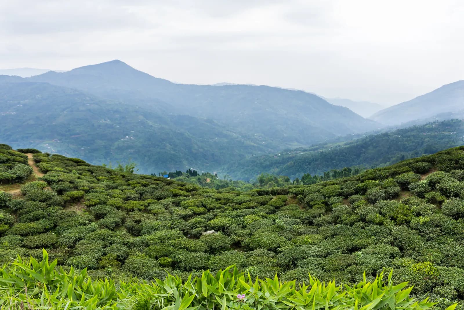
Reach Kanyam by taxi or bus and start early, when the air over the tea is clear. The mapped lanes run down through the estates to Fikkal, 5.3 km with about 150 m of descent and almost all on tea-estate and village roads, so allow 1.5 to 2 hours with stops. Kanyam sits at about 1,800 m by one source, with a 240 ha garden, and an operator suggests a factory visit before you leave. Fikkal is the commercial centre of the area, with a weekly haat on Thursdays, hotels and shops, and it is the base for the Antu Danda walk the next day.
Ilam Tea Gardens and Antu Danda
A three-day walk in Ilam's tea country: down through the Kanyam estates to Fikkal, then 16.7 km to the Antu Danda watchtower for a sunrise over Kanchenjunga, Makalu and Everest, with no permit.
- ימים3
- גובה מרבי2,328 מ'
- מרחק38.8 ק"מ
- עלייה1,315 מ'
- קושיקל
- החודשים הטובים ביותרMar–Jun, Sep–Nov
תמונה: Bijay chaurasia · CC BY-SA 4.0
מוצג באנגלית — טרם תורגם.
המסלול הזה הוא טיוטה וטרם אומת. תמיד אמתו את השלבים עם המדריך שלכם.
Written by FindTrekkingPartner teamנבדק על ידי FindTrekkingPartner teamאיך אנחנו בודקיםFindTrekkingPartner
Ilam Tea Gardens and Antu Danda הוא טרק של 3 ימים באזור Ilam בנפאל, שמטפס עד 2,328 מ'. מטיילים זרים יכולים למצוא לו שותף ב-FindTrekkingPartner בפרסום טיול עם התאריכים, התקציב והקצב שלהם. ההתאמות נשארות פרטיות עד ששני המטיילים מסכימים, והשירות חינמי. במחירי טווח הביניים מדריך מורשה עולה כ-28 דולר ארה״ב לאדם על פני 3 ימים כשארבעה מטיילים חולקים, לעומת 112 דולר ארה״ב למטייל יחיד. העונות הטובות ביותר הן Mar–Jun, Sep–Nov. מדריך מורשה אינו נאכף במסלולים פתוחים כמו זה (נבדק ב-19 באוקטובר 2026): עיריית חומבו פרשה מכלל מועצת התיירות של נפאל מאפריל 2023, וטיולי יום אינם דורשים מדריך, אבל מומלץ מאוד לקחת מדריך בכל זאת, לכן אשרו מול הסוכנות. טיולים פתוחים למסלול זה מופיעים למטה, עם חודש יציאה, גודל קבוצה ומקומות פנויים. אומת לאחרונה: 19 באוקטובר 2026. מקורות: מועצת התיירות של נפאל, DNPWC, מחלקת ההגירה.
מקורות:Department of Immigration, NepalNepal Tourism BoardDepartment of National Parks and Wildlife Conservation
מצאו שותף לIlam Tea Gardens and Antu Danda
- מצאו שותף לIlam Tea Gardens and Antu Dandaטיול פתוח אחד
סקירה
יוצא מ-Kanyam3 ימים · עד 2,328 מ'
העונות הטובות ביותר: Mar–Jun, Sep–Nov
The Ilam Tea Gardens and Antu Danda trek is a three-day walk through the tea country of eastern Nepal: a morning down through the Kanyam estates to Fikkal, then the road walk from Fikkal to the Antu Danda watchtower (about 2,000 m), a night near the viewpoint, and the return at sunrise. On our map the three days are 5.3 km, 16.7 km and 16.7 km, with about 610 m of climbing on the two long days, and almost all of it on village roads and tea-estate lanes. An operator gives 11 km and 3 to 4 hours up and 5 to 6 hours back, so we allow 4 to 6 hours each way. No permit, no flight inside the route and no altitude are involved, and the best months are March to June and September to November.
What the walk is like
Day one is a gentle descent from Kanyam, the best-known tea garden in the district, to the bazaar town of Fikkal. Day two follows village roads east to Shree Antu, past tea, cardamom and forest, and ends at Antu Danda, where you sleep close to the watchtower. Day three starts before dawn for the view of Kanchenjunga, Makalu and Everest, then returns to Fikkal by the same road or by a vehicle from Shree Antu. The walking is easy but long, mostly on roads, so it suits people who like to take the days slowly.
Day by day
Day one is 5.3 km down from Kanyam to Fikkal, 1.5 to 2 hours, mostly on tea-estate roads. Day two is the long walk to Antu Danda, 16.7 km on our map and 4 to 6 hours with stops, sleeping close to the watchtower. Day three is the sunrise and the return to Fikkal, another 16.7 km, with the option of a vehicle from Shree Antu. Mai Pokhari is not on the walking route, since it lies in a different part of the district, but it makes an easy extra morning if you have a vehicle.
Getting there and away
Most visitors fly to Bhadrapur or Chandragadhi in Jhapa and drive north to Fikkal, which is about 700 km from Kathmandu by road. Kanyam is a short ride from Fikkal. A vehicle can pick you up from Shree Antu on day two or three.
Permits, guides and costs
No trekking permit or TIMS card is needed, and Ilam lies outside any national park, conservation area or restricted area, so no guide is required; one is optional. Costs are two nights of lodging, the transfers and any guide; see the cost section for ranges.
Season and safety
Spring and autumn are best, and autumn is clearest for the Himalayan view. The roads are muddy in the monsoon and mist can hide the sunrise, so build in a spare morning. See our guide rule page for the rule in full.
נקודות עיקריות
- Kanyam, the best-known tea garden of Ilam, with long views over the estates
- Fikkal bazaar and its Thursday haat
- Sunrise from the Antu Danda watchtower over Kanchenjunga, Makalu and Everest
- Easy walking on village roads with no permit and no altitude
- Mai Pokhari, a Ramsar-listed lake, as a drive from Ilam Bazaar
מפת מסלול
נתוני המסלול מ-OpenStreetMap ועדיין לא נבדקו על ידי הצוות שלנו. השתמשו בהם לתכנון, לא לניווט.
יום אחר יום
Walk east from Fikkal on village roads through tea gardens, cardamom fields and patches of forest to Shree Antu and the Antu Danda hill. One operator gives 11 km and 3 to 4 hours for this walk; the road we mapped is 16.7 km with about 610 m of climbing and a similar amount of descent, so we allow 4 to 6 hours with stops for tea. Mist and heat can both build by afternoon, so start early and carry water. A homestay near the viewpoint puts you a short walk from the watchtower for tomorrow's sunrise, with the hills of Darjeeling on the horizon on a clear evening.
Climb the watchtower before dawn: an operator lists Kanchenjunga (8,586 m), Makalu (8,463 m) and Everest (8,848 m) from here on a clear morning. After breakfast, walk back to Fikkal on the same roads, 16.7 km on our map, which the same operator gives as 5 to 6 hours. If your legs are tired, a vehicle can meet you at Shree Antu, and a drive of about 1 hour to Pashupatinagar or about 3 hours to Ilam Bazaar takes you on towards Mai Pokhari or the airport.
כמה זה עולה
עלות משוערת הכול כלול לאדם: לינה ואוכל לפי גובה, תחבורה, היתרים, מדריך וסבלים. ככל שיותר מטיילים חולקים מדריך וסבלים, כל אחד משלם פחות. נכון ל-אוקטובר 2026.
| סגנון | מטייל 1 | 2 מטיילים שחולקים עלויות | 4 מטיילים שחולקים עלויות |
|---|---|---|---|
| חסכוני | 30 $–60 $* | 30 $–60 $* | 30 $–60 $* |
| בינוני | 170 $–290 $* | 110 $–180 $* | 80 $–150 $* |
| נוחות | 190 $–310 $* | 150 $–240 $* | 120 $–210 $* |
חלקו מדריך, חסכו כסף
בטווח הבינוני, מטייל יחיד משלם כ-170 $–290 $; ארבעה מטיילים שחולקים מדריך אחד ושני סבלים משלמים כ-80 $–150 $ כל אחד (49% פחות בקצה העליון של הטווח).
פירוט ל-2 מטיילים שחולקים עלויות
| פריט | חסכוני | בינוני | נוחות |
|---|---|---|---|
| לינה ואוכל | 30 $–60 $ | 40 $–80 $ | 50 $–100 $ |
| מדריך | — | 40 $–70 $ | 40 $–70 $ |
| סבלים | — | 20 $–40 $ | 40 $–80 $ |
תקציבי משתמש בתחבורה ציבורית וללא סבל; בינוני חולק סבל אחד בין שני מטיילים ורכב פרטי; נוח נותן לכל מטייל סבל. מדריך כלול כשהוא נדרש או כשהסגנון בינוני או נוח.
לינה ואוכל ללילה (חדר וארוחת דאל בהט)
2 לילות Below 2,500 m: חדר 2 $–9 $, דאל בהט 4 $–7 $
לא כלול
לא נמצא מחיר מפורסם עבור: Fikkal to Kanyam by taxi or bus; Antu Danda back to Fikkal by vehicle (optional). סכומים המסומנים ב-* אינם כוללים אותם; שאלו את הסוכנות. A lodge-based walk with no permit: the costs are two nights, meals and transfers. A guide is optional.
מקורות העלויות
- PriceNepal: Nepal Travel Cost Guide 2026 (2026-05-14)
- Third Rock Adventures: Nepal trek budget planner (2026-05-09)
- Himalayan Partner: Guide and porter price in Nepal 2026 (2026-02-10)
- Shikhar Adventure: Annapurna Circuit trek cost (2026-02-03)
- Nepal Tourism Board: Trekking Permit (2026-10-18)
הערכות ממדריכי מפעילים, לא הצעות מחיר. תשר, ביטוח, ציוד ומלונות בקטמנדו אינם כלולים; USD לפי שער ההמרה של הפלטפורמה.
תמונות
שאלות נפוצות
An operator gives 11 km and 3 to 4 hours up, and 5 to 6 hours back. Our map follows village roads for 16.7 km, so we allow 4 to 6 hours each way.
Yes, by vehicle: sources give about 3 hours from Ilam Bazaar and about 1 hour from Pashupatinagar. Sleeping near the viewpoint is better for the sunrise.
An operator lists Kanchenjunga, Makalu and Everest at sunrise, and the hills of Darjeeling on a clear day.
Yes. It is the best known tea garden in Ilam, with a 240 ha estate and a factory that operators include in tours, and it is a short ride from Fikkal.
March to June and September to November. Autumn has the clearest air, and the monsoon brings cloud and mud.
מקורות
לאורך השביל
לינה, סיוע רפואי, מים ונקודות עניין בכל יום של המסלול.
1. Kanyam → Fikkal
- Viewpoint · נקודות תצפית · 1,644 מ'
- Kanyum cottage village · לינה · 1,604 מ'
- Phikkal Hospital · רפואה · 1,562 מ'
- Hotel Shikher · לינה · 1,579 מ'
- Hotel Bishal · לינה · 1,561 מ'
- Hotel Sonam · לינה · 1,556 מ'
Show all 10 places
- Viewpoint · נקודות תצפית · 1,644 מ'
- Kanyum cottage village · לינה · 1,604 מ'
- Kharel hotel and Lodge · לינה · 1,548 מ'
- Rinchhen Hotel and Lodge · לינה · 1,546 מ'
- Rinchen Hotel & lodge · לינה · 1,541 מ'
- Sun Hotel and Lodge · לינה · 1,544 מ'
- Phikkal Hospital · רפואה · 1,562 מ'
- Hotel Shikher · לינה · 1,579 מ'
- Hotel Bishal · לינה · 1,561 מ'
- Hotel Sonam · לינה · 1,556 מ'
2. Fikkal → Antu Danda
- Hotel Snow View · לינה · 1,641 מ'
- Shri Antu Pharmacy · רפואה · 1,644 מ'
- ABC Homestay · לינה · 1,643 מ'
- Kaijen Hotel · לינה · 1,642 מ'
- Kausal Homestay · לינה · 1,694 מ'
Show all 6 places
- Hotel Snow View · לינה · 1,641 מ'
- Shri Antu Pharmacy · רפואה · 1,644 מ'
- ABC Homestay · לינה · 1,643 מ'
- Kaijen Hotel · לינה · 1,642 מ'
- Kausal Homestay · לינה · 1,694 מ'
- Khadka Homestay · לינה · 1,703 מ'
3. Antu Danda → Fikkal
- Antu Hill · נקודות תצפית · 1,824 מ'
- Antu Lake · טבע · 1,658 מ'
- Hotel Elite · לינה · 1,575 מ'
- Lodge · לינה · 1,560 מ'
- Hotel Dawa · לינה · 1,559 מ'
- Pathivara poly clinic · רפואה · 1,576 מ'
- Hotel Mandala · לינה · 1,564 מ'
Show all 11 places
- Antu Hill · נקודות תצפית · 1,824 מ'
- Pradhan Homestay · לינה · 1,684 מ'
- Misara Homestay · לינה · 1,694 מ'
- Ghimire Homestay · לינה · 1,643 מ'
- Antu Lake · טבע · 1,658 מ'
- Antu Homestay · לינה · 1,662 מ'
- Hotel Elite · לינה · 1,575 מ'
- Lodge · לינה · 1,560 מ'
- Hotel Dawa · לינה · 1,559 מ'
- Pathivara poly clinic · רפואה · 1,576 מ'
- Hotel Mandala · לינה · 1,564 מ'
אומת לאחרונה ב-19 באוק׳ 2026דיווח על מידע לא עדכני