

Drive from Kathmandu east to Charikot and Singati, then north along the Tamakoshi and Rolwaling rivers to Chetchet, the roadhead at about 1,410 m. The drive takes 8 to 9 hours in a jeep, with a rough, muddy last stretch, passing terraced hills, small bazaars and views of the Gauri Shankar range on a clear day. The road is often blocked by landslides in the monsoon, so keep a spare day. Chetchet is a small village with simple lodges, and you spend the night here.
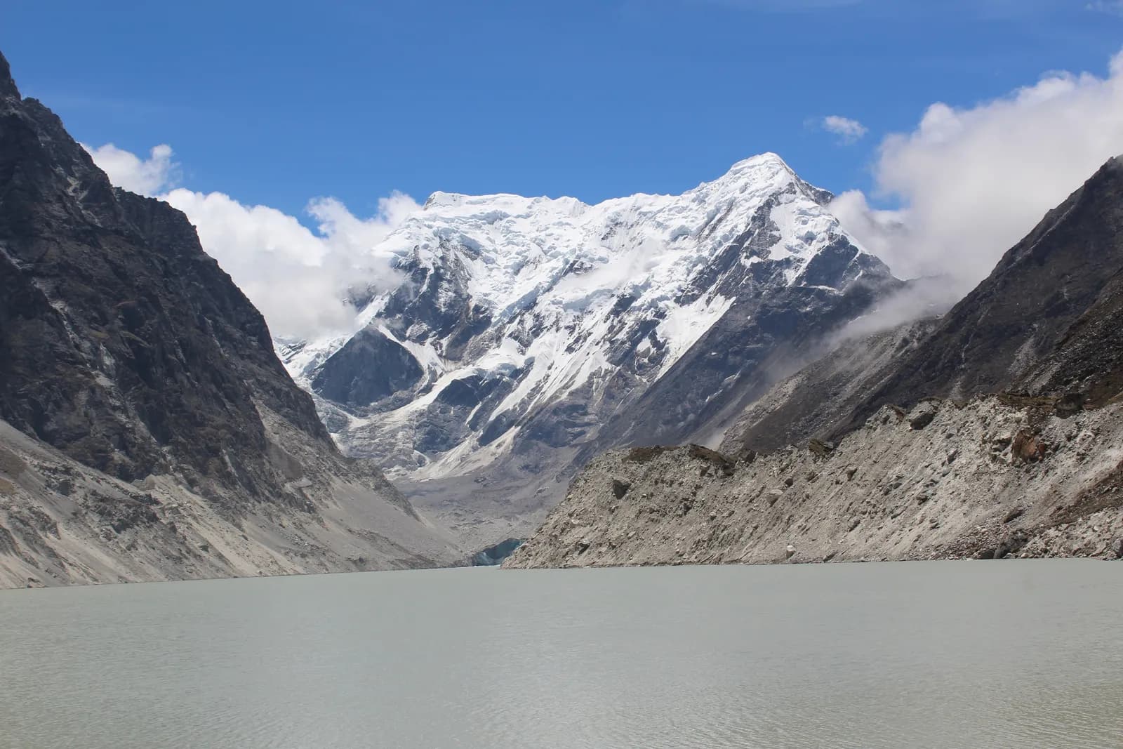
Rolwaling and Tsho Rolpa Trek
An 11-day road-access trek up the Rolwaling valley from Chetchet through Simigaon, Dongang, Beding and Na to Tsho Rolpa, a glacial lake at about 4,580 m under Gaurishankar.
- روز11
- بیشینه ارتفاع۴٬۵۸۰ متر
- مسافت۶۴٫۲ کیلومتر
- صعود۳٬۸۴۷ متر
- دشواریسخت
- بهترین ماههاMar–May, Oct–Nov
- مجوزها2
با این برنامه سفر بسازیدبرای Rolwaling and Tsho Rolpa Trek همراه پیدا کنیدمشاهده حرکتها بر اساس هفته
عکس: Hrishav398 · CC BY-SA 4.0
به انگلیسی نمایش داده میشود — هنوز ترجمه نشده است.
این برنامهٔ سفر پیشنویس است و هنوز بررسی نشده. همیشه مراحل را با راهنمای خود تأیید کنید.
Written by FindTrekkingPartner teamبررسیشده توسط FindTrekkingPartner teamروش بررسی ماFindTrekkingPartner
Rolwaling and Tsho Rolpa Trek یک مسیر پیادهروی 11 روزه در منطقه Rolwaling نپال است که تا ۴٬۵۸۰ متر بالا میرود. پیادهروهای خارجی میتوانند در FindTrekkingPartner با ثبت یک سفر همراه با تاریخ، بودجه و سرعت خود، برای آن همسفر پیدا کنند. تا زمانی که هر دو پیادهرو موافقت نکنند، تطابقها خصوصی میمانند و این سرویس رایگان است. با نرخهای متوسط، یک راهنمای دارای مجوز وقتی چهار پیادهرو سهم میدهند حدود ۹۰ دلار آمریکا (USD) برای هر نفر در 11 روز هزینه دارد، در مقابل ۳۶۱ دلار آمریکا (USD) برای یک پیادهرو بهتنهایی. بهترین فصلها Mar–May, Oct–Nov هستند. در عمل در اینجا راهنمای دارای مجوز لازم است: بر اساس گزارشهای فعالان تور در 2026، قانون آوریل 2023 هیئت گردشگری نپال در ایستهای بازرسی پارکهای ملی و مناطق حفاظتشده اجرا میشود؛ لانگتانگ سختگیرترین است و آناپورنا نیز بازرسی میکند (بررسیشده در 19 اکتبر 2026). راهنما را از طریق یک آژانس ثبتشده بگیرید و با آنها تأیید کنید. آخرین بررسی: ۲۷ مهر ۱۴۰۵. منابع: هیئت گردشگری نپال، DNPWC، اداره مهاجرت.
منابع:Department of Immigration, NepalNepal Tourism BoardDepartment of National Parks and Wildlife Conservation
یافتن همسفر برای Rolwaling and Tsho Rolpa Trek
- یافتن همسفر برای Rolwaling and Tsho Rolpa Trekهنوز سفر بازی نیست
نمای کلی
شروع از Kathmandu۱۱ روز · حداکثر ۴٬۵۸۰ متر
بهترین فصلها: Mar–May, Oct–Nov · مجوزها: Gaurishankar Conservation Area entry permit, TIMS card where required
The Rolwaling and Tsho Rolpa trek is an 11-day journey up a hidden Sherpa valley in Dolakha District, east of Langtang, to one of Nepal's largest glacial lakes at about 4,580 m. It drives from Kathmandu to Chetchet in a day, climbs to Simigaon, Dongang and Beding, rests at Beding, continues to Na for a day trip to Tsho Rolpa under the pyramid of Gaurishankar, 7,134 m, and returns by the same trail before the drive back. The route covers about 64 km on foot, with about 3,850 m of climbing, and sleeps up to about 4,190 m at Na. The valley lies in the Gaurishankar Conservation Area, so you need the conservation area permit and and a guide is strongly advised, but no restricted-area permit. The trek is hard because of steep trails and altitude, and the best months are October and November, and March to May. It suits fit trekkers who want a quiet valley close to Kathmandu.
What the trek is like
The trail starts above the Tamakoshi and Rolwaling rivers at Chetchet, then climbs steeply through terraces and forest to Simigaon, the first Sherpa village. From there it follows the Rolwaling Khola through rhododendron, oak and fir forest, crossing the river on bridges, to Dongang and then up to Beding, a village of stone houses and yak pastures on an open terrace. Above Beding the valley widens into meadows and moraine, and Na is a seasonal settlement at the foot of the lake trail. The lake itself sits behind a moraine dam, with the glacier and the peaks of the Rolwaling Himal behind it.
Highlights
- Tsho Rolpa, a glacial lake about 4,580 m high in the Rolwaling Valley
- Views of Gaurishankar, Menlungtse and the Rolwaling Himal from Beding and Na
- Simigaon and Beding, Sherpa villages with gompas and mani walls
- Rhododendron and fir forest, with chances of red panda and Himalayan tahr
- A trek that starts and ends with a road drive, with no flights
Permits and rules
You need a Gaurishankar Conservation Area entry permit, bought through your agency or at the checkpoint, and a TIMS card where the local office asks for it. Rolwaling is not a restricted area. The Nepal Tourism Board April 2023 rule requires foreign trekkers to use a licensed guide in national parks and conservation areas, and 2026 operator reports say checkpoints enforce it in Annapurna (ACAP), Langtang (the strictest) and most other parks, but not in Khumbu, where the municipality opted out (checked 19 October 2026). See the guide rule by region. Fees differ for foreigners, SAARC nationals and Nepalis, so ask for current amounts and check them with the National Trust for Nature Conservation or the Department of National Parks and Wildlife Conservation.
Best season
October and November are the best months, with stable weather and clear views. March to May bring rhododendron, though snow can linger above Beding early in spring. The monsoon has leeches, landslides and cloud, and December to February are very cold with snow above Dongang. Allow a spare day for the road.
Altitude
The plan climbs from Chetchet at about 1,410 m to Simigaon (about 1,970 m), Dongang (about 2,790 m) and Beding (about 3,710 m), then to Na (about 4,190 m), with a rest day at Beding and a day trip to the lake at about 4,580 m. The gain from Dongang to Beding is about 1,050 m in one day, so go slowly. Watch for headache, nausea and poor sleep, never ascend with symptoms, and descend if they worsen. Discuss altitude medicine with your doctor.
Getting there and away
Drive from Kathmandu via Charikot and Singati to Chetchet, about 8 to 9 hours in a jeep, with a rough last section. The road is prone to landslides in the monsoon, and in some years it ends at Singati, adding days. The return is the same drive on the last day. There are no flights, and a spare day for the road is wise.
Lodges, food and costs
Simple lodges and homestays operate at Chetchet, Simigaon, Dongang, Beding and Na, with dal bhat, noodles, potatoes and tea. Rooms are basic, with blankets, and during busy periods some groups camp at Na. Prices rise with altitude, and you should bring cash for the whole trek, because there are no machines beyond Charikot.
Packing list
Broken-in boots, waterproof layers, a down jacket, a sleeping bag rated to about minus 10 to minus 15 C, gloves, hat, sunglasses, sun cream, trekking poles, a headlamp, water purification and a first-aid kit. In the monsoon, add leech socks and a rain cover.
Who this trek suits and how to prepare
The trek suits fit trekkers who want a remote valley without flights. The climbs are steep, and the descent from Beding to Simigaon is a long day of about 19 km, so prepare with hill walks, stair training and some days with a loaded pack.
The plan at a glance
Day 1 drives to Chetchet. Days 2 to 4 walk to Simigaon, Dongang and Beding, with a rest day on day 5. Day 6 walks to Na and day 7 is the day trip to Tsho Rolpa. Days 8 to 10 return to Beding, Simigaon and Chetchet, and day 11 drives to Kathmandu.
Extensions
Add a day at Na for a walk toward Yalung Ri or a day in Simigaon for weather. Experienced trekkers with a specialist agency can cross the Tashi Lapcha, at about 5,755 m, to Thame in the Everest region, which needs technical equipment and the right permits. Others combine Rolwaling with the Everest region by road.
Practical tips from the trail
- Walking times in the day plan are estimates from distance and climb, checked against operator itineraries; real times differ with pace, load and weather.
- Go to the lake early, when the air is clear and the winds are light.
- Use poles on the long descent from Beding to Simigaon.
- Keep a warm layer and a waterproof jacket in your day bag.
- Do not camp on the dam, and follow your guide's advice near the lake.
- Book the return jeep in advance, since few vehicles wait at Chetchet.
Responsible trekking
Take rubbish out, do not swim or camp at the lake, walk clockwise around mani walls, buy from local lodges and ask before photographing people.
نکات برجسته
- Tsho Rolpa, one of the biggest glacial lakes in Nepal, at about 4,580 m
- Gaurishankar (7,134 m) and the Rolwaling Himal
- Sherpa villages at Simigaon, Beding and Na
- Rhododendron and fir forest in the Gaurishankar Conservation Area
- A quiet valley reached by road in a day
نقشه مسیر
دادههای مسیر از OpenStreetMap است و هنوز تیم ما آن را بررسی نکرده است. برای برنامهریزی استفاده کنید، نه مسیریابی.
روزبهروز
شما ۵۶۰ متر بالاتر از شب قبل میخوابید، بیش از حد معمول ۵۰۰ متر. آهسته بروید، زیاد آب بنوشید و مراقب سردرد یا تهوع باشید.
A short walking day from Chetchet to Simigaon at about 1,970 m, about 2 km but with a steep climb of nearly 600 m, taking 2 to 3 hours. The path climbs through terraces, forest and stone steps to the first Sherpa village of the valley, with a gompa, mani walls and potato fields. Simigaon has simple lodges and good views up the valley. Use the afternoon to rest, drink water and prepare for tomorrow's longer day. The air is cool and the village is quiet.
شما ۸۲۰ متر بالاتر از شب قبل میخوابید، بیش از حد معمول ۵۰۰ متر. آهسته بروید، زیاد آب بنوشید و مراقب سردرد یا تهوع باشید.
Walk from Simigaon to Dongang at about 2,790 m, about 9 km with a climb of 1,010 m, taking 4.5 to 6 hours. The trail follows the Rolwaling Khola through rhododendron, oak and fir forest, crossing the river on bridges and passing small waterfalls. Dongang is a forest clearing with a few lodges and the base for the climb to Beding. The air cools and views open. Rest, eat well and keep warm layers handy, because temperatures fall quickly in the evening.
شما ۹۲۰ متر بالاتر از شب قبل میخوابید، بیش از حد معمول ۵۰۰ متر. آهسته بروید، زیاد آب بنوشید و مراقب سردرد یا تهوع باشید.
A steady climb from Dongang to Beding at about 3,710 m, about 10 km with a climb of 1,050 m, taking 5 to 6 hours. The valley opens as you leave the forest and enter meadows and moraine, with views of Gaurishankar and the Rolwaling Himal ahead. Beding is the main Sherpa village of the upper valley, with stone houses, a gompa, mani walls and yak herds. Settle in, watch for symptoms of altitude sickness and drink plenty of water. Tomorrow is a rest day.
A rest and acclimatisation day at Beding. Visit the gompa, walk around the village and take an easy hike up the meadows above the houses for views of Gaurishankar and the valley, returning by the afternoon. The aim is to sleep at the same height as the day before, and to let your body adapt. Drink water, eat well and talk to your guide about the route and weather. Use the afternoon to dry gear and charge power banks if the lodge has solar power.
Walk from Beding to Na at about 4,190 m, about 6 km with a climb of 490 m, taking 2.5 to 3.5 hours. The trail follows the valley through meadows and moraine, with views of Gaurishankar and the glacier basin. Na is a seasonal settlement of a few lodges and yak huts, used by herders in summer. It is cold and windy, so put on your warm layers early. Rest, drink water and watch for symptoms of altitude sickness. Tomorrow is the lake.
A day trip from Na to Tsho Rolpa at about 4,580 m and back, about 9 km with 380 m of climbing, taking 6 to 8 hours. The trail climbs on moraine to the lake, a glacial lake held by a moraine dam under the Trakarding glacier, with views of Gaurishankar and the Rolwaling Himal. Start early, carry food and water, and follow your guide's advice near the lake edge. Do not camp on the dam or swim in the lake. Return to Na for the night.
Descend from Na to Beding at about 3,710 m, about 6 km with a descent of 470 m, taking 1.5 to 2.5 hours. The trail retraces the meadows and moraine, with views of Gaurishankar and the valley behind you. The thicker air feels welcome, and your appetite should improve. Beding's lodges offer hot meals and a warm room. Use the afternoon to rest, wash and dry gear. Tomorrow is a long descent, so prepare your legs. Keep a warm layer on, since the afternoon cools quickly at this height.
A long descent from Beding to Simigaon at about 1,970 m, about 19 km with 2,030 m of descent and 310 m of climbing, taking 5.5 to 8 hours. The trail follows the Rolwaling Khola through Dongang, crossing bridges and forest, and ends with a steep drop to the Sherpa village. Use poles and take short breaks, because the knees take a pounding. The air warms as you descend, and leeches can appear in wet weather. Simigaon's lodges are simple but welcoming.
A short walk from Simigaon down to Chetchet at about 1,410 m, about 2 km with a drop of 600 m, taking 1 to 1.5 hours. The steep path follows the same route as the first day, and the knees may complain. Your jeep waits at the roadhead, or you rest in a lodge and drive in the morning. Use the time to thank your crew, wash and repack. The warm air and the sounds of the valley make the last evening pleasant.
Drive from Chetchet back to Kathmandu, about 8 to 9 hours via Singati and Charikot. The road is rough at first and gets better as you reach the highway. Leave early to arrive in Kathmandu in the afternoon, and keep a spare day in the schedule in case landslides block the road. Back in the hotel, shower, repack and celebrate with a good dinner. Tip your guide and porters according to your agency's guidelines. Keep your passport and permit copies in your hand luggage.
سازگاری با ارتفاع
ارتفاع خواب شببهشب. ستونهای قرمز بیش از ۵۰۰ متر از شب قبل بالاتر میروند؛ روزهای استراحت مشخص شدهاند.
- ارتفاع خواب
- افزایش بیش از ۵۰۰ متر
- روز استراحت
هزینهها
برآورد هزینه کل برای هر نفر: اقامتگاه و غذا بر اساس ارتفاع، حملونقل، مجوزها، و راهنما و باربرها. هر چه ترکرهای بیشتری راهنما و باربر را تقسیم کنند، سهم هر نفر کمتر میشود. تا تاریخ ۱۴۰۵ مهر.
| سبک | ۱ ترکر | ۲ ترکر با تقسیم هزینه | ۴ ترکر با تقسیم هزینه |
|---|---|---|---|
| اقتصادی | $۵۵۰–$۸۵۰* | $۴۱۰–$۶۳۰* | $۳۴۰–$۵۲۰* |
| میانرده | $۷۷۰–$۱٬۲۰۰* | $۵۶۰–$۸۶۰* | $۴۹۰–$۷۵۰* |
| راحت | $۸۷۰–$۱٬۳۵۰* | $۷۳۰–$۱٬۱۰۰* | $۶۶۰–$۹۹۰* |
راهنما را تقسیم کنید، پول پسانداز کنید
در سطح میانرده، یک ترکر تنها حدود $۷۷۰–$۱٬۲۰۰ میپردازد؛ چهار ترکر که یک راهنما و دو باربر را تقسیم میکنند هر کدام حدود $۴۹۰–$۷۵۰ میپردازند (38٪ کمتر در بالای بازه).
جزئیات برای ۲ ترکر با تقسیم هزینه
| مورد | اقتصادی | میانرده | راحت |
|---|---|---|---|
| اقامتگاه و غذا | $۲۱۰–$۳۵۰ | $۲۹۰–$۴۶۰ | $۳۹۰–$۶۰۰ |
| مجوزها | $۵۰–$۶۰ | $۵۰–$۶۰ | $۵۰–$۶۰ |
| راهنما | $۱۳۰–$۲۳۰ | $۱۳۰–$۲۳۰ | $۱۳۰–$۲۳۰ |
| باربرها | — | $۷۰–$۱۲۰ | $۱۴۰–$۲۳۰ |
سبک اقتصادی از حملونقل عمومی و بدون باربر استفاده میکند؛ میانرده یک باربر را بین دو ترکر و یک وسیله نقلیه اختصاصی تقسیم میکند؛ راحت برای هر ترکر یک باربر در نظر میگیرد. راهنما در جایی که الزامی است یا سبک میانرده یا راحت باشد لحاظ میشود.
اقامتگاه و غذای هر شب (اتاق و یک وعده دال بهات)
۴ شب Below 2,500 m: اتاق $۲–$۹، دال بهات $۴–$۷ · ۴ شب 2,500 to 3,800 m: اتاق $۴–$۱۱، دال بهات $۵–$۱۱ · ۲ شب Above 3,800 m: اتاق $۷–$۱۹، دال بهات $۸–$۱۳
هزینه مجوزها (منابع رسمی)
شامل نمیشود
قیمت منتشرشدهای پیدا نشد برای: Kathmandu to Chetchet jeep, out and back. مجموعهای ستارهدار * این موارد را در نظر نگرفتهاند؛ از آژانس بپرسید.
منابع هزینه
- PriceNepal: Nepal Travel Cost Guide 2026 (2026-05-14)
- Third Rock Adventures: Nepal trek budget planner (2026-05-09)
- Himalayan Partner: Guide and porter price in Nepal 2026 (2026-02-10)
- Shikhar Adventure: Annapurna Circuit trek cost (2026-02-03)
- Nepal Tourism Board: Trekking Permit (2026-10-18)
برآوردها از راهنماهای اپراتورها هستند، نه قیمت قطعی. انعام، بیمه، تجهیزات و هتلهای کاتماندو شامل نمیشود؛ دلار آمریکا با نرخ تبدیل پلتفرم.
عکسها
پرسشهای متداول
You need the Gaurishankar Conservation Area entry permit. Rolwaling is not a restricted area, and no Restricted Area Permit is required for Tsho Rolpa.
The Nepal Tourism Board April 2023 rule requires foreign trekkers to use a licensed guide in national parks and conservation areas, and 2026 operator reports say checkpoints enforce it in Annapurna (ACAP), Langtang (the strictest) and most other parks, but not in Khumbu, where the municipality opted out (checked 19 October 2026). Confirm with a registered agency. Lodges are few and the trails are steep, so a guide is advised.
Eleven days from Kathmandu on this plan, including two driving days, six walking days, a rest day at Beding and the lake day trip from Na. Allow a spare day for the road.
About 4,580 m. Na, where you sleep, is at about 4,190 m.
It is a glacial lake with an outburst flood risk for villages downstream, and an early warning system was installed in the late 1990s. Trekkers visit the shore safely with a guide but should not camp on the dam.
October and November, and March to May. The monsoon has leeches and landslides, and winter closes the upper valley.
Drive from Kathmandu via Charikot and Singati in 8 to 9 hours. The road can be blocked by landslides, and there is no flight.
منابع
- Tsho Rolpa Lake Trek, 10 days (Trekking in Nepal)
- Rolwaling Valley Trek (Himalaya Trip)
- Rolwaling Himal (Wikipedia)
- Tsho Rolpa (Wikipedia)
- Gaurishankar Conservation Area (Wikipedia)
- National Trust for Nature Conservation
- Department of National Parks and Wildlife Conservation, Nepal
- Nepal Tourism Board
- OpenStreetMap (elevation tags of villages and lakes)
در طول مسیر
اقامتگاه، کمک پزشکی، آب و جاهای دیدنی در هر روز مسیر.
1. Kathmandu → Chetchet
- Tribhuvan International Airport · فرودگاهها و حملونقل · ۱٬۳۴۰ متر
2. Chetchet → Simigaon
هنوز چیزی برای این روز روی نقشه نیست.هنوز چیزی برای این روز روی نقشه نیست.3. Simigaon → Dongang
- Bedrock · طبیعت · ۲٬۸۲۵ متر
4. Dongang → Beding
هنوز چیزی برای این روز روی نقشه نیست.هنوز چیزی برای این روز روی نقشه نیست.5. Beding
هنوز چیزی برای این روز روی نقشه نیست.هنوز چیزی برای این روز روی نقشه نیست.6. Beding → Na
- Maelungtse View Lodge · اقامتگاهها · ۳٬۷۲۸ متر
- Josef Phurba Lodge · اقامتگاهها · ۴٬۱۸۷ متر
7. Na
- Na-View Point Hotel Camp Site · اقامتگاهها · ۴٬۱۸۵ متر
- Na-View Point Hotel · اقامتگاهها · ۴٬۱۸۷ متر
- Viewpoint · چشماندازها · ۴٬۵۵۴ متر
- Tsho Rolpa Lake · طبیعت · ۴٬۵۵۲ متر
8. Na → Beding
هنوز چیزی برای این روز روی نقشه نیست.هنوز چیزی برای این روز روی نقشه نیست.9. Beding → Simigaon
- Surmuche Hotel · اقامتگاهها · ۲٬۵۱۳ متر
- Gaurishankar hotel · اقامتگاهها · ۲٬۰۱۰ متر
- Sumigaun · اقامتگاهها · ۲٬۰۰۹ متر
10. Simigaon → Chetchet
هنوز چیزی برای این روز روی نقشه نیست.هنوز چیزی برای این روز روی نقشه نیست.11. Chetchet → Kathmandu
هنوز چیزی برای این روز روی نقشه نیست.هنوز چیزی برای این روز روی نقشه نیست.
آخرین بررسی در ۲۷ مهر ۱۴۰۵گزارش اطلاعات قدیمی