

Drive from Kathmandu to Machha Khola, about 8 to 9 hours via Dhading, Arughat and Soti Khola, on a rough and dusty road that is often disrupted by landslides in the monsoon. The road follows the Budhi Gandaki valley, with views of terraced hills, rivers and waterfalls. Machha Khola, at about 850 m, is the starting point for the Manaslu and Tsum trails, with simple lodges and a checkpost. Use the evening to check permits, sort the loads and rest. The first walking day is long.
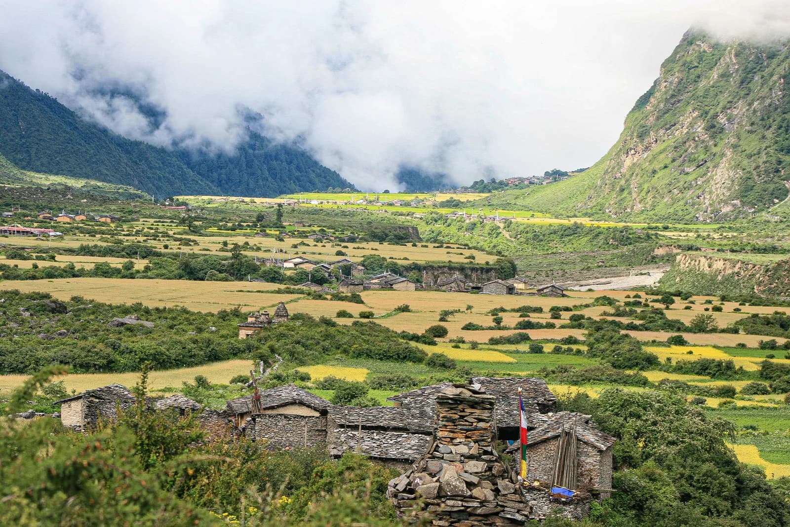
Tsum Valley Trek
A 13-day restricted-area trek into the hidden Tsum Valley north of Philim, with Chumling, Chhokangparo, Nile, Mu Gompa and Rachen Gompa, reached by road from Kathmandu.
- روز13
- بیشینه ارتفاع۳٬۷۰۰ متر
- مسافت۱۳۱ کیلومتر
- صعود۷٬۶۱۱ متر
- دشواریسخت
- بهترین ماههاMar–May, Oct–Nov
- مجوزها3
عکس: Sharadgurung7711 · CC BY-SA 4.0
به انگلیسی نمایش داده میشود — هنوز ترجمه نشده است.
این برنامهٔ سفر پیشنویس است و هنوز بررسی نشده. همیشه مراحل را با راهنمای خود تأیید کنید.
Written by FindTrekkingPartner teamبررسیشده توسط FindTrekkingPartner teamروش بررسی ماFindTrekkingPartner
Tsum Valley Trek یک مسیر پیادهروی 13 روزه در منطقه Manaslu نپال است که تا ۳٬۷۰۰ متر بالا میرود. پیادهروهای خارجی میتوانند در FindTrekkingPartner با ثبت یک سفر همراه با تاریخ، بودجه و سرعت خود، برای آن همسفر پیدا کنند. تا زمانی که هر دو پیادهرو موافقت نکنند، تطابقها خصوصی میمانند و این سرویس رایگان است. با نرخهای متوسط، یک راهنمای دارای مجوز وقتی چهار پیادهرو سهم میدهند حدود ۹۸ دلار آمریکا (USD) برای هر نفر در 13 روز هزینه دارد، در مقابل ۳۹۳ دلار آمریکا (USD) برای یک پیادهرو بهتنهایی. بهترین فصلها Mar–May, Oct–Nov هستند. این یک منطقه محدودشده است، بنابراین داشتن راهنمای دارای مجوز از طریق یک آژانس ثبتشده بخشی از مجوز است و کل گروه با یک مجوز آژانس سفر میکند. آخرین بررسی: ۲۷ مهر ۱۴۰۵. منابع: هیئت گردشگری نپال، DNPWC، اداره مهاجرت.
منابع:Department of Immigration, NepalNepal Tourism BoardDepartment of National Parks and Wildlife Conservation
یافتن همسفر برای Tsum Valley Trek
- یافتن همسفر برای Tsum Valley Trekهنوز سفر بازی نیست
- یافتن همسفر برای Manaslu Circuit Trek۴ سفر باز
نمای کلی
شروع از Kathmandu۱۳ روز · حداکثر ۳٬۷۰۰ متر
بهترین فصلها: Mar–May, Oct–Nov · مجوزها: Tsum Valley restricted area permit (Department of Immigration, via a registered agency), Manaslu Conservation Area entry permit, TIMS card where required
The Tsum Valley trek is a 13-day journey into a hidden Buddhist valley in the north of Gorkha District, close to the Tibetan border, branching off the Manaslu trail at Philim. It drives from Kathmandu to Machha Khola, follows the Budhi Gandaki valley to Jagat and Lokpha, then climbs through Chumling and Chhokangparo to Nile and Mu Gompa, at about 3,700 m, before returning by Rachen Gompa and the same trail. The route covers about 131 km on foot with 7,600 m of climbing, and the valley is a restricted area inside the Manaslu Conservation Area, so you need a Restricted Area Permit through a registered agency, the conservation area permit and a licensed guide. The trek is hard because of the long days and steady altitude, and the best months are October and November, and March to May. It suits fit trekkers who want culture, monasteries and quiet trails rather than high passes.
What the trek is like
The trail follows the Budhi Gandaki through steep gorge country, with suspension bridges, waterfalls and forest, and some sections now run beside a jeep road. At Philim the Tsum Valley branch turns north through bamboo and oak forest to Lokpha and Chumling, the first Tsum village at about 2,360 m. Above it the valley opens into terraces of barley and buckwheat, stone houses with prayer flags, and long mani walls. Chhokangparo and Nile are the main bases for the upper valley, and Mu Gompa, near the border, is the last stop. The return passes Rachen Gompa and follows the river down to Machha Khola.
Highlights
- Mu Gompa, the highest and most remote monastery in the valley, near the Tibetan border
- Rachen Gompa, a nunnery, and the Milarepa cave, associated with the Tibetan saint
- Terraced villages with mani walls, chortens and traditional stone houses
- Views of Ganesh Himal, Sringi Himal and the Boudha Himal range
- A quiet, hidden valley that opened to trekkers only in 2008
Permits and rules
The Tsum Valley is a restricted area, so you need a Restricted Area Permit from the Department of Immigration, issued through a registered agency, plus the Manaslu Conservation Area entry permit and a TIMS card where required. A licensed guide must accompany you. Reports of a March 2026 notice say individual foreigners may apply, but the permit still needs an agency and a guide. Fees and day counts have changed more than once, so ask the agency for the current amounts and check them with the Department of Immigration. Carry several copies of your passport and permits for the check posts at Jagat and Philim.
Best season
October and November have the clearest weather, and March to May bring rhododendron and warmer days. The monsoon has leeches, landslides and cloud on the Machha Khola road, and winter is cold, with snow around Mu Gompa and many lodges closed. Allow a spare day for the road.
Altitude
The highest point is Mu Gompa at about 3,700 m, and the valley sleeps between 850 m and 3,680 m. The climbs are steady, with the biggest gains on the days to Chumling and Chhokangparo. Watch for headache, nausea and poor sleep, never ascend with symptoms, and descend if they worsen. Discuss altitude medicine with your doctor before the trek.
Getting there and away
Drive from Kathmandu to Machha Khola via Dhading, Arughat and Soti Khola, about 8 to 9 hours in a jeep on a rough and dusty road that can be blocked by landslides in the monsoon. The return is the same drive on the last day, and some groups use a jeep for part of the Jagat to Machha Khola section. Keep a spare day in the schedule.
Lodges, food and costs
Simple lodges and homestays operate in every village, with dal bhat, noodles, potatoes, tsampa and tea, and rooms with blankets. In the upper valley, facilities are basic and some places close in the off season. Prices rise with altitude, and you should bring cash for the whole trek, because there are no machines on the trail.
Packing list
Broken-in boots, waterproof layers, a down jacket, a sleeping bag rated to about minus 10 C, gloves, hat, sunglasses, sun cream, trekking poles, a headlamp, water purification and a first-aid kit. Add leech socks in wet months and a scarf or shawl to wear in monasteries.
Who this trek suits and how to prepare
The trek suits fit trekkers who like culture and quiet trails. The days are long, with 14 to 17 km on several, so prepare with hill walks and some days with a loaded pack. Respect for local customs, including photography rules, is part of the preparation.
The plan at a glance
Day 1 drives to Machha Khola. Days 2 to 4 walk to Jagat, Lokpha and Chumling. Days 5 to 7 go to Chhokangparo, Nile and Mu Gompa. Day 8 walks to Rachen Gompa and day 9 returns to Chumling. Days 10 to 12 return to Lokpha, Jagat and Machha Khola, and day 13 drives to Kathmandu.
Extensions
Add a day at Mu Gompa to explore the upper valley or walk toward the Tibetan border viewpoints, visit the Milarepa cave and Rachen Gompa on an extra night, or continue to the Manaslu Circuit from Philim, which adds about a week and the Larkya La. Check the permits for each route with your agency.
Practical tips from the trail
- Walking times in the day plan are estimates from distance and climb, checked against operator itineraries; real times differ with pace, load and weather.
- Start early on the long days and keep a steady pace.
- Dress modestly and ask before taking photographs inside monasteries.
- Walk clockwise around mani walls and chortens.
- Carry cash in small notes, as villages have no machines.
- Keep a spare day for the Machha Khola road.
Responsible trekking
Take rubbish out, use filtered water, buy from local families and respect the valley's customs. Do not give sweets or money to children.
نکات برجسته
- Mu Gompa, the high monastery near the Tibetan border at about 3,700 m
- Rachen Gompa, a nunnery, and the Milarepa cave area
- Chumling, Chhokangparo and Nile, Tibetan-style villages
- Views of Ganesh Himal and Sringi Himal from the valley
- A trek of culture with few other trekkers
نقشه مسیر
دادههای مسیر از OpenStreetMap است و هنوز تیم ما آن را بررسی نکرده است. برای برنامهریزی استفاده کنید، نه مسیریابی.
روزبهروز
The first walking day follows the Budhi Gandaki from Machha Khola to Jagat at about 1,320 m, about 17 km with a climb of 1,300 m, taking 7 to 8 hours. The trail crosses suspension bridges, passes hot springs at Tatopani and winds through gorge forest, with some sections beside the jeep road. Jagat is a stone-paved village and the main checkpoint of the Manaslu region, where your permits are inspected. Rest, drink water and keep an eye out for leeches in wet weather.
شما ۶۰۰ متر بالاتر از شب قبل میخوابید، بیش از حد معمول ۵۰۰ متر. آهسته بروید، زیاد آب بنوشید و مراقب سردرد یا تهوع باشید.
Walk from Jagat to Lokpha via Philim, about 14 km with a climb of 1,030 m, taking 6 to 7 hours. The trail follows the river, then at Philim the Tsum route turns north into a narrower valley of bamboo and oak forest. Lokpha, at about 1,920 m, is a small settlement with lodges, and it is the gateway to the Tsum Valley. Your permits are checked again here. The air is cooler and the scenery greener. Rest early, because the trail climbs on the next day.
A moderate climb from Lokpha to Chumling at about 2,360 m, about 8 km with a climb of 890 m, taking 4 to 5 hours. The trail passes through forest and crosses side streams on bridges, with views of Ganesh Himal ahead. Chumling is the first Tsum village, with stone houses, mani walls, a gompa and lodges, and it feels like the start of a different culture. Walk around the village in the afternoon and visit the gompa. The nights are cool, so put on warm layers.
شما ۷۱۰ متر بالاتر از شب قبل میخوابید، بیش از حد معمول ۵۰۰ متر. آهسته بروید، زیاد آب بنوشید و مراقب سردرد یا تهوع باشید.
Walk from Chumling to Chhokangparo, also called Chhekampar, at about 3,070 m, about 11 km with a climb of 1,050 m, taking 5 to 6 hours. The trail passes through terraced fields, forest and small villages, with long mani walls and chortens beside the path. Chhokangparo is a large village with lodges and views of Ganesh Himal and Sringi Himal. The altitude is noticeable, so drink water and walk slowly. Spend the afternoon exploring the village and its monastery. Keep your camera ready for the mani walls.
A moderate walk from Chhokangparo to Nile at about 3,300 m, about 11 km with a climb of 390 m, taking 3.5 to 5 hours. The route follows terraces and meadows along the valley, passing Chule and small hamlets, with mani walls and views of the Tsum villages. Nile is a village near the head of the valley, with lodges and a gompa. The day is easy in terms of altitude, which helps acclimatisation. Rest, eat well and prepare for the walk to Mu Gompa.
Walk from Nile to Mu Gompa at about 3,680 m, about 5 km with a climb of 540 m, taking 2.5 to 3.5 hours. The trail follows the valley through barley fields and meadows with views of snow peaks and the Tibetan border. Mu Gompa is the highest and most remote monastery of the Tsum Valley, a centre of Buddhist learning. Visit respectfully, ask before taking photographs and walk clockwise around the chortens. Spend the afternoon resting, because the altitude is the highest of the trek.
Descend from Mu Gompa to Rachen Gompa at about 3,220 m, about 10 km with a drop of 680 m, taking 3 to 4 hours. The route returns down the valley through Nile and Pangdun to the Rachen nunnery near Lar, and the Milarepa cave is nearby. The nunnery is home to Buddhist nuns, and visitors should be quiet and respectful. The walk gives new views of the valley and the mountains. Rachen Gompa has simple lodges nearby. Dress modestly and bring a scarf for your visit.
A long descent from Rachen Gompa to Chumling at about 2,360 m, about 16 km with a drop of 1,280 m and a climb of 410 m, taking 5 to 6 hours. The trail follows the valley down through villages, forest and terraces, and the air thickens as you drop. Chumling feels warm after the high villages, and its lodges offer hot meals. Use poles to protect your knees on the steep sections. Rest, wash and enjoy the evening in the village.
Walk from Chumling to Lokpha at about 1,920 m, about 8 km with a descent of 900 m and a climb of 460 m, taking 3 to 4 hours. The trail retraces the forest path, with waterfalls and bridges, and the temperature rises as you descend. Lokpha is a small settlement with lodges, and your permits are checked again. The pace is easy, so you have time to rest and wash clothes. Keep an eye out for leeches in wet weather.
Walk from Lokpha to Jagat via Philim at about 1,320 m, about 14 km with a descent of 1,030 m and a climb of 460 m, taking 4.5 to 6 hours. The trail follows the valley down to the Budhi Gandaki and back along the river, with suspension bridges and gorge views. Jagat is a stone-paved village with lodges and a checkpoint. The air is warm and humid, and the nights feel mild after the high villages. Rest and enjoy a hot meal.
A long walk from Jagat to Machha Khola at about 850 m, about 17 km with a descent of 1,340 m and a climb of 850 m, taking 6 to 7 hours. The trail follows the Budhi Gandaki past Tatopani's hot springs, with suspension bridges, waterfalls and forest, and some sections beside the jeep road. It is the last walking day, so enjoy the views. Machha Khola's lodges are simple, and the village is a good place to thank your crew and porters.
شما ۵۵۰ متر بالاتر از شب قبل میخوابید، بیش از حد معمول ۵۰۰ متر. آهسته بروید، زیاد آب بنوشید و مراقب سردرد یا تهوع باشید.
Drive from Machha Khola back to Kathmandu, about 8 to 9 hours via Soti Khola, Arughat and Dhading. The road is rough and dusty at first and improves as you reach the highway. Leave early to arrive in Kathmandu in the afternoon, and keep a spare day in the schedule in case landslides block the road. Back in the hotel, shower, repack and celebrate with a good dinner. Tip your guide and porters according to your agency's guidelines. Keep your passport and permit copies in your hand luggage.
سازگاری با ارتفاع
ارتفاع خواب شببهشب. ستونهای قرمز بیش از ۵۰۰ متر از شب قبل بالاتر میروند؛ روزهای استراحت مشخص شدهاند.
- ارتفاع خواب
- افزایش بیش از ۵۰۰ متر
- روز استراحت
هزینهها
برآورد هزینه کل برای هر نفر: اقامتگاه و غذا بر اساس ارتفاع، حملونقل، مجوزها، و راهنما و باربرها. هر چه ترکرهای بیشتری راهنما و باربر را تقسیم کنند، سهم هر نفر کمتر میشود. تا تاریخ ۱۴۰۵ مهر.
| سبک | ۱ ترکر | ۲ ترکر با تقسیم هزینه | ۴ ترکر با تقسیم هزینه |
|---|---|---|---|
| اقتصادی | $۶۵۰–$۹۳۰ | $۴۸۰–$۷۱۰ | $۴۰۰–$۵۹۰ |
| میانرده | $۱٬۲۵۰–$۱٬۸۰۰ | $۸۲۰–$۱٬۲۰۰ | $۶۴۰–$۹۵۰ |
| راحت | $۱٬۳۵۰–$۱٬۹۵۰ | $۱٬۰۰۰–$۱٬۵۰۰ | $۸۴۰–$۱٬۲۵۰ |
راهنما را تقسیم کنید، پول پسانداز کنید
در سطح میانرده، یک ترکر تنها حدود $۱٬۲۵۰–$۱٬۸۰۰ میپردازد؛ چهار ترکر که یک راهنما و دو باربر را تقسیم میکنند هر کدام حدود $۶۴۰–$۹۵۰ میپردازند (46٪ کمتر در بالای بازه).
جزئیات برای ۲ ترکر با تقسیم هزینه
| مورد | اقتصادی | میانرده | راحت |
|---|---|---|---|
| اقامتگاه و غذا | $۲۱۰–$۳۵۰ | $۲۹۰–$۴۸۰ | $۴۰۰–$۶۳۰ |
| حملونقل | $۱۰–$۳۰ | $۱۷۰–$۲۳۰ | $۱۷۰–$۲۳۰ |
| مجوزها | $۹۰–$۱۱۰ | $۹۰–$۱۱۰ | $۹۰–$۱۱۰ |
| راهنما | $۱۶۰–$۲۳۰ | $۱۶۰–$۲۳۰ | $۱۶۰–$۲۳۰ |
| باربرها | — | $۸۰–$۱۴۰ | $۱۷۰–$۲۸۰ |
سبک اقتصادی از حملونقل عمومی و بدون باربر استفاده میکند؛ میانرده یک باربر را بین دو ترکر و یک وسیله نقلیه اختصاصی تقسیم میکند؛ راحت برای هر ترکر یک باربر در نظر میگیرد. راهنما در جایی که الزامی است یا سبک میانرده یا راحت باشد لحاظ میشود.
اقامتگاه و غذای هر شب (اتاق و یک وعده دال بهات)
۸ شب Below 2,500 m: اتاق $۲–$۹، دال بهات $۴–$۷ · ۴ شب 2,500 to 3,800 m: اتاق $۴–$۱۱، دال بهات $۵–$۱۱
هزینه مجوزها (منابع رسمی)
منابع هزینه
- PriceNepal: Nepal Travel Cost Guide 2026 (2026-05-14)
- Third Rock Adventures: Nepal trek budget planner (2026-05-09)
- Himalayan Partner: Guide and porter price in Nepal 2026 (2026-02-10)
- Shikhar Adventure: Annapurna Circuit trek cost (2026-02-03)
- Nepal Tourism Board: Trekking Permit (2026-10-18)
برآوردها از راهنماهای اپراتورها هستند، نه قیمت قطعی. انعام، بیمه، تجهیزات و هتلهای کاتماندو شامل نمیشود؛ دلار آمریکا با نرخ تبدیل پلتفرم.
عکسها
پرسشهای متداول
Yes, a Restricted Area Permit from the Department of Immigration through a registered agency, plus the Manaslu Conservation Area permit and a TIMS card where required. Ask for current fees.
No. A licensed guide is compulsory in the restricted area. Reports say that since March 2026 individuals may apply for the permit, but a registered agency and guide are still required.
Thirteen days from Kathmandu on this plan, including two driving days, eleven walking days and a return by the same trail. Many agencies allow 14 to 16 days.
The valley runs from about 1,900 m to over 4,000 m, and this trek reaches about 3,700 m at Mu Gompa.
October and November, and March to May. The monsoon has leeches and landslides, and winter closes some lodges.
Yes. The Tsum Valley branches from the Manaslu trail at Philim, and agencies sell combined treks of 20 days or more, but each part needs its own permit.
It is a high monastery near the Tibetan border and a centre of Buddhist learning in the valley, at about 3,700 m. Visit respectfully and ask before taking photographs.
منابع
- Tsum Valley Trek, 16 days (Ace the Himalaya)
- Tsum Valley Trek (Marron Treks)
- Tsum Valley (Wikipedia)
- Manaslu Conservation Area (Wikipedia)
- Department of Immigration, Nepal
- Restrictions on trekking for foreigners in controlled areas of 13 districts (Kantipur, 6 May 2026)
- Nepal Tourism Board
- Himalayan Rescue Association
- OpenStreetMap (elevation tags of passes, villages and monasteries)
در طول مسیر
اقامتگاه، کمک پزشکی، آب و جاهای دیدنی در هر روز مسیر.
1. Kathmandu → Machha Khola
- Tribhuvan International Airport · فرودگاهها و حملونقل · ۱٬۳۴۰ متر
2. Machha Khola → Jagat
- Manaslu Hotel & Lodge · اقامتگاهها · ۸۵۹ متر
- Viewpoint of Ganesh Himal & landslide area · چشماندازها · ۹۴۴ متر
- Hot Springs · طبیعت · ۹۸۲ متر
- Himalayan Tourist Guest House · اقامتگاهها · ۱٬۳۳۵ متر
- Manaslu Shani Hotel & Lodge · اقامتگاهها · ۱٬۳۵۳ متر
- Rubinala Inn · اقامتگاهها · ۱٬۳۴۰ متر
Show all 11 places
- Manaslu Hotel & Lodge · اقامتگاهها · ۸۵۹ متر
- Mt. Everest Hotel · اقامتگاهها · ۸۷۹ متر
- Shangri La Hotel · اقامتگاهها · ۸۹۰ متر
- Viewpoint of Ganesh Himal & landslide area · چشماندازها · ۹۴۴ متر
- Hot Springs · طبیعت · ۹۸۲ متر
- Budhi Gandaki Valley Gusethouse · اقامتگاهها · ۹۸۳ متر
- Thulodhunga Hotel and Lodge · اقامتگاهها · ۱٬۱۴۶ متر
- Hosanna · اقامتگاهها · ۱٬۳۰۰ متر
- Himalayan Tourist Guest House · اقامتگاهها · ۱٬۳۳۵ متر
- Manaslu Shani Hotel & Lodge · اقامتگاهها · ۱٬۳۵۳ متر
- Rubinala Inn · اقامتگاهها · ۱٬۳۴۰ متر
3. Jagat → Lokpha
- Jagat Health Unit · پزشکی · ۱٬۳۳۵ متر
- Royal Guest House · اقامتگاهها · ۱٬۵۷۴ متر
- Gorkha view hotel · اقامتگاهها · ۱٬۵۶۲ متر
- Laprak Gurung Bamboo Cottage & Restaurant · اقامتگاهها · ۱٬۶۳۳ متر
- Viewpoint · چشماندازها · ۱٬۸۹۸ متر
- Chum Gate Way Hotel & Lodge · اقامتگاهها · ۱٬۹۲۵ متر
Show all 7 places
- Jagat Health Unit · پزشکی · ۱٬۳۳۵ متر
- Royal Guest House · اقامتگاهها · ۱٬۵۷۴ متر
- Gorkha view hotel · اقامتگاهها · ۱٬۵۶۲ متر
- Laprak Gurung Bamboo Cottage & Restaurant · اقامتگاهها · ۱٬۶۳۳ متر
- Chum Nubri Ekle Bhatti Chisopi Guest House · اقامتگاهها · ۱٬۶۳۳ متر
- Viewpoint · چشماندازها · ۱٬۸۹۸ متر
- Chum Gate Way Hotel & Lodge · اقامتگاهها · ۱٬۹۲۵ متر
4. Lokpha → Chumling
- Viewpoint · چشماندازها · ۱٬۹۱۱ متر
- Drinking Water · کاربردی · ۲٬۱۶۱ متر
- Chumling Guest House · اقامتگاهها · ۲٬۳۴۱ متر
- Tashi Delek Lobsang Lodge & Restaurant · اقامتگاهها · ۲٬۳۴۱ متر
5. Chumling → Chhokangparo
- Trekker's Home · اقامتگاهها · ۳٬۰۶۵ متر
6. Chhokangparo → Nile
- Milarepa Hotel & Lodge · اقامتگاهها · ۳٬۰۵۸ متر
- Kyimulung Hotel & Lodge · اقامتگاهها · ۳٬۲۱۰ متر
- Tsum Valey Pangpoche Guest House · اقامتگاهها · ۳٬۲۲۴ متر
- Drinking Water · کاربردی · ۳٬۲۷۸ متر
- Nile Norling Guest House · اقامتگاهها · ۳٬۳۰۸ متر
Show all 6 places
- Milarepa Hotel & Lodge · اقامتگاهها · ۳٬۰۵۸ متر
- Kyimulung Hotel & Lodge · اقامتگاهها · ۳٬۲۱۰ متر
- Tsum Valey Pangpoche Guest House · اقامتگاهها · ۳٬۲۲۴ متر
- Drinking Water · کاربردی · ۳٬۲۷۸ متر
- Kagni Lodge · اقامتگاهها · ۳٬۲۹۵ متر
- Nile Norling Guest House · اقامتگاهها · ۳٬۳۰۸ متر
7. Nile → Mu Gompa
- Mu Gumba · اقامتگاهها · ۳٬۶۸۶ متر
8. Mu Gompa → Rachen Gompa
- Birthing Center & Outreach Clinic · پزشکی · ۳٬۲۵۳ متر
9. Rachen Gompa → Chumling
- Peaceful Hotel & Lodge · اقامتگاهها · ۳٬۰۷۰ متر
- Drinking Water · کاربردی · ۲٬۵۵۷ متر
- Domje · اقامتگاهها · ۲٬۵۰۶ متر
- Chameri Himal Guest House · اقامتگاهها · ۲٬۴۴۲ متر
- Tsum Jhambala Hotel & Restaurant · اقامتگاهها · ۲٬۲۶۹ متر
Show all 6 places
- Peaceful Hotel & Lodge · اقامتگاهها · ۳٬۰۷۰ متر
- Drinking Water · کاربردی · ۲٬۵۵۷ متر
- Domje · اقامتگاهها · ۲٬۵۰۶ متر
- Chameri Himal Guest House · اقامتگاهها · ۲٬۴۴۲ متر
- Renzam Ganesh Himal Guest House · اقامتگاهها · ۲٬۴۳۷ متر
- Tsum Jhambala Hotel & Restaurant · اقامتگاهها · ۲٬۲۶۹ متر
10. Chumling → Lokpha
هنوز چیزی برای این روز روی نقشه نیست.هنوز چیزی برای این روز روی نقشه نیست.11. Lokpha → Jagat
- Tsum Guest House · اقامتگاهها · ۱٬۹۱۹ متر
- Tashi Delek Lobshang Lodge & Restaurant · اقامتگاهها · ۱٬۹۱۹ متر
- Hotel Motherland Tsum · اقامتگاهها · ۱٬۹۱۰ متر
- Viewpoint · چشماندازها · ۱٬۸۸۶ متر
- Mongolian cottage · اقامتگاهها · ۱٬۳۳۴ متر
Show all 12 places
- Tsum Guest House · اقامتگاهها · ۱٬۹۱۹ متر
- Tashi Delek Lobshang Lodge & Restaurant · اقامتگاهها · ۱٬۹۱۹ متر
- Hotel Motherland Tsum · اقامتگاهها · ۱٬۹۱۰ متر
- Viewpoint · چشماندازها · ۱٬۸۸۶ متر
- Nyak Phedi Guest House · اقامتگاهها · ۱٬۶۸۱ متر
- Kham-Sangbo Hotel & Lodge · اقامتگاهها · ۱٬۸۰۱ متر
- Akley Bhatti Hotel & Lodge · اقامتگاهها · ۱٬۶۲۰ متر
- Ekelebhatti Long Bridge Guest House & Restaurant · اقامتگاهها · ۱٬۶۱۱ متر
- Hulchuki hotel and restaurant · اقامتگاهها · ۱٬۵۶۴ متر
- Philim village and lodge · اقامتگاهها · ۱٬۵۷۰ متر
- Shrinki Guest House · اقامتگاهها · ۱٬۳۳۶ متر
- Mongolian cottage · اقامتگاهها · ۱٬۳۳۴ متر
12. Jagat → Machha Khola
- Jagat Guest House · اقامتگاهها · ۱٬۳۴۶ متر
- Yuru Khola · اقامتگاهها · ۱٬۲۷۹ متر
- Punngpu · طبیعت · ۱٬۳۱۰ متر
- Hot Springs · طبیعت · ۸۱۶ متر
- Hotel Chumvally Restaurant and Lodge · اقامتگاهها · ۸۶۲ متر
- Hotel Hilltop · اقامتگاهها · ۸۵۷ متر
Show all 12 places
- Jagat Guest House · اقامتگاهها · ۱٬۳۴۶ متر
- Yuru Khola · اقامتگاهها · ۱٬۲۷۹ متر
- Yaru Guest House · اقامتگاهها · ۱٬۳۲۶ متر
- Punngpu · طبیعت · ۱٬۳۱۰ متر
- Royal Mountain Hotel & Lodge · اقامتگاهها · ۹۸۴ متر
- 18 Saya Khola Family Guest House · اقامتگاهها · ۹۸۷ متر
- Sangri La Hotel · اقامتگاهها · ۸۸۴ متر
- River View Guest House · اقامتگاهها · ۸۸۱ متر
- Sem Jang Ganesh Hotel · اقامتگاهها · ۸۸۸ متر
- Hot Springs · طبیعت · ۸۱۶ متر
- Hotel Chumvally Restaurant and Lodge · اقامتگاهها · ۸۶۲ متر
- Hotel Hilltop · اقامتگاهها · ۸۵۷ متر
13. Machha Khola → Kathmandu
هنوز چیزی برای این روز روی نقشه نیست.هنوز چیزی برای این روز روی نقشه نیست.
آخرین بررسی در ۲۷ مهر ۱۴۰۵گزارش اطلاعات قدیمی