

Leave Kathmandu early for the drive north to Syabrubesi, at about 1,500 m, on the Trisuli road past Trisuli Bazaar and the approach to Langtang. Operators give 6 to 9 hours depending on the vehicle and the state of the road; the bus is slower and cheaper than a jeep. The road is narrow and winding, with some landslide sections. Syabrubesi is the busy start of the Langtang and Tamang Heritage routes, so you will see other trekkers. Check in to a lodge, confirm your permit paperwork with the guide, pack a daypack and have an early night before the first walking day.
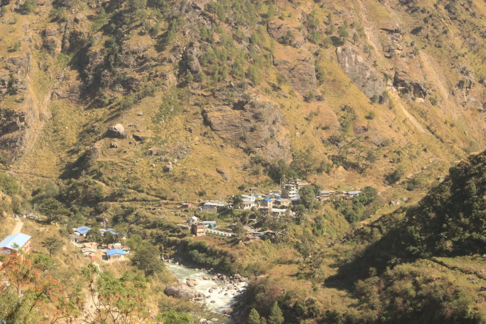
Ruby Valley and Ganesh Himal Trek
A 7-day village trek from Syabrubesi over Pangsang Pass to Tipling and Chalish, with a rest day around Chalish and a drive back through Dhading Besi.
- روز7
- بیشینه ارتفاع۳٬۸۵۰ متر
- مسافت۴۳٫۷ کیلومتر
- صعود۳٬۶۳۸ متر
- دشواریمتوسط
- بهترین ماههاMar–May, Oct–Nov
- مجوزها2
با این برنامه سفر بسازیدبرای Ruby Valley and Ganesh Himal Trek همراه پیدا کنیدمشاهده حرکتها بر اساس هفته
عکس: Rajivkilanashrestha · CC BY-SA 4.0
هشدارRuby Valley: the Syabrubesi start is not currently reliable
This route drives to Syabrubesi on day 1 and finishes at Chalish with a drive back through Dhading Besi. On 26 August 2026 a large rock-and-ice collapse from the north face of Langtang Lirung sent a debris flow down the Lhende Khola into the Bhote Koshi and Trishuli rivers, hitting Rasuwagadhi, Timure, Syabrubesi and Betrawati (ICIMOD). Many bridges and long stretches of the Pasang Lhamu Highway were damaged, and a large number of people died or are missing; reported figures differ by source.
Syabrubesi, the usual Langtang road-head, is reported destroyed or closed as a trekking gateway, with the bridge to it swept away; restoration depends on the Betrawati highway reopening. The Trishuli Bazaar-Betrawati-Dhunche road was reported still closed for repair as of 21 September. A light-vehicle track has reopened, and agencies projected the remaining gaps passable no earlier than mid-October; that is a projection, not an official date.
We found no source on the condition of the Ruby Valley trail itself or a reopening date. We found no official reopening notice. Check current road and trail conditions with Langtang National Park and your trekking agency before booking, and do not rely on this summary alone.
وضعیت در تاریخ 2026-10-19 بررسی شد.
منابع: ICIMOD: Kyirong-Rasuwa flood, 26 August 2026 · Nepal Pyramids: Langtang Valley trek update after the 2026 flooding · Republica: locals reopen flood-damaged Langtang trekking route (16 Oct)
به انگلیسی نمایش داده میشود — هنوز ترجمه نشده است.
این برنامهٔ سفر پیشنویس است و هنوز بررسی نشده. همیشه مراحل را با راهنمای خود تأیید کنید.
Written by FindTrekkingPartner teamبررسیشده توسط FindTrekkingPartner teamروش بررسی ماFindTrekkingPartner
Ruby Valley and Ganesh Himal Trek یک مسیر پیادهروی 7 روزه در منطقه Ganesh Himal نپال است که تا ۳٬۸۵۰ متر بالا میرود. پیادهروهای خارجی میتوانند در FindTrekkingPartner با ثبت یک سفر همراه با تاریخ، بودجه و سرعت خود، برای آن همسفر پیدا کنند. تا زمانی که هر دو پیادهرو موافقت نکنند، تطابقها خصوصی میمانند و این سرویس رایگان است. با نرخهای متوسط، یک راهنمای دارای مجوز وقتی چهار پیادهرو سهم میدهند حدود ۶۵ دلار آمریکا (USD) برای هر نفر در 7 روز هزینه دارد، در مقابل ۲۶۱ دلار آمریکا (USD) برای یک پیادهرو بهتنهایی. بهترین فصلها Mar–May, Oct–Nov هستند. در عمل در اینجا راهنمای دارای مجوز لازم است: بر اساس گزارشهای فعالان تور در 2026، قانون آوریل 2023 هیئت گردشگری نپال در ایستهای بازرسی پارکهای ملی و مناطق حفاظتشده اجرا میشود؛ لانگتانگ سختگیرترین است و آناپورنا نیز بازرسی میکند (بررسیشده در 19 اکتبر 2026). راهنما را از طریق یک آژانس ثبتشده بگیرید و با آنها تأیید کنید. آخرین بررسی: ۲۷ مهر ۱۴۰۵. منابع: هیئت گردشگری نپال، DNPWC، اداره مهاجرت.
منابع:Department of Immigration, NepalNepal Tourism BoardDepartment of National Parks and Wildlife Conservation
یافتن همسفر برای Ruby Valley and Ganesh Himal Trek
- یافتن همسفر برای Ruby Valley and Ganesh Himal Trekهنوز سفر بازی نیست
نمای کلی
شروع از Kathmanduگردنهها: Pangsang Pass۷ روز · حداکثر ۳٬۸۵۰ متر
بهترین فصلها: Mar–May, Oct–Nov · مجوزها: Langtang National Park entry permit, TIMS card where required
The Ruby Valley trek is a seven-day walk through the villages and forests on the south-west side of Ganesh Himal. It drives from Kathmandu to Syabrubesi, the Langtang trailhead, walks over Bahun Danda to the Tamang village of Gatlang, climbs to the forest camp at Somdang (about 3,270 m), crosses Pangsang Pass at about 3,850 m and descends to Tipling, then walks through the Tamang village of Sertung to Chalish, with a rest day around Chalish for Sertung and the Tatopani hot spring before a drive back to Kathmandu via Dhading Besi. The walking adds up to about 44 km on our mapped route with roughly 3,600 m of climbing, following the stages of the Nepal Alternative Treks, Himalaya Trip and Peregrine itineraries in the sources. It is a moderate trek, needs the Langtang National Park permit and no restricted-area permit, and runs best from late September to early December and in spring.
What the trek is like
The first day on foot climbs from the Bhote Koshi valley through forest to Bahun Danda and on to Gatlang, a village of dark stone houses at about 2,300 m. The next two days go up into pine and rhododendron forest to Somdang and over Pangsang Pass, where on clear days Ganesh Himal fills the northern horizon. The final descent leads through millet and maize terraces to Tipling and Chalish, villages where local families run homestays.
Permits and rules
The Langtang National Park entry permit is NPR 3,000 for foreigners (Nepal Tourism Board). A TIMS card is listed by some operators. The trek is not in a restricted area, so there is no minimum group size, but trails above Somdang are quiet, so most people go with a guide.
Best season
Mid-September to mid-December and March to May. Monsoon trails are slippery and leech-prone.
Altitude
The highest overnight is Somdang at about 3,270 m and the pass is about 3,850 m, so most people feel the height only as a little breathlessness. Walk slowly and drink well.
Getting there and away
Kathmandu to Syabrubesi is 6 to 9 hours by road, and Chalish to Kathmandu about 8 hours via Dhading Besi. Plan one spare day if road works or landslides are reported.
Lodges, food and costs
Homestays and simple guesthouses serve dal bhat. See the permit fees and sample costs in the costs section.
Extensions
Operators extend the trek with an acclimatisation day at Somdang, a walk on to Jharlang and Darkha, or a longer circuit through Hindung to Ganesh Himal Base Camp, which has no lodges.
نکات برجسته
- Gatlang, a Tamang village of stone houses and pilgrim lake
- Somdang, a forest camp at about 3,270 m below Ganesh Himal
- Pangsang Pass at about 3,850 m, with views of the Ganesh Himal range
- Tipling and Chalish, farming villages with homestays and the Tatopani hot spring nearby
- A moderate trek with no restricted-area permit
نقشه مسیر
دادههای مسیر از OpenStreetMap است و هنوز تیم ما آن را بررسی نکرده است. برای برنامهریزی استفاده کنید، نه مسیریابی.
روزبهروز
شما ۸۳۴ متر بالاتر از شب قبل میخوابید، بیش از حد معمول ۵۰۰ متر. آهسته بروید، زیاد آب بنوشید و مراقب سردرد یا تهوع باشید.
Cross to the west bank of the Bhote Koshi and climb through forest and farmland over Bahun Danda to Gatlang, at about 2,300 m. Operators allow 4 to 6 hours for the 11 km, and the gain is about 1,060 m. Gatlang is a Tamang village of stone houses, wooden balconies and prayer flags, with a pilgrim lake nearby. Walk through the lanes in the afternoon, and be respectful when entering temples or taking photos of people. Homestay families cook dal bhat and local food. The altitude is modest, but drink a lot and climb slowly.
شما ۹۳۴ متر بالاتر از شب قبل میخوابید، بیش از حد معمول ۵۰۰ متر. آهسته بروید، زیاد آب بنوشید و مراقب سردرد یا تهوع باشید.
A long day of 6 to 7 hours takes you from Gatlang to Somdang, at about 3,270 m, climbing about 1,500 m over 12.6 km. The trail goes through dense pine and rhododendron forest, passing Khurpu Bhanjyang, a saddle of about 3,700 m on the map, before the final stretch to Somdang. The hamlet has a few guesthouses on a clearing with views down the valley. It is the highest night of the trek, so go slowly, eat well and wrap up in the evening, when the air turns cold quickly.
The hardest day: leave early and climb above the tree line to Pangsang Pass, at about 3,850 m, where the views take in the Ganesh Himal range on a clear morning. Then descend steeply through forest to Tipling, at about 2,000 m, a drop of about 1,800 m from the pass over 15 km on our mapped route. Operators allow 7 to 8 hours in total, and some call it 8 to 10, so start at first light and carry lunch. Poles are a great help on the knee-jarring descent. Tipling's homestays give a welcome rest at the end.
Walk down from Tipling through millet and maize terraces to Sertung, a Tamang village, and on to Chalish Gaon at about 1,675 m. Operators give 3 to 5 hours for the day, depending on how long you spend among the Sertung houses. Our map follows the footpath through Sertung: 4.7 km with about 360 m of climbing and 690 m of descent, so the day is short on distance but has a lot of up and down. One operator counts 12 km for the same day because it also visits upper villages that OpenStreetMap does not map. Stop in Sertung for tea, then continue to Chalish, home to Gurung, Ghale and Kami families, where the lower altitude and warmer evenings make a pleasant place to rest.
A rest day around Chalish with an optional walk of about 4 to 5 hours: operators suggest a round trip to Sertung, a viewpoint, and the Tatopani hot spring, where you can soak tired legs. The route is gentle and mostly on village paths, and you can shorten it or skip it. Ask your host about a cultural evening if you want music and dance, usually arranged on request. This is also the sensible day to wash clothes, back up photos and repack for the road, because the last day is a long drive.
Drive from Chalish via Dhading Besi to Kathmandu, a journey of about 8 hours on the Dhading and Prithvi roads. Operators quote between 7 and 9 hours with a mix of private jeep and bus; the stretch to Dhading Besi is rough and slow, and the rest is on tarmac. Leave early, take snacks and water, and keep a spare day in your plans if the monsoon or road works are reported. Back in Kathmandu, hand back any rented gear and settle up with the guide and drivers.
سازگاری با ارتفاع
ارتفاع خواب شببهشب. ستونهای قرمز بیش از ۵۰۰ متر از شب قبل بالاتر میروند؛ روزهای استراحت مشخص شدهاند.
- ارتفاع خواب
- افزایش بیش از ۵۰۰ متر
- روز استراحت
هزینهها
برآورد هزینه کل برای هر نفر: اقامتگاه و غذا بر اساس ارتفاع، حملونقل، مجوزها، و راهنما و باربرها. هر چه ترکرهای بیشتری راهنما و باربر را تقسیم کنند، سهم هر نفر کمتر میشود. تا تاریخ ۱۴۰۵ مهر.
| سبک | ۱ ترکر | ۲ ترکر با تقسیم هزینه | ۴ ترکر با تقسیم هزینه |
|---|---|---|---|
| اقتصادی | $۳۴۰–$۴۳۰ | $۲۴۰–$۳۳۰ | $۱۹۰–$۲۸۰ |
| میانرده | $۷۷۰–$۱٬۱۵۰ | $۴۷۰–$۷۰۰ | $۳۴۰–$۵۱۰ |
| راحت | $۸۲۰–$۱٬۲۰۰ | $۵۶۰–$۸۳۰ | $۴۳۰–$۶۵۰ |
راهنما را تقسیم کنید، پول پسانداز کنید
در سطح میانرده، یک ترکر تنها حدود $۷۷۰–$۱٬۱۵۰ میپردازد؛ چهار ترکر که یک راهنما و دو باربر را تقسیم میکنند هر کدام حدود $۳۴۰–$۵۱۰ میپردازند (55٪ کمتر در بالای بازه).
جزئیات برای ۲ ترکر با تقسیم هزینه
| مورد | اقتصادی | میانرده | راحت |
|---|---|---|---|
| اقامتگاه و غذا | $۱۰۰–$۱۷۰ | $۱۳۰–$۲۳۰ | $۱۹۰–$۳۰۰ |
| حملونقل | $۱۰۰–$۱۳۰ | $۱۵۰–$۲۲۰ | $۱۵۰–$۲۲۰ |
| مجوزها | $۳۰–$۴۰ | $۳۰–$۴۰ | $۳۰–$۴۰ |
| راهنما | — | $۱۰۰–$۱۶۰ | $۱۰۰–$۱۶۰ |
| باربرها | — | $۳۰–$۷۰ | $۷۰–$۱۳۰ |
سبک اقتصادی از حملونقل عمومی و بدون باربر استفاده میکند؛ میانرده یک باربر را بین دو ترکر و یک وسیله نقلیه اختصاصی تقسیم میکند؛ راحت برای هر ترکر یک باربر در نظر میگیرد. راهنما در جایی که الزامی است یا سبک میانرده یا راحت باشد لحاظ میشود.
اقامتگاه و غذای هر شب (اتاق و یک وعده دال بهات)
۵ شب Below 2,500 m: اتاق $۲–$۹، دال بهات $۴–$۷ · ۱ شب 2,500 to 3,800 m: اتاق $۴–$۱۱، دال بهات $۵–$۱۱
هزینه مجوزها (منابع رسمی)
منابع هزینه
- PriceNepal: Nepal Travel Cost Guide 2026 (2026-05-14)
- Third Rock Adventures: Nepal trek budget planner (2026-05-09)
- Himalayan Partner: Guide and porter price in Nepal 2026 (2026-02-10)
- Shikhar Adventure: Annapurna Circuit trek cost (2026-02-03)
- Nepal Tourism Board: Trekking Permit (2026-10-18)
- Mount Mania: Ruby Valley trek (2026-10-18)
برآوردها از راهنماهای اپراتورها هستند، نه قیمت قطعی. انعام، بیمه، تجهیزات و هتلهای کاتماندو شامل نمیشود؛ دلار آمریکا با نرخ تبدیل پلتفرم.
عکسها
پرسشهای متداول
It is a moderate trek of 7 days with one hard day, Somdang to Tipling, of 7 to 8 hours over Pangsang Pass. The highest night is about 3,270 m.
Operators list the Langtang National Park entry permit, which the Nepal Tourism Board puts at NPR 3,000 for foreigners. It is not a restricted area.
It suits fit first-timers who are used to 5 to 8 hour days. The altitude is modest, but lodging is basic homestays and the trails are quieter than the main circuits.
By road: operators allow about 8 hours from Chalish via Dhading Besi to Kathmandu, by private jeep or a mix of jeep and bus.
Operators offer an 11 to 12 day circuit that adds Hindung and the base camp, but there are no hotels at the base camp, so it needs camping support.
منابع
- Ruby Valley Trek 7 days (Nepal Alternative Treks)
- Ruby Valley Trek (Himalaya Trip)
- Ruby Valley Trek (Peregrine Treks)
- Ruby Valley Trek 10 days (Mount Mania)
- Ganesh Himal (Wikipedia)
- Nepal Tourism Board: Park Entry Fees
- Ruby Valley Home Stay Trek (Himalayan Local Guide)
- Sirtung (Sertung), Dhading (Wikipedia)
در طول مسیر
اقامتگاه، کمک پزشکی، آب و جاهای دیدنی در هر روز مسیر.
1. Kathmandu → Syabrubesi
- Tribhuvan International Airport · فرودگاهها و حملونقل · ۱٬۳۴۰ متر
2. Syabrubesi → Gatlang
- Temple · چشماندازها · ۲٬۳۲۳ متر
- Ronga Bhaniyan · طبیعت · ۲٬۲۴۰ متر
- Tamang Home · اقامتگاهها · ۲٬۳۵۸ متر
- Pador Peak Guest House · اقامتگاهها · ۲٬۳۴۳ متر
- Stone Woodland Guest House · اقامتگاهها · ۲٬۳۰۲ متر
- Langtang View Guest House · اقامتگاهها · ۲٬۲۶۸ متر
Show all 10 places
- Temple · چشماندازها · ۲٬۳۲۳ متر
- Bagung view point Hotel & Lodge · اقامتگاهها · ۲٬۲۴۳ متر
- Goljung Danda Chhamgang Hotel & Lodge · اقامتگاهها · ۲٬۲۴۳ متر
- Ronga Bhaniyan · طبیعت · ۲٬۲۴۰ متر
- Unique Lunch Place with Home Stay · اقامتگاهها · ۲٬۲۹۳ متر
- Gyalbo Guest House · اقامتگاهها · ۲٬۳۱۴ متر
- Tamang Home · اقامتگاهها · ۲٬۳۵۸ متر
- Pador Peak Guest House · اقامتگاهها · ۲٬۳۴۳ متر
- Stone Woodland Guest House · اقامتگاهها · ۲٬۳۰۲ متر
- Langtang View Guest House · اقامتگاهها · ۲٬۲۶۸ متر
3. Gatlang → Somdang
- Langatang View Guest House · اقامتگاهها · ۲٬۲۶۷ متر
- Gatlang guest house · اقامتگاهها · ۲٬۳۲۳ متر
- Royal Gatlang Guest House · اقامتگاهها · ۲٬۳۳۴ متر
- Parvati Kund · طبیعت · ۲٬۶۰۰ متر
- Somdang Valley Lodge · اقامتگاهها · ۳٬۲۷۶ متر
Show all 8 places
- Langatang View Guest House · اقامتگاهها · ۲٬۲۶۷ متر
- Gatlang guest house · اقامتگاهها · ۲٬۳۲۳ متر
- Royal Gatlang Guest House · اقامتگاهها · ۲٬۳۳۴ متر
- Hotel Zeppa · اقامتگاهها · ۲٬۳۳۶ متر
- Parvati Kund · طبیعت · ۲٬۶۰۰ متر
- Parbati Kunda Guest House · اقامتگاهها · ۲٬۶۵۵ متر
- Ruby Valley Guest House & Homestay · اقامتگاهها · ۲٬۶۷۳ متر
- Somdang Valley Lodge · اقامتگاهها · ۳٬۲۷۶ متر
4. Somdang → Tipling
- Trail to Guesthouses · چشماندازها · ۲٬۲۴۴ متر
- Ashok Ruby Valley Homestay · اقامتگاهها · ۲٬۲۲۴ متر
- Tipling Homestay · اقامتگاهها · ۲٬۲۱۶ متر
- Ruby Valley Tipling Hotel · اقامتگاهها · ۲٬۲۳۸ متر
- Edwin Tamang Homestay · اقامتگاهها · ۲٬۰۵۰ متر
5. Tipling → Chalish
- Ganesh Himal Hotel · اقامتگاهها · ۱٬۹۳۶ متر
- Healthpost · پزشکی · ۱٬۹۹۰ متر
6. Chalish
هنوز چیزی برای این روز روی نقشه نیست.هنوز چیزی برای این روز روی نقشه نیست.7. Chalish → Kathmandu
هنوز چیزی برای این روز روی نقشه نیست.هنوز چیزی برای این روز روی نقشه نیست.
آخرین بررسی در ۲۷ مهر ۱۴۰۵گزارش اطلاعات قدیمی