

Fly from Kathmandu to Nepalgunj, about an hour south-west over the foothills to the hot Terai plains near the Indian border. Nepalgunj is the hub for flights to Jumla, Talcha and Juphal, and it can be very hot and humid. Transfer to your hotel, check permits with your guide, and use the afternoon to repack and rest. Flights to Jumla leave early in the morning and depend on the weather, so keep your schedule flexible. Drink plenty of water and have an early night.
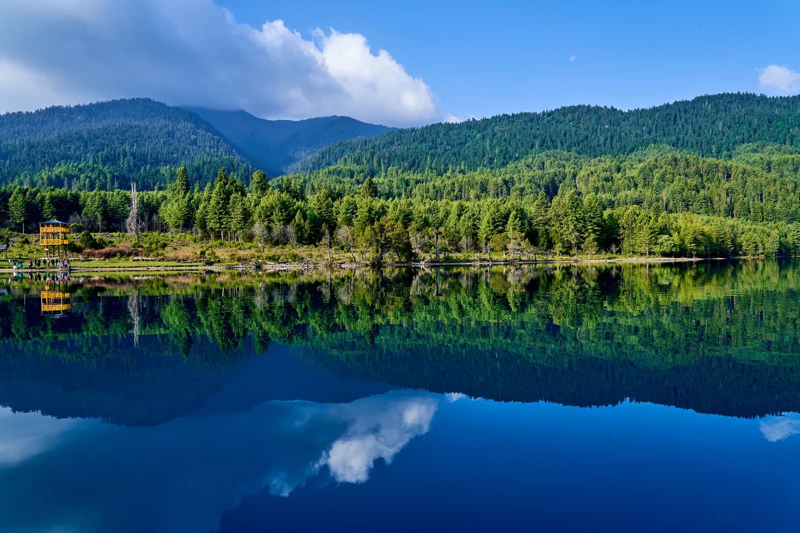
Rara Lake Trek
A 10-day trek from Jumla through Patmara, Chautha and Pina to Rara Lake, Nepal's largest lake, with flights to Jumla and out from Talcha.
- الأيام10
- أقصى ارتفاع3,550 م
- المسافة74.1 كم
- الصعود4,819 م
- الصعوبةمتوسطة
- أفضل الأشهرApr–May, Sep–Nov
- التصاريح2
الصورة: Rawalams · CC BY-SA 4.0
معروض بالإنجليزية — لم يُترجم بعد.
خط السير هذا مسودة ولم يُتحقق منه بعد. أكّد المراحل دائمًا مع مرشدك.
Written by FindTrekkingPartner teamراجعه FindTrekkingPartner teamكيف نراجعFindTrekkingPartner
Rara Lake Trek رحلة ترحال مدتها 10 يومًا في منطقة Rara في نيبال، وتصعد إلى ارتفاع 3,550 م. يمكن للمتجولين الأجانب العثور على شريك لها عبر FindTrekkingPartner بنشر رحلة بتواريخهم وميزانيتهم ووتيرتهم. تبقى المطابقات خاصة حتى يوافق المتجولان معًا، والخدمة مجانية. بالأسعار المتوسطة، يكلف المرشد المرخص نحو 76 دولار أمريكي (USD) للشخص خلال 10 أيام عندما يتشاركه أربعة متجولين، مقابل 302 دولار (USD) لمتجول واحد بمفرده. أفضل المواسم هي Apr–May, Sep–Nov. المرشد المرخص مطلوب عمليًا هنا: تفيد تقارير المشغلين لعام 2026 بأن قاعدة هيئة السياحة النيبالية الصادرة في أبريل 2023 تُطبق عند نقاط التفتيش في المتنزهات الوطنية ومناطق المحميات، وأن لانغتانغ هي الأشد صرامة وأن أنابورنا تتحقق أيضًا (تم التحقق في 19 أكتوبر 2026). استأجر مرشدًا عبر وكالة مسجلة وتأكد معهم. الرحلات المفتوحة لهذا المسار مدرجة أدناه مع شهر البدء وحجم المجموعة والأماكن المتبقية. آخر تحقق: 19 أكتوبر 2026. المصادر: هيئة السياحة النيبالية، DNPWC، إدارة الهجرة.
المصادر:Department of Immigration, NepalNepal Tourism BoardDepartment of National Parks and Wildlife Conservation
ابحث عن شريك لمسار Rara Lake Trek
- ابحث عن شريك لمسار Rara Lake Trekلا توجد رحلات مفتوحة بعد
نظرة عامة
يبدأ من Kathmandu10 يومًا · الأقصى 3,550 م
أفضل المواسم: Apr–May, Sep–Nov · التصاريح: Rara National Park entry permit, TIMS card where required
The Rara Lake trek is a 10-day journey from Jumla to Nepal's largest lake in the far west of the country. It flies from Kathmandu to Nepalgunj and on to Jumla, a hill town at about 2,350 m, then walks for five days through Patmara, Chautha, Pina and Murma to the lake at about 2,990 m, with a rest day on its shore, before a walk to Talcha airstrip and flights back via Nepalgunj. The route covers about 74 km with about 4,800 m of climbing and passes farm villages, terraced fields and pine and rhododendron forest, so it is a moderate trek with long days and no extreme altitude. You need the Rara National Park permit and and a guide is strongly advised. Roads reach Jumla and the lake, and this plan uses the footpaths and shortcuts between them. April, May and September to November are the best months, and flights are weather dependent, so keep spare days.
What the trek is like
From Jumla, the route climbs out of the valley on road and footpath, passing apple orchards and houses of the Karnali region, and crosses forested ridges that reach about 3,500 m. Between the villages it follows paths used by local people for generations, with some sections shared with the rural road. Operator itineraries describe the same approach as Jumla, the Danphe Lagna ridge (about 3,130 m), Chautha (about 2,770 m) and then Dhotu or Pina before the lake, with a first-night stage of about six hours; this plan stops at Patmara, a ridge village at about 3,000 m on that approach, and returns via Talcha instead of Sinja. The final climb to the lake goes through blue pine, spruce and rhododendron forest, and the first view of Rara, a deep blue lake in a basin of forested hills, is the highlight. The lake shore has a few lodges and a viewpoint at Murma, and the walk out to Talcha is gentle.
Highlights
- Rara Lake, about 5 km long and up to 167 m deep, a Ramsar site since 2007
- The viewpoint at Murma above the western shore, at about 3,000 m for the lodges and higher on the ridge
- Rara National Park, Nepal's smallest park, with Himalayan black bear, musk deer and the endemic Rara snow trout
- Jumla and the Khasa Malla history of the Sinja valley
- Quiet footpaths and ridge views of the western Himalaya
Permits and rules
You need the Rara National Park entry permit, issued at the park office or arranged by your agency, and a TIMS card where the local office asks for it. Rara is not a restricted area. The Nepal Tourism Board April 2023 rule requires foreign trekkers to use a licensed guide in national parks and conservation areas, and 2026 operator reports say checkpoints enforce it in Annapurna (ACAP), Langtang (the strictest) and most other parks, but not in Khumbu, where the municipality opted out (checked 19 October 2026). See the guide rule by region. Fees differ for foreigners, SAARC nationals and Nepalis, so ask the agency for current amounts and check them with the park or the Department of National Parks and Wildlife Conservation.
Best season
April and May bring rhododendron and clear mornings, and the lake is calm. September to November are the most popular months, with clear skies and autumn colour above the lake. The monsoon has rain and unreliable flights, and December to February can freeze the lake and close trails with snow. Plan one or two spare days at the end of the trek.
Altitude
Altitude is moderate: Jumla is at about 2,350 m, Patmara about 3,000 m and the lake about 2,990 m. Symptoms are uncommon, but flying straight to Jumla and walking to 3,000 m can cause mild headaches in some people. Go slowly the first day, drink water and use the rest day at the lake. Never ascend with symptoms, and descend if they worsen.
Getting there and away
Fly Kathmandu to Nepalgunj (about an hour) and Nepalgunj to Jumla (about 40 minutes). At the end, fly from Talcha airstrip, about 14 km from Murma by the path or a short jeep ride, to Nepalgunj, and from there to Kathmandu. Flights are weather dependent, and Nepalgunj can be extremely hot. The Karnali Highway links Jumla and Gamgadhi by a rough road, so a jeep is an alternative if flights stop.
Lodges, food and costs
Lodges and homestays are available in Jumla, around Pina and at the lake, but between them there are few options, so many agencies carry tents and a cook for Patmara and Chautha. Meals are dal bhat, noodles and eggs, and the lake lodges may offer local fish and apples. Bring cash for the whole trek.
Packing list
Broken-in boots, waterproof layers, a down jacket, a sleeping bag rated to about minus 10 C, gloves, hat, sunglasses, sun cream, trekking poles, a headlamp, water purification and a first-aid kit. In the monsoon add a rain cover and leech socks.
Who this trek suits and how to prepare
The trek suits fit walkers who want a quiet, lower-altitude trek in a remote region. The days are long, with 15 to 19 km on two of them, so prepare with hill walks and some days with a loaded pack. No technical skills are needed.
The plan at a glance
Days 1 and 2 fly to Nepalgunj and Jumla. Days 3 to 6 walk to Patmara, Chautha, Pina and the lake at Murma. Day 7 is a rest day at Rara. Day 8 walks to Talcha, day 9 flies to Nepalgunj and day 10 flies to Kathmandu.
Extensions
Add a day in Jumla to visit the bazaar, the Chandannath temple and the Sinja valley, or a day for the ridge walk above the lake. For a longer trek, combine Rara with a Phoksundo or Dolpo trek, using Nepalgunj as the hub.
Practical tips from the trail
- Walking times in the day plan are estimates from distance and climb, checked against operator itineraries; real times differ with pace, load and weather.
- Keep spare days for the Talcha and Jumla flights.
- Take rain gear even in autumn, because afternoon showers are common.
- Carry small notes, as villages have limited change.
- Do not swim, wash in or litter the lake.
- Check the route with your guide, since several variants exist between Jumla and the lake.
Responsible trekking
Take rubbish out, use refillable bottles and a filter, keep to the trails and buy from local families. Ask before photographing people, and do not feed wildlife.
أبرز المعالم
- Rara Lake at about 2,990 m, the largest lake in Nepal
- Murma viewpoint above the western shore
- Blue pine, spruce and rhododendron forest in Rara National Park
- Farm villages, apple orchards and old trade paths of the Karnali region
- A quiet trek with few other trekkers
خريطة المسار
بيانات المسار من OpenStreetMap ولم يتحقق منها فريقنا بعد. استخدمها للتخطيط لا للملاحة.
يوماً بيوم
تنام على ارتفاع أعلى بمقدار 2,190 م من الليلة السابقة، متجاوزاً الإرشاد المعتاد البالغ 500 م. خذ وقتك، واشرب كثيراً وراقب الصداع أو الغثيان.
Take the morning flight from Nepalgunj to Jumla, about 40 minutes on a small plane over forested hills and, on clear days, the snow peaks of the far west. Jumla Airport is at about 2,350 m, and the town is known for apples, walnuts and Marsi rice. Meet your crew, check permits, and explore the bazaar and the Chandannath temple if time allows. If the flight is cancelled, you spend another night in Nepalgunj, so plan flexible days. The cool air is a pleasant change.
تنام على ارتفاع أعلى بمقدار 650 م من الليلة السابقة، متجاوزاً الإرشاد المعتاد البالغ 500 م. خذ وقتك، واشرب كثيراً وراقب الصداع أو الغثيان.
A gentle first day from Jumla to Patmara at about 3,000 m, about 10 km with a climb of 950 m, taking 4.5 to 6 hours. The route leaves the valley on rural road and footpath, passing apple orchards and farmhouses, and climbs through fields to a ridge. It shares sections with the road, so keep an eye out for jeeps. Patmara is a hill village with simple lodges or camping. Rest and drink water, because you are above 2,500 m after the flight.
A long walking day from Patmara to Chautha at about 2,770 m, about 19 km with 1,090 m of climbing and 1,320 m of descent, taking 7 to 8 hours. The route crosses forested ridges and farm villages, with views of terraced hillsides and distant peaks, and some sections follow the rural road. Carry lunch and water, because villages are sparse. Chautha has simple lodges or camping fields. Your legs will feel the day, so rest, eat well and keep warm layers handy.
Walk from Chautha to Pina at about 2,370 m, about 11 km with 840 m of climbing and 1,250 m of descent, taking 4.5 to 6 hours. The trail drops through forest and fields to the village of Pina, with views of rice terraces and stone houses. Pina has lodges and shops, and the pace is easy, with time to rest. The air feels warmer after the high ridges. Wash clothes, enjoy a hot meal and prepare for the climb to the lake tomorrow.
تنام على ارتفاع أعلى بمقدار 630 م من الليلة السابقة، متجاوزاً الإرشاد المعتاد البالغ 500 م. خذ وقتك، واشرب كثيراً وراقب الصداع أو الغثيان.
The climb to Rara Lake: from Pina up through blue pine, spruce and rhododendron forest to the Murma area beside the lake at about 3,000 m, about 16 km with 1,300 m of climbing, taking 6.5 to 8 hours. The first view of the lake, a deep blue basin ringed by forested hills, is the highlight. Murma has lodges and a viewpoint on the western shore. Rest, eat well and walk along the shore in the afternoon light. The nights are cold, even in autumn.
A rest day at Rara Lake. Walk the shore path, climb the ridge toward the Murma viewpoint for a wide view of the lake and the Chuchemara ridge, and enjoy the quiet. The lake is about 5 km long and up to 167 m deep, and its colour changes through the day. Look for birds at dawn and dusk and Rara snow trout in the shallows. Do not swim, wash in or litter the lake. Use the afternoon to rest and dry gear.
A walk from Murma to Talcha airstrip at about 2,700 m, about 14 km with 420 m of climbing and 860 m of descent, taking 4.5 to 6 hours, passing the lake's eastern end and the village of Gamgadhi. The route follows paths and rural roads through forest and fields, and ends at the airstrip. Talcha has a few lodges and a small airport office. Check your flight status, pack your bags and keep a spare day in case the weather closes the airstrip.
Fly from Talcha to Nepalgunj, about 40 minutes over foothills and valleys, and transfer to a hotel. The air is hot and humid after the lake, and you may want a shower and a cold drink. If the Kathmandu flight is the same day, you connect at the airport, otherwise rest. Flights from Talcha are often delayed by cloud and wind, so keep a buffer. Your agency will arrange the hotel and onward tickets. Keep your passport and flight tickets within easy reach, and carry a book for the waiting time.
تنام على ارتفاع أعلى بمقدار 1,240 م من الليلة السابقة، متجاوزاً الإرشاد المعتاد البالغ 500 م. خذ وقتك، واشرب كثيراً وراقب الصداع أو الغثيان.
Fly from Nepalgunj to Kathmandu, about an hour, and transfer to your hotel. The flight offers a last view of the Himalaya on clear mornings. Back in Kathmandu, you can shower, repack and explore Thamel or Patan. Keep a spare day after the trek in case of flight delays. Tip your guide and porters according to your agency's guidelines, and celebrate a peaceful journey to Nepal's largest lake in one of its most remote regions. Keep your passport and permit copies in your hand luggage for the airport checks.
التأقلم
ارتفاع المبيت ليلة بعد ليلة. تشير الأعمدة الحمراء إلى صعود يتجاوز 500 م عن الليلة السابقة؛ وأيام الراحة موسومة.
- ارتفاع المبيت
- ارتفاع يتجاوز 500 م
- يوم راحة
التكلفة
التكلفة الشاملة التقديرية للفرد: النزل والطعام حسب الارتفاع، والنقل، والتصاريح، والمرشد والحمّالون. كلما زاد عدد المتنزهين المتقاسمين لمرشد وحمّالين، قلّ ما يدفعه كل فرد. اعتباراً من أكتوبر 2026.
| النمط | متنزه واحد | 2 متنزهين يتقاسمون | 4 متنزهين يتقاسمون |
|---|---|---|---|
| اقتصادي | 630 US$–900 US$ | 630 US$–900 US$ | 630 US$–900 US$ |
| متوسط التكلفة | 930 US$–1,400 US$ | 810 US$–1,200 US$ | 770 US$–1,150 US$ |
| مريح | 1,000 US$–1,500 US$ | 920 US$–1,400 US$ | 890 US$–1,300 US$ |
تقاسم مرشداً ووفّر المال
في الفئة المتوسطة، يدفع المتنزه المنفرد نحو 930 US$–1,400 US$؛ ويدفع أربعة متنزهين يتقاسمون مرشداً وحمّالين اثنين نحو 770 US$–1,150 US$ للفرد (أقل بنسبة 17% في أعلى النطاق).
التفاصيل لمتنزهين يتقاسمان
| البند | اقتصادي | متوسط التكلفة | مريح |
|---|---|---|---|
| النزل والطعام | 200 US$–300 US$ | 260 US$–390 US$ | 330 US$–500 US$ |
| النقل | 400 US$–590 US$ | 400 US$–590 US$ | 400 US$–590 US$ |
| التصاريح | 20 US$–30 US$ | 20 US$–30 US$ | 20 US$–30 US$ |
| المرشد | — | 70 US$–110 US$ | 70 US$–110 US$ |
| الحمّالون | — | 40 US$–80 US$ | 90 US$–160 US$ |
تعتمد الميزانية على النقل العام وبلا حمّال؛ وتتقاسم الفئة المتوسطة حمّالاً واحداً بين متنزهين ومركبة خاصة؛ وتمنح فئة الراحة كل متنزه حمّالاً. يُدرج المرشد حيث يكون مطلوباً أو عندما يكون النمط متوسطاً أو مريحاً.
النزل والطعام لكل ليلة (غرفة ووجبة دال بهات)
4 ليالٍ Below 2,500 m: الغرفة 5 US$–10 US$، دال بهات 5 US$–9 US$ · 5 ليالٍ 2,500 to 3,800 m: الغرفة 5 US$–10 US$، دال بهات 5 US$–9 US$
رسوم التصاريح (مصادر رسمية)
- Rara National Park entry permit: 3,000 NPR لكل دخول المصدر
مصادر التكاليف
- PriceNepal: Nepal Travel Cost Guide 2026 (2026-05-14)
- Third Rock Adventures: Nepal trek budget planner (2026-05-09)
- Himalayan Partner: Guide and porter price in Nepal 2026 (2026-02-10)
- Shikhar Adventure: Annapurna Circuit trek cost (2026-02-03)
- Best Heritage Tour: Rara Lake trek cost (2025-06-18)
تقديرات مستمدة من أدلة المشغلين وليست عروض أسعار. لا تشمل البقشيش والتأمين والمعدات وفنادق كاثماندو؛ الدولار الأمريكي بسعر صرف المنصة.
الصور
الأسئلة الشائعة
Yes, the Rara National Park entry permit. Rara is not a restricted area. Ask your agency for current fees and check them with the park office.
The Nepal Tourism Board April 2023 rule requires foreign trekkers to use a licensed guide in national parks and conservation areas, and 2026 operator reports say checkpoints enforce it in Annapurna (ACAP), Langtang (the strictest) and most other parks, but not in Khumbu, where the municipality opted out (checked 19 October 2026). Confirm with a registered agency. Trails are poorly marked, so a guide is advised.
Ten days from Kathmandu on this plan, including the flights to Jumla and from Talcha, five walking days and a rest day at the lake. Flight delays can add days.
About 2,990 m according to OpenStreetMap and the park, while Wikipedia gives 2,975 m for the lake.
Fly Kathmandu to Nepalgunj and then to Jumla, about 40 minutes. Flights are weather dependent, and the overland alternative takes several days.
April and May, and September to November. The monsoon has rain and unreliable flights, and the lake can freeze from December to February.
Parts of it are. Roads reach Jumla, Gamgadhi and the lake, and the route uses footpaths and shortcuts between them, sharing some sections with the rural road.
المصادر
- Rara Lake Trekking (Himkala Adventure)
- Rara Lake Trek (Peregrine Treks)
- Rara Lake Trek (Marron Treks)
- Rara Lake (Wikipedia)
- Rara National Park (Wikipedia)
- Jumla District (Wikipedia)
- Department of National Parks and Wildlife Conservation, Nepal
- Nepal Tourism Board
- Himalayan Rescue Association
- OpenStreetMap (elevation tags of lakes, airports and villages)
على امتداد المسار
أماكن الإقامة والمساعدة الطبية والمياه والمعالم في كل يوم من المسار.
1. Kathmandu → Nepalgunj
- Tribhuvan International Airport · المطارات والنقل · 1,340 م
Show all 2 places
- Tribhuvan International Airport · المطارات والنقل · 1,340 م
- Nepalgunj Airport · المطارات والنقل · 165 م
2. Nepalgunj → Jumla
لم يُرسم أي شيء لهذا اليوم بعد.لم يُرسم أي شيء لهذا اليوم بعد.3. Jumla → Patmara
- Jumla Airport · المطارات والنقل · 2,347 م
- Kartikswami Ayurveda Center · الخدمات الطبية · 2,372 م
- Chhina Basic Health Post · الخدمات الطبية · 2,342 م
- Hotel Royal Garden · أماكن الإقامة · 2,357 م
- Rawat Hotel · أماكن الإقامة · 2,360 م
- Pauwa · أماكن الإقامة · 2,363 م
Show all 11 places
- Jumla Airport · المطارات والنقل · 2,347 م
- Kartikswami Ayurveda Center · الخدمات الطبية · 2,372 م
- Hotel Royal Garden · أماكن الإقامة · 2,357 م
- Rawat Hotel · أماكن الإقامة · 2,360 م
- Chhina Basic Health Post · الخدمات الطبية · 2,342 م
- Pauwa · أماكن الإقامة · 2,363 م
- Army Helipad · المطارات والنقل · 2,368 م
- Karnali Academy of Health Sciences · الخدمات الطبية · 2,371 م
- Ward 1 Health Post · الخدمات الطبية · 2,387 م
- Ward 3 Health Post · الخدمات الطبية · 2,398 م
- Basic Health Centre Patmara · الخدمات الطبية · 2,820 م
4. Patmara → Chautha
- Bumramadichaur Ilaka health post · الخدمات الطبية · 2,788 م
5. Chautha → Pina
- Ramita Hotel · أماكن الإقامة · 3,189 م
- Ghurchi Lagna · نقاط المشاهدة · 3,452 م
6. Pina → Murma
- Viewpoint · نقاط المشاهدة · 3,064 م
- Help Nepal post · الخدمات الطبية · 2,959 م
- Drinking Water · خدمات عملية · 2,948 م
7. Murma
لم يُرسم أي شيء لهذا اليوم بعد.لم يُرسم أي شيء لهذا اليوم بعد.8. Murma → Talcha
- Murma · أماكن الإقامة · 3,160 م
- Rara Cultural Resort · أماكن الإقامة · 3,021 م
- Drinking Water · خدمات عملية · 2,959 م
- Rara Lake · الطبيعة · 2,990 م
- Chhaynath · أماكن الإقامة · 2,740 م
- Mount Kailash · أماكن الإقامة · 2,740 م
- Viewpoint · نقاط المشاهدة · 2,748 م
Show all 10 places
- Murma · أماكن الإقامة · 3,160 م
- Rara Cultural Resort · أماكن الإقامة · 3,021 م
- Drinking Water · خدمات عملية · 2,959 م
- Danfe Guest House · أماكن الإقامة · 2,990 م
- Rara Lake · الطبيعة · 2,990 م
- Village Heritage · أماكن الإقامة · 3,005 م
- Bhandari Hotel · أماكن الإقامة · 2,714 م
- Viewpoint · نقاط المشاهدة · 2,748 م
- Chhaynath · أماكن الإقامة · 2,740 م
- Mount Kailash · أماكن الإقامة · 2,740 م
9. Talcha → Nepalgunj
- Talcha Airport · المطارات والنقل · 2,731 م
10. Nepalgunj → Kathmandu
لم يُرسم أي شيء لهذا اليوم بعد.لم يُرسم أي شيء لهذا اليوم بعد.
آخر تحقق في 19/10/2026الإبلاغ عن معلومات قديمة