

Drive from Kathmandu to Besisahar, the headquarters of Lamjung District at about 760 m, about 6 to 7 hours along the Prithvi Highway and the Marsyangdi valley, with views of terraced hills and rivers. Besisahar is the traditional start of the Annapurna Circuit and has hotels and shops. Check your permits with your guide, buy any last supplies and rest. The jeep road continues tomorrow into the mountains. If the road is blocked by landslides, you may need a spare day. Buy snacks and cash before leaving the city.
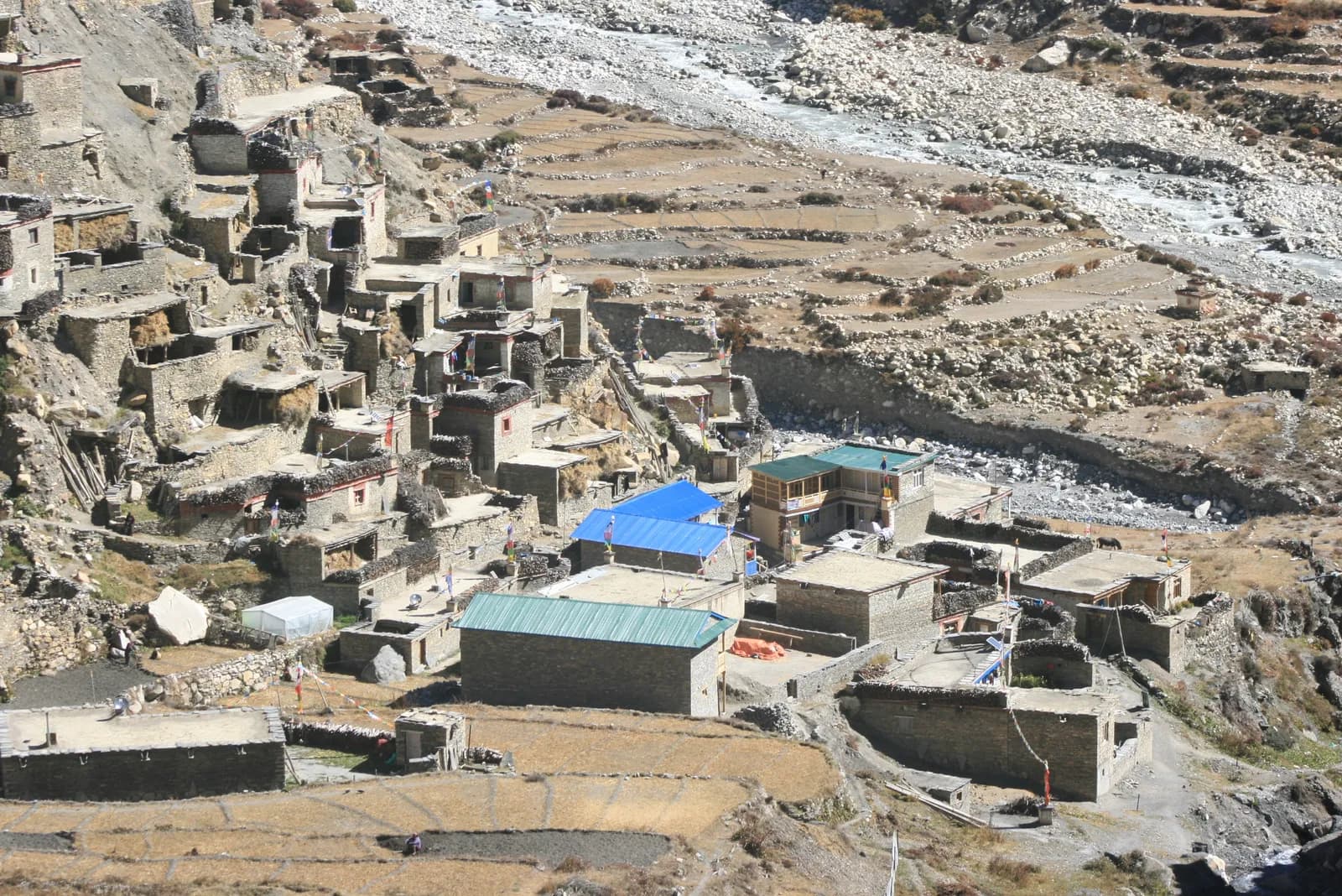
Nar Phu Valley Trek
An 11-day restricted-area loop from Koto up the Nar Phu gorge to Phu and Nar, over the Kang La at about 5,300 m to Ngawal, with road access from Besisahar.
- الأيام11
- أقصى ارتفاع5,306 م
- المسافة82.4 كم
- الصعود7,075 م
- الصعوبةصعبة
- أفضل الأشهرSep–Nov, Mar–May
- التصاريح3
الصورة: Sharadgurung7711 · CC BY-SA 4.0
معروض بالإنجليزية — لم يُترجم بعد.
خط السير هذا مسودة ولم يُتحقق منه بعد. أكّد المراحل دائمًا مع مرشدك.
Written by FindTrekkingPartner teamراجعه FindTrekkingPartner teamكيف نراجعFindTrekkingPartner
Nar Phu Valley Trek رحلة ترحال مدتها 11 يومًا في منطقة Annapurna في نيبال، وتصعد إلى ارتفاع 5,306 م. يمكن للمتجولين الأجانب العثور على شريك لها عبر FindTrekkingPartner بنشر رحلة بتواريخهم وميزانيتهم ووتيرتهم. تبقى المطابقات خاصة حتى يوافق المتجولان معًا، والخدمة مجانية. بالأسعار المتوسطة، يكلف المرشد المرخص نحو 69 دولار أمريكي (USD) للشخص خلال 11 أيام عندما يتشاركه أربعة متجولين، مقابل 275 دولار (USD) لمتجول واحد بمفرده. أفضل المواسم هي Mar–May, Oct–Nov. المرشد المرخص مطلوب عمليًا هنا: تفيد تقارير المشغلين لعام 2026 بأن قاعدة هيئة السياحة النيبالية الصادرة في أبريل 2023 تُطبق عند نقاط التفتيش في المتنزهات الوطنية ومناطق المحميات، وأن لانغتانغ هي الأشد صرامة وأن أنابورنا تتحقق أيضًا (تم التحقق في 19 أكتوبر 2026). استأجر مرشدًا عبر وكالة مسجلة وتأكد معهم. آخر تحقق: 21 أكتوبر 2026. المصادر: هيئة السياحة النيبالية، DNPWC، إدارة الهجرة.
المصادر:Department of Immigration, NepalNepal Tourism BoardDepartment of National Parks and Wildlife Conservation
ابحث عن شريك لمسار Nar Phu Valley Trek
- ابحث عن شريك لمسار Nar Phu Valley Trekلا توجد رحلات مفتوحة بعد
- ابحث عن شريك لمسار Annapurna Base Camp Trek25 رحلة مفتوحة
- ابحث عن شريك لمسار Annapurna Circuit Trek4 رحلات مفتوحة
- ابحث عن شريك لمسار Poon Hill Trek (Ghorepani)3 رحلات مفتوحة
- ابحث عن شريك لمسار Tilicho Lake Trek4 رحلات مفتوحة
- ابحث عن شريك لمسار Mardi Himal Trek27 رحلة مفتوحة
نظرة عامة
يبدأ من Kathmanduالممرات: Kang La11 يومًا · الأقصى 5,306 م
أفضل المواسم: Sep–Nov, Mar–May · التصاريح: Nar Phu restricted area permit (Department of Immigration, via a registered agency), Annapurna Conservation Area entry permit, TIMS card where required
The Nar Phu Valley trek is an 11-day loop through a remote restricted valley on the north side of the Annapurna range, in Manang District. It drives from Kathmandu to Besisahar and on to Koto, climbs through the Nar Phu gorge to Meta, Kyang and Phu, crosses to Nar, and returns over the Kang La at about 5,306 m to Ngawal and Manang, before the drive back. The route covers about 82 km on foot with large daily climbs and a gain of about 7,000 m according to the elevation model, so it is a hard trek. The valley is a restricted area inside the Annapurna Conservation Area, so you need a Restricted Area Permit through a registered agency, the conservation area permit and a licensed guide. The best months are September to November, and March to May. It suits fit trekkers who want Tibetan culture and a quiet valley and can handle a high pass.
What the trek is like
The trail leaves the Marsyangdi valley at Koto and enters a steep gorge of cliffs and pine forest, crossing bridges high above the Nar Phu Khola. After Meta the valley opens, and the villages of Kyang and Phu appear, with stone houses, chortens and fields at about 4,100 m. Phu has an old monastery and a view of Himlung Himal. The trail then crosses to Nar, a larger village with a gompa, and climbs to the Kang La, from which views of the Annapurna range open. The descent to Ngawal reaches the main Annapurna Circuit trail, and the last day follows it to Manang.
Highlights
- Phu village and Phu Gompa, with old Tibetan-style houses and chortens
- Nar village and its monastery
- The Nar Phu gorge, a deep, narrow canyon of cliffs and waterfalls
- The Kang La, with views of Annapurna II, Annapurna IV and Gangapurna
- Blue sheep, and possible snow leopard signs on the high slopes
Permits and rules
The Nar Phu valley is a restricted area. You need a Restricted Area Permit from the Department of Immigration, issued through a registered agency, an Annapurna Conservation Area entry permit and a TIMS card where required. A licensed guide must accompany you. Reports of a March 2026 notice say individual foreigners may apply, but the permit still needs an agency and a guide. Fees and day counts have changed more than once, so ask the agency for the current amounts and check them with the Department of Immigration. Carry several copies of your passport and permits for check posts.
Best season
September to November have the clearest weather, and March to May are possible, but the Kang La may hold snow in early spring. The monsoon is wetter on the south side and quieter in this rain-shadow valley, but landslides can block the road. Winter is very cold, with heavy snow on the pass.
Altitude
The plan sleeps at Meta (about 3,560 m), Phu (about 4,080 m, with a rest day) and Nar (about 4,110 m, with a rest day), before the Kang La at about 5,306 m. The pass day gains about 1,100 m and descends about 1,600 m, so it is long and tiring. Watch for headache, nausea and poor sleep, never ascend with symptoms, and descend if they worsen. Discuss altitude medicine with your doctor.
Getting there and away
Drive from Kathmandu to Besisahar (6 to 7 hours) and continue by jeep along the Marsyangdi road to Koto, about 6 to 7 hours more. The return from Manang to Besisahar by jeep takes 8 to 9 hours on a rough road, followed by the drive to Kathmandu. Landslides can cause delays, so keep a spare day.
Lodges, food and costs
Simple lodges and homestays operate in Meta, Kyang, Phu and Nar, with dal bhat, noodles, tsampa and tea. Facilities are basic, and some agencies carry tents and a cook for flexibility. Prices rise with altitude, and you should bring cash for the whole trek, because there are no machines beyond Besisahar and Manang.
Packing list
Broken-in boots, waterproof layers, a down jacket, a sleeping bag rated to about minus 15 C, gloves, hat, sunglasses, sun cream, gaiters, trekking poles, a headlamp, water purification and a first-aid kit. A pair of microspikes can help on the Kang La if snow lies.
Who this trek suits and how to prepare
The trek suits fit trekkers who like culture and remote valleys and are comfortable with long days at altitude. Prepare with hill walks, stair training and some days with a loaded pack. The pass day of about 15 km needs good stamina.
The plan at a glance
Days 1 and 2 drive to Besisahar and Koto. Days 3 and 4 walk to Meta and Phu, with a rest day on day 5. Day 6 walks to Nar and day 7 is a rest day. Day 8 crosses the Kang La to Ngawal and day 9 walks to Manang. Days 10 and 11 drive to Besisahar and Kathmandu.
Extensions
From Manang you can continue over the Thorong La to Muktinath and Jomsom on the Annapurna Circuit, which adds about a week. Others add a side trip to Tilicho Lake or a day at Manang, or combine the trek with a short stay in Pokhara.
Practical tips from the trail
- Walking times in the day plan are estimates from distance and climb, checked against operator itineraries; real times differ with pace, load and weather.
- Start early on the Kang La day, with food, water and warm layers.
- Check the snow with your guide before leaving Nar.
- Keep a spare day for the Marsyangdi road.
- Respect monasteries and walk clockwise around chortens.
- Carry cash in small notes, as villages have no machines.
Responsible trekking
Take rubbish out, use filtered water, buy from local families and respect the valley's customs. Do not give sweets or money to children.
أبرز المعالم
- Phu and Nar, Tibetan-style villages at about 4,100 m in a restricted valley
- The Nar Phu gorge, with cliffs, suspension bridges and waterfalls
- The Kang La at about 5,306 m, with views of the Annapurna range
- Phu Gompa and old stone houses and chortens
- A quiet, remote alternative to the Annapurna Circuit
خريطة المسار
بيانات المسار من OpenStreetMap ولم يتحقق منها فريقنا بعد. استخدمها للتخطيط لا للملاحة.
يوماً بيوم
تنام على ارتفاع أعلى بمقدار 1,840 م من الليلة السابقة، متجاوزاً الإرشاد المعتاد البالغ 500 م. خذ وقتك، واشرب كثيراً وراقب الصداع أو الغثيان.
Continue by jeep from Besisahar up the Marsyangdi valley to Koto at about 2,600 m, about 6 to 7 hours on a rough road, passing Syange, Tal, Dharapani and Chame as the scenery turns from subtropical to alpine. Koto is a small village near the junction of the Nar Phu Khola and the entrance to the restricted valley, with a checkpost where your permits are inspected. Spend the afternoon resting and preparing, because the trail begins tomorrow. The air is cool. Keep a warm layer handy because the valley is cooler than Besisahar.
تنام على ارتفاع أعلى بمقدار 960 م من الليلة السابقة، متجاوزاً الإرشاد المعتاد البالغ 500 م. خذ وقتك، واشرب كثيراً وراقب الصداع أو الغثيان.
A long first walking day from Koto to Meta at about 3,560 m, about 16 km, taking 8 to 9 hours. The trail enters the Nar Phu gorge, climbing and dropping along cliffs above the river on narrow paths and bridges, with pine forest and waterfalls. The elevation model shows large ups and downs in the gorge. Carry lunch and water, and keep a steady pace. Meta is a small village of stone houses where you spend the night. Drink water regularly and avoid walking directly under loose rock.
تنام على ارتفاع أعلى بمقدار 520 م من الليلة السابقة، متجاوزاً الإرشاد المعتاد البالغ 500 م. خذ وقتك، واشرب كثيراً وراقب الصداع أو الغثيان.
Walk from Meta to Phu at about 4,080 m via Kyang, about 18 km with a climb of 1,200 m, taking 7 to 8 hours. The valley opens as you leave the forest, with views of cliffs, chortens and the first Tibetan-style stone houses. Kyang is a seasonal herders' settlement, and Phu is a village on a terrace with an old monastery and a view of Himlung Himal. Watch for symptoms of altitude sickness, drink plenty of water and rest early. Pace yourself, because the altitude is the highest of the trek so far.
A rest and acclimatisation day at Phu. Visit Phu Gompa and walk through the village's lanes of stone houses and chortens, taking an easy hike up the valley toward the Himlung Himal base camp trail, returning by the afternoon. The aim is to sleep at the same height as the day before, and to let your body adapt. Respect the monastery, ask before taking photographs and walk clockwise around the chortens. Rest, eat well and drink water. Use the quiet day to dry gear and check your pass plan.
Walk from Phu to Nar at about 4,110 m, about 21 km with 1,400 m of climbing and 1,270 m of descent, taking 8 to 10 hours. The trail follows the valley back to the junction below Phu, then climbs on a high path to Nar, a larger village with a gompa and stone houses. It is a long day, so carry lunch and water, and keep a steady pace. The views of cliffs and peaks are fine, and Nar's lodges are welcome after the long walk.
A rest day at Nar. Walk through the village and visit the gompa, then take an easy hike up the slopes toward the Kang La base for views of the valley and the Annapurna range, returning by the afternoon. The aim is to rest and let your body adapt before the pass. Check your gear, charge power banks if the lodge has solar power and talk to your guide about the weather and snow on the Kang La. Eat well and drink water.
The pass day. From Nar climb to the Kang La at about 5,306 m and descend to Ngawal at about 3,660 m, about 15 km with 1,100 m of climbing and 1,630 m of descent, taking 6 to 8 hours or more. Start before dawn, carry lunch, water and warm layers, and move steadily. The pass has views of Annapurna II, Annapurna IV and Gangapurna, and the descent is steep and long. Ngawal sits on the main Annapurna trail. Rest and eat well.
A short walk from Ngawal to Manang at about 3,540 m via Humde, about 12 km, taking 3.5 to 5 hours. The route joins the Annapurna Circuit trail, passing Humde and the airstrip, with views of the Annapurna range and Gangapurna Lake. Manang is a busy village with bakeries, shops, a Himalayan Rescue Association aid post and lodges. Use the afternoon to rest, shower, wash clothes and enjoy a bakery treat. You may meet Annapurna Circuit trekkers. Keep your passport and permit copies in your hand luggage.
Drive from Manang to Besisahar, about 8 to 9 hours by jeep on a rough road down the Marsyangdi valley, passing Chame, Dharapani and Syange. The scenery changes from alpine to subtropical as you descend. Leave early and carry water and snacks, because the road can be slow in places and landslides can cause delays. Besisahar has hotels, hot showers and restaurants, a welcome change after the trek. Rest and celebrate your crossing. Keep a warm layer for the cooler early morning start.
تنام على ارتفاع أعلى بمقدار 640 م من الليلة السابقة، متجاوزاً الإرشاد المعتاد البالغ 500 م. خذ وقتك، واشرب كثيراً وراقب الصداع أو الغثيان.
Drive from Besisahar to Kathmandu, about 6 to 7 hours along the Marsyangdi valley and the Prithvi Highway. Leave early to arrive in the afternoon, and keep a spare day in the schedule in case landslides block the road. Back in the hotel, shower, repack and celebrate with a good dinner. Tip your guide and porters according to your agency's guidelines, and enjoy the memory of a trek through one of Nepal's most remote and culturally rich valleys. Keep your passport and permit copies in your hand luggage.
التأقلم
ارتفاع المبيت ليلة بعد ليلة. تشير الأعمدة الحمراء إلى صعود يتجاوز 500 م عن الليلة السابقة؛ وأيام الراحة موسومة.
- ارتفاع المبيت
- ارتفاع يتجاوز 500 م
- يوم راحة
التكلفة
التكلفة الشاملة التقديرية للفرد: النزل والطعام حسب الارتفاع، والنقل، والتصاريح، والمرشد والحمّالون. كلما زاد عدد المتنزهين المتقاسمين لمرشد وحمّالين، قلّ ما يدفعه كل فرد. اعتباراً من أكتوبر 2026.
| النمط | متنزه واحد | 2 متنزهين يتقاسمون | 4 متنزهين يتقاسمون |
|---|---|---|---|
| اقتصادي | 650 US$–900 US$* | 540 US$–740 US$* | 490 US$–660 US$* |
| متوسط التكلفة | 1,100 US$–1,600 US$* | 790 US$–1,100 US$* | 650 US$–910 US$* |
| مريح | 1,150 US$–1,700 US$* | 920 US$–1,300 US$* | 790 US$–1,100 US$* |
تقاسم مرشداً ووفّر المال
في الفئة المتوسطة، يدفع المتنزه المنفرد نحو 1,100 US$–1,600 US$؛ ويدفع أربعة متنزهين يتقاسمون مرشداً وحمّالين اثنين نحو 650 US$–910 US$ للفرد (أقل بنسبة 42% في أعلى النطاق).
التفاصيل لمتنزهين يتقاسمان
| البند | اقتصادي | متوسط التكلفة | مريح |
|---|---|---|---|
| النزل والطعام | 280 US$–380 US$ | 340 US$–480 US$ | 420 US$–580 US$ |
| النقل | 10 US$–50 US$ | 140 US$–230 US$ | 140 US$–230 US$ |
| التصاريح | 120 US$–160 US$ | 120 US$–160 US$ | 120 US$–160 US$ |
| المرشد | 110 US$–170 US$ | 110 US$–170 US$ | 110 US$–170 US$ |
| الحمّالون | — | 50 US$–90 US$ | 100 US$–180 US$ |
تعتمد الميزانية على النقل العام وبلا حمّال؛ وتتقاسم الفئة المتوسطة حمّالاً واحداً بين متنزهين ومركبة خاصة؛ وتمنح فئة الراحة كل متنزه حمّالاً. يُدرج المرشد حيث يكون مطلوباً أو عندما يكون النمط متوسطاً أو مريحاً.
النزل والطعام لكل ليلة (غرفة ووجبة دال بهات)
2 ليالٍ Below 2,500 m: الغرفة 2 US$–6 US$، دال بهات 4 US$–7 US$ · 4 ليالٍ 2,500 to 3,800 m: الغرفة 4 US$–9 US$، دال بهات 5 US$–9 US$ · 4 ليالٍ Above 3,800 m: الغرفة 10 US$–15 US$، دال بهات 10 US$–12 US$
رسوم التصاريح (مصادر رسمية)
غير مشمول
لم نجد سعراً منشوراً لـ: Besisahar to Koto and Manang to Besisahar jeeps. الإجماليات المعلّمة بـ * لا تشمل هذه البنود؛ اسأل وكالتك.
مصادر التكاليف
- PriceNepal: Nepal Travel Cost Guide 2026 (2026-05-14)
- Third Rock Adventures: Nepal trek budget planner (2026-05-09)
- Himalayan Partner: Guide and porter price in Nepal 2026 (2026-02-10)
- Shikhar Adventure: Annapurna Circuit trek cost (2026-02-03)
تقديرات مستمدة من أدلة المشغلين وليست عروض أسعار. لا تشمل البقشيش والتأمين والمعدات وفنادق كاثماندو؛ الدولار الأمريكي بسعر صرف المنصة.
الصور
الأسئلة الشائعة
Yes, a Restricted Area Permit from the Department of Immigration through a registered agency, plus the Annapurna Conservation Area permit and a TIMS card where required. Ask for current fees.
No. A licensed guide is compulsory in the restricted area. Reports say that since March 2026 individuals may apply for the permit, but a registered agency and guide are still required.
Eleven days from Kathmandu on this plan, including two driving days at each end, two rest days and the Kang La crossing. Many agencies allow 12 to 14 days.
About 5,306 m, according to OpenStreetMap. Guides often quote 5,320 m.
September to November, and March to May. The Kang La can hold snow in early spring, and winter is very cold.
Yes. From Manang you can continue over the Thorong La, which adds about a week and needs the ACAP permit, which you already hold.
Hard. The gorge trail has steep ups and downs, the days are long, and the Kang La is a high pass above 5,300 m.
المصادر
- Nar Phu Valley Trek, 10 days (Himalayan Local Guide)
- Nar Phu Valley Trek itinerary (Trekking in Nepal)
- Annapurna Conservation Area (Wikipedia)
- Manang District (Wikipedia)
- Department of Immigration, Nepal
- Restrictions on trekking for foreigners in controlled areas of 13 districts (Kantipur, 6 May 2026)
- Nepal Tourism Board
- Himalayan Rescue Association
- OpenStreetMap (elevation tags of passes, villages and peaks)
على امتداد المسار
أماكن الإقامة والمساعدة الطبية والمياه والمعالم في كل يوم من المسار.
1. Kathmandu → Besisahar
- Tribhuvan International Airport · المطارات والنقل · 1,340 م
2. Besisahar → Koto
لم يُرسم أي شيء لهذا اليوم بعد.لم يُرسم أي شيء لهذا اليوم بعد.3. Koto → Meta
- Drinking Water · خدمات عملية · 2,891 م
- Chomcho Gufa Hotel · أماكن الإقامة · 3,190 م
- Mayta Guest House and restaraunt · أماكن الإقامة · 3,621 م
- Hotel Narpa · أماكن الإقامة · 3,640 م
- TERELHA Guest House & Restaurant · أماكن الإقامة · 3,626 م
Show all 6 places
- Drinking Water · خدمات عملية · 2,891 م
- Chomcho Gufa Hotel · أماكن الإقامة · 3,190 م
- Himalayan Yak Hotel &Restaurant · أماكن الإقامة · 3,466 م
- Mayta Guest House and restaraunt · أماكن الإقامة · 3,621 م
- Hotel Narpa · أماكن الإقامة · 3,640 م
- TERELHA Guest House & Restaurant · أماكن الإقامة · 3,626 م
4. Meta → Phu
- Zambala Guest House Restaurant · أماكن الإقامة · 3,611 م
- Buddha Guest House & Restaurant · أماكن الإقامة · 3,785 م
- Hôtel Lama · أماكن الإقامة · 4,021 م
- Viewpoint · نقاط المشاهدة · 4,095 م
- Karsang Lodge · أماكن الإقامة · 4,066 م
Show all 9 places
- Zambala Guest House Restaurant · أماكن الإقامة · 3,611 م
- Buddha Guest House & Restaurant · أماكن الإقامة · 3,785 م
- Dikey Restaurant · أماكن الإقامة · 3,802 م
- Karma hotel · أماكن الإقامة · 3,814 م
- Chyakhu Guest House e Restaurant · أماكن الإقامة · 3,817 م
- Hotel · أماكن الإقامة · 3,875 م
- Hôtel Lama · أماكن الإقامة · 4,021 م
- Viewpoint · نقاط المشاهدة · 4,095 م
- Karsang Lodge · أماكن الإقامة · 4,066 م
5. Phu
لم يُرسم أي شيء لهذا اليوم بعد.لم يُرسم أي شيء لهذا اليوم بعد.6. Phu → Nar
- Phu Mountain Lodge · أماكن الإقامة · 4,063 م
- Shanti Hotel & Restaurant · أماكن الإقامة · 4,219 م
- Laxmi Hotel · أماكن الإقامة · 4,204 م
- Diki Ling Hotel · أماكن الإقامة · 4,210 م
Show all 8 places
- Phu Mountain Lodge · أماكن الإقامة · 4,063 م
- Tashi Delek Hotel · أماكن الإقامة · 3,873 م
- Chyakhu Guest House · أماكن الإقامة · 3,799 م
- Monastery · أماكن الإقامة · 3,547 م
- Gulung Teahouse · أماكن الإقامة · 3,870 م
- Shanti Hotel & Restaurant · أماكن الإقامة · 4,219 م
- Laxmi Hotel · أماكن الإقامة · 4,204 م
- Diki Ling Hotel · أماكن الإقامة · 4,210 م
7. Nar
لم يُرسم أي شيء لهذا اليوم بعد.لم يُرسم أي شيء لهذا اليوم بعد.8. Nar → Ngawal
- Drinking Water · خدمات عملية · 4,364 م
- Shanti Hotel · أماكن الإقامة · 3,675 م
- Ngawal · أماكن الإقامة · 3,673 م
- Tibet Guest House & Restaurant · أماكن الإقامة · 3,671 م
9. Ngawal → Manang
- ACAP Safe Drinking Water Station · خدمات عملية · 3,394 م
- Hotel Mountain Lake · أماكن الإقامة · 3,537 م
- HRA Manang Aid Post · الخدمات الطبية · 3,540 م
- Tilicho Hotel & Restaurant · أماكن الإقامة · 3,538 م
- Safe Drinking Water Station · خدمات عملية · 3,550 م
- Hotel Marsyangdi · أماكن الإقامة · 3,545 م
- Moon Light Hotel & Restaurant · أماكن الإقامة · 3,550 م
- Manang Health Post · الخدمات الطبية · 3,558 م
Show all 27 places
- Buddha Kitchen Hotel · أماكن الإقامة · 3,658 م
- Royal Nyeshyang · أماكن الإقامة · 3,655 م
- Manang Airport · المطارات والنقل · 3,353 م
- ACAP Safe Drinking Water Station · خدمات عملية · 3,394 م
- Shanta Hotel · أماكن الإقامة · 3,396 م
- Viewpoint · نقاط المشاهدة · 3,454 م
- Small lake · الطبيعة · 3,437 م
- Munji Lodge & Bakery · أماكن الإقامة · 3,470 م
- Munji lodge · أماكن الإقامة · 3,471 م
- Hotel New Yak · أماكن الإقامة · 3,472 م
- Hotel Buddha & peace cafe · أماكن الإقامة · 3,473 م
- Himalayan lodge · أماكن الإقامة · 3,474 م
- Namaste trekkers homestay · أماكن الإقامة · 3,485 م
- Hotel Mountain Lake · أماكن الإقامة · 3,537 م
- HRA Manang Aid Post · الخدمات الطبية · 3,540 م
- Tilicho Hotel & Restaurant · أماكن الإقامة · 3,538 م
- Safe Drinking Water Station · خدمات عملية · 3,550 م
- Hotel Marsyangdi · أماكن الإقامة · 3,545 م
- Moon Light Hotel & Restaurant · أماكن الإقامة · 3,550 م
- Yak Hotel · أماكن الإقامة · 3,544 م
- Moon Light hotel · أماكن الإقامة · 3,550 م
- Alpine home · أماكن الإقامة · 3,544 م
- Hotel North Pole · أماكن الإقامة · 3,550 م
- Gangapurna Hotel Lodge · أماكن الإقامة · 3,543 م
- Manang Health Post · الخدمات الطبية · 3,558 م
- Ghyalchan & Sister · أماكن الإقامة · 3,543 م
- Ghale guest house · أماكن الإقامة · 3,544 م
10. Manang → Besisahar
لم يُرسم أي شيء لهذا اليوم بعد.لم يُرسم أي شيء لهذا اليوم بعد.11. Besisahar → Kathmandu
لم يُرسم أي شيء لهذا اليوم بعد.لم يُرسم أي شيء لهذا اليوم بعد.
آخر تحقق في 21/10/2026الإبلاغ عن معلومات قديمة