

Drive from Kathmandu east to Charikot and Singati, then north along the Tamakoshi and Rolwaling rivers to Chetchet, the roadhead at about 1,410 m. The drive takes 8 to 9 hours in a jeep, with a rough, muddy last stretch, passing terraced hills, small bazaars and views of the Gauri Shankar range on a clear day. The road is often blocked by landslides in the monsoon, so keep a spare day. Chetchet is a small village with simple lodges, and you spend the night here.
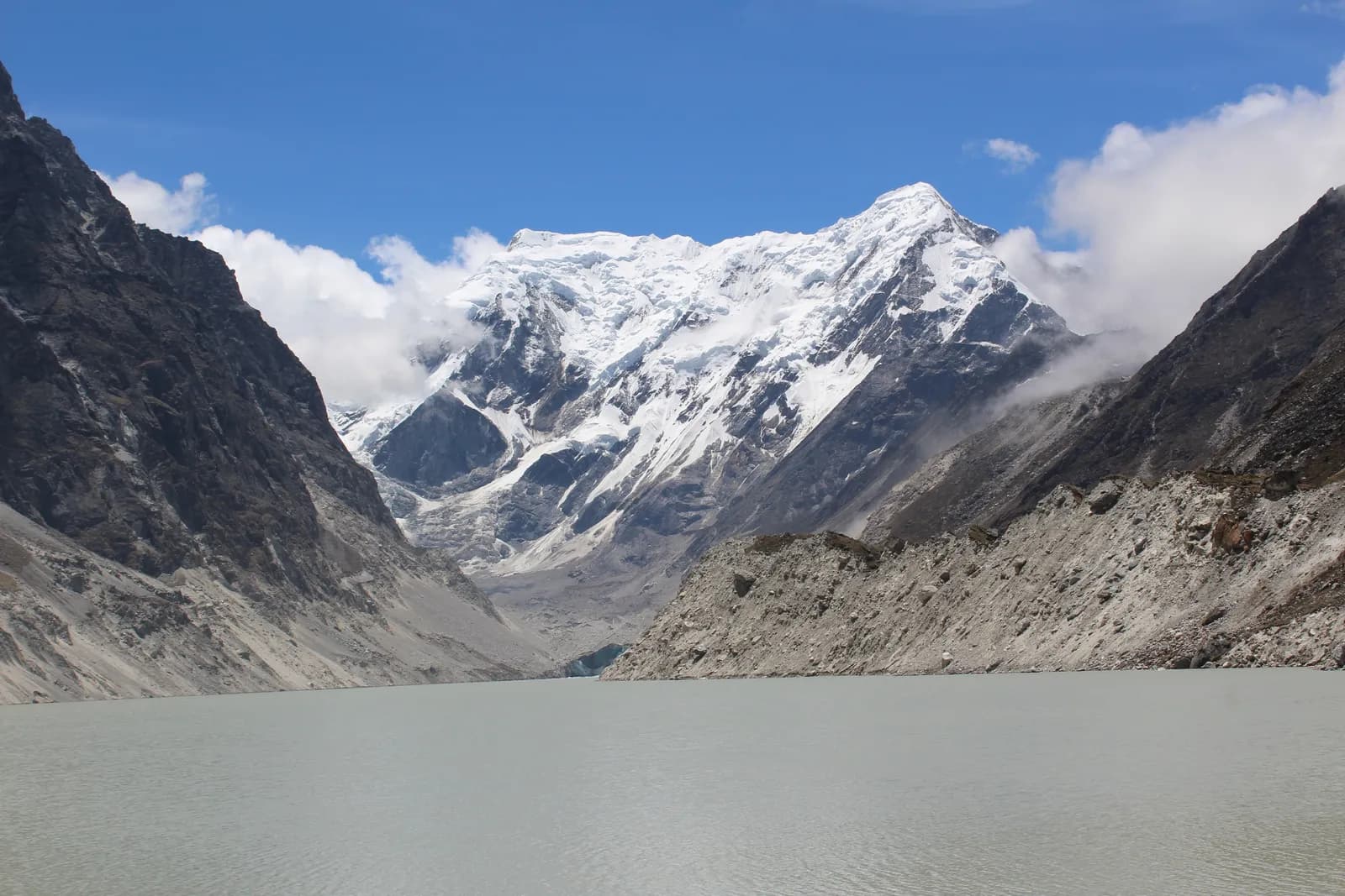
Rolwaling and Tsho Rolpa Trek
An 11-day road-access trek up the Rolwaling valley from Chetchet through Simigaon, Dongang, Beding and Na to Tsho Rolpa, a glacial lake at about 4,580 m under Gaurishankar.
- 天數11
- 最高海拔4,580 公尺
- 距離64.2 公里
- 爬升3,847 公尺
- 難度困難
- 最佳月份Mar–May, Oct–Nov
- 許可2
照片:Hrishav398 · CC BY-SA 4.0
以英文顯示——尚未翻譯。
此行程為草稿,尚未經過確認。請務必與你的嚮導確認各段行程。
Written by FindTrekkingPartner team審閱者:FindTrekkingPartner team我們如何審閱FindTrekkingPartner
Rolwaling and Tsho Rolpa Trek是位於尼泊爾Rolwaling地區的 11 天健行路線,最高海拔達 4,580 公尺。外國健行者可以在 FindTrekkingPartner 發布行程,填入日期、預算與步調,為這條路線尋找夥伴。在雙方健行者都同意之前,配對結果會保持私密,且服務完全免費。 以中等價位計算,四位健行者共用時,持照嚮導 11 天的費用約為每人 90 美元(USD),一人獨自健行則為 361 美元(USD)。最佳季節為Mar–May, Oct–Nov。 這裡實務上需要持照嚮導:據 2026 年業者回報,尼泊爾旅遊局 2023 年 4 月的規定在國家公園與保護區的檢查哨會被執行,其中朗塘(Langtang)最嚴格,安納布爾納(Annapurna)也會查驗(2026 年 10 月 19 日查證)。請透過登記代理商聘請嚮導,並向他們確認。 這條路線的開放行程列於下方,附有出發月份、團隊人數與剩餘名額。 最後查證日期:2026年10月19日。資料來源:尼泊爾旅遊局(Nepal Tourism Board)、DNPWC、移民局。
資料來源:Department of Immigration, NepalNepal Tourism BoardDepartment of National Parks and Wildlife Conservation
尋找Rolwaling and Tsho Rolpa Trek的夥伴
概覽
從 Kathmandu 出發11 天 · 最高 4,580 公尺
最佳季節:Mar–May, Oct–Nov · 許可:Gaurishankar Conservation Area entry permit, TIMS card where required
The Rolwaling and Tsho Rolpa trek is an 11-day journey up a hidden Sherpa valley in Dolakha District, east of Langtang, to one of Nepal's largest glacial lakes at about 4,580 m. It drives from Kathmandu to Chetchet in a day, climbs to Simigaon, Dongang and Beding, rests at Beding, continues to Na for a day trip to Tsho Rolpa under the pyramid of Gaurishankar, 7,134 m, and returns by the same trail before the drive back. The route covers about 64 km on foot, with about 3,850 m of climbing, and sleeps up to about 4,190 m at Na. The valley lies in the Gaurishankar Conservation Area, so you need the conservation area permit and and a guide is strongly advised, but no restricted-area permit. The trek is hard because of steep trails and altitude, and the best months are October and November, and March to May. It suits fit trekkers who want a quiet valley close to Kathmandu.
What the trek is like
The trail starts above the Tamakoshi and Rolwaling rivers at Chetchet, then climbs steeply through terraces and forest to Simigaon, the first Sherpa village. From there it follows the Rolwaling Khola through rhododendron, oak and fir forest, crossing the river on bridges, to Dongang and then up to Beding, a village of stone houses and yak pastures on an open terrace. Above Beding the valley widens into meadows and moraine, and Na is a seasonal settlement at the foot of the lake trail. The lake itself sits behind a moraine dam, with the glacier and the peaks of the Rolwaling Himal behind it.
Highlights
- Tsho Rolpa, a glacial lake about 4,580 m high in the Rolwaling Valley
- Views of Gaurishankar, Menlungtse and the Rolwaling Himal from Beding and Na
- Simigaon and Beding, Sherpa villages with gompas and mani walls
- Rhododendron and fir forest, with chances of red panda and Himalayan tahr
- A trek that starts and ends with a road drive, with no flights
Permits and rules
You need a Gaurishankar Conservation Area entry permit, bought through your agency or at the checkpoint, and a TIMS card where the local office asks for it. Rolwaling is not a restricted area. The Nepal Tourism Board April 2023 rule requires foreign trekkers to use a licensed guide in national parks and conservation areas, and 2026 operator reports say checkpoints enforce it in Annapurna (ACAP), Langtang (the strictest) and most other parks, but not in Khumbu, where the municipality opted out (checked 19 October 2026). See the guide rule by region. Fees differ for foreigners, SAARC nationals and Nepalis, so ask for current amounts and check them with the National Trust for Nature Conservation or the Department of National Parks and Wildlife Conservation.
Best season
October and November are the best months, with stable weather and clear views. March to May bring rhododendron, though snow can linger above Beding early in spring. The monsoon has leeches, landslides and cloud, and December to February are very cold with snow above Dongang. Allow a spare day for the road.
Altitude
The plan climbs from Chetchet at about 1,410 m to Simigaon (about 1,970 m), Dongang (about 2,790 m) and Beding (about 3,710 m), then to Na (about 4,190 m), with a rest day at Beding and a day trip to the lake at about 4,580 m. The gain from Dongang to Beding is about 1,050 m in one day, so go slowly. Watch for headache, nausea and poor sleep, never ascend with symptoms, and descend if they worsen. Discuss altitude medicine with your doctor.
Getting there and away
Drive from Kathmandu via Charikot and Singati to Chetchet, about 8 to 9 hours in a jeep, with a rough last section. The road is prone to landslides in the monsoon, and in some years it ends at Singati, adding days. The return is the same drive on the last day. There are no flights, and a spare day for the road is wise.
Lodges, food and costs
Simple lodges and homestays operate at Chetchet, Simigaon, Dongang, Beding and Na, with dal bhat, noodles, potatoes and tea. Rooms are basic, with blankets, and during busy periods some groups camp at Na. Prices rise with altitude, and you should bring cash for the whole trek, because there are no machines beyond Charikot.
Packing list
Broken-in boots, waterproof layers, a down jacket, a sleeping bag rated to about minus 10 to minus 15 C, gloves, hat, sunglasses, sun cream, trekking poles, a headlamp, water purification and a first-aid kit. In the monsoon, add leech socks and a rain cover.
Who this trek suits and how to prepare
The trek suits fit trekkers who want a remote valley without flights. The climbs are steep, and the descent from Beding to Simigaon is a long day of about 19 km, so prepare with hill walks, stair training and some days with a loaded pack.
The plan at a glance
Day 1 drives to Chetchet. Days 2 to 4 walk to Simigaon, Dongang and Beding, with a rest day on day 5. Day 6 walks to Na and day 7 is the day trip to Tsho Rolpa. Days 8 to 10 return to Beding, Simigaon and Chetchet, and day 11 drives to Kathmandu.
Extensions
Add a day at Na for a walk toward Yalung Ri or a day in Simigaon for weather. Experienced trekkers with a specialist agency can cross the Tashi Lapcha, at about 5,755 m, to Thame in the Everest region, which needs technical equipment and the right permits. Others combine Rolwaling with the Everest region by road.
Practical tips from the trail
- Walking times in the day plan are estimates from distance and climb, checked against operator itineraries; real times differ with pace, load and weather.
- Go to the lake early, when the air is clear and the winds are light.
- Use poles on the long descent from Beding to Simigaon.
- Keep a warm layer and a waterproof jacket in your day bag.
- Do not camp on the dam, and follow your guide's advice near the lake.
- Book the return jeep in advance, since few vehicles wait at Chetchet.
Responsible trekking
Take rubbish out, do not swim or camp at the lake, walk clockwise around mani walls, buy from local lodges and ask before photographing people.
亮點
- Tsho Rolpa, one of the biggest glacial lakes in Nepal, at about 4,580 m
- Gaurishankar (7,134 m) and the Rolwaling Himal
- Sherpa villages at Simigaon, Beding and Na
- Rhododendron and fir forest in the Gaurishankar Conservation Area
- A quiet valley reached by road in a day
路線地圖
路線資料來自 OpenStreetMap,尚未經我們團隊查核。請用於規劃,而非導航。
逐日行程
你今晚的過夜海拔比前一晚高 560 公尺,超過一般 500 公尺的準則。請放慢速度、多喝水,並留意是否頭痛或噁心。
A short walking day from Chetchet to Simigaon at about 1,970 m, about 2 km but with a steep climb of nearly 600 m, taking 2 to 3 hours. The path climbs through terraces, forest and stone steps to the first Sherpa village of the valley, with a gompa, mani walls and potato fields. Simigaon has simple lodges and good views up the valley. Use the afternoon to rest, drink water and prepare for tomorrow's longer day. The air is cool and the village is quiet.
你今晚的過夜海拔比前一晚高 820 公尺,超過一般 500 公尺的準則。請放慢速度、多喝水,並留意是否頭痛或噁心。
Walk from Simigaon to Dongang at about 2,790 m, about 9 km with a climb of 1,010 m, taking 4.5 to 6 hours. The trail follows the Rolwaling Khola through rhododendron, oak and fir forest, crossing the river on bridges and passing small waterfalls. Dongang is a forest clearing with a few lodges and the base for the climb to Beding. The air cools and views open. Rest, eat well and keep warm layers handy, because temperatures fall quickly in the evening.
你今晚的過夜海拔比前一晚高 920 公尺,超過一般 500 公尺的準則。請放慢速度、多喝水,並留意是否頭痛或噁心。
A steady climb from Dongang to Beding at about 3,710 m, about 10 km with a climb of 1,050 m, taking 5 to 6 hours. The valley opens as you leave the forest and enter meadows and moraine, with views of Gaurishankar and the Rolwaling Himal ahead. Beding is the main Sherpa village of the upper valley, with stone houses, a gompa, mani walls and yak herds. Settle in, watch for symptoms of altitude sickness and drink plenty of water. Tomorrow is a rest day.
A rest and acclimatisation day at Beding. Visit the gompa, walk around the village and take an easy hike up the meadows above the houses for views of Gaurishankar and the valley, returning by the afternoon. The aim is to sleep at the same height as the day before, and to let your body adapt. Drink water, eat well and talk to your guide about the route and weather. Use the afternoon to dry gear and charge power banks if the lodge has solar power.
Walk from Beding to Na at about 4,190 m, about 6 km with a climb of 490 m, taking 2.5 to 3.5 hours. The trail follows the valley through meadows and moraine, with views of Gaurishankar and the glacier basin. Na is a seasonal settlement of a few lodges and yak huts, used by herders in summer. It is cold and windy, so put on your warm layers early. Rest, drink water and watch for symptoms of altitude sickness. Tomorrow is the lake.
A day trip from Na to Tsho Rolpa at about 4,580 m and back, about 9 km with 380 m of climbing, taking 6 to 8 hours. The trail climbs on moraine to the lake, a glacial lake held by a moraine dam under the Trakarding glacier, with views of Gaurishankar and the Rolwaling Himal. Start early, carry food and water, and follow your guide's advice near the lake edge. Do not camp on the dam or swim in the lake. Return to Na for the night.
Descend from Na to Beding at about 3,710 m, about 6 km with a descent of 470 m, taking 1.5 to 2.5 hours. The trail retraces the meadows and moraine, with views of Gaurishankar and the valley behind you. The thicker air feels welcome, and your appetite should improve. Beding's lodges offer hot meals and a warm room. Use the afternoon to rest, wash and dry gear. Tomorrow is a long descent, so prepare your legs. Keep a warm layer on, since the afternoon cools quickly at this height.
A long descent from Beding to Simigaon at about 1,970 m, about 19 km with 2,030 m of descent and 310 m of climbing, taking 5.5 to 8 hours. The trail follows the Rolwaling Khola through Dongang, crossing bridges and forest, and ends with a steep drop to the Sherpa village. Use poles and take short breaks, because the knees take a pounding. The air warms as you descend, and leeches can appear in wet weather. Simigaon's lodges are simple but welcoming.
A short walk from Simigaon down to Chetchet at about 1,410 m, about 2 km with a drop of 600 m, taking 1 to 1.5 hours. The steep path follows the same route as the first day, and the knees may complain. Your jeep waits at the roadhead, or you rest in a lodge and drive in the morning. Use the time to thank your crew, wash and repack. The warm air and the sounds of the valley make the last evening pleasant.
Drive from Chetchet back to Kathmandu, about 8 to 9 hours via Singati and Charikot. The road is rough at first and gets better as you reach the highway. Leave early to arrive in Kathmandu in the afternoon, and keep a spare day in the schedule in case landslides block the road. Back in the hotel, shower, repack and celebrate with a good dinner. Tip your guide and porters according to your agency's guidelines. Keep your passport and permit copies in your hand luggage.
高度適應
逐夜的過夜海拔。紅色長條表示比前一晚爬升超過 500 公尺;休息日會另外標示。
- 過夜海拔
- 爬升超過 500 公尺
- 休息日
費用
每人的全包估計費用:依海拔計算的旅舍與餐食、交通、許可,以及嚮導與挑夫。分攤嚮導與挑夫的健行者越多,每個人付的就越少。 截至 2026年10月。
| 風格 | 1 位健行者分攤 | 2 位健行者分攤 | 4 位健行者分攤 |
|---|---|---|---|
| 經濟 | US$550–US$850* | US$410–US$630* | US$340–US$520* |
| 中等 | US$770–US$1,200* | US$560–US$860* | US$490–US$750* |
| 舒適 | US$870–US$1,350* | US$730–US$1,100* | US$660–US$990* |
分攤嚮導,省下開銷
以中等價位計算,單獨健行者約需支付 US$770–US$1,200;四位健行者分攤一位嚮導和兩位挑夫,每人約 US$490–US$750(以價格區間上限計算,少 38%)。
2 位健行者分攤的費用明細
| 項目 | 經濟 | 中等 | 舒適 |
|---|---|---|---|
| 旅舍與餐食 | US$210–US$350 | US$290–US$460 | US$390–US$600 |
| 許可 | US$50–US$60 | US$50–US$60 | US$50–US$60 |
| 嚮導 | US$130–US$230 | US$130–US$230 | US$130–US$230 |
| 挑夫 | — | US$70–US$120 | US$140–US$230 |
經濟型使用大眾運輸且不請挑夫;中等價位為兩位健行者共用一位挑夫和一輛包車;舒適型則每位健行者各有一位挑夫。在規定需要嚮導,或風格為中等價位或舒適型時,費用已包含嚮導。
每晚旅舍與餐食(房間與一份 dal bhat 餐)
4 晚Below 2,500 m:房間 US$2–US$9,dal bhat US$4–US$7 · 4 晚2,500 to 3,800 m:房間 US$4–US$11,dal bhat US$5–US$11 · 2 晚Above 3,800 m:房間 US$7–US$19,dal bhat US$8–US$13
許可費用(官方來源)
不含
找不到以下項目的公開價格:Kathmandu to Chetchet jeep, out and back。標有 * 的總額未計入這些項目;請向旅行社詢問。
費用來源
- PriceNepal: Nepal Travel Cost Guide 2026 (2026-05-14)
- Third Rock Adventures: Nepal trek budget planner (2026-05-09)
- Himalayan Partner: Guide and porter price in Nepal 2026 (2026-02-10)
- Shikhar Adventure: Annapurna Circuit trek cost (2026-02-03)
- Nepal Tourism Board: Trekking Permit (2026-10-18)
估算依據業者指南,並非報價。小費、保險、裝備與加德滿都的飯店不包含;美元依平台匯率計算。
照片
常見問題
You need the Gaurishankar Conservation Area entry permit. Rolwaling is not a restricted area, and no Restricted Area Permit is required for Tsho Rolpa.
The Nepal Tourism Board April 2023 rule requires foreign trekkers to use a licensed guide in national parks and conservation areas, and 2026 operator reports say checkpoints enforce it in Annapurna (ACAP), Langtang (the strictest) and most other parks, but not in Khumbu, where the municipality opted out (checked 19 October 2026). Confirm with a registered agency. Lodges are few and the trails are steep, so a guide is advised.
Eleven days from Kathmandu on this plan, including two driving days, six walking days, a rest day at Beding and the lake day trip from Na. Allow a spare day for the road.
About 4,580 m. Na, where you sleep, is at about 4,190 m.
It is a glacial lake with an outburst flood risk for villages downstream, and an early warning system was installed in the late 1990s. Trekkers visit the shore safely with a guide but should not camp on the dam.
October and November, and March to May. The monsoon has leeches and landslides, and winter closes the upper valley.
Drive from Kathmandu via Charikot and Singati in 8 to 9 hours. The road can be blocked by landslides, and there is no flight.
資料來源
- Tsho Rolpa Lake Trek, 10 days (Trekking in Nepal)
- Rolwaling Valley Trek (Himalaya Trip)
- Rolwaling Himal (Wikipedia)
- Tsho Rolpa (Wikipedia)
- Gaurishankar Conservation Area (Wikipedia)
- National Trust for Nature Conservation
- Department of National Parks and Wildlife Conservation, Nepal
- Nepal Tourism Board
- OpenStreetMap (elevation tags of villages and lakes)
沿途地點
路線每一天沿途的住宿、醫療協助、水源與景點。
1. Kathmandu → Chetchet
- Tribhuvan International Airport · 機場與交通 · 1,340 公尺
2. Chetchet → Simigaon
這一天尚未標繪任何地點。這一天尚未標繪任何地點。3. Simigaon → Dongang
- Bedrock · 自然 · 2,825 公尺
4. Dongang → Beding
這一天尚未標繪任何地點。這一天尚未標繪任何地點。5. Beding
這一天尚未標繪任何地點。這一天尚未標繪任何地點。6. Beding → Na
- Maelungtse View Lodge · 住宿 · 3,728 公尺
- Josef Phurba Lodge · 住宿 · 4,187 公尺
7. Na
- Na-View Point Hotel Camp Site · 住宿 · 4,185 公尺
- Na-View Point Hotel · 住宿 · 4,187 公尺
- Viewpoint · 觀景點 · 4,554 公尺
- Tsho Rolpa Lake · 自然 · 4,552 公尺
8. Na → Beding
這一天尚未標繪任何地點。這一天尚未標繪任何地點。9. Beding → Simigaon
- Surmuche Hotel · 住宿 · 2,513 公尺
- Gaurishankar hotel · 住宿 · 2,010 公尺
- Sumigaun · 住宿 · 2,009 公尺
10. Simigaon → Chetchet
這一天尚未標繪任何地點。這一天尚未標繪任何地點。11. Chetchet → Kathmandu
這一天尚未標繪任何地點。這一天尚未標繪任何地點。
最後確認於 2026年10月19日回報過時資訊