

Fly from Kathmandu to Dhangadhi, a flight of about an hour according to the operator itineraries we read, to the warm Terai plains at about 110 m. Transfer to a hotel, meet your guide and crew, and check permits, gear, tents, stoves and food, since the plateau has no shops. The next day is a long drive, so buy snacks and water, and have an early night. Flights can be delayed or cancelled, so do not schedule a connecting international flight on the same day, and keep your passport handy for the airport and the park permits.
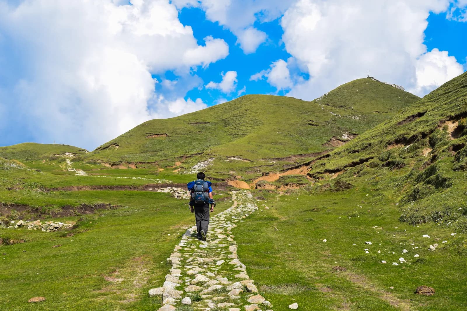
Khaptad National Park Trek
A ten-day trek from Silgadhi in Doti up to the Khaptad plateau at about 3,000 m, with the ashram of Khaptad Baba, the sacred lake of Khaptad Daha and flights to and from Dhangadhi.
- 天數10
- 最高海拔3,276 公尺
- 距離72.5 公里
- 爬升3,301 公尺
- 難度中等
- 最佳月份Mar–May, Oct–Dec
- 許可3
照片:Anil Bhatta · CC BY-SA 4.0
以英文顯示——尚未翻譯。
此行程為草稿,尚未經過確認。請務必與你的嚮導確認各段行程。
Written by FindTrekkingPartner team審閱者:FindTrekkingPartner team我們如何審閱FindTrekkingPartner
Khaptad National Park Trek是位於尼泊爾Khaptad地區的 10 天健行路線,最高海拔達 3,276 公尺。外國健行者可以在 FindTrekkingPartner 發布行程,填入日期、預算與步調,為這條路線尋找夥伴。在雙方健行者都同意之前,配對結果會保持私密,且服務完全免費。 以中等價位計算,四位健行者共用時,持照嚮導 10 天的費用約為每人 93 美元(USD),一人獨自健行則為 373 美元(USD)。最佳季節為Mar–May, Oct–Dec。 這裡實務上需要持照嚮導:據 2026 年業者回報,尼泊爾旅遊局 2023 年 4 月的規定在國家公園與保護區的檢查哨會被執行,其中朗塘(Langtang)最嚴格,安納布爾納(Annapurna)也會查驗(2026 年 10 月 19 日查證)。請透過登記代理商聘請嚮導,並向他們確認。 這條路線的開放行程列於下方,附有出發月份、團隊人數與剩餘名額。 最後查證日期:2026年10月19日。資料來源:尼泊爾旅遊局(Nepal Tourism Board)、DNPWC、移民局。
資料來源:Department of Immigration, NepalNepal Tourism BoardDepartment of National Parks and Wildlife Conservation
尋找Khaptad National Park Trek的夥伴
- 尋找Khaptad National Park Trek的夥伴目前尚無開放行程
概覽
從 Kathmandu 出發10 天 · 最高 3,276 公尺
最佳季節:Mar–May, Oct–Dec · 許可:Khaptad National Park entry permit (NPR 3,000 for foreigners), TIMS card where your agency requires it, No restricted-area permit
The Khaptad National Park trek is a ten-day journey from Kathmandu to the high meadow plateau of Khaptad in far-western Nepal. It flies to Dhangadhi, drives about nine hours to Silgadhi, then walks up the valley road to Jhigrana, climbs a marked path to Bichpani Camp, and crosses the plateau at about 3,000 m to Khaptad, where a rest day visits the lake of Khaptad Daha and the ashram of Khaptad Baba. The return retraces the route and finishes with a drive to Dhangadhi and a flight to Kathmandu. The walking is about 72 km with 3,330 m of climbing, spread over six days. The park entry fee for foreigners is NPR 3,000. Khaptad is not a restricted area, the best months are March to May and October to December, and it is a quiet trek that few foreigners walk.
The plan follows a nine-day operator itinerary and an eleven-day one, which agree on Silgadhi, Bichpani and Khaptad, and the Great Himalaya Trail description, which says that the most popular option is to return the same way. The first walking day is long and mostly on a motor road, and the plateau is level and quiet. Lodging is sparse: expect tents at Bichpani and on the plateau, and homestays or lodges in the villages. The best months are March to May and October to December.
What the trek is like
The trek changes character on the way: a valley road with villages and terraces, a steep forest path to Bichpani, then open grass, scattered trees and a few huts on the plateau. Weather can be wet and cold even in spring, and the plateau offers no shelter in a storm.
Permits and rules
The park entry fee is NPR 3,000 for foreigners and NPR 1,500 for SAARC nationals, per the Nepal Tourism Board. Khaptad is not a restricted area. The Bajhang restricted-area entry applies only to Saipal Rural Municipality.
Best season
March to May and October to December. The Great Himalaya Trail page says winter snow closes the park from late December to the end of February.
Getting there and away
Kathmandu to Dhangadhi is about an hour by air, and the road to Silgadhi takes eight to nine hours. The return mirrors it.
Difficulty and fitness
The trek is moderate in altitude and demanding in logistics. The plateau is at about 3,000 m, so altitude is mild, but the first walking day is about 17.7 km and 1,250 m, the climb to Bichpani Camp is steep, and the journey includes two long travel days. You need to be comfortable camping for several nights and walking six to eight hours in the first days.
Budget notes
The costs section uses Nepal-wide lodge and meal ranges for the town nights, adds the park fee of NPR 3,000 and a guide and porters, shows the flight and the road transfer as lines to check, and states that tents, crew and food for the plateau are quoted by the agency.
What to pack
A warm sleeping bag, a down jacket, waterproofs, poles, a head torch, water treatment, a first-aid kit and a printed copy of your permits. Weather on the open plateau can change quickly.
亮點
- A high meadow plateau at about 3,000 m with oak, pine and rhododendron forest
- The ashram of Khaptad Baba and the Tribeni shrine
- Khaptad Daha, a pilgrimage lake
- Sahashra Linga, about 3,276 m, the park's highest point
- A remote far-west trek that few foreigners visit
路線地圖
路線資料來自 OpenStreetMap,尚未經我們團隊查核。請用於規劃,而非導航。
逐日行程
你今晚的過夜海拔比前一晚高 1,221 公尺,超過一般 500 公尺的準則。請放慢速度、多喝水,並留意是否頭痛或噁心。
A long drive of about eight to nine hours from Dhangadhi to Silgadhi, the headquarters of Doti District, at about 1,330 m, along a road that climbs from the plains into the western hills. The road is rough in places and can be blocked by landslides in the monsoon. Operators give eight to nine hours, and the Great Himalaya Trail page says about six hours from Nepalgunj. Stay in a lodge at Silgadhi, check your gear and plan the next day with your guide. The walk starts early.
你今晚的過夜海拔比前一晚高 920 公尺,超過一般 500 公尺的準則。請放慢速度、多喝水,並留意是否頭痛或噁心。
The first walking day is long. From Silgadhi, walk about 17.7 km and 1,250 m up the valley road to Jhigrana, at about 2,250 m, where the park entrance is. On our map the road is the only route, and the walk takes seven to eight hours by our estimate. Some groups hire a vehicle for part of it. The valley has terraces, small villages and a view of the hills opening up as you climb. Stay in a lodge or homestay at Jhigrana, and register at the park entrance.
A shorter day of about 6.2 km, with 920 m of climbing, four to five hours, takes you from Jhigrana to Bichpani Camp, on a marked path through forest, past rhododendron and oak. Bichpani Camp is at about 3,100 m by the elevation model, a meadow with a few huts and tents, and the first place where you sleep above 3,000 m. Operators give about 2,743 m, which is far from the model, so we do not state a height. Rest in the afternoon, drink plenty of water and wrap up warm, since the nights are cold.
From Bichpani Camp, walk about 9.5 km across open plateau to Khaptad, in three to four hours, which is nearly level at about 3,000 m on grass and forest tracks. The Saipal range appears on the horizon in clear weather. Khaptad, where a hotel and the park buildings stand, is the base for the next day. Your tent or lodge is here for two nights. Rest, wander the meadows and watch for birds. You are well above 3,000 m, so a short walk in the evening helps with sleep.
A day to explore. A walk of about 5.7 km round trip, three to four hours, takes you to Khaptad Daha, the lake beside the trail to Kolti where local people believe Shiva bathed. The ashram of Khaptad Baba, who meditated here for about fifty years and died in 1996, is near the park headquarters, and Tribeni, a confluence of streams with a Shiva temple, is also on the plateau. Strong walkers can add Sahashra Linga, about 3,276 m and a five-hour round trip, if the weather is good. Dress modestly at the shrines.
A long downhill day of about 15.7 km and 1,210 m of descent, six to seven hours by our estimate, takes you from Khaptad back over Bichpani Camp to Jhigrana. The way is the same as the way up: grass and forest tracks across the plateau, then the steep marked path through forest. Because it is downhill, the day is faster than the climb, but it is hard on the knees, so use poles. You sleep at Jhigrana again, where the lodge is familiar.
Walk about 17.7 km down the valley road from Jhigrana to Silgadhi, with 1,240 m of descent, six to seven hours by our estimate. You can ask a vehicle to meet you part of the way, as the road reaches the Jhigrana area. At Silgadhi you reach roads, shops and a hot meal. The last night in the hills is a good time to thank your crew, and to repack for the long drive tomorrow. Silgadhi sits at about 1,330 m.
Drive from Silgadhi to Dhangadhi, eight to nine hours. The road drops from the hills to the plains and is slow in places, so leave early and carry snacks, water and a warm layer for the first cool hours. Spend the night in a hotel at Dhangadhi near the airport, ready for the morning flight, and settle accounts with your crew and guide this evening. If rain has closed the road, tell your agency early so it can rebook the flight for the next available day.
Fly from Dhangadhi to Kathmandu, about an hour, and arrive in the city by midday if the weather is clear. Flights in the far west are the most likely to be cancelled, so keep a spare day in your plan before an international flight, and ask your agency about the next available seat if the morning flight does not operate. Transfer to your hotel, wash, and rest, then spend the afternoon in the city. Ten days of camping and simple food leave most people glad of a proper bed.
高度適應
逐夜的過夜海拔。紅色長條表示比前一晚爬升超過 500 公尺;休息日會另外標示。
- 過夜海拔
- 爬升超過 500 公尺
- 休息日
費用
每人的全包估計費用:依海拔計算的旅舍與餐食、交通、許可,以及嚮導與挑夫。分攤嚮導與挑夫的健行者越多,每個人付的就越少。 截至 2026年10月。
| 風格 | 1 位健行者分攤 | 2 位健行者分攤 | 4 位健行者分攤 |
|---|---|---|---|
| 經濟 | US$190–US$300* | US$190–US$300* | US$190–US$300* |
| 中等 | US$590–US$910* | US$420–US$650* | US$360–US$560* |
| 舒適 | US$670–US$1,050* | US$550–US$840* | US$490–US$750* |
分攤嚮導,省下開銷
以中等價位計算,單獨健行者約需支付 US$590–US$910;四位健行者分攤一位嚮導和兩位挑夫,每人約 US$360–US$560(以價格區間上限計算,少 38%)。
2 位健行者分攤的費用明細
| 項目 | 經濟 | 中等 | 舒適 |
|---|---|---|---|
| 旅舍與餐食 | US$150–US$260 | US$220–US$360 | US$300–US$470 |
| 許可 | US$30–US$40 | US$30–US$40 | US$30–US$40 |
| 嚮導 | — | US$110–US$180 | US$110–US$180 |
| 挑夫 | — | US$40–US$80 | US$90–US$160 |
經濟型使用大眾運輸且不請挑夫;中等價位為兩位健行者共用一位挑夫和一輛包車;舒適型則每位健行者各有一位挑夫。在規定需要嚮導,或風格為中等價位或舒適型時,費用已包含嚮導。
每晚旅舍與餐食(房間與一份 dal bhat 餐)
6 晚Below 2,500 m:房間 US$2–US$9,dal bhat US$4–US$7 · 3 晚2,500 to 3,800 m:房間 US$4–US$11,dal bhat US$5–US$11
許可費用(官方來源)
不含
找不到以下項目的公開價格:Kathmandu to Dhangadhi flight (return); Dhangadhi to Silgadhi by road (return)。標有 * 的總額未計入這些項目;請向旅行社詢問。 這是露營式健行:工作人員、帳篷與餐食由旅行社報價。 Tents, crew, kitchen and food on the plateau are quoted by the agency and are not in this estimate; the town nights use lodge rates.
費用來源
- PriceNepal: Nepal Travel Cost Guide 2026 (2026-05-14)
- Third Rock Adventures: Nepal trek budget planner (2026-05-09)
- Himalayan Partner: Guide and porter price in Nepal 2026 (2026-02-10)
- Shikhar Adventure: Annapurna Circuit trek cost (2026-02-03)
- Nepal Tourism Board: Trekking Permit (2026-10-18)
估算依據業者指南,並非報價。小費、保險、裝備與加德滿都的飯店不包含;美元依平台匯率計算。
照片
常見問題
This plan takes ten days from Kathmandu to Kathmandu: two days of flights and roads each way, six days of walking including a rest day on the plateau. Operators sell versions of seven to twelve days, and the Great Himalaya Trail notes that most people return the way they came.
NPR 3,000 per person per entry for foreigners and NPR 1,500 for SAARC nationals, according to the Nepal Tourism Board's park fee table. One operator page quotes NPR 1,500 for foreigners, which is the SAARC figure.
The plateau is at about 3,000 m on our elevation model. The park ranges from about 1,400 m to 3,300 m, and Sahashra Linga, at about 3,276 m, is its highest point, according to the Great Himalaya Trail page and an operator.
An ascetic who spent about fifty years meditating in the area and died in 1996, according to the Great Himalaya Trail page. The park was established in 1984 on his advice, per Wikipedia.
March to May and October to December. Winter snow closes the park from late December to the end of February, and monsoon rain can close roads for weeks.
資料來源
沿途地點
路線每一天沿途的住宿、醫療協助、水源與景點。
1. Kathmandu → Dhangadhi
- Tribhuvan International Airport · 機場與交通 · 1,340 公尺
2. Dhangadhi → Silgadhi
這一天尚未標繪任何地點。這一天尚未標繪任何地點。3. Silgadhi → Jhigrana
- Saileshoi guest houe · 住宿 · 1,275 公尺
- Baglekh Health Post · 醫療 · 1,701 公尺
4. Jhigrana → Bichpani Camp
這一天尚未標繪任何地點。這一天尚未標繪任何地點。5. Bichpani Camp → Khaptad
- Khaptad Hotel · 住宿 · 3,052 公尺
6. Khaptad
這一天尚未標繪任何地點。這一天尚未標繪任何地點。7. Khaptad → Jhigrana
- Bichpani saud hotel · 住宿 · 3,109 公尺
8. Jhigrana → Silgadhi
- Jhigrana Hotel · 住宿 · 2,241 公尺
- Baglekh · 住宿 · 2,044 公尺
- Doti District Hospital · 醫療 · 1,379 公尺
- Hotel Lord Buddha · 住宿 · 1,309 公尺
9. Silgadhi → Dhangadhi
這一天尚未標繪任何地點。這一天尚未標繪任何地點。10. Dhangadhi → Kathmandu
這一天尚未標繪任何地點。這一天尚未標繪任何地點。
最後確認於 2026年10月19日回報過時資訊