

Start in the old town at Sitalpati, the white octagonal pavilion in the main square, and wander the steep Newari lanes past shops selling dhaka cloth and brass pots to the Palpa Durbar and its Mul Dhoka gateway. Then climb to Srinagar Hill, which Nepal Traveller gives as 30 to 60 minutes from the town centre. On our map the town and hill loop is 4.4 km with about 160 m of climbing. From the view tower, Wikipedia lists the peaks from Kanjiroba and Dhaulagiri to Annapurna, Manaslu, Ganesh and Langtang, so go at dawn or dusk. Return to town by the same lanes.
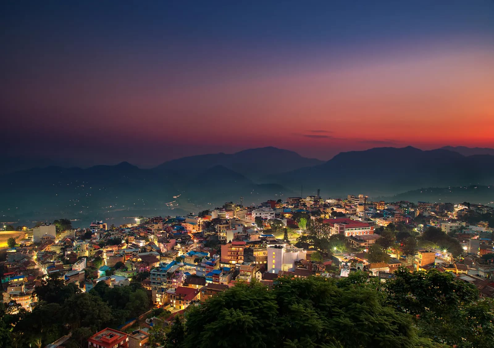
Tansen, Srinagar Hill and Ranighat
A two-day walk from the Magar hill town of Tansen: the lanes and the Srinagar Hill view tower on day one, and a 13 km descent to the Rani Mahal palace at Ranighat on day two, with no permit.
- Ngày2
- Độ cao tối đa1.490 m
- Quãng đường17,4 km
- Độ cao leo298 m
- Độ khóDễ
- Tháng đẹp nhấtOct–Nov, Mar–Apr
Lên kế hoạch chuyến đi theo lịch trình nàyTìm bạn đồng hành cho Tansen, Srinagar Hill and RanighatXem lịch khởi hành theo tuần
Ảnh: Mithunkunwar9 · CC BY-SA 4.0
Hiển thị bằng tiếng Anh — chưa được dịch.
Lịch trình này là bản nháp và chưa được xác minh. Luôn xác nhận các chặng với hướng dẫn viên của bạn.
Written by FindTrekkingPartner teamĐược FindTrekkingPartner team kiểm duyệtCách chúng tôi kiểm duyệtFindTrekkingPartner
Tansen, Srinagar Hill and Ranighat là chuyến trek 2 ngày ở vùng Palpa (Tansen) của Nepal, leo lên độ cao 1.490 m. Trekker nước ngoài có thể tìm bạn đồng hành cho chuyến này trên FindTrekkingPartner bằng cách đăng chuyến đi kèm ngày đi, ngân sách và tốc độ. Các kết nối được giữ riêng tư cho đến khi cả hai trekker đồng ý, và dịch vụ này miễn phí. Ở mức giá tầm trung, một hướng dẫn viên có giấy phép tốn khoảng 19 USD mỗi người trong 2 ngày khi bốn trekker chia sẻ, so với 75 USD cho một trekker đi một mình. Các mùa đẹp nhất là Oct–Nov, Mar–Apr. Hướng dẫn viên có giấy phép không bị bắt buộc trên các cung đường mở như thế này (kiểm tra ngày 19 tháng 10 năm 2026): chính quyền Khumbu đã không áp dụng quy định tháng 4 năm 2023 của Cục Du lịch Nepal (Nepal Tourism Board) và các chuyến đi bộ trong ngày không cần hướng dẫn viên, nhưng vẫn rất nên có hướng dẫn viên, vì vậy hãy xác nhận với công ty lữ hành của bạn. Xác minh lần cuối: 19 tháng 10, 2026. Nguồn: Cục Du lịch Nepal (Nepal Tourism Board), DNPWC, Cục Xuất nhập cảnh.
Nguồn:Department of Immigration, NepalNepal Tourism BoardDepartment of National Parks and Wildlife Conservation
Tìm bạn đồng hành cho Tansen, Srinagar Hill and Ranighat
- Tìm bạn đồng hành cho Tansen, Srinagar Hill and RanighatChưa có chuyến đi đang mở
Tổng quan
Khởi hành từ Tansen2 ngày · tối đa 1.490 m
Mùa đẹp nhất: Oct–Nov, Mar–Apr
Tansen, Srinagar Hill and Ranighat is a two-day walking plan from the Magar hill town of Tansen in Palpa: a town and hill day to Sitalpati and the Srinagar view tower, and a long descent to Rani Mahal, the Rana palace at Ranighat on the Kali Gandaki. On our map the first day is 4.4 km with about 160 m of climbing and the second is 13.0 km with about 1,000 m of descent, mostly on the Rani Mahal road. Sources give 30 to 60 minutes from town to Srinagar Hill and 2 to 3 hours down to Ranighat, with a return climb of about 4 hours or a car, so the second day is a big one-way day. No permit or flight is needed, and October to November and March to April are best.
What the walk is like
Day one is gentle: the old lanes of Tansen, the white octagonal Sitalpati pavilion, the Palpa Durbar and the climb to Srinagar Hill for a view from Dhaulagiri to Langtang. Day two goes down the valley of the Barandi Khola, through terraces, forest and small farms, to Ranighat, where the restored Rani Mahal stands on a bluff above the river. Most walkers go down on foot and come back by car, since the climb back is steep and takes about 4 hours.
Day by day
Day one is 4.4 km, 2 to 3 hours including time in the town. Day two is 13.0 km down, 3 to 4 hours, and a car or the 4 hour climb back to Tansen. If you prefer a shorter day, drive to Batase Danda on the ridge and walk from there, as a 2008 trip report did, which gives about 3 hours down to Ranighat.
Getting there and away
Tansen lies between Pokhara (122 km) and Lumbini (85 km) on the highway between Butwal and Pokhara, with direct buses from Kathmandu, Pokhara and Bhairahawa; Bhairahawa is about two hours away.
Permits, guides and costs
No trekking permit or TIMS card is needed, and Palpa lies outside any national park, conservation area or restricted area, so no guide is required; one is optional. Costs are the two nights, the transfers and the car back from Ranighat; see the cost section for ranges.
Season and safety
Clear air in October to November makes the best views, and March to April is warm. The pebble trail and stone steps are slippery in fog and rain, and the valley is hot in spring. See our guide rule page for the rule in full.
Điểm nổi bật
- Old Tansen lanes with the octagonal Sitalpati pavilion and the Palpa Durbar
- Srinagar Hill view tower, 30 to 60 minutes from town, over Dhaulagiri, Annapurna and Langtang
- A long descent to Rani Mahal, the restored Rana palace on the Kali Gandaki
- Dhaka cloth and brass pots from the shops of the old town
- No permit and no flight
Bản đồ lộ trình
Dữ liệu lộ trình từ OpenStreetMap, nhóm chúng tôi chưa kiểm tra. Hãy dùng để lên kế hoạch, không dùng để dẫn đường.
Từng ngày
Leave early and head down towards the Kali Gandaki. Sources give 2 to 3 hours for the descent, and our map shows 13.0 km with about 1,000 m of descent, mostly by the Rani Mahal road through terraced fields and forest, so we allow 3 to 4 hours. Rani Mahal, built in 1893 by General Khadga Shamsher for his wife, stands on a wooded bluff above the river and has been a museum since its restoration in 2017. The climb back to Tansen takes about 4 hours and is steep, so most visitors arrange a car for the return, then rest in town.
Chi phí
Chi phí trọn gói ước tính cho mỗi người: nhà trọ và ăn uống theo độ cao, di chuyển, giấy phép, hướng dẫn viên và porter. Càng nhiều người trekking chia chung hướng dẫn viên và porter, mỗi người trả càng ít. Tính đến tháng 10 năm 2026.
| Phong cách | 1 người trekking chia chung | 2 người trekking chia chung | 4 người trekking chia chung |
|---|---|---|---|
| Tiết kiệm | 30 US$–60 US$* | 30 US$–60 US$* | 30 US$–60 US$* |
| Tầm trung | 130 US$–220 US$* | 80 US$–150 US$* | 70 US$–120 US$* |
| Thoải mái | 150 US$–240 US$* | 120 US$–190 US$* | 100 US$–170 US$* |
Chia chung hướng dẫn viên, tiết kiệm tiền
Ở mức tầm trung, một người trekking một mình trả khoảng 130 US$–220 US$; bốn người chia chung một hướng dẫn viên và hai porter trả khoảng 70 US$–120 US$ mỗi người (rẻ hơn 44% ở đầu trên của khoảng giá).
Chi tiết cho 2 người trekking chia chung
| Khoản mục | Tiết kiệm | Tầm trung | Thoải mái |
|---|---|---|---|
| Nhà trọ và ăn uống | 30 US$–60 US$ | 40 US$–80 US$ | 50 US$–100 US$ |
| Hướng dẫn viên | — | 20 US$–50 US$ | 20 US$–50 US$ |
| Porter | — | 10 US$–30 US$ | 30 US$–60 US$ |
Tiết kiệm dùng phương tiện công cộng và không có porter; tầm trung chia một porter cho hai người trekking và dùng xe riêng; thoải mái cho mỗi người một porter. Hướng dẫn viên được tính khi bắt buộc hoặc khi phong cách là tầm trung hay thoải mái.
Nhà trọ và ăn uống mỗi đêm (phòng và một bữa dal bhat)
2 đêm Below 2,500 m: phòng 2 US$–9 US$, dal bhat 4 US$–7 US$
Chưa bao gồm
Không tìm thấy giá công bố cho: Pokhara to Tansen by bus or car; Ranighat back to Tansen by car. Các tổng có dấu * chưa tính những khoản này; hãy hỏi công ty du lịch của bạn. A homestay-based walk with no permit: the costs are the nights, meals and the car back from Ranighat. A guide is optional.
Nguồn chi phí
- PriceNepal: Nepal Travel Cost Guide 2026 (2026-05-14)
- Third Rock Adventures: Nepal trek budget planner (2026-05-09)
- Himalayan Partner: Guide and porter price in Nepal 2026 (2026-02-10)
- Shikhar Adventure: Annapurna Circuit trek cost (2026-02-03)
- Nepal Tourism Board: Trekking Permit (2026-10-18)
Ước tính từ hướng dẫn của nhà điều hành, không phải báo giá. Tiền boa, bảo hiểm, đồ dùng và khách sạn ở Kathmandu không được tính; USD theo tỷ giá của nền tảng.
Ảnh
Câu hỏi thường gặp
Sources give 2 to 3 hours down, and our map shows 13.0 km, so we allow 3 to 4 hours. The climb back is about 4 hours, or arrange a car.
Possible but long. Srinagar Hill is 30 to 60 minutes from town and the Ranighat descent 3 to 4 hours, so most walkers split the two days.
Yes. The palace was restored in 2017 and has a museum inside. Ask in Tansen about any ticket and the opening time on the day.
October to November for clear views and March to April for warm days; the monsoon brings cloud and mud.
No. Palpa is not a restricted area, and the walks avoid national parks and conservation areas. A guide is optional.
Nguồn
Dọc đường mòn
Chỗ ở, hỗ trợ y tế, nước và cảnh đẹp trong mỗi ngày của lộ trình.
1. Tansen
- Sangam medical hall · Y tế · 1.281 m
- Ayush pharmacy · Y tế · 1.273 m
- The Bajra · Chỗ ở · 1.277 m
- Laxmi Homestay · Chỗ ở · 1.331 m
- Horizon Homestay · Chỗ ở · 1.350 m
- Annapurna garden · Chỗ ở · 1.329 m
- View Tower · Điểm ngắm cảnh · 1.492 m
- Shreenagar View Tower · Điểm ngắm cảnh · 1.439 m
Show all 13 places
- The Bajra · Chỗ ở · 1.277 m
- Lumbini Medical College · Sân bay & giao thông · 873 m
- Hotel Tansen · Chỗ ở · 1.262 m
- Sangam medical hall · Y tế · 1.281 m
- Ayush pharmacy · Y tế · 1.273 m
- Rock Regency Guest House · Chỗ ở · 1.269 m
- Hotel Crown · Chỗ ở · 1.305 m
- Laxmi Homestay · Chỗ ở · 1.331 m
- Horizon Homestay · Chỗ ở · 1.350 m
- Annapurna garden · Chỗ ở · 1.329 m
- United Mission Tansen Hospital · Y tế · 1.320 m
- View Tower · Điểm ngắm cảnh · 1.492 m
- Shreenagar View Tower · Điểm ngắm cảnh · 1.439 m
2. Tansen → Ranighat
- LMC Town Clinic · Y tế · 1.277 m
- Indreni Restaurant and Lodge · Chỗ ở · 1.275 m
- Ashoka Guest House $ · Chỗ ở · 1.276 m
- Palpa District Hospital · Y tế · 1.300 m
- The White Lake · Chỗ ở · 1.312 m
- Batasedaada · Điểm ngắm cảnh · 1.393 m
- Rice fields Valley · Điểm ngắm cảnh · 1.010 m
- Dew Camping Resort · Chỗ ở · 692 m
Show all 16 places
- Indreni Restaurant and Lodge · Chỗ ở · 1.275 m
- Ashoka Guest House $ · Chỗ ở · 1.276 m
- Upakar Medical Hall · Y tế · 1.278 m
- LMC Town Clinic · Y tế · 1.277 m
- The White Lake · Chỗ ở · 1.312 m
- Palpa District Hospital · Y tế · 1.300 m
- Hotel Gauri Shankar · Chỗ ở · 1.294 m
- Bhattarai medical hall · Y tế · 1.322 m
- City View Homestay · Chỗ ở · 1.330 m
- Amatya Homestay · Chỗ ở · 1.331 m
- Sunrise View Homestay · Chỗ ở · 1.332 m
- Hotel Srinagar · Chỗ ở · 1.420 m
- Batasedaada · Điểm ngắm cảnh · 1.393 m
- Rice fields Valley · Điểm ngắm cảnh · 1.010 m
- Ranimahal Fishing Resort · Chỗ ở · 877 m
- Dew Camping Resort · Chỗ ở · 692 m
Xác minh lần cuối ngày 19 thg 10, 2026Báo cáo thông tin lỗi thời