

Fly from Kathmandu to Dhangadhi, a flight of about an hour according to the operator itineraries we read, to the warm Terai plains at about 110 m. Transfer to a hotel, meet your guide and crew, and check permits, gear, tents, stoves and food, since the plateau has no shops. The next day is a long drive, so buy snacks and water, and have an early night. Flights can be delayed or cancelled, so do not schedule a connecting international flight on the same day, and keep your passport handy for the airport and the park permits.
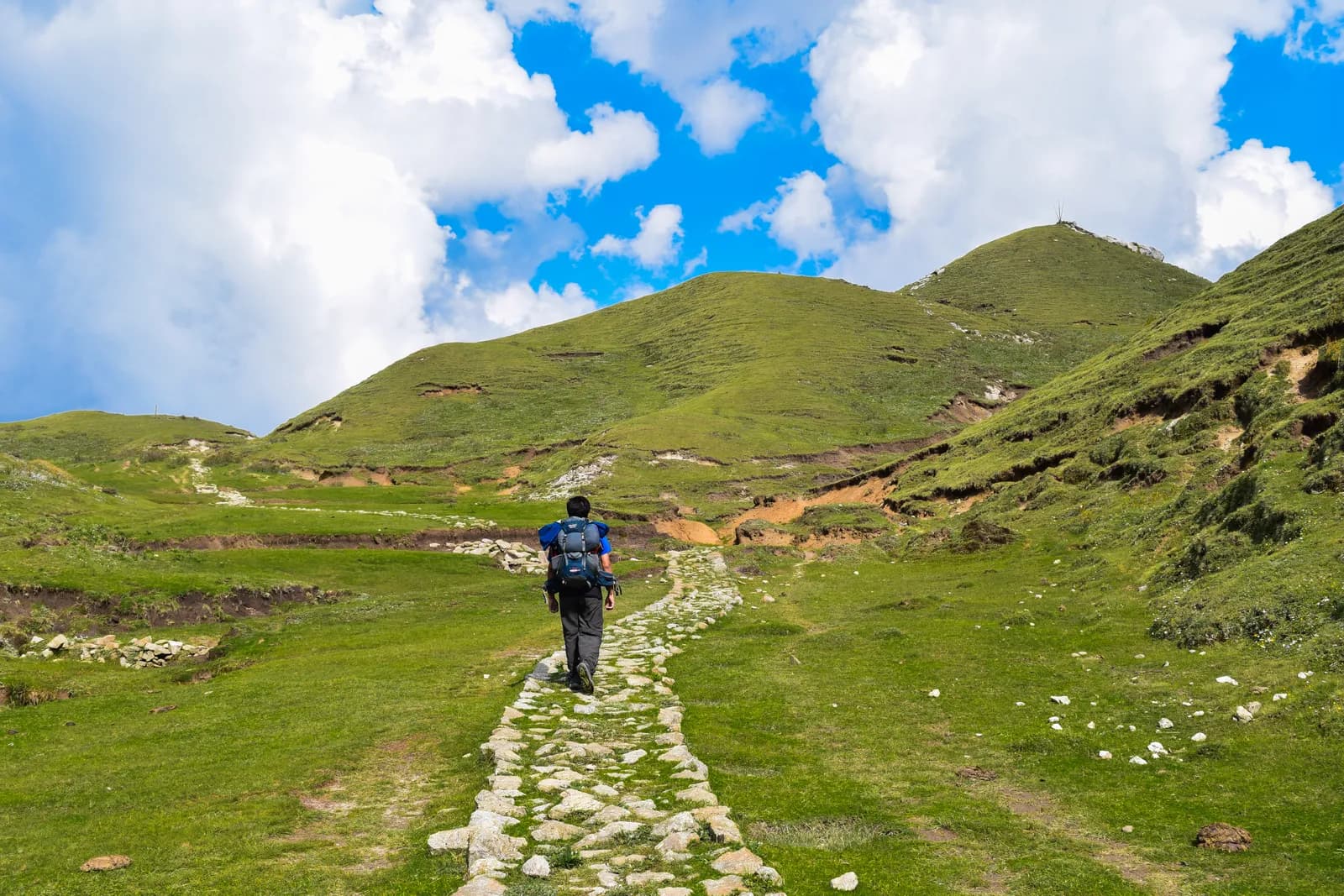
Khaptad National Park Trek
A ten-day trek from Silgadhi in Doti up to the Khaptad plateau at about 3,000 m, with the ashram of Khaptad Baba, the sacred lake of Khaptad Daha and flights to and from Dhangadhi.
- Gün10
- En yüksek rakım3.276 m
- Mesafe72,5 km
- Yükseliş3.301 m
- ZorlukOrta
- En iyi aylarMar–May, Oct–Dec
- İzinler3
Fotoğraf: Anil Bhatta · CC BY-SA 4.0
İngilizce gösteriliyor — henüz çevrilmedi.
Bu rota bir taslaktır ve henüz doğrulanmadı. Etapları her zaman rehberinle teyit et.
Written by FindTrekkingPartner teamİnceleyen: FindTrekkingPartner teamNasıl inceliyoruzFindTrekkingPartner
Khaptad National Park Trek, Nepal’in Khaptad bölgesinde 3.276 m’ye çıkan 10 günlük bir trekkingdir. Yabancı trekkingciler FindTrekkingPartner’da tarihlerini, bütçelerini ve tempolarını belirterek bir gezi paylaşıp bu rota için partner bulabilir. Eşleşmeler iki trekkingci de kabul edene kadar gizli kalır ve hizmet ücretsizdir. Orta seviye fiyatlarla lisanslı bir rehber, dört trekkingci paylaştığında 10 günde kişi başı yaklaşık 93 USD tutar; tek başına giden bir trekkingci için bu tutar 373 USD’dir. En iyi sezonlar: Mar–May, Oct–Dec. Burada pratikte lisanslı rehber gereklidir: 2026 operatörlerine göre Nepal Turizm Kurulu’nun Nisan 2023 kuralı milli parklardaki ve koruma alanlarındaki kontrol noktalarında uygulanıyor; en sıkı denetim Langtang’da, Annapurna’da da kontrol yapılıyor (19 Ekim 2026’da kontrol edildi). Kayıtlı bir acente aracılığıyla rehber tut ve onlarla teyit et. Bu rota için açık geziler aşağıda; başlangıç ayı, grup büyüklüğü ve kalan yerlerle birlikte listelenir. Son doğrulama: 19 Ekim 2026. Kaynaklar: Nepal Turizm Kurulu, DNPWC, Göç İdaresi.
Kaynaklar:Department of Immigration, NepalNepal Tourism BoardDepartment of National Parks and Wildlife Conservation
Khaptad National Park Trek için partner bul
- Khaptad National Park Trek için partner bulHenüz açık gezi yok
Genel bakış
Başlangıç: Kathmandu10 gün · maks. 3.276 m
En iyi mevsimler: Mar–May, Oct–Dec · İzinler: Khaptad National Park entry permit (NPR 3,000 for foreigners), TIMS card where your agency requires it, No restricted-area permit
The Khaptad National Park trek is a ten-day journey from Kathmandu to the high meadow plateau of Khaptad in far-western Nepal. It flies to Dhangadhi, drives about nine hours to Silgadhi, then walks up the valley road to Jhigrana, climbs a marked path to Bichpani Camp, and crosses the plateau at about 3,000 m to Khaptad, where a rest day visits the lake of Khaptad Daha and the ashram of Khaptad Baba. The return retraces the route and finishes with a drive to Dhangadhi and a flight to Kathmandu. The walking is about 72 km with 3,330 m of climbing, spread over six days. The park entry fee for foreigners is NPR 3,000. Khaptad is not a restricted area, the best months are March to May and October to December, and it is a quiet trek that few foreigners walk.
The plan follows a nine-day operator itinerary and an eleven-day one, which agree on Silgadhi, Bichpani and Khaptad, and the Great Himalaya Trail description, which says that the most popular option is to return the same way. The first walking day is long and mostly on a motor road, and the plateau is level and quiet. Lodging is sparse: expect tents at Bichpani and on the plateau, and homestays or lodges in the villages. The best months are March to May and October to December.
What the trek is like
The trek changes character on the way: a valley road with villages and terraces, a steep forest path to Bichpani, then open grass, scattered trees and a few huts on the plateau. Weather can be wet and cold even in spring, and the plateau offers no shelter in a storm.
Permits and rules
The park entry fee is NPR 3,000 for foreigners and NPR 1,500 for SAARC nationals, per the Nepal Tourism Board. Khaptad is not a restricted area. The Bajhang restricted-area entry applies only to Saipal Rural Municipality.
Best season
March to May and October to December. The Great Himalaya Trail page says winter snow closes the park from late December to the end of February.
Getting there and away
Kathmandu to Dhangadhi is about an hour by air, and the road to Silgadhi takes eight to nine hours. The return mirrors it.
Difficulty and fitness
The trek is moderate in altitude and demanding in logistics. The plateau is at about 3,000 m, so altitude is mild, but the first walking day is about 17.7 km and 1,250 m, the climb to Bichpani Camp is steep, and the journey includes two long travel days. You need to be comfortable camping for several nights and walking six to eight hours in the first days.
Budget notes
The costs section uses Nepal-wide lodge and meal ranges for the town nights, adds the park fee of NPR 3,000 and a guide and porters, shows the flight and the road transfer as lines to check, and states that tents, crew and food for the plateau are quoted by the agency.
What to pack
A warm sleeping bag, a down jacket, waterproofs, poles, a head torch, water treatment, a first-aid kit and a printed copy of your permits. Weather on the open plateau can change quickly.
Öne çıkanlar
- A high meadow plateau at about 3,000 m with oak, pine and rhododendron forest
- The ashram of Khaptad Baba and the Tribeni shrine
- Khaptad Daha, a pilgrimage lake
- Sahashra Linga, about 3,276 m, the park's highest point
- A remote far-west trek that few foreigners visit
Rota haritası
Rota verileri OpenStreetMap'ten alındı, ekibimiz henüz kontrol etmedi. Planlama için kullan, navigasyon için değil.
Gün gün
Bir önceki geceye göre 1.221 m daha yüksekte uyuyorsun; bu, olağan 500 m kılavuz sınırının üzerinde. Yavaş ilerle, bol su iç ve baş ağrısı veya mide bulantısına dikkat et.
A long drive of about eight to nine hours from Dhangadhi to Silgadhi, the headquarters of Doti District, at about 1,330 m, along a road that climbs from the plains into the western hills. The road is rough in places and can be blocked by landslides in the monsoon. Operators give eight to nine hours, and the Great Himalaya Trail page says about six hours from Nepalgunj. Stay in a lodge at Silgadhi, check your gear and plan the next day with your guide. The walk starts early.
Bir önceki geceye göre 920 m daha yüksekte uyuyorsun; bu, olağan 500 m kılavuz sınırının üzerinde. Yavaş ilerle, bol su iç ve baş ağrısı veya mide bulantısına dikkat et.
The first walking day is long. From Silgadhi, walk about 17.7 km and 1,250 m up the valley road to Jhigrana, at about 2,250 m, where the park entrance is. On our map the road is the only route, and the walk takes seven to eight hours by our estimate. Some groups hire a vehicle for part of it. The valley has terraces, small villages and a view of the hills opening up as you climb. Stay in a lodge or homestay at Jhigrana, and register at the park entrance.
A shorter day of about 6.2 km, with 920 m of climbing, four to five hours, takes you from Jhigrana to Bichpani Camp, on a marked path through forest, past rhododendron and oak. Bichpani Camp is at about 3,100 m by the elevation model, a meadow with a few huts and tents, and the first place where you sleep above 3,000 m. Operators give about 2,743 m, which is far from the model, so we do not state a height. Rest in the afternoon, drink plenty of water and wrap up warm, since the nights are cold.
From Bichpani Camp, walk about 9.5 km across open plateau to Khaptad, in three to four hours, which is nearly level at about 3,000 m on grass and forest tracks. The Saipal range appears on the horizon in clear weather. Khaptad, where a hotel and the park buildings stand, is the base for the next day. Your tent or lodge is here for two nights. Rest, wander the meadows and watch for birds. You are well above 3,000 m, so a short walk in the evening helps with sleep.
A day to explore. A walk of about 5.7 km round trip, three to four hours, takes you to Khaptad Daha, the lake beside the trail to Kolti where local people believe Shiva bathed. The ashram of Khaptad Baba, who meditated here for about fifty years and died in 1996, is near the park headquarters, and Tribeni, a confluence of streams with a Shiva temple, is also on the plateau. Strong walkers can add Sahashra Linga, about 3,276 m and a five-hour round trip, if the weather is good. Dress modestly at the shrines.
A long downhill day of about 15.7 km and 1,210 m of descent, six to seven hours by our estimate, takes you from Khaptad back over Bichpani Camp to Jhigrana. The way is the same as the way up: grass and forest tracks across the plateau, then the steep marked path through forest. Because it is downhill, the day is faster than the climb, but it is hard on the knees, so use poles. You sleep at Jhigrana again, where the lodge is familiar.
Walk about 17.7 km down the valley road from Jhigrana to Silgadhi, with 1,240 m of descent, six to seven hours by our estimate. You can ask a vehicle to meet you part of the way, as the road reaches the Jhigrana area. At Silgadhi you reach roads, shops and a hot meal. The last night in the hills is a good time to thank your crew, and to repack for the long drive tomorrow. Silgadhi sits at about 1,330 m.
Drive from Silgadhi to Dhangadhi, eight to nine hours. The road drops from the hills to the plains and is slow in places, so leave early and carry snacks, water and a warm layer for the first cool hours. Spend the night in a hotel at Dhangadhi near the airport, ready for the morning flight, and settle accounts with your crew and guide this evening. If rain has closed the road, tell your agency early so it can rebook the flight for the next available day.
Fly from Dhangadhi to Kathmandu, about an hour, and arrive in the city by midday if the weather is clear. Flights in the far west are the most likely to be cancelled, so keep a spare day in your plan before an international flight, and ask your agency about the next available seat if the morning flight does not operate. Transfer to your hotel, wash, and rest, then spend the afternoon in the city. Ten days of camping and simple food leave most people glad of a proper bed.
İklimlendirme
Gece gece uyku rakımı. Kırmızı çubuklar bir önceki geceye göre 500 m'den fazla yükselir; dinlenme günleri işaretlidir.
- Uyku rakımı
- 500 m üzeri artış
- Dinlenme günü
Maliyeti
Kişi başı tahmini toplam maliyet: rakıma göre konaklama ve yemek, ulaşım, izinler, rehber ve porterler. Bir rehberi ve porterleri paylaşan trekkingci sayısı arttıkça kişi başı ödenen azalır. Ekim 2026 itibarıyla.
| Tarz | 1 trekkingci | 2 trekkingci paylaşıyor | 4 trekkingci paylaşıyor |
|---|---|---|---|
| Ekonomik | $190–$300* | $190–$300* | $190–$300* |
| Orta seviye | $590–$910* | $420–$650* | $360–$560* |
| Konforlu | $670–$1.050* | $550–$840* | $490–$750* |
Rehberi paylaş, tasarruf et
Orta seviyede, tek başına bir trekkingci yaklaşık $590–$910 öder; bir rehberi ve iki porteri paylaşan dört trekkingci kişi başı yaklaşık $360–$560 öder (aralığın üst ucunda %38 daha az).
Paylaşan 2 trekkingci için döküm
| Kalem | Ekonomik | Orta seviye | Konforlu |
|---|---|---|---|
| Konaklama ve yemek | $150–$260 | $220–$360 | $300–$470 |
| İzinler | $30–$40 | $30–$40 | $30–$40 |
| Rehber | — | $110–$180 | $110–$180 |
| Porterler | — | $40–$80 | $90–$160 |
Ekonomik tarz toplu taşıma kullanır ve porter içermez; orta seviye iki trekkingci arasında bir porter ve özel araç paylaşımı içerir; konforlu tarz her trekkingciye bir porter verir. Rehber, zorunlu olduğunda veya tarz orta seviye ya da konforlu olduğunda dahildir.
Gecelik konaklama ve yemek (oda ve bir dal bhat yemeği)
6 gece Below 2,500 m: oda $2–$9, dal bhat $4–$7 · 3 gece 2,500 to 3,800 m: oda $4–$11, dal bhat $5–$11
İzin ücretleri (resmi kaynaklar)
Dahil değil
Şunlar için yayımlanmış fiyat bulunamadı: Kathmandu to Dhangadhi flight (return); Dhangadhi to Silgadhi by road (return). * ile işaretli toplamlar bunları içermez; acentenden sor. Bu bir kamp trekkingi: ekip, çadırlar ve yemek acente tarafından fiyatlandırılır. Tents, crew, kitchen and food on the plateau are quoted by the agency and are not in this estimate; the town nights use lodge rates.
Maliyet kaynakları
- PriceNepal: Nepal Travel Cost Guide 2026 (2026-05-14)
- Third Rock Adventures: Nepal trek budget planner (2026-05-09)
- Himalayan Partner: Guide and porter price in Nepal 2026 (2026-02-10)
- Shikhar Adventure: Annapurna Circuit trek cost (2026-02-03)
- Nepal Tourism Board: Trekking Permit (2026-10-18)
Teklif değil, operatör rehberlerinden tahminlerdir. Bahşişler, sigorta, ekipman ve Kathmandu otelleri dahil değildir; USD platform döviz kuruyladır.
Fotoğraflar
Sık sorulan sorular
This plan takes ten days from Kathmandu to Kathmandu: two days of flights and roads each way, six days of walking including a rest day on the plateau. Operators sell versions of seven to twelve days, and the Great Himalaya Trail notes that most people return the way they came.
NPR 3,000 per person per entry for foreigners and NPR 1,500 for SAARC nationals, according to the Nepal Tourism Board's park fee table. One operator page quotes NPR 1,500 for foreigners, which is the SAARC figure.
The plateau is at about 3,000 m on our elevation model. The park ranges from about 1,400 m to 3,300 m, and Sahashra Linga, at about 3,276 m, is its highest point, according to the Great Himalaya Trail page and an operator.
An ascetic who spent about fifty years meditating in the area and died in 1996, according to the Great Himalaya Trail page. The park was established in 1984 on his advice, per Wikipedia.
March to May and October to December. Winter snow closes the park from late December to the end of February, and monsoon rain can close roads for weeks.
Kaynaklar
Patika boyunca
Rotanın her gününde konaklama, sağlık desteği, su ve görülecek yerler.
1. Kathmandu → Dhangadhi
- Tribhuvan International Airport · Havalimanları ve ulaşım · 1.340 m
2. Dhangadhi → Silgadhi
Bu gün için henüz haritalanmış bir şey yok.Bu gün için henüz haritalanmış bir şey yok.3. Silgadhi → Jhigrana
- Saileshoi guest houe · Konaklama · 1.275 m
- Baglekh Health Post · Sağlık · 1.701 m
4. Jhigrana → Bichpani Camp
Bu gün için henüz haritalanmış bir şey yok.Bu gün için henüz haritalanmış bir şey yok.5. Bichpani Camp → Khaptad
- Khaptad Hotel · Konaklama · 3.052 m
6. Khaptad
Bu gün için henüz haritalanmış bir şey yok.Bu gün için henüz haritalanmış bir şey yok.7. Khaptad → Jhigrana
- Bichpani saud hotel · Konaklama · 3.109 m
8. Jhigrana → Silgadhi
- Jhigrana Hotel · Konaklama · 2.241 m
- Baglekh · Konaklama · 2.044 m
- Doti District Hospital · Sağlık · 1.379 m
- Hotel Lord Buddha · Konaklama · 1.309 m
9. Silgadhi → Dhangadhi
Bu gün için henüz haritalanmış bir şey yok.Bu gün için henüz haritalanmış bir şey yok.10. Dhangadhi → Kathmandu
Bu gün için henüz haritalanmış bir şey yok.Bu gün için henüz haritalanmış bir şey yok.
Son doğrulama: 19 Eki 2026Güncel olmayan bilgiyi bildir